Percurso Pedestre 'Pelas Encostas da Raposeira' (Vila do Bispo) - folheto (Via Algarviana)
•
0 gostou•751 visualizações

Este documento descreve um percurso pedestre na região da Raposeira no Algarve, Portugal. O percurso passa por locais históricos como o Barranco do Benaçoitão, onde antigos guerrilheiros se esconderam, e os Menires de Padrão e Milrei. O documento fornece instruções detalhadas sobre o itinerário, pontos de interesse ao longo do caminho e informações úteis para os caminhantes.

Recomendados
Recomendados
Mais conteúdo relacionado
Mais procurados
Mais procurados (19)
Semelhante a Percurso Pedestre 'Pelas Encostas da Raposeira' (Vila do Bispo) - folheto (Via Algarviana)
Semelhante a Percurso Pedestre 'Pelas Encostas da Raposeira' (Vila do Bispo) - folheto (Via Algarviana) (20)
Mais de arqueomike
Mais de arqueomike (20)
Percurso Pedestre 'Pelas Encostas da Raposeira' (Vila do Bispo) - folheto (Via Algarviana)
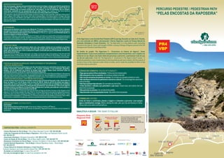
- 1. Sagres Vila do Bispo Lagos Aljezur Marmelete Monchique M Portimão Lagoa Silve Cabo de São Vicente Bensafrim PERCURSO PEDESTRE / PEDESTRIAN PATH “PELAS ENCOSTAS DA RAPOSEIRA” Promotor/Promoter : Projeto/Project: Co-promotor/Co-promoter: Cofinanciamento/Co-financing: Parceiros/Partners: A Via Algarviana é uma Grande Rota Pedestre (GR13) que liga Alcoutim ao Cabo de S. Vicente, com uma extensão de 300km, atravessando 3 Serras Algarvias e parte do Parque Natural do Sudoeste Alentejano e Costa Vicentina. The “Via Algarviana” is a long distance path connecting AlcoutimtotheCapeSt.Vicent,withalengthof300km,crossing3RangesofAlgarveandpartoftheSW AlentejanoandVicentinaCoastNaturalPark. No âmbito do projeto “Via Algarviana II – Ecoturismo no Interior do Algarve”, foram implementados 12 percursos pedestres complementares a esta Grande Rota, com o objetivo do turista ter ao seu dispor uma maior oferta de percursos a percorrer, e permanecer mais do que um dia em cada local. Under the "Via Algarviana II - Ecotourism in the Algarve Inland" project, 12 additional pedestrian routes complementary to this long distance path were created, with the purpose of tourists to have at their disposal a wider choice of routes, and to create the possibility for them to stay morethanadayoneachplace. CÓDIGODECONDUTA/RULESOFCONDUCT: •Sigaapenaspelostrilhossinalizados/Followonlythemarkedpaths; •Nãoabandoneolixonocaminho/Donotleaverubbishinthetrail; •Nãorecolhaamostrasdeplantasourochas/Donottakeanysamplesofplantsorrocks; •Nãodanifiqueelementosdopatrimónionaturaloucultural/Donotdamagethenaturaland culturalheritage; •Nãofaçaqualquertipodelume/Donotmakeanykindoffire; • Evite barulhos e atitudes que perturbem a paz local / Avoid noise and actions that can disturbthelocalpeople; •Nãoperturbeosanimais/Donotdisturbthewildlife; •Sejaeducadocomaspopulaçõeslocais/Bepolitetothelocalpeople. CONSELHO/ADVISE: Antes de iniciar a caminhada, planeie a viagem e o itinerário a percorrer. Leve sempre água e mantimentos consigo. Before starting the walk, plan your trip and itinerary to follow. Alwaystakesomewaterandfoodwithyou. SINALÉTICA A SEGUIR / THE SIGNS TO FOLLOW : BARRANCODOBENAÇOITÃO Este local tranquilo, agreste e de extraordinária beleza serviu de refúgio a antigos guerrilheiros apoiantes da causa do Rei D. Miguel (1802-1866), a partir do ano de 1834, data de implantação do regime liberal em Portugal. Sabemos que um homem conhecido por João Moleiro, do sítio da Guadalupe, aqui se refugiou numa gruta, acabando por ser assassinado por um João Pacheco (que recebeu um fato como forma de pagamentopeloserviço)amandodaesposadeumadassuasvítimas,MariadaCruzPablos. Thisquietplace,wildandwithextraordinarybeauty,servedasarefugeforformerguerrillas,supportersofthecauseof King D. Miguel (1802-1866), from the year 1834, date of implementation of the liberal regime in Portugal. We know that a man known as João Moleiro (John Miller), from the site of Guadalupe, here took refuge in a cave, he was finally killed by João Pacheco (who received a suit as payment for the service) at the behest of the wife of one of his victims, MariadaCruzPablos. ALTODEMILREI Neste ponto de referência, que marca uma altitude de 113 metros, convidamo-lo a observar todo o ambiente paisagísticoenvolvente,ondesedestacammenires,camposagrícolaseoimensoOceano.Denascentepara poente,omaisdistantepontovisíveléoCerrodaAtalaia(naPraiadaLuz,Lagos)e,naextremidadeoposta,os famososemágicosrochedosdeSagres. Atthispointofreference,whichmarksanaltitudeof113meters,weinviteyoutowatchallthesurroundinglandscaped environment, which features menhirs, farmland and the immense ocean. East to the west, the farthest point that is visibleistheCerrodaAtalaia(inLuzBeach,Lagos)andattheoppositeend,thefamousandmagicalSagresrocks. HORTASDOTABUAL Não se sabe as origens desta pitoresca aldeia rural, mas existem notícias da sua existência na primeira metade do século XVIII. Por esses tempos, tal como hoje, já fazia parte da Freguesia de Vila do Bispo. Se puder, pare, aprecie as ruas e entre na pequenina Capela, construída pelo povo da localidade, em honra de NossaSenhoradeFátima. We do not know the origins of this picturesque rural village, but we have news of its existence in the first half of the eighteenth century. For those times, like today, was already part of the Civil Parish of Vila do Bispo. If you can, stop, enjoythestreetsandenterintothetinyChapel,builtbythepeopleofthisplace,inhonorofNossaSenhoradeFátima. PONTOSDEINTERESSENADERIVAÇÃO/POINTSOFINTERESTATTHEDERIVATION: •JOÃOVAZ,INGRINAEZAVIAL •FORTEEBATERIADOZAVIAL/FORTANDBATTERYOFZAVIAL Estes 3 locais encontram-se implantados num dos mais belos trechos de costa desta zona do Algarve, com falésias imponentes, rochedos rendilhados e, até, curiosas cavidades. A sua localização geográfica, também, não foi indiferente aos homens de tempos mais antigos. Nestes locais ocorreram casos de contrabandodeprata,noséculoXVI,nazonalitoraljuntoàRaposeira. ThesethreeplacesaredeployedinoneofthemostbeautifulstretchesofthecoastofthispartofAlgarve,withtowering cliffs,lacyrocksandevencuriouscavities.Itsgeographicallocation,too,wasnotindifferenttomenofancienttimes.In theseplacestherewerecasesofsilversmugglinginthesixteenthcentury,inthecoastalareaneartheRaposeira. O Forte de Santo Inácio do Zavial foi mandado construir perto da Ponta da Fisga pelo, então, Governador do Reino do Algarve, D. Luís de Sousa, entre os anos de 1630-33. Sabe-se que foi ele próprio que pagou a construção que serviu para proteger o local e a armação de pesca de atum ali existente dos constantes ataques da pirataria norte-africana. Foi destruído pelo terramoto de 1 de novembro de 1755 e no seu lugar foi mandada construir uma Bateria na Ponta da Fisga, artilhada com 2 canhões, para defender a zona costeira, e queteveumaexistênciaoperacionalatéaoséculoXIX. The Fort of Santo Inácio of Zavial was built near the Ponta da Fisga by the then Governor of the Kingdom of the Algarve, D. Luís de Sousa, between the years 1630-33. It is known that it was he who paid the building that served to protect the place and there existing tuna fishing frame of the constant attacks of the North African piracy. It was destroyed by the earthquake of 1 of November of 1755 and in its place was built a Battery at Ponta da Fisga, artillery with2cannons,todefendthecoastalzone,andhadanoperationalexistenceuntilthenineteenthcentury. EVENTOSCULTURAIS/CULTURALEVENTS: RAPOSEIRA th-FestadeNossaSenhoradaEncarnação(24demarço);ReligiousFestivity(24 March); -Feira anual e Festa Popular (2º fim de semana de setembro); Raposeira’s Annual festivity (second weekend of September); ANODEEDIÇÃO/YEAROFEDITION2015 PR4 VBP - Câmara Municipal de Vila do Bispo / Vila do Bispo Municipal Council: +351 282 630 600 - União das Freguesias de Vila do Bispo e Raposeira / Vila do Bispo and Raposeira Parish Council: +351 282 639 101 - Associação Almargem / Almargem Association: +351 289 412 959 - Centro de Saúde de Vila do Bispo / Vila do Bispo Health Centre: +351 282 639 179 - Bombeiros Voluntários de Vila do Bispo / Voluntary Fire-fighters of Vila do Bispo: +351 282 639 285 - Guarda Nacional Republicana – Vila do Bispo / National Republican Guard – Vila do Bispo: +351 282 630 010 - Parque Natural do Sudoeste Alentejano e Costa Vicentina / Sudoeste Alentejano and Costa Vicentina Natural Park: +351 283 322 735 - Se detetar um incêndio ligue / In case of fire call: 117 - Em caso de emergência ligue / In case of an emergency call: 112 CONTACTOS ÚTEIS / USEFULL CONTACTS: Sagres Vila do Bispo Lagos Aljezur Marmelete Monchique Messines Alte Salir Vaqueiros Furnazinhas Balurcos Alcoutim Portimão Lagoa Silves Albufeira Loulé São Brás de Alportel Tavira Castro Marim Vila Real de St. António Faro Olhão Cabo de São Vicente Via Algarviana Ligações/Links Barranco do Velho Cachopo Parises VOCÊ ESTÁ AQUI YOU ARE HERE Bensafrim
- 2. Perfil topográfico com derivação / Topography with derivation: Altitude(m) Distância / Distance (m) 120 80 40 0 500 10500 Perfil topográfico sem derivação / Topography without derivation: Altitude(m) Distância / Distance (m) 120 80 40 0 2500 7500 12500 FICHA TÉCNICA / TECHNICAL INFORMATION O percurso inicia-se no largo junto à Igreja de Nossa Sr.ª da Encarnação, na Raposeira. Daqui, atravessa a estrada junto aos semáforos em direção à Ingrina e Zavial. No cruzamento vira para o caminho da direita, coincidente em cerca de 200m com a GR 13 - Via Algarviana. Depois segue em frente, sempre ao longo da ribeira da Serra da Borges, que mais à frente se junta com o ribeiro da Zorreira, dando origem à ribeira de Benaçoitão que desagua no mar, na Praia do Barranco. Este é um vale com vegetação verdejante onde sobressaem as fantásticas escarpas e o cantar das aves. Chega-se à Praia do Barranco. Aqui o caminhante pode optar por seguir em direção à Ingrina e Forte do Zavial (percurso extenso) ou seguir diretamente para os Menires. The path starts near the Church of Nossa Sr.ª da Encarnação, in Raposeira. Hence, cross the road at the traffic lights towards Ingrina and Zavial.At the intersection turns to the path of the right coincident at about 200m with GR 13 - Via Algarviana. Then move on, always along the riverside of the Serra da Borges, who later joins the brook of Zorreira, giving rise to the small river of Benaçoitão that flows into the sea, Barranco Beach.This is a valley with lush vegetation protruding the fantastic cliffs and the singing of birds. Reach the Barranco Beach. Here the walker can choose to head towardsIngrinaandFortedoZavial(longpath)orfollowdirectlytothemenhirs. Aqui toma um caminho que sobe, passando pela Praia de João Vaz e Praia da Ingrina. Daqui percorre cerca de 250m em estrada para depois virar para a direita e encontra as ruínas do Forte do Zavial. Terá que percorrer o mesmo caminho de volta até à bifurcação junto à Praia do Barranco, para tomar o percurso em direçãoaosMenires. HeretakeapaththatgoesupthroughtheJoãoVazBeachandIngrinaBeach.Itrunsabout250montheroadandthen turn right and go see the ruins of Zavial Fort. You will have to follow the same path back, to the bifurcation next to the BarrancoBeach,totakethepathtowardsthemenhirs. Aqui toma um caminho que segue junto ao Barranco, passando depois perto de pinheiros e mais tarde de casas. Chegando à estrada alcatroada o percurso segue para a esquerda, encontrando, a 200m, o Menir do Padrão e, caminhando mais 700m, encontrará o Menir do Milrei num caminho à direita. Segue-se por esse caminho,passandoporplantaçõesdepinheirosetoma-seocaminhodaesquerdachegandoaocruzamento, em direção a Hortas do Tabual. Atravessa-se esta pequena povoação, passa-se junto à Capelinha e desce-se em direção à ribeira dos Outeiros. Inicialmente atravessa-se esta linha de água e depois toma-se o caminho à esquerdaqueseguejuntoaesta,alcançando-semaisàfrenteumcruzamentodeestradaasfaltadaeaGR13- ViaAlgarviana.Vira-seàesquerdaesegue-seomesmopercursodestaGrandeRotaatéaopontoinicial. HeretakeapaththatfollowsnexttheBarranco,thenpassingnearpinesandlaterathouses.Arrivingtothepavedroad the path goes to the left, finding, at 200m, the Padrão Menhir, walking more 700m, find Milrei Menhir in a path at the right. It follows that path, passing through pine plantations and takes the path at left reaching the intersection, towards to Hortas do Tabual. Crosses this small village, passes right next to the Chapel and down in the direction of the Outeiros small river.Initially crosses thiswaterline,andthentakeupthepathtotheleftfollowingnexttoit,reachingup ahead one crossing at paved road and the GR 13 - ViaAlgarviana. Turns to the left and follows the same path of this LongDistancePathtothestartingpoint. -Percursoextenso/Longpath|Derivação/Derivation-4,5km(idaevolta/roundtrip): -Continuaçãodopercurso/Continuationofthepath: DESCRIÇÃO DO ITINERÁRIO / ROUTE DESCRIPTION: O QUE PODE VER? / WHAT CAN YOU SEE? RAPOSEIRA Aqui residiu outrora o Infante Dom Henrique. Dado o seu carácter tipicamente rural, é possível encontrar moinhos, poços, fontes, um antigo chafariz em pedra, o Rossio das Eiras (zona ocupada por feirantes)assimcomovestígiosdaabundanteatividadepiscatóriaeagrícola. A antiga ocupação Neolítica na região dotou a Raposeira de uma invejável concentração de monumentos megalíticos, dos quais se destacam o Menir do Padrão (com cerca de 6500 anos) e o Menir deAspradantas,monumentosdecultodeíndolemágico-religiosa. Já mais recente, destacam-se a Capela de Nossa Senhora de Guadalupe e a Igreja Matriz de Nossa Senhora da Encarnação. A primeira, classificada como Monumento Nacional, frequentada pelo Infante Dom Henrique e decerto por outros navegadores também, foi a única construção religiosa da zona a resistir ao Terramoto de 1755. A segunda, original do século XVI, evidencia o estilo Manuelino no arco daCapela-Mor. Na zona litoral, no esporão rochoso da Ponta da Fisga destacam-se as ruínas da Bateria e consegue-se observartambémasdoFortedeSantoInáciodoZavial. Here lived the Infante Dom Henrique. Given their typically rural character, you can find mills, wells, fountains, an old fountain in stone, the Rossio das Eiras (area occupied by merchants) as well as vestiges of the abundant fishingandfarmingactivity. The ancient Neolithic occupation in the region endowed Raposeira an enviable concentration of megalithic monuments among which are the Padrão Menhir (about 6500 years) and the Aspradantas Menhir, cult monumentsofmagical-religiousnature. Already more recent, we highlight the Chapel of Nossa Senhora de Guadalupe and the Main Church of Nossa SenhoradaEncarnação.Thefirst, classified as aNationalMonument, frequentedbyInfanteDomHenriqueand certainly for other navigators too, was the only religious building in the area who resisted the 1755 earthquake. Thesecond,originalsixteenthcentury,showstheManuelinestyleinthearchoftheCapela-Mor. Inthecoastalzone,intherockyspurofPontadaFisgahighlighttheruinsofthebatteryandcanalsoobservethe FortofSantoInácioofZavial IGREJADENOSSASENHORADAENCARNAÇÃO/CHURCHOFNOSSASENHORADAENCARNAÇÃO É a sede da Paróquia da Raposeira. Não se sabem com exatidão as suas origens, contudo, alguns dos elementos artísticos existentes remontam ao século XVI. A Igreja é detentora de interessantíssimos elementos da Arte Manuelina (nomeadamente, os pórticos), arte muito ligada ao período da expansão portuguesapelomundo. It is the headquarters of the Parish of Raposeira. Do not know exactly its origins, however, some of the existing artisticelementsdatebacktothesixteenthcentury.TheChurchholdsveryinterestingelementsofManuelineArt (includinggateways),closelylinkedtotheperiodofPortugueseexpansionintheworld. LOCALIZAÇÃO / LOCATION: ACESSOS / ACESS: PONTO DE PARTIDA E DE CHEGADA / STARTING AND ARRIVAL POINT: EXTENSÃO / EXTENSION : GRAU DE DIFICULDADE / DIFFICULTY LEVEL: DURAÇÃO (APROXIMADA) / DURACTION: ALTITUDE MÁXIMA / MAXIMUM ALTITUTE: ALTITUDE MINIMA / MINIMUM ALTITUTE: SUBIDA ACUMULADA SEM DERIVAÇÃO / ACCUMULATED CLIMB WITHOUT THE DERIVATION: DESCIDA ACUMULADA SEM DERIVAÇÃO / ACCUMULATED DESCENT WITHOUT THE DERIVATION: SUBIDA ACUMULADA COM DERIVAÇÃO / ACCUMULATED CLIMB WITH THE DERIVATION: DESCIDA ACUMULADA COM DERIVAÇÃO / ACCUMULATED DESCENT WITH THE DERIVATION: Região do Algarve, Concelho de Vila do Bispo, União de Freguesias de Vila do Bispo e Raposeira. Algarve region, Municipality of Vila do Bispo, Civil Parish of Vila do Bispo and Raposeira. - DE CARRO / BY CAR: Pela Estrada Nacional 125, na direção de Sagres, virar à direita depois dos semáforos, em direcção ao centro da Raposeira. By the National Road 125, in the direction of Sagres, turn right after the traffic lights, towards the center of Raposeira. No largo junto à Igreja da Raposeira. In the square near the Raposeira Church (N 37° 4'57.63"; W 8°53'23.91") 13,7 km (Percurso pequeno / Small path) ou/or 18,2km (com a derivação até ao Forte do Zavial / with the derivation to Zavial Fort). algo difícil / somewhat difficult 4h ou/or 5h (com a derivação/with the derivation) 113m (Menir do Milrei) 8m (Praia do Barranco) 290 m 336 m 337 m 323 m muito fácil / very easy fácil / easy difícil / hard muito difícil / very hard. • • • • DERIVAÇÃO OU RAMAL / DERIVATION: 4,5 km (ida e volta / round trip) Praia do Barranco | Forte do Zavial Sim / Yes Sim / Yes Todo o ano, embora a altura de primavera seja a mais bonita em termos florísticos e pelas condições climatéricas. All year round, although springtime is the most beautiful in terms of flora and weather conditions Traçado do percurso nas Cartas Militares de Portugal nº 601 e 609, provenientes do Instituto Geográfico do Exército. Tracing of the route in the Portuguese Military Maps nº 601 e 609, from the Geographic Institute of the Army. EXTENSÃO / EXTENSION: PONTO DE INÍCIO /STARTING POINT | PONTO DE CHEGADA / ARRIVAL POINT: DISPONIBILIDADE DE ÁGUA / WATER AVAILABILITY: MERCEARIAS LOCAIS / GROCERIES: ÉPOCA ACONSELHADA / ADVISED SEASON: CARTOGRAFIA / CARTOGRAPHY: Percurso Pedestre Registado e Homologado por / Pedestrian Path Registered and Approved By: