7th euregeo volume_1 164_165
•
0 gostou•269 visualizações

This document discusses a project called AutoMAPticS that aims to improve soil mapping in Portugal using digital soil mapping techniques. The project uses artificial neural networks to predict soil classes in unmapped areas of Portugal based on relationships learned from existing soil maps and landscape data. The goals are to complete soil map coverage in Portugal at a scale of 1:100,000 and harmonize different regional soil classifications to improve transnational data integration. The document provides background on soil mapping efforts in Portugal and challenges with existing maps. It also describes how artificial neural networks can be trained on landscape and soil data to generate new digital soil maps.

Recomendados
Recomendados
Mais conteúdo relacionado
Mais procurados
Mais procurados (20)
Destaque
Destaque (12)
Semelhante a 7th euregeo volume_1 164_165
Semelhante a 7th euregeo volume_1 164_165 (20)
Mais de Ricardo Brasil
Mais de Ricardo Brasil (17)
Último
Último (20)
7th euregeo volume_1 164_165
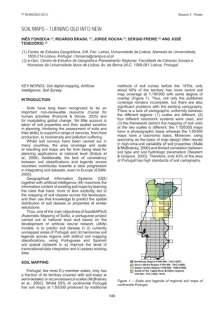
- 1. 146 7th EUREGEO 2012 Session 2 - Poster SOIL MAPS – TURNING OLD INTO NEW INÊS FONSECA (1) ; RICARDO BRASIL (1) ; JORGE ROCHA (1) ; SÉRGIO FREIRE (2) AND JOSÉ TENEDÓRIO (2) (1) Centro de Estudos Geográficos, Edf. Fac. Letras, Universidade de Lisboa, Alameda da Universidade, 1600-214 Lisboa, Portugal. i.fonseca@campus.ul.pt (2) e-Geo, Centro de Estudos de Geografia e Planeamento Regional, Faculdade de Ciências Sociais e Humanas da Universidade Nova de Lisboa, Av. de Berna 26-C, 1069-061 Lisboa, Portugal. KEY WORDS: Soil digital mapping, Artificial Intelligence, Soil Survey. INTRODUCTION Soils have long been recognized to be an important non-renewable resource crucial for human activities (Potocnik & Dimas, 2005) and for modulating global change. Yet little account is taken of soil properties and their spatial variation in planning, hindering the assessment of soils and their ability to support a range of services, from food production, to biodiversity and pollution buffering. Whilst soil surveys have been carried out in many countries, the area coverage and scale of resulting soil maps are far from being ideal for planning applications at national level (Dobos et al., 2006). Additionally, the lack of consistency between soil classifications and legends across countries contributes towards a slow progression in integrating soil datasets, even in Europe (ESBN, 2005). Geographical Information Systems (GIS) together with artificial intelligence (AI) maximize the information content of existing soil maps by learning the rules that have, more or less explicitly, led to the mapping of soil classes across the landscape, and then use that knowledge to predict the spatial distribution of soil classes or properties at similar resolutions. Thus, one of the main objectives of AutoMAPticS (Automatic Mapping of Soils), a portuguese project carried out at national level and based on the development of artificial neural network (ANN) models, is to predict soil classes in (i) currently unmapped areas of Portugal, and (ii) harmonise soil legends across regions with distinct soil mapping classifications, using Portuguese and Spanish soil spatial datasets to a) improve the level of transnational data integration and b) assess existing data. SOIL MAPPING Portugal, like most EU member states, only has a fraction of its territory covered with soil maps at semi-detailed or reconnaissance scales (McBratney et al., 2003). Whilst 55% of continental Portugal has soil maps at 1:50000 produced by traditional methods of soil survey before the 1970s, only about 40% of the territory has more recent soil map coverage at 1:100000 with some degree of overlap (Figure 1). Thus, not only the published coverage remains incomplete, but there are also significant problems with the existing cartography. There is a lack of cartographic uniformity between the different regions: (1) scales are different, (2) four different taxonomic systems were used, and (3) the framework behind the mapping of soil units at the two scales is different: the 1:100000 maps have a physiographic basis whereas the 1:50000 maps have a taxonomic basis. Moreover, using taxonomy as the basis of map design often results in high intra-unit variability of soil properties (Mulla & McBratney, 2000) and limited correlation between soil type and soil hydrologic parameters (Western & Grayson, 2000). Therefore, only 43% of the area of Portugal has high standards of soil cartography. Figure 1 – Scale and legends of regional soil maps of continental Portugal.
- 2. 147 7th EUREGEO 2012 Session 2 - Poster The Portuguese soil map coverage provides an outstanding opportunity for advancing Digital Soil Mapping (DSM) because (1) half the country has high quality soil-map coverage for which a very large number of geo-referenced soil samples were collected, (2) there are geo-referenced soil profile data at a number of sites throughout the unmapped area, and (3) there are also soil maps at different scales. Additionally, as soil units are not coterminous with political soil maps, Spanish soil spatial datasets were collated to allow a better integration of the Portuguese soil cartography at an international level. SPATIAL MODELLING OF SOILS USING GIS & ARTIFICIAL INTELLIGENCE With the technologies available today, such as GIS, which allow storage and retrieval of large amounts of spatial data, including of those which are considered to be the main factors of soil formation and development (Irvin et al., 1997; MacMillan et al., 2000), combined with advances in Artificial Neural Networks (ANN) and Fuzzy Logic (FL), it has become possible to map the spatial distribution of soils in a cheaper, more consistent and flexible way, using surrogate landscape data. Thus, ANN models are used to translate knowledge of soil-survey, which is encapsulated in existing soil maps, into relationships between soils and landscape features in order to predict soil types in unmapped areas for which the landscape characteristics are known. In this way, first-order digital soil maps are used to generate third-order ones (Behrens & Scholten, 2006). During the training phase, the ANN learns about regularities present in the datasets (soil classes and landscape features, i.e. digital terrain data, land cover, lithology) and, based on these regularities constructs rules (Tso & Mather, 2001) that can be extended to the unmapped areas. The ANN is trained by presenting it a number of different examples of the same object (i.e. different landscape-feature vectors for a certain soil type) and this methodology is applied to each pilot region in Portugal and Spain and at different resolutions. FUTURE PERSPECTIVES AND NEEDS Processes involved in soil development do not usually operate on a discrete level but produce a continuum of change (McBratney & Odeh, 1997). Also, according to the same authors, imprecision and uncertainty are inherent parts of natural systems. Fuzzy Logic is an approach that can address the continuous nature of soil in DSM. There is a natural synergy between ANNs and FL that makes their hybridization powerful for DSM, which will be later developed in this project. Results obtained using both methodologies will be compared and validated using existing maps and soil profile data, and the best model will be used to map soil classes across areas which are currently lacking spatial soil data. Thus, the main aim of AutoMAPticS is to complete the Portuguese soil map coverage at 1:100000. ACKNOWLEDGEMENTS AutoMAPticS is supported by PTDC/CS- GEO/111929/2009, a grant from FCT – Foundation for Science and Technology (Portugal), and the principal investigator is employed under the FCT Science 2008 Programme. REFERENCES BEHRENS T. & SCHOLTEN T. (2006) Digital soil mapping in Germany – a review. J. Plant Nutr. Soil Sci., 169, 434-443. DOBOS E., CARRÉ F., HENGL T., REUTER H.I. & TÓTH G. (2006) Digital Soil Mapping as a Support to Pro- duction of Functional Maps. EUR 22123 EN. Office for Official Publications of the European Communities, Luxemburg, 68pp. ESBN (EUROPEAN SOIL BUREAU NETWORK) (2005) Soil Atlas of Europe. European Commission, Office for Official Publications of the European Communi- ties, L-2995 Luxemburg, 128pp. IRVIN B.J., VENTURA S.J. & SLATER B.K. (1997) Fuzzy and isodata classification of landform elements from digital terrain data in Pleasant Valley, Wisconsin. Ge- oderma, 77, 137-154. MACMILLAN R.A., PETTAPIECE W.W., NOLAN S.C. & GODDARD T.W. (2000) A generic procedure for au- tomatically segmenting landforms into landform ele- ments using DEMs, heuristic rules and fuzzy logic. Fuzzy Sets & Systems, 113, 81-109. MCBRATNEY A.B., MENDONÇA SANTOS M.L., MINA- SNY B. (2003) On digital soil mapping. Geoderma, 117, 3-52. MCBRATNEY A.B. & ODEH I.O.A. (1997) Application of fuzzy sets in soil science: fuzzy logic, fuzzy measur- ments and fuzzy decisions. Geoderma, 77, 85-113. MULLA D.J. & MCBRATNEY A.B. (2000) Soil spatial va- riability. In M.E. Sumner (Ed.) Handbook of Soil Scien- ce, A 321-352. CRC Press, Boca Raton. POTOCNIK J. & DIMAS S. (2005) Preface. In Soil Atlas of Europe. European Soil Bureau Network. Europe- an Commission, Office for Official Publications of the European Communities, L-2995 Luxemburg, 128pp. TSO B. & MATHER P.M. (2001) Classification Methods for Remotely Sensed Data. Taylor and Francis, Lon- don, 332pp. WESTERN A. & GRAYSON R. (2000) Soil moisture and runoff processes at Tarrawarra. In R. Grayson & G. Blöschl (Eds) Spatial Patterns in Catchment Hydro- logy: Observations and Modelling. Cambridge Univer- sity Press, Cambridge, 209-246.