Indicador de Sustentabilidade Institucional para o 3º Setor. Um ferramenta de...
Mapa Curuçá - 2 | Corredor
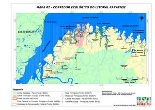
1. MAPA 02 - CORREDOR ECOLÓGICO DO LITORAL PARAENSE
-48°30' -48°00' -47°30' -47°00'
N
OCEANO ATLÂNTICO W E
-0°30'
-0°30'
S
R. Ex. de Soure
R. Ex. Maracanã
R. Ex. Mãe Grande SALINÓPOLIS OCEANO ATLÂNTICO
S
#
de Curuçá
R. Ex. Marinha
ILHA DO MARAJÓ MARAPANIM de Tracuateua
SÃO CAETANO S
#
DE ODIVELAS S
#
S
# CURUÇÁ S MARACANÃ
# S
#
R. Ex. de São S
# SÃO JOÃO
MAGALHÃES DE PIRABAS
João da Ponta BARATA
S
#
JÓ
S VIGIA
# SÃO JOÃO
QUATIPURU
RA
DA PONTA
S
#
MA
SANTARÉM
S
# COLARES S NOVO
#
S
#
DE
PRIMAVERA
-1°00'
-1°00'
ÍA
R. Ex. Marinha
BA
S TERRA ALTA
# Caeté-Taperaçu
S
#
S
#
PA-136
BRAGANÇA
TRACUATEUA
SANTO ANTÔNIO
S
# DO TAUÁ
SANTA BÁRBARA
S
# DO PARÁ
6 SANTA LUZIA
BR-31 DO PARÁ
S
# S
#
SANTA ISABEL
S
#
CASTANHAL
DO PARÁ
ANANINDEUA
S S
# # S
#
MARITUBA BENEVIDES
Y
# BELÉM
0 10 20 30 40 50 km
-1°30'
-1°30'
Projeção: Lat-Long
Datum: SAD-69
-48°30' -48°00' -47°30' -47°00'
Legenda
RESPONSÁVEIS:
Limite Estadual - Pará (Fonte: IBGE) Rios Principais (Fonte: SIGIEP) Marcelo Cordeiro Thalês - M.Sc. Sensoriamento Remoto
Samuel Soares Almeida - M.Sc. Ecologia Florestal
Limite Municipal - Curuçá (Fonte: IBGE) Rodovias Principais (Fonte: SIGIEP)
Limite da Área de Estudo #
Y Capital de Estado - Pará (Fonte: IBGE)
Zona Central do Corredor Ecológico (Fonte: IBAMA) S
# Sede Municipal - Principais (Fonte: IBGE)
Unidades de Conservação Federal (Fonte: IBAMA)
DATA DE ELABORAÇÃO: 26.05.2006