1. Page 1 of 19
IMPORTANT TOPICS
IMPORTANT TOPCS
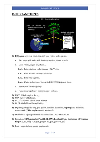
1) Difference between: point, line, polygon, vertex, node, arc, etc.
a. Arc: starts with node, with 0 or more vertices, & end to node.
b. Lines = links, edges, arc, chain…
1.b.1. Edge: start and end with node + No Vertex.
1.b.2. Line: all with vertices + No nodes.
1.b.3. Link: line segment.
1.b.4. Chain: collection of lines with DIRECTION (to and from).
c. Vertex: don’t store topology.
d. Node: store topology + connects arcs + Or lines.
2) USGS: US Geological Survey.
3) SOP: Survey of Pakistan.
4) GLOVIS: Global Visualization Viewer.
5) GLCF: Global Land Cover Facility.
6) Digitizing: shapefile, why, plus points, demerits, extensions, topology and definition,
stream mode (F8 in arcgis), normal point mode...
7) Overview of topological errors and corrections… GO THROUGH.
8) Projection, UTM, zones for Pak (41, 42, 43N), Lambert Conic Conformal LCC (zones
for pak?), lat, long, FOR (lah, punjab, bal, pak, gawader, etc)
9) River: indus, jhelum, names, location, etc.
2. Page 2 of 19
IMPORTANT TOPICS
10) Difference between raster, vector, and image.
11) Raster pyramids: rrd file (ERDAS), ovr (arcgis 10.1>)
a. Resampling tec: nearest, bilinear, cubic…
b. Hill shade
c. Azimuth: The azimuth is the angular direction of the sun, measured from north in
clockwise degrees from 0 to 360. An azimuth of 90º is east.
d. Altitude: The altitude is the slope or angle of the illumination source above the
horizon. The units are in degrees, from 0 (on the horizon) to 90 (overhead).
3. Page 3 of 19
IMPORTANT TOPICS
e. Raster have NO Attributes, unless defined….
12) Difference in spatial and aspatial data.
ArcGIS data type Access data type Notes
OBJECTID Long Integer OBJECTID is an AutoNumber field.
SHORT INTEGER Integer
4. Page 4 of 19
IMPORTANT TOPICS
LONG INTEGER Long Integer
FLOAT Single
DOUBLE Double
TEXT Text
DATE Date/Time
BLOB OLE Object*
GUID Number Replication ID, duplicates allowed
GEOMETRY OLE Object*
RASTER Long Integer
13) Resolution definition: 3 types, spatial, spectral, digital or radiometric, selection in
between what to choose etc.
14) Satellite resolution... landsat, spot, ikonos, quick brid (QB is of Digital Globe), google
earth (QB), pan, mss, bands, hyperspectral, worldview, comparison, any RS or weather,
goes, poes, modis....
Resolutions
SPATIAL
Smallest identifiable
area as a discrete
object in an image
SPECTRAL
No. of frequencies
recorded = sensors
TEMPORAL
Time interval
between
measurements
5. Page 5 of 19
IMPORTANT TOPICS
a. SPATIAL RESOLUTIONS
NOAA-AVHRR (1100 m)
GOES (700 m)
MODIS (250, 500, 1000 m)
Landsat TM and ETM (30 – 60 m)
SPOT (10 – 20 m)
IKONOS (4, 1 m)
Quick-bird (0.6 m)
Serial
No.
Satellites Altitude
(km)
Bands
(µm)
Multi-
spectral
(m)
Panchromatic
(m)
Thermal
(m)
Purpose
01. Landsat-7 705 0.5-0.9,
2.03-2.3
30 15 60 Scientific, RS
03. SPOT-5 822 0.5-0.73 10 2.5-5 - Scientific/commercial
04. IKONOS 681 0.45-0.9 04 01 - Urban & Rural
Mapping etc.
05. Orb-view 480 0.45-0.9 2.4 0.6 - Commercial, Civil
Eng., etc.
6. Page 6 of 19
IMPORTANT TOPICS
06. Quick bird 480 0.45 -
0.9
2.4 0.6 Climate change,
Commercial, etc.
07. Worldivew-
2
770 0.45-
0.80
1.84 0.5 - Commercial as Google
maps, etc.
15) Scales: 3 types, graphical, others,
a. CONVERSION... 1:10000, 1/10000, 1cm=10km etc., inches to meters, cm, km, and
vice versa.
7. Page 7 of 19
IMPORTANT TOPICS
b. Scale of shapefile: none, or digitized scale.
c. Map scale, ratio scale, scale factor...
16) Tolerance
Scale
Verbal Scale Written Scale Scale Text
Fractional
Scale
Representative
Factor
R.F.
Graphical
Scale
Linear Scale Scale Bar
8. Page 8 of 19
IMPORTANT TOPICS
17) Map: def, importance, criteria of good map, user interface for map, types, thematic
and reference, map elements, map body, title, etc.
Types of Map
Reference
Topographic
General
Purpose
Thematic
Statistical
Geological Environmental
9. Page 9 of 19
IMPORTANT TOPICS
a. Balance of map: color combination, background vs above layers, balance, visual
centric, etc.
18) GPS... process, num of satellites, owner, and launch date, 2d, 3d, 4d points,
ACCURACY, etc. (SEE THE MY REGISTER IMAGE)
a. Similar example: GLONASS: Globalnaya Navigazionnaya Sputnikovaya Sistema, or
Global Navigation Satellite System.GLONASS is Russia's version of GPS (Global Position
System)
b. DGPS: Differential GPS: use of two GPS in order to track…?????
11. Page 11 of 19
IMPORTANT TOPICS
19) Coordinate system: GCS, PCS… units… universal units (m), map units (km, mi), page
unit/print (inches, cm)…
12. Page 12 of 19
IMPORTANT TOPICS
20) Join and Relate:
21) Bookmarks: Saving extent, scale, on mxd.
22) Hyperlinks: linking images, doc, ppt, excel, web sites, web pages to map/mxd/ or inside
attribute table.
23) Geo referencing, rectification, image to image registration, image to map
rectification, zero order, affine, spline, RMS Error...
24) Interpolation... options, IDW, krigning, spline, etc.
25) Difference between DEM n DTM.
a. DEM is a subset of DTM and the most fundamental component of DTM.
b. In practice, these terms (DTM, DEM, DHM, and DTEM) are often assumed to be
synonymous and indeed this is often the case. But sometimes they actually refer to
different products. That is, there may be slight differences between these terms. Li
(1990) has made a comparative analysis of these differences as follows:
13. Page 13 of 19
IMPORTANT TOPICS
c. Ground: “the solid surface of the earth”; “a solid base or foundation”; “a surface of
the earth”; “bottom of the sea”; etc.
d. Height: “measurement from base to top”; “elevation above the ground or recognized
level, especially that of the sea”; “distance upwards”; etc.
e. Elevation: “height above a given level, especially that of sea”; “height above the
horizon”; etc.
f. Terrain: “tract of country considered with regarded to its natural features, etc.”; “an
extent of gro5und, region, territory”; etc.
g. http://www.slideshare.net/vino1393/als-seminar
15. Page 15 of 19
IMPORTANT TOPICS
26) Contours:
27) 3D vs 2.5D
a. TIN: Vector format for representing the Elevations.
b. DEM: Raster format.
c. Nothing like this is ACTUAL 3D… they are 2.5D… as they don’t incorporate
elevation in data structure or topology.
d. Arc Scene: Base Height: elevation & Extrusion: 3d extension (point becomes line,
line to polygon, polygon to cube…)… CHECK ARC SCENE!
28) LIDAR:
29) Types of orbits: geostationary, geosynchronous, sun synchronous, High, medium,
low orbit.... altitude, inclination, etc.
a. Geosynchronous: with any inclination…. Synchronized with the earth/geo centric.
16. Page 16 of 19
IMPORTANT TOPICS
b. Geostationary: Geosynchronous orbit with inclination 0 degrees.
c. Polar orbits: to from the poles.
d. Sun synchronous: along with the position of sun.
e. SEE: http://marine.rutgers.edu/cool/education/class/paul/orbits2.html
30) ACCURACY AND PRECESSION:
a. Precision: Defines the overall field length.
b. Scale: Defines the decimal values.These properties are associated with Numeric fields.
In all of the sub-fields of numbers (i.e. float, double etc), these two properties have to
be defined with each of them.
17. Page 17 of 19
IMPORTANT TOPICS
Serial No. Data Type Precision Scale
01. Short Integer 1-5 0
02. Long Integer 6-10 0
03. Double 1-6
04. Float 7+ 0+
c. Accuracy is a measure of correctness.
d. Accuracy could be quantified as ‘Tolerance’.
30.d.1. Example: The distance between two points might be given as 173 meters plus
or minus 2 meters. These bands are generally expressed in probabilistic terms.
31) GEO-DATABASE:
a. Why over shp? Merits…
b. Types:
Key Properties Personal File
18. Page 18 of 19
IMPORTANT TOPICS
Description Original data format
for ArcGIS geo-
databases stored and
managed in Microsoft
Access data files
A collection of various
types of GIS datasets
held in a file system
folder
Number of Users Single user and small
workgroups with
smaller datasets
Single user and small
workgroups:
Storage Capacity 1TB-256TB 2GB
Supported Platforms Supported by Widows Supported by Cross-
platforms
Security Operating Windows
19. Page 19 of 19
IMPORTANT TOPICS
OPEN HYPERLINK FOR ENLARGE IMAGE OF THE FOLLOWING TOPOLOGY: