SlideShare uma empresa Scribd logo
1 de 13
Baixar para ler offline
1
TODAY,
TOMORROW
AND
BEYOND . . .
Designing Mapping Databases for the
Future: UKMap – The Next Generation
Dr Seppe Cassettari
The GeoInformation Group
1963 – 2013 CELEBRATING 50 YEARS OF THE BRITISH CARTOGRAPHIC SOCIETY
The GeoInformation Group
TODAY,
TOMORROW
AND
BEYOND . . .
The UKMap Programme
Conceived in 2007 with Edition 1 of the Specification
Data capture commenced in early 2008
Announced in June 2009
Edition 1 published in November 2009
Edition 11 to be published September 2013
Initially London captured
1963 – 2013 CELEBRATING 50 YEARS OF THE BRITISH CARTOGRAPHIC SOCIETY
Extended into other areas, including rural locations
First overseas pilot in progress
2
TODAY,
TOMORROW
AND
BEYOND . . .
The UKMap Model
Topo Thematic
• More than one map
layer to
accommodate
overlaying features
• Multiple attribution
linked through
common
UKMap
Topo
Topo
Overlay
UKMap
Topo
Topo Base
layer
UKMap
Topo
Points
UKMap
Topo
Address
UKMap
Topo
Building Height
Polygon map data
Point map data
Tables
Unique Classification Code (UCC)
UKMap
Thematic
5k
UKMap
Thematic
25k
UKMap
Thematic
100k
UKMap
Thematic
Boundary
UKMap
Thematic
Network
1963 – 2013 CELEBRATING 50 YEARS OF THE BRITISH CARTOGRAPHIC SOCIETY
references
UKMap
Topo
Ortho
UKMap
Topo
Terrain
UKMap
Topo
Points of Interest
Raster data
Network
TODAY,
TOMORROW
AND
BEYOND . . .
The UKMap Principles
The idea of multiple map layers tied together by
tt ib tiattribution...
The strength lies in the attributes:
• 265 land use codes in a 4 level hierarchy
• 8 land cover type codes
• Creates over 1500 combinations for a single
polygon
1963 – 2013 CELEBRATING 50 YEARS OF THE BRITISH CARTOGRAPHIC SOCIETY
polygon
Polygons making up a residential property can be
subdivided by ‘building’, ‘paved areas’ and
‘vegetation’
3
TODAY,
TOMORROW
AND
BEYOND . . .
The Next Generation
• Currently preparing Edition 3 of the Specification
• Planned as major step forward in the way we
handle complex 3D environments within 2D
representations
1963 – 2013 CELEBRATING 50 YEARS OF THE BRITISH CARTOGRAPHIC SOCIETY
TODAY,
TOMORROW
AND
BEYOND . . .
The Problem(s)
• How to handle multiple overlaying, but not
necessarily inter-connected, features in 2D
mapping terms?
• How to establish relationships between features
and objects that do link?
• How to create inter-connectivity through structured
attribution?
• How to make the data usable in currently available
1963 – 2013 CELEBRATING 50 YEARS OF THE BRITISH CARTOGRAPHIC SOCIETY
software solutions?
4
TODAY,
TOMORROW
AND
BEYOND . . .
The Problem
Canary Wharf,
offices andoffices and
retail, and the
DLR...
1963 – 2013 CELEBRATING 50 YEARS OF THE BRITISH CARTOGRAPHIC SOCIETY
TODAY,
TOMORROW
AND
BEYOND . . .
Mapping something we all inherently
understand?
1963 – 2013 CELEBRATING 50 YEARS OF THE BRITISH CARTOGRAPHIC SOCIETY
5
TODAY,
TOMORROW
AND
BEYOND . . .
Mapping something we all inherently
understand?
1963 – 2013 CELEBRATING 50 YEARS OF THE BRITISH CARTOGRAPHIC SOCIETY
TODAY,
TOMORROW
AND
BEYOND . . .
Mapping something we all inherently
understand?
1963 – 2013 CELEBRATING 50 YEARS OF THE BRITISH CARTOGRAPHIC SOCIETY
6
TODAY,
TOMORROW
AND
BEYOND . . .
Mapping something we all inherently
understand?
1963 – 2013 CELEBRATING 50 YEARS OF THE BRITISH CARTOGRAPHIC SOCIETY
TODAY,
TOMORROW
AND
BEYOND . . .
Six Retail floors, partly below ground
1963 – 2013 CELEBRATING 50 YEARS OF THE BRITISH CARTOGRAPHIC SOCIETY
7
TODAY,
TOMORROW
AND
BEYOND . . .
Six Retail floors, partly below ground
1963 – 2013 CELEBRATING 50 YEARS OF THE BRITISH CARTOGRAPHIC SOCIETY
TODAY,
TOMORROW
AND
BEYOND . . .
Six Retail floors, partly below ground
1963 – 2013 CELEBRATING 50 YEARS OF THE BRITISH CARTOGRAPHIC SOCIETY
8
TODAY,
TOMORROW
AND
BEYOND . . .
Mapping something we all inherently
understand
1963 – 2013 CELEBRATING 50 YEARS OF THE BRITISH CARTOGRAPHIC SOCIETY
TODAY,
TOMORROW
AND
BEYOND . . .
Six Retail floors, partly below ground
1963 – 2013 CELEBRATING 50 YEARS OF THE BRITISH CARTOGRAPHIC SOCIETY
9
TODAY,
TOMORROW
AND
BEYOND . . .
Six Retail floors, partly below ground
1963 – 2013 CELEBRATING 50 YEARS OF THE BRITISH CARTOGRAPHIC SOCIETY
TODAY,
TOMORROW
AND
BEYOND . . .
Six Retail floors, partly below ground
1963 – 2013 CELEBRATING 50 YEARS OF THE BRITISH CARTOGRAPHIC SOCIETY
10
TODAY,
TOMORROW
AND
BEYOND . . .
Pulling apart the 3D world
• Decisions have to be made:
• What is considered to be ground level?
• Are there features that are above ground?
• Are there features below ground?
• What are the relative height displacements between
features, relative to the ground?
• Does one feature, like a railway line, exist in all three
levels?
• Are there features which connect between one layer and
th ?
1963 – 2013 CELEBRATING 50 YEARS OF THE BRITISH CARTOGRAPHIC SOCIETY
another?
TODAY,
TOMORROW
AND
BEYOND . . .
Pulling apart the 3D world
Offices with connections to an
underground retail level and
then connected to a station at athen connected to a station at a
lower level
One object, a railway line , is at ground level,
th b i b id
1963 – 2013 CELEBRATING 50 YEARS OF THE BRITISH CARTOGRAPHIC SOCIETY
then above a river on a bridge
and then in a tunnel
The blue line is ground surface or Base level.
Each feature has a position relative to Base
and if not mapped on base is on the ‘Overlay’
11
TODAY,
TOMORROW
AND
BEYOND . . .
Principles to mapping
• Determine ground level
• This may be variable relative to datum
• Map all features at ground level and attribute as
the Base layer.
• No overlapping polygons and no gaps
• Identify all features at different levels above
ground and map each independently on the
‘overlay’ layer.
• Overlapping polygons permitted
1963 – 2013 CELEBRATING 50 YEARS OF THE BRITISH CARTOGRAPHIC SOCIETY
• Attribution defines level relative to Base
• Add relative height code to denote separation from Base
TODAY,
TOMORROW
AND
BEYOND . . .
Principles to mapping (2)
• Identify all features at different levels below ground
and map each independentlyp p y
• Overlapping polygons permitted
• Attribution defines level relative to Base
• Add relative height code to denote separation from Base
• Where features in one map layer connect to
features in another layer, locate and add
‘Connectors’
• Connectors are small polygons which join features in two
or more layers
1963 – 2013 CELEBRATING 50 YEARS OF THE BRITISH CARTOGRAPHIC SOCIETY
or more layers
• Common reference attribution is used to establish linkage
12
TODAY,
TOMORROW
AND
BEYOND . . .
How it works
1963 – 2013 CELEBRATING 50 YEARS OF THE BRITISH CARTOGRAPHIC SOCIETY
TODAY,
TOMORROW
AND
BEYOND . . .
How it works
1963 – 2013 CELEBRATING 50 YEARS OF THE BRITISH CARTOGRAPHIC SOCIETY
13
TODAY,
TOMORROW
AND
BEYOND . . .
Cartographic Challenge
• The complexity of the mapping presents a number
of cartographic challenges.
• Multi layer viewsMulti layer views
• Dynamic representations
• 3D extrapolations
• Symbolisation options
• Looking for partners to produce experimental
cartographic representations of the Canary Wharf
database.
1963 – 2013 CELEBRATING 50 YEARS OF THE BRITISH CARTOGRAPHIC SOCIETY
• Plan to run a competition at the start of 2014 with a
significant cash prize to stimulate cartographic
innovation
TODAY,
TOMORROW
AND
BEYOND . . .
Thank you
The GeoInformation Group
Telford House
Cow Lane
Fulbourn
1963 – 2013 CELEBRATING 50 YEARS OF THE BRITISH CARTOGRAPHIC SOCIETY
Fulbourn
Cambs
CB21 5HB
t 01223 88007
www.geoinformationgroup.co.uk

Mais conteúdo relacionado

Semelhante a Designing mapping databases for the future: UKMap - the next generation - by Seppe Cassettari

What can lessons from the last 30 years tell us about future mapping? - by To...
What can lessons from the last 30 years tell us about future mapping? - by To...What can lessons from the last 30 years tell us about future mapping? - by To...
What can lessons from the last 30 years tell us about future mapping? - by To...British Cartographic Society
 
Mapping Cybergeographies
Mapping CybergeographiesMapping Cybergeographies
Mapping CybergeographiesStephen Graham
 
CensusGIV - Geographic Information Visualisation of Census Data
CensusGIV - Geographic Information Visualisation of Census DataCensusGIV - Geographic Information Visualisation of Census Data
CensusGIV - Geographic Information Visualisation of Census DataCASA, UCL
 
Game Design 2 (2010): Lecture 7 - Micro and Macro Design
Game Design 2 (2010): Lecture 7 - Micro and Macro DesignGame Design 2 (2010): Lecture 7 - Micro and Macro Design
Game Design 2 (2010): Lecture 7 - Micro and Macro DesignDavid Farrell
 
London 2013 rgs_arrowsmith
London 2013 rgs_arrowsmithLondon 2013 rgs_arrowsmith
London 2013 rgs_arrowsmithcolinarrowsmith
 
A vision to make OSM data the backbone of history across time and space - Int...
A vision to make OSM data the backbone of history across time and space - Int...A vision to make OSM data the backbone of history across time and space - Int...
A vision to make OSM data the backbone of history across time and space - Int...Kohei Otsuka
 
OSCC23 Cultivate, Collaborate, Celebrate, & Innovate!
OSCC23 Cultivate, Collaborate, Celebrate, & Innovate!OSCC23 Cultivate, Collaborate, Celebrate, & Innovate!
OSCC23 Cultivate, Collaborate, Celebrate, & Innovate!shelenn
 
Augmented reality @ libraries
Augmented reality @ librariesAugmented reality @ libraries
Augmented reality @ librariesKai Li
 
From Cymru1900 to GB1900
From Cymru1900 to GB1900From Cymru1900 to GB1900
From Cymru1900 to GB1900Tom Pert
 
Game Design 2: Micro and Macro Data Visualisation
Game Design 2: Micro and Macro Data VisualisationGame Design 2: Micro and Macro Data Visualisation
Game Design 2: Micro and Macro Data VisualisationDavid Farrell
 
Comu346 Lecture 6 Micro & Macro Readings
Comu346   Lecture 6   Micro & Macro ReadingsComu346   Lecture 6   Micro & Macro Readings
Comu346 Lecture 6 Micro & Macro ReadingsDavid Farrell
 
Webmapping: maps for presentation, exploration & analysis
Webmapping: maps for presentation, exploration & analysisWebmapping: maps for presentation, exploration & analysis
Webmapping: maps for presentation, exploration & analysisTimelessFuture
 
The Walker's Map: Designing GPS-enabled mapping for the urban recreational wa...
The Walker's Map: Designing GPS-enabled mapping for the urban recreational wa...The Walker's Map: Designing GPS-enabled mapping for the urban recreational wa...
The Walker's Map: Designing GPS-enabled mapping for the urban recreational wa...British Cartographic Society
 
Moving Objects and Spatial Data Computing
Moving Objects and Spatial Data ComputingMoving Objects and Spatial Data Computing
Moving Objects and Spatial Data ComputingKwang Woo NAM
 

Semelhante a Designing mapping databases for the future: UKMap - the next generation - by Seppe Cassettari (18)

Mapping the Swiss Way esri-ch
Mapping the Swiss Way esri-chMapping the Swiss Way esri-ch
Mapping the Swiss Way esri-ch
 
What can lessons from the last 30 years tell us about future mapping? - by To...
What can lessons from the last 30 years tell us about future mapping? - by To...What can lessons from the last 30 years tell us about future mapping? - by To...
What can lessons from the last 30 years tell us about future mapping? - by To...
 
Mapping Cybergeographies
Mapping CybergeographiesMapping Cybergeographies
Mapping Cybergeographies
 
CensusGIV - Geographic Information Visualisation of Census Data
CensusGIV - Geographic Information Visualisation of Census DataCensusGIV - Geographic Information Visualisation of Census Data
CensusGIV - Geographic Information Visualisation of Census Data
 
Game Design 2 (2010): Lecture 7 - Micro and Macro Design
Game Design 2 (2010): Lecture 7 - Micro and Macro DesignGame Design 2 (2010): Lecture 7 - Micro and Macro Design
Game Design 2 (2010): Lecture 7 - Micro and Macro Design
 
London 2013 rgs_arrowsmith
London 2013 rgs_arrowsmithLondon 2013 rgs_arrowsmith
London 2013 rgs_arrowsmith
 
A vision to make OSM data the backbone of history across time and space - Int...
A vision to make OSM data the backbone of history across time and space - Int...A vision to make OSM data the backbone of history across time and space - Int...
A vision to make OSM data the backbone of history across time and space - Int...
 
Fractals
FractalsFractals
Fractals
 
OSCC23 Cultivate, Collaborate, Celebrate, & Innovate!
OSCC23 Cultivate, Collaborate, Celebrate, & Innovate!OSCC23 Cultivate, Collaborate, Celebrate, & Innovate!
OSCC23 Cultivate, Collaborate, Celebrate, & Innovate!
 
Augmented reality @ libraries
Augmented reality @ librariesAugmented reality @ libraries
Augmented reality @ libraries
 
From Cymru1900 to GB1900
From Cymru1900 to GB1900From Cymru1900 to GB1900
From Cymru1900 to GB1900
 
McDonough "Living with Machines"
McDonough "Living with Machines"McDonough "Living with Machines"
McDonough "Living with Machines"
 
Game Design 2: Micro and Macro Data Visualisation
Game Design 2: Micro and Macro Data VisualisationGame Design 2: Micro and Macro Data Visualisation
Game Design 2: Micro and Macro Data Visualisation
 
Making Infrastructure Work: BIM Meets Geospatial (Rollo Home, Ordnance Survey)
Making Infrastructure Work: BIM Meets Geospatial (Rollo Home, Ordnance Survey)Making Infrastructure Work: BIM Meets Geospatial (Rollo Home, Ordnance Survey)
Making Infrastructure Work: BIM Meets Geospatial (Rollo Home, Ordnance Survey)
 
Comu346 Lecture 6 Micro & Macro Readings
Comu346   Lecture 6   Micro & Macro ReadingsComu346   Lecture 6   Micro & Macro Readings
Comu346 Lecture 6 Micro & Macro Readings
 
Webmapping: maps for presentation, exploration & analysis
Webmapping: maps for presentation, exploration & analysisWebmapping: maps for presentation, exploration & analysis
Webmapping: maps for presentation, exploration & analysis
 
The Walker's Map: Designing GPS-enabled mapping for the urban recreational wa...
The Walker's Map: Designing GPS-enabled mapping for the urban recreational wa...The Walker's Map: Designing GPS-enabled mapping for the urban recreational wa...
The Walker's Map: Designing GPS-enabled mapping for the urban recreational wa...
 
Moving Objects and Spatial Data Computing
Moving Objects and Spatial Data ComputingMoving Objects and Spatial Data Computing
Moving Objects and Spatial Data Computing
 

Mais de British Cartographic Society

Mapping using the convergence of Survey and GIS - by Mike Cooper, Leica Geosy...
Mapping using the convergence of Survey and GIS - by Mike Cooper, Leica Geosy...Mapping using the convergence of Survey and GIS - by Mike Cooper, Leica Geosy...
Mapping using the convergence of Survey and GIS - by Mike Cooper, Leica Geosy...British Cartographic Society
 
Cartography and Geospatial Intelligence (GEOINT): Actionable Knowledge for Hu...
Cartography and Geospatial Intelligence (GEOINT): Actionable Knowledge for Hu...Cartography and Geospatial Intelligence (GEOINT): Actionable Knowledge for Hu...
Cartography and Geospatial Intelligence (GEOINT): Actionable Knowledge for Hu...British Cartographic Society
 
Saving lives at sea: current activities and the use of GIS to understand a we...
Saving lives at sea: current activities and the use of GIS to understand a we...Saving lives at sea: current activities and the use of GIS to understand a we...
Saving lives at sea: current activities and the use of GIS to understand a we...British Cartographic Society
 
Mapping birds, biodiversity and business: the role of GIS in conservation
Mapping birds, biodiversity and business: the role of GIS in conservationMapping birds, biodiversity and business: the role of GIS in conservation
Mapping birds, biodiversity and business: the role of GIS in conservationBritish Cartographic Society
 
A series of deployments as seen through the maps, how they’ve changed and evo...
A series of deployments as seen through the maps, how they’ve changed and evo...A series of deployments as seen through the maps, how they’ve changed and evo...
A series of deployments as seen through the maps, how they’ve changed and evo...British Cartographic Society
 
Mapping the Olympics: the example of the ‘Atlas of world sport’
Mapping the Olympics: the example of the ‘Atlas of world sport’Mapping the Olympics: the example of the ‘Atlas of world sport’
Mapping the Olympics: the example of the ‘Atlas of world sport’British Cartographic Society
 
A century of geographical names: toponymic evolution in Somalia
A century of geographical names: toponymic evolution in SomaliaA century of geographical names: toponymic evolution in Somalia
A century of geographical names: toponymic evolution in SomaliaBritish Cartographic Society
 
A common mapping symbology across national security stakeholders during the 2...
A common mapping symbology across national security stakeholders during the 2...A common mapping symbology across national security stakeholders during the 2...
A common mapping symbology across national security stakeholders during the 2...British Cartographic Society
 
Beyond Google: mapping a new world of open data and open access
Beyond Google: mapping a new world of open data and open accessBeyond Google: mapping a new world of open data and open access
Beyond Google: mapping a new world of open data and open accessBritish Cartographic Society
 
Data, Data, Everywhere. Now integrate & interact with it!
Data, Data, Everywhere. Now integrate & interact with it!Data, Data, Everywhere. Now integrate & interact with it!
Data, Data, Everywhere. Now integrate & interact with it!British Cartographic Society
 

Mais de British Cartographic Society (20)

Cartography and Web GIS - Jack Dangermond
Cartography and Web GIS - Jack DangermondCartography and Web GIS - Jack Dangermond
Cartography and Web GIS - Jack Dangermond
 
Mapping using the convergence of Survey and GIS - by Mike Cooper, Leica Geosy...
Mapping using the convergence of Survey and GIS - by Mike Cooper, Leica Geosy...Mapping using the convergence of Survey and GIS - by Mike Cooper, Leica Geosy...
Mapping using the convergence of Survey and GIS - by Mike Cooper, Leica Geosy...
 
Cartography and Geospatial Intelligence (GEOINT): Actionable Knowledge for Hu...
Cartography and Geospatial Intelligence (GEOINT): Actionable Knowledge for Hu...Cartography and Geospatial Intelligence (GEOINT): Actionable Knowledge for Hu...
Cartography and Geospatial Intelligence (GEOINT): Actionable Knowledge for Hu...
 
Freight Journey Planner for Transport for London
Freight Journey Planner for Transport for LondonFreight Journey Planner for Transport for London
Freight Journey Planner for Transport for London
 
Mapping - for Solutions to Poverty
Mapping - for Solutions to PovertyMapping - for Solutions to Poverty
Mapping - for Solutions to Poverty
 
Saving lives at sea: current activities and the use of GIS to understand a we...
Saving lives at sea: current activities and the use of GIS to understand a we...Saving lives at sea: current activities and the use of GIS to understand a we...
Saving lives at sea: current activities and the use of GIS to understand a we...
 
Mapping birds, biodiversity and business: the role of GIS in conservation
Mapping birds, biodiversity and business: the role of GIS in conservationMapping birds, biodiversity and business: the role of GIS in conservation
Mapping birds, biodiversity and business: the role of GIS in conservation
 
A series of deployments as seen through the maps, how they’ve changed and evo...
A series of deployments as seen through the maps, how they’ve changed and evo...A series of deployments as seen through the maps, how they’ve changed and evo...
A series of deployments as seen through the maps, how they’ve changed and evo...
 
Mapping the Olympics: the example of the ‘Atlas of world sport’
Mapping the Olympics: the example of the ‘Atlas of world sport’Mapping the Olympics: the example of the ‘Atlas of world sport’
Mapping the Olympics: the example of the ‘Atlas of world sport’
 
A century of geographical names: toponymic evolution in Somalia
A century of geographical names: toponymic evolution in SomaliaA century of geographical names: toponymic evolution in Somalia
A century of geographical names: toponymic evolution in Somalia
 
GIS as an artistic medium - rendering the sublime
GIS as an artistic medium - rendering the sublimeGIS as an artistic medium - rendering the sublime
GIS as an artistic medium - rendering the sublime
 
A common mapping symbology across national security stakeholders during the 2...
A common mapping symbology across national security stakeholders during the 2...A common mapping symbology across national security stakeholders during the 2...
A common mapping symbology across national security stakeholders during the 2...
 
3 d visualisation of information
3 d visualisation of information3 d visualisation of information
3 d visualisation of information
 
Cartographic language and portrayal
Cartographic language and portrayalCartographic language and portrayal
Cartographic language and portrayal
 
Which Way Is Up?
Which Way Is Up?Which Way Is Up?
Which Way Is Up?
 
The Beck of Beyond
The Beck of BeyondThe Beck of Beyond
The Beck of Beyond
 
Beyond Google: mapping a new world of open data and open access
Beyond Google: mapping a new world of open data and open accessBeyond Google: mapping a new world of open data and open access
Beyond Google: mapping a new world of open data and open access
 
Contemporary research in cartography within ICA
Contemporary research in cartography within ICAContemporary research in cartography within ICA
Contemporary research in cartography within ICA
 
Data, Data, Everywhere. Now integrate & interact with it!
Data, Data, Everywhere. Now integrate & interact with it!Data, Data, Everywhere. Now integrate & interact with it!
Data, Data, Everywhere. Now integrate & interact with it!
 
Using Sound to Augment 'the Image'
Using Sound to Augment 'the Image'Using Sound to Augment 'the Image'
Using Sound to Augment 'the Image'
 

Último

Advantages of Hiring UIUX Design Service Providers for Your Business
Advantages of Hiring UIUX Design Service Providers for Your BusinessAdvantages of Hiring UIUX Design Service Providers for Your Business
Advantages of Hiring UIUX Design Service Providers for Your BusinessPixlogix Infotech
 
From Event to Action: Accelerate Your Decision Making with Real-Time Automation
From Event to Action: Accelerate Your Decision Making with Real-Time AutomationFrom Event to Action: Accelerate Your Decision Making with Real-Time Automation
From Event to Action: Accelerate Your Decision Making with Real-Time AutomationSafe Software
 
Factors to Consider When Choosing Accounts Payable Services Providers.pptx
Factors to Consider When Choosing Accounts Payable Services Providers.pptxFactors to Consider When Choosing Accounts Payable Services Providers.pptx
Factors to Consider When Choosing Accounts Payable Services Providers.pptxKatpro Technologies
 
A Year of the Servo Reboot: Where Are We Now?
A Year of the Servo Reboot: Where Are We Now?A Year of the Servo Reboot: Where Are We Now?
A Year of the Servo Reboot: Where Are We Now?Igalia
 
Data Cloud, More than a CDP by Matt Robison
Data Cloud, More than a CDP by Matt RobisonData Cloud, More than a CDP by Matt Robison
Data Cloud, More than a CDP by Matt RobisonAnna Loughnan Colquhoun
 
Apidays Singapore 2024 - Building Digital Trust in a Digital Economy by Veron...
Apidays Singapore 2024 - Building Digital Trust in a Digital Economy by Veron...Apidays Singapore 2024 - Building Digital Trust in a Digital Economy by Veron...
Apidays Singapore 2024 - Building Digital Trust in a Digital Economy by Veron...apidays
 
CNv6 Instructor Chapter 6 Quality of Service
CNv6 Instructor Chapter 6 Quality of ServiceCNv6 Instructor Chapter 6 Quality of Service
CNv6 Instructor Chapter 6 Quality of Servicegiselly40
 
08448380779 Call Girls In Friends Colony Women Seeking Men
08448380779 Call Girls In Friends Colony Women Seeking Men08448380779 Call Girls In Friends Colony Women Seeking Men
08448380779 Call Girls In Friends Colony Women Seeking MenDelhi Call girls
 
What Are The Drone Anti-jamming Systems Technology?
What Are The Drone Anti-jamming Systems Technology?What Are The Drone Anti-jamming Systems Technology?
What Are The Drone Anti-jamming Systems Technology?Antenna Manufacturer Coco
 
🐬 The future of MySQL is Postgres 🐘
🐬  The future of MySQL is Postgres   🐘🐬  The future of MySQL is Postgres   🐘
🐬 The future of MySQL is Postgres 🐘RTylerCroy
 
Understanding Discord NSFW Servers A Guide for Responsible Users.pdf
Understanding Discord NSFW Servers A Guide for Responsible Users.pdfUnderstanding Discord NSFW Servers A Guide for Responsible Users.pdf
Understanding Discord NSFW Servers A Guide for Responsible Users.pdfUK Journal
 
Raspberry Pi 5: Challenges and Solutions in Bringing up an OpenGL/Vulkan Driv...
Raspberry Pi 5: Challenges and Solutions in Bringing up an OpenGL/Vulkan Driv...Raspberry Pi 5: Challenges and Solutions in Bringing up an OpenGL/Vulkan Driv...
Raspberry Pi 5: Challenges and Solutions in Bringing up an OpenGL/Vulkan Driv...Igalia
 
Scaling API-first – The story of a global engineering organization
Scaling API-first – The story of a global engineering organizationScaling API-first – The story of a global engineering organization
Scaling API-first – The story of a global engineering organizationRadu Cotescu
 
The Role of Taxonomy and Ontology in Semantic Layers - Heather Hedden.pdf
The Role of Taxonomy and Ontology in Semantic Layers - Heather Hedden.pdfThe Role of Taxonomy and Ontology in Semantic Layers - Heather Hedden.pdf
The Role of Taxonomy and Ontology in Semantic Layers - Heather Hedden.pdfEnterprise Knowledge
 
Presentation on how to chat with PDF using ChatGPT code interpreter
Presentation on how to chat with PDF using ChatGPT code interpreterPresentation on how to chat with PDF using ChatGPT code interpreter
Presentation on how to chat with PDF using ChatGPT code interpreternaman860154
 
How to Troubleshoot Apps for the Modern Connected Worker
How to Troubleshoot Apps for the Modern Connected WorkerHow to Troubleshoot Apps for the Modern Connected Worker
How to Troubleshoot Apps for the Modern Connected WorkerThousandEyes
 
GenCyber Cyber Security Day Presentation
GenCyber Cyber Security Day PresentationGenCyber Cyber Security Day Presentation
GenCyber Cyber Security Day PresentationMichael W. Hawkins
 
How to convert PDF to text with Nanonets
How to convert PDF to text with NanonetsHow to convert PDF to text with Nanonets
How to convert PDF to text with Nanonetsnaman860154
 
Bajaj Allianz Life Insurance Company - Insurer Innovation Award 2024
Bajaj Allianz Life Insurance Company - Insurer Innovation Award 2024Bajaj Allianz Life Insurance Company - Insurer Innovation Award 2024
Bajaj Allianz Life Insurance Company - Insurer Innovation Award 2024The Digital Insurer
 
A Call to Action for Generative AI in 2024
A Call to Action for Generative AI in 2024A Call to Action for Generative AI in 2024
A Call to Action for Generative AI in 2024Results
 

Último (20)

Advantages of Hiring UIUX Design Service Providers for Your Business
Advantages of Hiring UIUX Design Service Providers for Your BusinessAdvantages of Hiring UIUX Design Service Providers for Your Business
Advantages of Hiring UIUX Design Service Providers for Your Business
 
From Event to Action: Accelerate Your Decision Making with Real-Time Automation
From Event to Action: Accelerate Your Decision Making with Real-Time AutomationFrom Event to Action: Accelerate Your Decision Making with Real-Time Automation
From Event to Action: Accelerate Your Decision Making with Real-Time Automation
 
Factors to Consider When Choosing Accounts Payable Services Providers.pptx
Factors to Consider When Choosing Accounts Payable Services Providers.pptxFactors to Consider When Choosing Accounts Payable Services Providers.pptx
Factors to Consider When Choosing Accounts Payable Services Providers.pptx
 
A Year of the Servo Reboot: Where Are We Now?
A Year of the Servo Reboot: Where Are We Now?A Year of the Servo Reboot: Where Are We Now?
A Year of the Servo Reboot: Where Are We Now?
 
Data Cloud, More than a CDP by Matt Robison
Data Cloud, More than a CDP by Matt RobisonData Cloud, More than a CDP by Matt Robison
Data Cloud, More than a CDP by Matt Robison
 
Apidays Singapore 2024 - Building Digital Trust in a Digital Economy by Veron...
Apidays Singapore 2024 - Building Digital Trust in a Digital Economy by Veron...Apidays Singapore 2024 - Building Digital Trust in a Digital Economy by Veron...
Apidays Singapore 2024 - Building Digital Trust in a Digital Economy by Veron...
 
CNv6 Instructor Chapter 6 Quality of Service
CNv6 Instructor Chapter 6 Quality of ServiceCNv6 Instructor Chapter 6 Quality of Service
CNv6 Instructor Chapter 6 Quality of Service
 
08448380779 Call Girls In Friends Colony Women Seeking Men
08448380779 Call Girls In Friends Colony Women Seeking Men08448380779 Call Girls In Friends Colony Women Seeking Men
08448380779 Call Girls In Friends Colony Women Seeking Men
 
What Are The Drone Anti-jamming Systems Technology?
What Are The Drone Anti-jamming Systems Technology?What Are The Drone Anti-jamming Systems Technology?
What Are The Drone Anti-jamming Systems Technology?
 
🐬 The future of MySQL is Postgres 🐘
🐬  The future of MySQL is Postgres   🐘🐬  The future of MySQL is Postgres   🐘
🐬 The future of MySQL is Postgres 🐘
 
Understanding Discord NSFW Servers A Guide for Responsible Users.pdf
Understanding Discord NSFW Servers A Guide for Responsible Users.pdfUnderstanding Discord NSFW Servers A Guide for Responsible Users.pdf
Understanding Discord NSFW Servers A Guide for Responsible Users.pdf
 
Raspberry Pi 5: Challenges and Solutions in Bringing up an OpenGL/Vulkan Driv...
Raspberry Pi 5: Challenges and Solutions in Bringing up an OpenGL/Vulkan Driv...Raspberry Pi 5: Challenges and Solutions in Bringing up an OpenGL/Vulkan Driv...
Raspberry Pi 5: Challenges and Solutions in Bringing up an OpenGL/Vulkan Driv...
 
Scaling API-first – The story of a global engineering organization
Scaling API-first – The story of a global engineering organizationScaling API-first – The story of a global engineering organization
Scaling API-first – The story of a global engineering organization
 
The Role of Taxonomy and Ontology in Semantic Layers - Heather Hedden.pdf
The Role of Taxonomy and Ontology in Semantic Layers - Heather Hedden.pdfThe Role of Taxonomy and Ontology in Semantic Layers - Heather Hedden.pdf
The Role of Taxonomy and Ontology in Semantic Layers - Heather Hedden.pdf
 
Presentation on how to chat with PDF using ChatGPT code interpreter
Presentation on how to chat with PDF using ChatGPT code interpreterPresentation on how to chat with PDF using ChatGPT code interpreter
Presentation on how to chat with PDF using ChatGPT code interpreter
 
How to Troubleshoot Apps for the Modern Connected Worker
How to Troubleshoot Apps for the Modern Connected WorkerHow to Troubleshoot Apps for the Modern Connected Worker
How to Troubleshoot Apps for the Modern Connected Worker
 
GenCyber Cyber Security Day Presentation
GenCyber Cyber Security Day PresentationGenCyber Cyber Security Day Presentation
GenCyber Cyber Security Day Presentation
 
How to convert PDF to text with Nanonets
How to convert PDF to text with NanonetsHow to convert PDF to text with Nanonets
How to convert PDF to text with Nanonets
 
Bajaj Allianz Life Insurance Company - Insurer Innovation Award 2024
Bajaj Allianz Life Insurance Company - Insurer Innovation Award 2024Bajaj Allianz Life Insurance Company - Insurer Innovation Award 2024
Bajaj Allianz Life Insurance Company - Insurer Innovation Award 2024
 
A Call to Action for Generative AI in 2024
A Call to Action for Generative AI in 2024A Call to Action for Generative AI in 2024
A Call to Action for Generative AI in 2024
 

Designing mapping databases for the future: UKMap - the next generation - by Seppe Cassettari

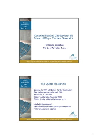
  • 1. 1 TODAY, TOMORROW AND BEYOND . . . Designing Mapping Databases for the Future: UKMap – The Next Generation Dr Seppe Cassettari The GeoInformation Group 1963 – 2013 CELEBRATING 50 YEARS OF THE BRITISH CARTOGRAPHIC SOCIETY The GeoInformation Group TODAY, TOMORROW AND BEYOND . . . The UKMap Programme Conceived in 2007 with Edition 1 of the Specification Data capture commenced in early 2008 Announced in June 2009 Edition 1 published in November 2009 Edition 11 to be published September 2013 Initially London captured 1963 – 2013 CELEBRATING 50 YEARS OF THE BRITISH CARTOGRAPHIC SOCIETY Extended into other areas, including rural locations First overseas pilot in progress
  • 2. 2 TODAY, TOMORROW AND BEYOND . . . The UKMap Model Topo Thematic • More than one map layer to accommodate overlaying features • Multiple attribution linked through common UKMap Topo Topo Overlay UKMap Topo Topo Base layer UKMap Topo Points UKMap Topo Address UKMap Topo Building Height Polygon map data Point map data Tables Unique Classification Code (UCC) UKMap Thematic 5k UKMap Thematic 25k UKMap Thematic 100k UKMap Thematic Boundary UKMap Thematic Network 1963 – 2013 CELEBRATING 50 YEARS OF THE BRITISH CARTOGRAPHIC SOCIETY references UKMap Topo Ortho UKMap Topo Terrain UKMap Topo Points of Interest Raster data Network TODAY, TOMORROW AND BEYOND . . . The UKMap Principles The idea of multiple map layers tied together by tt ib tiattribution... The strength lies in the attributes: • 265 land use codes in a 4 level hierarchy • 8 land cover type codes • Creates over 1500 combinations for a single polygon 1963 – 2013 CELEBRATING 50 YEARS OF THE BRITISH CARTOGRAPHIC SOCIETY polygon Polygons making up a residential property can be subdivided by ‘building’, ‘paved areas’ and ‘vegetation’
  • 3. 3 TODAY, TOMORROW AND BEYOND . . . The Next Generation • Currently preparing Edition 3 of the Specification • Planned as major step forward in the way we handle complex 3D environments within 2D representations 1963 – 2013 CELEBRATING 50 YEARS OF THE BRITISH CARTOGRAPHIC SOCIETY TODAY, TOMORROW AND BEYOND . . . The Problem(s) • How to handle multiple overlaying, but not necessarily inter-connected, features in 2D mapping terms? • How to establish relationships between features and objects that do link? • How to create inter-connectivity through structured attribution? • How to make the data usable in currently available 1963 – 2013 CELEBRATING 50 YEARS OF THE BRITISH CARTOGRAPHIC SOCIETY software solutions?
  • 4. 4 TODAY, TOMORROW AND BEYOND . . . The Problem Canary Wharf, offices andoffices and retail, and the DLR... 1963 – 2013 CELEBRATING 50 YEARS OF THE BRITISH CARTOGRAPHIC SOCIETY TODAY, TOMORROW AND BEYOND . . . Mapping something we all inherently understand? 1963 – 2013 CELEBRATING 50 YEARS OF THE BRITISH CARTOGRAPHIC SOCIETY
  • 5. 5 TODAY, TOMORROW AND BEYOND . . . Mapping something we all inherently understand? 1963 – 2013 CELEBRATING 50 YEARS OF THE BRITISH CARTOGRAPHIC SOCIETY TODAY, TOMORROW AND BEYOND . . . Mapping something we all inherently understand? 1963 – 2013 CELEBRATING 50 YEARS OF THE BRITISH CARTOGRAPHIC SOCIETY
  • 6. 6 TODAY, TOMORROW AND BEYOND . . . Mapping something we all inherently understand? 1963 – 2013 CELEBRATING 50 YEARS OF THE BRITISH CARTOGRAPHIC SOCIETY TODAY, TOMORROW AND BEYOND . . . Six Retail floors, partly below ground 1963 – 2013 CELEBRATING 50 YEARS OF THE BRITISH CARTOGRAPHIC SOCIETY
  • 7. 7 TODAY, TOMORROW AND BEYOND . . . Six Retail floors, partly below ground 1963 – 2013 CELEBRATING 50 YEARS OF THE BRITISH CARTOGRAPHIC SOCIETY TODAY, TOMORROW AND BEYOND . . . Six Retail floors, partly below ground 1963 – 2013 CELEBRATING 50 YEARS OF THE BRITISH CARTOGRAPHIC SOCIETY
  • 8. 8 TODAY, TOMORROW AND BEYOND . . . Mapping something we all inherently understand 1963 – 2013 CELEBRATING 50 YEARS OF THE BRITISH CARTOGRAPHIC SOCIETY TODAY, TOMORROW AND BEYOND . . . Six Retail floors, partly below ground 1963 – 2013 CELEBRATING 50 YEARS OF THE BRITISH CARTOGRAPHIC SOCIETY
  • 9. 9 TODAY, TOMORROW AND BEYOND . . . Six Retail floors, partly below ground 1963 – 2013 CELEBRATING 50 YEARS OF THE BRITISH CARTOGRAPHIC SOCIETY TODAY, TOMORROW AND BEYOND . . . Six Retail floors, partly below ground 1963 – 2013 CELEBRATING 50 YEARS OF THE BRITISH CARTOGRAPHIC SOCIETY
  • 10. 10 TODAY, TOMORROW AND BEYOND . . . Pulling apart the 3D world • Decisions have to be made: • What is considered to be ground level? • Are there features that are above ground? • Are there features below ground? • What are the relative height displacements between features, relative to the ground? • Does one feature, like a railway line, exist in all three levels? • Are there features which connect between one layer and th ? 1963 – 2013 CELEBRATING 50 YEARS OF THE BRITISH CARTOGRAPHIC SOCIETY another? TODAY, TOMORROW AND BEYOND . . . Pulling apart the 3D world Offices with connections to an underground retail level and then connected to a station at athen connected to a station at a lower level One object, a railway line , is at ground level, th b i b id 1963 – 2013 CELEBRATING 50 YEARS OF THE BRITISH CARTOGRAPHIC SOCIETY then above a river on a bridge and then in a tunnel The blue line is ground surface or Base level. Each feature has a position relative to Base and if not mapped on base is on the ‘Overlay’
  • 11. 11 TODAY, TOMORROW AND BEYOND . . . Principles to mapping • Determine ground level • This may be variable relative to datum • Map all features at ground level and attribute as the Base layer. • No overlapping polygons and no gaps • Identify all features at different levels above ground and map each independently on the ‘overlay’ layer. • Overlapping polygons permitted 1963 – 2013 CELEBRATING 50 YEARS OF THE BRITISH CARTOGRAPHIC SOCIETY • Attribution defines level relative to Base • Add relative height code to denote separation from Base TODAY, TOMORROW AND BEYOND . . . Principles to mapping (2) • Identify all features at different levels below ground and map each independentlyp p y • Overlapping polygons permitted • Attribution defines level relative to Base • Add relative height code to denote separation from Base • Where features in one map layer connect to features in another layer, locate and add ‘Connectors’ • Connectors are small polygons which join features in two or more layers 1963 – 2013 CELEBRATING 50 YEARS OF THE BRITISH CARTOGRAPHIC SOCIETY or more layers • Common reference attribution is used to establish linkage
  • 12. 12 TODAY, TOMORROW AND BEYOND . . . How it works 1963 – 2013 CELEBRATING 50 YEARS OF THE BRITISH CARTOGRAPHIC SOCIETY TODAY, TOMORROW AND BEYOND . . . How it works 1963 – 2013 CELEBRATING 50 YEARS OF THE BRITISH CARTOGRAPHIC SOCIETY
  • 13. 13 TODAY, TOMORROW AND BEYOND . . . Cartographic Challenge • The complexity of the mapping presents a number of cartographic challenges. • Multi layer viewsMulti layer views • Dynamic representations • 3D extrapolations • Symbolisation options • Looking for partners to produce experimental cartographic representations of the Canary Wharf database. 1963 – 2013 CELEBRATING 50 YEARS OF THE BRITISH CARTOGRAPHIC SOCIETY • Plan to run a competition at the start of 2014 with a significant cash prize to stimulate cartographic innovation TODAY, TOMORROW AND BEYOND . . . Thank you The GeoInformation Group Telford House Cow Lane Fulbourn 1963 – 2013 CELEBRATING 50 YEARS OF THE BRITISH CARTOGRAPHIC SOCIETY Fulbourn Cambs CB21 5HB t 01223 88007 www.geoinformationgroup.co.uk