Cadastre Information System - Esri IUC 2011, San Diego - CAFernando Gil
FBSIC is supported by a scalable architecture, standards-based information technology and communication, interoperability,ensuring a high sustainability of long-term application.
Allows viewing, editing, analysis and reporting of geographic, alphanumeric,and documental information of land property.
The benefits are evident at the level of operational efciency, with the inclusion of tools to enable process integration and standardization of procedures.
Facilitate analysis and quality control and maximize performance in the acquisition, maintenance and management of registration information and land property, including legal issues.
The implemented system achieves levels of robustness, comprehensiveness, openness, scalability and reliability suitable for a structural platform.
Quarry Detection with GeoAI Tools on Infraestruturas de PortugalFernando Gil
The research focus of the developed work is concentrated on the implementation of Geographic Information Systems – GIS – tools in spatial and temporal contexts, linked to the GIS and Geospatial Information branch of IP.
Through GIS it is possible to visualize, analyse, transform and interpret geographic information. For instance, identification of patterns, trends, and aspects that simplify decision support systems regarding geographical scenarios. Particularly, the work carried out consisted of detecting quarries.
In this context, concepts of Artificial Intelligence, Machine Learning, and Deep Learning were considered. Combined with GIS resources and methodologies, it is conceivable to carry out spatial analysis, remote sensing, and information management, for example.
The mechanisms adopted were initiated from the use of the Esri framework, a provider of geographic information systems, applied in Geographical Artificial Intelligence. GeoAI tools were adopted in the area of quarries, on which the developed work was focused.
Whereas quarries may often be considered as relatively monitored and properly inspected areas, there are scenarios in which they are detected and exceed the specified geographical limits, and situations where they are considered illegal.
Through the available tools, the occurrences mentioned above were intercepted with the national road and railway networks under the company’s supervision. As such, a workflow was developed, implemented, and paired with trained algorithms to obtain an approximate delimitation of the quarries in mainland Portugal.
A pós-graduação em Inteligência Geoespacial (GEOINT Certificate) da NOVA IMS ...Fernando Gil
"O programa de certificação graduada em Inteligência Geoespacial (certificado GEOINT), acreditado pela United States Geospatial Intelligence Foundation (USGIF) disponibiliza educação e formação em conceitos científicos, métodos e tecnologias geoespaciais chave utilizadas na resolução de problemas de segurança humana a nível global, incluindo desastres naturais, crises humanitárias, riscos ambientais, operações militares, violência política, saúde pública e desafios no acesso a fontes de alimentação.
A USGIF (www.usgif.org) é a única organização dedicada à promoção da prática profissional da Inteligência Geoespacial (GEOINT) e à construção de uma comunidade de interesse cruzando a Indústria, a Academia, a Administração Pública e organizações profissionais. A USGIF é a única organização que providencia acreditação universitária na área da GEOINT, sendo a líder mundial nesta área."
Mais informações em http://www.novaims.unl.pt/unigis
Fernando Gil's master thesis: "The implementation of an Enterprise Geographic...Fernando Gil
Abstract
The processes of mobilization of land for infrastructures of public and private domain are developed according to proper legal frameworks and systematically confronted with the impoverished national situation as regards the cadastral identification and regularization, which leads to big inefficiencies, sometimes with very negative impact to the overall effectiveness.
This project report describes Ferbritas Cadastre Information System (FBSIC) project and tools, which in conjunction with other applications, allow managing the entire life-cycle of Land Acquisition and Cadastre, including support to field activities with the integration of information collected in the field, the development of multi-criteria analysis information, monitoring all information in the exploration stage, and the automated generation of outputs. The benefits are evident at the level of operational efficiency, including tools that enable process integration and standardization of procedures, facilitate analysis and quality control and maximize performance in the acquisition, maintenance and management of registration information and expropriation (expropriation projects). Therefore, the implemented system achieves levels of robustness, comprehensiveness, openness, scalability and reliability suitable for a structural platform.
The resultant solution, FBSIC, is a fit-for-purpose cadastre information system rooted in the field of railway infrastructures.
FBSIC integrating nature of allows: to accomplish present needs and scale to meet future services; to collect, maintain, manage and share all information in one common platform, and transform it into knowledge; to relate with other platforms; to increase accuracy and productivity of business processes related with land property management.
Fernando Gil - Master Thesis Public Presentation (25/7/2014)Fernando Gil
The processes of mobilization of land for infrastructures of public and private domain are developed according to proper legal frameworks and systematically confronted with the impoverished national situation as regards the cadastral identification and regularization, which leads to big inefficiencies, sometimes with very negative impact to the overall effectiveness.
This project report describes Ferbritas Cadastre Information System (FBSIC) project and tools, which in conjunction with other applications, allow managing the entire life-cycle of Land Acquisition and Cadastre, including support to field activities with the integration of information collected in the field, the development of multi-criteria analysis information, monitoring all information in the exploration stage, and the automated generation of outputs.
The benefits are evident at the level of operational efficiency, including tools that enable process integration and standardization of procedures, facilitate analysis and quality control and maximize performance in the acquisition, maintenance and management of registration information and expropriation (expropriation projects). Therefore, the implemented system achieves levels of robustness, comprehensiveness, openness, scalability and reliability suitable for a structural platform.
The resultant solution, FBSIC, is a fit-for-purpose cadastre information system rooted in the field of railway infrastructures.
FBSIC integrating nature of allows: to accomplish present needs and scale to meet future services; to collect, maintain, manage and share all information in one common platform, and transform it into knowledge; to relate with other platforms; to increase accuracy and productivity of business processes related with land property management.
Sistemas de Informação Geográfica aplicados à Rede FerroviáriaFernando Gil
Utilização dos SIG nos Caminhos-de-Ferro:
• Cadastro e DPF
• Gestão de Clientes
• Gestão de Emergências
• Gestão Ambiental
• Mitigação Ambiental
• Gestão e Arrendamento de Instalações
• Recolha de Informação no Campo
• Gestão de Imagens
• Comunicação Inter-Ferrovias
• Gestão da Supervisão
• Gestão do Risco e da Segurança
• Manutenção de Diagramas Lineares
• Transportes e Logística
• Gestão dos Trabalhadores
• Gestão de Infra-estruturas
• Projectos de Engenharia e Construção
• Desenhos de Engenharia e Repositório de Registos
• Monitorização de Activos
• Gestão Imobiliária
• Gestão de Riscos, Segurança e Vigilância
• Análise da Cadeia de Fornecimento
Cadastre Information System for Rail in PortugalFernando Gil
The concepts of integration, complementarity and coordination are particularly important especially in the field of railway infrastructures. The requirements of the associated interventions are very technical in nature and involve multiple specialties and technologies, and the final result is only guaranteed if the various components of this interwoven puzzle are compatible and properly joined together.
Produção de Mapas Temáticos com Utilização de Classificação Orientada a Objec...Fernando Gil
Mestrado/Pós-graduação em Ciência & SIG
Trabalho Final - Detecção Remota
Produção de Mapas Temáticos com Utilização de Classificação Orientada a Objectos (Leziria Grande de Vila Franca de Xira)
Base de Dados para Gestão de um Perímetro de Rega - vertentes administrativa,...Fernando Gil
Mestrado/Pós-graduação em Ciência & SIG
Trabalho final da cadeira de Bases de Dados
Base de Dados para Gestão de um Perímetro de Rega - vertentes administrativa, territorial e documental
Cadastre Information System (Brochure ENG)Fernando Gil
In summary, FBSIC enable to maintain an organized and structured database, which identifies
land property in all its aspects - physical, descriptive, legal and tax – allowing to relate
information concerning the owner (documental and alphanumeric) to property (topographic, cartographic, physical, documental and alphanumeric).
Controlo Assistido por Teledetecção às Ajudas às Superfícies Cultivadas ou Forrageiras (2001-2002)
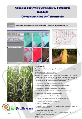
1. Ajudas às Superfícies Cultivadas ou Forrageiras
2001-2002
Controlo Assistido por Teledetecção
Cliente Instituto Nacional de Intervenção e Garantia Agrícola (INGA)
LOCALIZAÇÃO:
Concelhos do Baixo Alentejo e Alentejo Litoral, distritos de Beja e
Setúbal.
CARACTERÍSTICAS PRINCIPAIS:
Análise e controlo de processos candidatos às ajudas
compensatórias no âmbito do Sistema Integrado de Gestão e
Controlo (SIGC), num total de 3400 agricultores abrangendo 650 mil
hectares, sendo as tarefas principais as seguintes:
•Desenvolvimento de programas de controlo;
•Recepção das Bases de Dados Gráfica e Alfanumérica;
•Recepção e Tratamento das Imagens de Satélite;
•Recolha das Parcelas Testemunha (Verdade de Terreno);
•Controlo das Parcelas de Visita Obrigatória;
•Foto-interpretação dos Pedidos de Ajuda;
•Visitas às parcelas com dúvidas de foto-interpretação;
•Introdução dos Resultados das Visitas;
•Análise e Classificação;
•Produção de Relatórios e Documentos Gráficos para a
Confirmação de Terreno;
•Atendimento dos Produtores;
•Produção das Bases de Dados Finais (MS-ACCESS) e Sistema de
T235
Informação Geográfica (MGE).
DATA: 2001