SlideShare uma empresa Scribd logo
1 de 23
CARBON SEQUESTRATION: RESERVOIR CHARACTERIZATION AND POTENTIAL OF EARLY PENNSYLVANIAN BREATHITT GROUP, CENTRAL APPALACHIAN BASIN   Ryan Grimm Virginia Tech Dept. of Geosciences Committee members: Ken Eriksson, Chair Fred Read Bill Henika Steve Greb  - University of Kentucky Early Pennsylvanian Breathitt Group - Raven and Kennedy coal zone roadcut, Grundy Virginia. USACOE Flood Protection Project.  Vertical height ~100m
Carbon Capture and Geological Storage Opportunities in the Pocahontas Basin Objective – Investigate properties of geologic media for long term CO2 storage from a future point source in southwestern Virginia – think FUTUREGEN
Paleozoic Reservoirs and Seals of the Pocahontas Basin Study Interval
ECBM – ENHANCED COAL BED METHANE RECOVERY AND PRODUCTION USING CO2 FLOODS SECARB estimates 398 million tons of technically feasible ECBM - CO 2   storage capacity in the Pocahontas Basin Potential enhanced recovery of >2.5 TCF of CBM gas production Highlights need for increased understanding of surrounding lithologies Regional shale seals & Additional storage capacities / hazards of porous sandstones
Central Appalachian Basin and Pocahontas sub-basin are defined by bounding structures Regional Assessment of Pocahontas sub-basin  Adapted from USGS FS2004-3092 and Chesnut, 1994; Greb and Chesnut, 1996; Korus, 2002; Greb et al., 2004; Greb and Martino, 2005 GEOLOGIC SETTING OF POCAHONTAS BASIN ASSESSMENT REGION Extent of Pennsylvanian Strata
South Dickenson Strike Line 1-4 DATASET
GAMMA RAY SCINTILLOMETRY - FIELD MEASUREMENTS OF LITHOLOGIC RADIOACTIVITY AT GRUNDY
Determine Reservoir Parameters –  Test porosities and permeabilities of shales and sandstones
 
STARVED RIPPLES SANDY RHTHYMITES ORGANIC  PARTINGS
SB SB FS
Neonereites Scalarituba Trace Fossil Analysis
HENSLEY SHALE – KEY REGIONAL DATUM AND SEAL
Raw Data - South Dickenson Strike Line 1
Quartz Arenites - SDS 1
Lithic Arenites – SDS1
Minor Flooding Surfaces – SDS1
Minor Lithic Sands - SDS 1
-  + Sequence Interpretation Basics
Sequences – SDS 1
 
Conclusions ,[object Object],[object Object],[object Object],[object Object]
THANKS! Katie O’Donnell Bill Rouse Erik Haug Ben Roth David Greenwald Brad Kelley Nino Ripepi Ilija Miskovic

Mais conteúdo relacionado

Mais procurados

Mineral Potential Mapping for Pre-Competitive Data Delivery in NSW Zone 54
Mineral Potential Mapping for Pre-Competitive Data Delivery in NSW Zone 54Mineral Potential Mapping for Pre-Competitive Data Delivery in NSW Zone 54
Mineral Potential Mapping for Pre-Competitive Data Delivery in NSW Zone 54Kenex Ltd
 
Mineral potential mapping
Mineral potential mappingMineral potential mapping
Mineral potential mappingKenex Ltd
 
Thesis Presentation
Thesis PresentationThesis Presentation
Thesis Presentationgawump
 
Saby et al., 2016
Saby et al., 2016Saby et al., 2016
Saby et al., 2016Marion Saby
 
The use of Geological information for soil mapping, Raimonda Kasparinskis, Fa...
The use of Geological information for soil mapping, Raimonda Kasparinskis, Fa...The use of Geological information for soil mapping, Raimonda Kasparinskis, Fa...
The use of Geological information for soil mapping, Raimonda Kasparinskis, Fa...FAO
 
ISGS_projectdescriptions
ISGS_projectdescriptionsISGS_projectdescriptions
ISGS_projectdescriptionsOlivier Caron
 
Long Branch Tributary at Long Branch Falls Park Public Meeting 8-20-2015
Long Branch Tributary at Long Branch Falls Park Public Meeting 8-20-2015Long Branch Tributary at Long Branch Falls Park Public Meeting 8-20-2015
Long Branch Tributary at Long Branch Falls Park Public Meeting 8-20-2015Fairfax County
 
Stratigraphical calibration of deep water Cretaceous sequences, offshore mid ...
Stratigraphical calibration of deep water Cretaceous sequences, offshore mid ...Stratigraphical calibration of deep water Cretaceous sequences, offshore mid ...
Stratigraphical calibration of deep water Cretaceous sequences, offshore mid ...Stephen Crittenden
 
Suburban Land Use, Stormwater Best Management Practices, and Receiving Stream...
Suburban Land Use, Stormwater Best Management Practices, and Receiving Stream...Suburban Land Use, Stormwater Best Management Practices, and Receiving Stream...
Suburban Land Use, Stormwater Best Management Practices, and Receiving Stream...David Govoni
 
Carullo gsm 111314
Carullo gsm 111314Carullo gsm 111314
Carullo gsm 111314greenbelt82
 
NERC PhD University of Aberdeen
NERC PhD University of AberdeenNERC PhD University of Aberdeen
NERC PhD University of AberdeenLaura-Jane Fyfe
 
N021203094099
N021203094099N021203094099
N021203094099theijes
 
Hydrocarbon Trapping mechanism and petrophysical analysis of Afam field, offs...
Hydrocarbon Trapping mechanism and petrophysical analysis of Afam field, offs...Hydrocarbon Trapping mechanism and petrophysical analysis of Afam field, offs...
Hydrocarbon Trapping mechanism and petrophysical analysis of Afam field, offs...David Oyeyemi
 
The Impact of Seismic Facies Analysis on the Reservoir Architecture of “CHARL...
The Impact of Seismic Facies Analysis on the Reservoir Architecture of “CHARL...The Impact of Seismic Facies Analysis on the Reservoir Architecture of “CHARL...
The Impact of Seismic Facies Analysis on the Reservoir Architecture of “CHARL...IJSRED
 
2016 Geo Field Tech C.V. PDF
2016 Geo Field Tech C.V. PDF2016 Geo Field Tech C.V. PDF
2016 Geo Field Tech C.V. PDFJeremiah Brower
 

Mais procurados (20)

Mineral Potential Mapping for Pre-Competitive Data Delivery in NSW Zone 54
Mineral Potential Mapping for Pre-Competitive Data Delivery in NSW Zone 54Mineral Potential Mapping for Pre-Competitive Data Delivery in NSW Zone 54
Mineral Potential Mapping for Pre-Competitive Data Delivery in NSW Zone 54
 
Mineral potential mapping
Mineral potential mappingMineral potential mapping
Mineral potential mapping
 
Thesis Presentation
Thesis PresentationThesis Presentation
Thesis Presentation
 
Saby et al., 2016
Saby et al., 2016Saby et al., 2016
Saby et al., 2016
 
The use of Geological information for soil mapping, Raimonda Kasparinskis, Fa...
The use of Geological information for soil mapping, Raimonda Kasparinskis, Fa...The use of Geological information for soil mapping, Raimonda Kasparinskis, Fa...
The use of Geological information for soil mapping, Raimonda Kasparinskis, Fa...
 
ISGS_projectdescriptions
ISGS_projectdescriptionsISGS_projectdescriptions
ISGS_projectdescriptions
 
British Columbia Geological Survey Activities in 2010
British Columbia Geological Survey Activities in 2010British Columbia Geological Survey Activities in 2010
British Columbia Geological Survey Activities in 2010
 
Long Branch Tributary at Long Branch Falls Park Public Meeting 8-20-2015
Long Branch Tributary at Long Branch Falls Park Public Meeting 8-20-2015Long Branch Tributary at Long Branch Falls Park Public Meeting 8-20-2015
Long Branch Tributary at Long Branch Falls Park Public Meeting 8-20-2015
 
Stratigraphical calibration of deep water Cretaceous sequences, offshore mid ...
Stratigraphical calibration of deep water Cretaceous sequences, offshore mid ...Stratigraphical calibration of deep water Cretaceous sequences, offshore mid ...
Stratigraphical calibration of deep water Cretaceous sequences, offshore mid ...
 
Suburban Land Use, Stormwater Best Management Practices, and Receiving Stream...
Suburban Land Use, Stormwater Best Management Practices, and Receiving Stream...Suburban Land Use, Stormwater Best Management Practices, and Receiving Stream...
Suburban Land Use, Stormwater Best Management Practices, and Receiving Stream...
 
Alan_CV_geologist_2015
Alan_CV_geologist_2015Alan_CV_geologist_2015
Alan_CV_geologist_2015
 
Carullo gsm 111314
Carullo gsm 111314Carullo gsm 111314
Carullo gsm 111314
 
NERC PhD University of Aberdeen
NERC PhD University of AberdeenNERC PhD University of Aberdeen
NERC PhD University of Aberdeen
 
N021203094099
N021203094099N021203094099
N021203094099
 
3 - ABSTRACT TESI
3 - ABSTRACT TESI3 - ABSTRACT TESI
3 - ABSTRACT TESI
 
Hydrocarbon Trapping mechanism and petrophysical analysis of Afam field, offs...
Hydrocarbon Trapping mechanism and petrophysical analysis of Afam field, offs...Hydrocarbon Trapping mechanism and petrophysical analysis of Afam field, offs...
Hydrocarbon Trapping mechanism and petrophysical analysis of Afam field, offs...
 
The Impact of Seismic Facies Analysis on the Reservoir Architecture of “CHARL...
The Impact of Seismic Facies Analysis on the Reservoir Architecture of “CHARL...The Impact of Seismic Facies Analysis on the Reservoir Architecture of “CHARL...
The Impact of Seismic Facies Analysis on the Reservoir Architecture of “CHARL...
 
Dirnberger Kiewit Resume
Dirnberger Kiewit ResumeDirnberger Kiewit Resume
Dirnberger Kiewit Resume
 
2016 Geo Field Tech C.V. PDF
2016 Geo Field Tech C.V. PDF2016 Geo Field Tech C.V. PDF
2016 Geo Field Tech C.V. PDF
 
Hedrick_Poster
Hedrick_PosterHedrick_Poster
Hedrick_Poster
 

Semelhante a Carbon Sequestration: Potential of the Early Pennsylvanian Breathitt Group, Pocahontas Basin

Seismic interpretation and well logging techniques
Seismic interpretation and well logging techniquesSeismic interpretation and well logging techniques
Seismic interpretation and well logging techniquesPramoda Raj
 
DEVELOPMENTS IN MARINE GAS HYDRATES
DEVELOPMENTS IN MARINE GAS HYDRATESDEVELOPMENTS IN MARINE GAS HYDRATES
DEVELOPMENTS IN MARINE GAS HYDRATESModou.L. Jarju
 
Haramut 2015 CV Summary (Rev00)
Haramut 2015 CV Summary (Rev00)Haramut 2015 CV Summary (Rev00)
Haramut 2015 CV Summary (Rev00)John Haramut
 
2015 Booklet 1st Proof
2015 Booklet 1st Proof2015 Booklet 1st Proof
2015 Booklet 1st ProofJessica Han
 
MSc thesis’2011
MSc thesis’2011MSc thesis’2011
MSc thesis’2011knyazevaig
 
radiometria
radiometriaradiometria
radiometriafpgc
 
Delineation of Upper Jurassic Reservoirs Witch Ground Graben North Sea CSPG 1995
Delineation of Upper Jurassic Reservoirs Witch Ground Graben North Sea CSPG 1995Delineation of Upper Jurassic Reservoirs Witch Ground Graben North Sea CSPG 1995
Delineation of Upper Jurassic Reservoirs Witch Ground Graben North Sea CSPG 1995Jock McCracken
 
cr2007-B7smithetal
cr2007-B7smithetalcr2007-B7smithetal
cr2007-B7smithetalshiqiang Ye
 
Bloise_Rose_rez_Jan2017_sorted
Bloise_Rose_rez_Jan2017_sortedBloise_Rose_rez_Jan2017_sorted
Bloise_Rose_rez_Jan2017_sortedRose Bloise
 
Crystal Lake Mining: TECHNICAL HIGHLIGHTS OF THE NICOBAT PROJECT: A PIPELINE ...
Crystal Lake Mining: TECHNICAL HIGHLIGHTS OF THE NICOBAT PROJECT: A PIPELINE ...Crystal Lake Mining: TECHNICAL HIGHLIGHTS OF THE NICOBAT PROJECT: A PIPELINE ...
Crystal Lake Mining: TECHNICAL HIGHLIGHTS OF THE NICOBAT PROJECT: A PIPELINE ...MomentumPR
 
CunninghamFinal Term Paper .docx
CunninghamFinal Term Paper .docxCunninghamFinal Term Paper .docx
CunninghamFinal Term Paper .docxEd Cunningham
 
Initial core descript teachers
Initial core descript teachersInitial core descript teachers
Initial core descript teachersUmassGeo
 
Assessing polymetallic nodule deposit in the Cook Island EEZ
Assessing polymetallic nodule deposit in the Cook Island EEZAssessing polymetallic nodule deposit in the Cook Island EEZ
Assessing polymetallic nodule deposit in the Cook Island EEZKenex Ltd
 
Hank Zielinski, Northhampton Generating Company, “Excellence in Surface Coal ...
Hank Zielinski, Northhampton Generating Company, “Excellence in Surface Coal ...Hank Zielinski, Northhampton Generating Company, “Excellence in Surface Coal ...
Hank Zielinski, Northhampton Generating Company, “Excellence in Surface Coal ...Michael Hewitt, GISP
 

Semelhante a Carbon Sequestration: Potential of the Early Pennsylvanian Breathitt Group, Pocahontas Basin (20)

Seismic interpretation and well logging techniques
Seismic interpretation and well logging techniquesSeismic interpretation and well logging techniques
Seismic interpretation and well logging techniques
 
DEVELOPMENTS IN MARINE GAS HYDRATES
DEVELOPMENTS IN MARINE GAS HYDRATESDEVELOPMENTS IN MARINE GAS HYDRATES
DEVELOPMENTS IN MARINE GAS HYDRATES
 
23790
2379023790
23790
 
Haramut 2015 CV Summary (Rev00)
Haramut 2015 CV Summary (Rev00)Haramut 2015 CV Summary (Rev00)
Haramut 2015 CV Summary (Rev00)
 
2015 Booklet 1st Proof
2015 Booklet 1st Proof2015 Booklet 1st Proof
2015 Booklet 1st Proof
 
cggv_0000025472
cggv_0000025472cggv_0000025472
cggv_0000025472
 
MSc thesis’2011
MSc thesis’2011MSc thesis’2011
MSc thesis’2011
 
radiometria
radiometriaradiometria
radiometria
 
Delineation of Upper Jurassic Reservoirs Witch Ground Graben North Sea CSPG 1995
Delineation of Upper Jurassic Reservoirs Witch Ground Graben North Sea CSPG 1995Delineation of Upper Jurassic Reservoirs Witch Ground Graben North Sea CSPG 1995
Delineation of Upper Jurassic Reservoirs Witch Ground Graben North Sea CSPG 1995
 
SPE-10022.pdf
SPE-10022.pdfSPE-10022.pdf
SPE-10022.pdf
 
Don Lawton (CMC Research Institutes) - Monitoring Conformance and Containment...
Don Lawton (CMC Research Institutes) - Monitoring Conformance and Containment...Don Lawton (CMC Research Institutes) - Monitoring Conformance and Containment...
Don Lawton (CMC Research Institutes) - Monitoring Conformance and Containment...
 
cr2007-B7smithetal
cr2007-B7smithetalcr2007-B7smithetal
cr2007-B7smithetal
 
Resume.doc - Feb 2015
Resume.doc - Feb  2015Resume.doc - Feb  2015
Resume.doc - Feb 2015
 
Bloise_Rose_rez_Jan2017_sorted
Bloise_Rose_rez_Jan2017_sortedBloise_Rose_rez_Jan2017_sorted
Bloise_Rose_rez_Jan2017_sorted
 
Crystal Lake Mining: TECHNICAL HIGHLIGHTS OF THE NICOBAT PROJECT: A PIPELINE ...
Crystal Lake Mining: TECHNICAL HIGHLIGHTS OF THE NICOBAT PROJECT: A PIPELINE ...Crystal Lake Mining: TECHNICAL HIGHLIGHTS OF THE NICOBAT PROJECT: A PIPELINE ...
Crystal Lake Mining: TECHNICAL HIGHLIGHTS OF THE NICOBAT PROJECT: A PIPELINE ...
 
CunninghamFinal Term Paper .docx
CunninghamFinal Term Paper .docxCunninghamFinal Term Paper .docx
CunninghamFinal Term Paper .docx
 
Initial core descript teachers
Initial core descript teachersInitial core descript teachers
Initial core descript teachers
 
Assessing polymetallic nodule deposit in the Cook Island EEZ
Assessing polymetallic nodule deposit in the Cook Island EEZAssessing polymetallic nodule deposit in the Cook Island EEZ
Assessing polymetallic nodule deposit in the Cook Island EEZ
 
Hank Zielinski, Northhampton Generating Company, “Excellence in Surface Coal ...
Hank Zielinski, Northhampton Generating Company, “Excellence in Surface Coal ...Hank Zielinski, Northhampton Generating Company, “Excellence in Surface Coal ...
Hank Zielinski, Northhampton Generating Company, “Excellence in Surface Coal ...
 
Sareic martin hand
Sareic martin handSareic martin hand
Sareic martin hand
 

Carbon Sequestration: Potential of the Early Pennsylvanian Breathitt Group, Pocahontas Basin

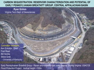
  • 1. CARBON SEQUESTRATION: RESERVOIR CHARACTERIZATION AND POTENTIAL OF EARLY PENNSYLVANIAN BREATHITT GROUP, CENTRAL APPALACHIAN BASIN Ryan Grimm Virginia Tech Dept. of Geosciences Committee members: Ken Eriksson, Chair Fred Read Bill Henika Steve Greb - University of Kentucky Early Pennsylvanian Breathitt Group - Raven and Kennedy coal zone roadcut, Grundy Virginia. USACOE Flood Protection Project.  Vertical height ~100m
  • 2. Carbon Capture and Geological Storage Opportunities in the Pocahontas Basin Objective – Investigate properties of geologic media for long term CO2 storage from a future point source in southwestern Virginia – think FUTUREGEN
  • 3. Paleozoic Reservoirs and Seals of the Pocahontas Basin Study Interval
  • 4. ECBM – ENHANCED COAL BED METHANE RECOVERY AND PRODUCTION USING CO2 FLOODS SECARB estimates 398 million tons of technically feasible ECBM - CO 2 storage capacity in the Pocahontas Basin Potential enhanced recovery of >2.5 TCF of CBM gas production Highlights need for increased understanding of surrounding lithologies Regional shale seals & Additional storage capacities / hazards of porous sandstones
  • 5. Central Appalachian Basin and Pocahontas sub-basin are defined by bounding structures Regional Assessment of Pocahontas sub-basin Adapted from USGS FS2004-3092 and Chesnut, 1994; Greb and Chesnut, 1996; Korus, 2002; Greb et al., 2004; Greb and Martino, 2005 GEOLOGIC SETTING OF POCAHONTAS BASIN ASSESSMENT REGION Extent of Pennsylvanian Strata
  • 6. South Dickenson Strike Line 1-4 DATASET
  • 7. GAMMA RAY SCINTILLOMETRY - FIELD MEASUREMENTS OF LITHOLOGIC RADIOACTIVITY AT GRUNDY
  • 8. Determine Reservoir Parameters – Test porosities and permeabilities of shales and sandstones
  • 9.  
  • 10. STARVED RIPPLES SANDY RHTHYMITES ORGANIC PARTINGS
  • 12. Neonereites Scalarituba Trace Fossil Analysis
  • 13. HENSLEY SHALE – KEY REGIONAL DATUM AND SEAL
  • 14. Raw Data - South Dickenson Strike Line 1
  • 19. - + Sequence Interpretation Basics
  • 21.  
  • 22.
  • 23. THANKS! Katie O’Donnell Bill Rouse Erik Haug Ben Roth David Greenwald Brad Kelley Nino Ripepi Ilija Miskovic