SlideShare uma empresa Scribd logo
1 de 11
For KEN HAMMER MUELLER †
Webster, Minnesota,
who suddenly died
at the age of 50,
April 8, 2013.
THE RATTLESNAKE DISC
(Moundville, Hale County, AL, c.1277 AD)
Dr. R.M. de Jonge ©, drsrmdejonge@hotmail.com
April, 2013
SUMMARY
The Rattlesnake Disc of Moundville, Alabama, tells the story of the Egyptian discovery of
America via the Bering Sea by the 5th king Menkaure of the Fourth Dynasty, and the subse-
quent discoveries of the four Atlantic crossings in the Fifth Dynasty. The Disc shows the pe-
ople of Moundville were ruled according to the ancient Egyptian Sun religion. A survey is
provided of the history of the Empire of Atlantis (c.2500-1200 BC), which consisted of Egypt
with its colonies North and South America. A detailed survey is given of the metal trade du-
ring this period, which included copper from Upper Michigan, tin, silver and gold from Boli-
via, and gold from the River Amazone. Finally, a detailed survey is given of the history of
Egypt until sultan Baibars (1260-1277 AD) of the Mamlukes Sultanate during the Arab Rule.
INTRODUCTION
The town of Moundville, Hale County, is located 25 km south of the city of Tuscaloosa, in the
west of central Alabama, at 33°N. It is well-known from the equally named Archaeological
Site on the east bank of the Black Warrior River. About 28 earthen platform mounds are situ-
ated around a large, rectangular plaza. Its culture flourished between 1200 and 1450 AD, and
it is the second-largest site of the classic Middle Mississippian era, after Cahokia in Illinois.
Some time before 1883 a beautiful Disc was found by a farmer plowing his field. On the front
side a well-engraved design is shown, which represents two entwined or rather knotted Rattle-
snakes (Fig.1). In the center a Hand with an “Eye” is shown. The large, sandstone Disc has a
diameter of 31.9 cm and a thickness of c.1.3 cm. Its circular edge has been devided by small
indentations into 17 segments of about equal length. The Disc is on display in the Jones Ar-
chaeological Museum at the Moundville Archaeological Park. (Refs.1,2)
Fig.1 The Rattlesnake Disc (Moundville, Hale County, AL, c.1277 AD)
DISCOVERY OF AMERICA
The artifact resembles the Sun disc in the sky. So, it appears the whole Disc symbolizes the E-
gyptian SunGod Ra. In the center the “Hand of God” is shown as well as his “All-seeing
Eye”, a well-known Egyptian hieroglyph. - Note, that the back side of a right Hand is shown,
including its finger nails. It appears the Hand tells the well-known story of the Egyptian dis-
covery of America.
The four closed fingers point to the north. So, it appears America was discovered via a north-
ern sailing route in the Fourth Dynasty. The (separate) Thumb points to the northwest. This
fifth finger is in a lower position, which suggests the discovery was accomplished by the 5th
king Menkaure (Mycerinos, c.2580-2562 BC) via the southern Aleutian islands, at the south
side of the Bering Sea (at c.50°N). - The Thumb consists of two parts. So, it appears he re-
turned via the Bering Strait, 15° above these islands. (Refs.3-11)
The five fingers also represent the Fifth Dynasty. The two parts of the Thumb indicate the 2nd
king. So, it appears the 2nd king Sahure (c.2510-2498 BC) of this Dynasty discovered the
southern crossing of the Atlantic, with the wind and the current from West Africa (at 15°N) to
Brazil, as well as the return route from Newfoundland (15° above the site) to the Azores. A
Wrest and a Hand are shown, which confirm this 2nd king discovered two important cros-
sings. The two fingers at the left side confirm it, again.
Besides the Wrest and the Hand the All-seeing Eye is shown. This third item illustrates the
3rd king Neferirkare (c.2498-2478 BC) discovered the third, northern crossing via Greenland.
The three remaining fingers at the right side confirm it. The iris and the five finger nails form
together six, similar symbols. These confirm this crossing, at 60°N.
The Wrest, the Hand, and the All-seeing Eye may symbolize the three island groups of the A-
zores. These consist together of nine islands. Bermuda is located 9° above the holy Tropic of
Cancer, at 23+9= 32°N (Sun religion). So, the return route with the wind and the current from
Bermuda to the Azores was discovered by the 9th and last king Unas (c.2403-2370 BC).
Moundville is located at 33°N, confirming his 33 years of reign.
The iris and the five finger nails are six, similar symbols. These confirm the 3+6= 9th king U-
nas discovered this crossing. The Wrest, the Hand, and the All-seeing Eye illustrate the long
sailing distance: 3 Moiras, or 30°. The four closed fingers confirm all four Atlantic crossings
were discovered in the Fifth Dynasty. The iris and the five finger nails show it all happened
during the six dynasties of the Old Kingdom. (Refs.12-22)
SUN RELIGION
Below the SunGod Ra were two other important gods in the hierarchy: the sungod Horus and
the moongod Osiris. The two main Mounds on the site were probably dedicated to these two
gods. On the Disc they are represented by the two entwined Rattlesnakes. The kings and pha-
raohs were the substitutes of these gods.
The bodies of both snakes consist of three parts: a back, a belly, and a (thin) side (Fig.1). The-
se show this Religion comes from the Nile Delta in Egypt, at 30°N, the same latitude as the
Mississippi Delta. On the back side of the Disc are three marginal incised lines in honor of the
three mentioned Egyptian gods.
Moundville is located at a straight part of the Black Warrior River, having a length of 1 cen-
timoira, or 1.1 km (1 moira= 1°). It points 23° ENE, referring to the holy Tropic of Cancer, at
23°N (Sun religion).
At midsummer day the Sun is there at right angles above. The slow, northerly movement of
the Sun turns into a southerly movement. So, people believe in the Egyptian SunGod Ra. Far
in the east it crosses the River Nile at the center of the Southern Egyptian Empire. However,
this is also the center of the Sun religion.
Besides these gods was Maat, the Egyptian goddess of law and order in the universe. She is
represented by the oval space around the “Hand of God”. She is almost invisible on the Disc,
which resembles her important, but modest position in real life.
King Sahure
The piece of line at the right side of the Wrest runs to the lower half of the snake below it,
which symbolizes the sungod Horus. It has a V pattern on its belly, which refers to the 2nd
king Sahure (two strokes), who turns out to be the substitute of this god. (The fingers of the
Hand point to the belly of the other snake above them, having the same pattern.)
Its head is shown at the right side. His holy words extend over two segments on the edge, as
shown by the waving line from the mouth of the snake. It confirms its substitute: the 2nd king
Sahure. He discovered the two southern crossings of the Ocean.
King Neferirkare
The fingers of the Hand point to the upper half of the snake above them, which symbolizes
the moongod Osiris. It has a zigzag pattern on its back, which refers to the 3rd king Neferir-
kare (a.o. three strokes), who turns out to be the substitute of this god. (The line at the left side
of the Wrest runs downwards to the back of the other snake, having the same pattern.)
Its neck and head are shown at the left side, where the pattern is repeated. His holy words ex-
tend over three segments on the edge, as shown by the waving line from the mouth of the sna-
ke. It confirms its substitute: the 3rd king Neferirkare. He discovered the third, northern cros-
sing.
These two kings
The eyes of both snakes each consist of 2+3= 5 units, which show the 2nd king Sahure and
his successor the 3rd king Neferirkare (both of the Fifth Dynasty) were related to each other.
This is correct, because in ancient Egypt the headlines of government extended over a time
period of two generations (31+30= 61 years). So, the sungod Horus of the first generation
produced the moongod Osiris of the second generation, and this occurred in an endless cycle.
For that reason both snakes are knotted in the shape of a circle, or oval.
The mouths of both snakes each contain six molars, referring to the six dynasties of the Old
Kingdom. The back sides of their necks each have six strokes, confirming it. - The edge of the
Disc is devided into 17 segments, possibly encoding a time period of 17 double generations,
or 17x61= 1037 years, which is more than a millennium. It suggests the secrets on this Disc
guarantee a long and stable Empire, which can last for more than a thousand years.
The tails of both snakes are similar, because both gods Horus and Osiris are equally impor-
tant. However, only the V pattern runs to the very end, which means the 2nd king Sahure (two
strokes) was considered more important than his successor. He discovered two crossings in-
stead of one, and the southern crossing was more important than the northern one. On the ave-
rage 60% of the trade happened via the southern crossing, and 40% via the northern one.
In both cases the tail ends of the Rattlesnakes each finish with four other units (Fig.1), twice
referring to the Fourth Dynasty, when the continents of North and South America were dis-
covered. (Refs.12-22)
CONFIRMATION
The Wrest is situated on the upper half of the snake below it, having four zigzag patterns.
These refer to the discovery of America via the southern Aleutian islands, at the south side of
the Bering Sea, in the Fourth Dynasty. The rectangular plaza on the site in Moundsville has
four equal angles, which refer to this Dynasty.
The fingers on the Disc point to the upper half of the other snake, having five zigzag patterns.
These encode the 5th king Menkaure, who accomplished this discovery, and who returned via
the Bering Strait. - The V patterns above the oval confirm he first discovered the crossing via
the southern Aleutian islands (two strokes). The zigzag patterns above them confirm he dis-
covered the crossing of the Bering Strait afterwards (three strokes).
The five zigzag patterns above the oval now refer to the next, Fifth Dynasty. The V patterns
on the bellies of both snakes refer to the 2nd king Sahure who discovered two southern cros-
sings of the Ocean (two strokes).
The lower half of the tail end at the bottom has a similar pattern, confirming his discovery of
the southern crossing. The fingers of the Hand point to 8 V patterns above them, confirming
his discovery of the return route from Newfoundland to the West Azores over 47-39= 8° of la-
titude.
The fingers point to the upper half of the snake, which has five zigzag signs (three strokes).
These confirm the 3rd king Neferirkare of the Fifth Dynasty, who discovered the northern
crossing of the Ocean at the complementary latitude of the Nile Delta, at 90-30= 60°N. In an-
tiquity the use of complementary latitudes was very common.
These fingers point to the upper half of the snake, which has five vertical strokes, as well. So,
there was also another king of the Fifth Dynasty involved. The Wrest is situated on the back
of the other snake, with four vertical strokes. So, it appears to be the 5+4= 9th king Unas. -
The belly of the snake at the bottom has 9 V patterns, confirming the discovery of the return
route via Bermuda to the nine islands of the Azores by the ninth and last king Unas. (Refs.12-
22)
HISTORY OF ATLANTIS
The Empire of Atlantis consisted of Egypt with its colonies North and South America. The
five fingers point to the upper half of the snake, having five zigzag patterns. These encode the
start of the Empire at the beginning of the Fifth Dynasty. The main Mound at the site was
built at a distance of 5 millimoiras, or 555 m from the River, confirming it. - The two tail ends
on the Disc each contain one zigzag sign, twice encoding the 5+1= 6th Dynasty (c.2373-2189
BC), the last one of the Old Kingdom.
There are 4+5= 9 zigzag signs around the oval. Together with similar signs near the head of
the snake at the left side, and on his tail at the right side, these total to 9+2= 11 signs, referring
to the 11th Dynasty (c.2148-2007 BC), the last one of the First Intermediate Period (FIP).
There are 4+5= 9 zigzag signs around the oval. Together with similar signs near the head of
the snake at the left side and on both tails, these total to 9+3= 12 zigzag patterns, encoding the
Twelfth Dynasty (c.2007-1794 BC, Middle Kingdom). The necks of both snakes each possess
6 strokes, twice encoding the 6 important kings of this Dynasty, and confirming the 6+6=
12th Dynasty. The mouths of both snakes each possess 6 molars, twice confirming these 6
kings, as well as the 6+6= 12th Dynasty, again.
There are 4+5= 9 zigzag signs around the oval. Together with the 8 V signs on the belly of the
snake at the top, these total to 9+8= 17 signs, referring to the 17th Dynasty (c.1611-1580 BC),
the last one of the Second Intermediate Period (SIP).
There are 4+5= 9 zigzag signs around the oval. Together with the 9 V signs on the belly of the
snake at the bottom, these total to 9+9= 18 signs, referring to the Eighteenth Dynasty, the first
one of the New Kingdom.
Central America
However, these 18 signs also refer to the civilization around the south point of the Gulf of
Campeche, Mexico, at 18°N. It is the center of the Land of Punt, which is the “Realm of the
Dead, at the other side of the waters (the Ocean), in the Land where the Sun sets (America)”
(Sun religion). It is the holiest area of the Americas.
It is the center of the Underworld, at a symbolic distance of 18 Moiras, or 180° from the cen-
ter of the Land of the Living (Egypt). This distance corresponds with half the circumference
of the planet Earth, a distance of 36 Moiras, or 360°, as symbolized by the Strait of Gibraltar,
the exit of the Med, at 36°N (Sun religion).
However, above the oval are 8 V signs. Together with the 10+2= 12 zigzag signs (2 of these
at both tail ends), these total to 8+12= 20 signs, encoding the 20th Dynasty (c.1200-1085 BC),
the last one of the New Kingdom (c.1580-1085 BC). It marked the end of the Empire of At-
lantis.
Note, that after the zigzag signs both tail ends have a wound. It means the Old, Middle and
New Kingdoms were finished because of Catastrophic events.
Fig.2 The Rattlesnake Disc (Moundville, Hale County, AL, c.1277 AD)
METAL TRADE
After the discovery of America Egypt founded a stronghold at the south point of the Gulf of
Campeche, Mexico, at 18°N. As indicated above it was done because of religious reasons. –
As soon as they heard of the copper mines in Upper Michigan and the tin mines in Bolivia,
they founded strongholds in these areas, too.
From the start of the 5th Dynasty to the start of the 20th Dynasty (c.2500-1200 BC) America
was a colony of Egypt, together forming the Empire of Atlantis. Both the Old Copper Culture
and the Andes Culture were under Egyptian rule. For the metal trade it meant that law, order
and safety was garanteed by the King of Egypt, back and forth on the Ocean, but also in Ame-
rica itself (political stability).
There are 4+5= 9 zigzag signs around the oval. Together with the 9 V signs on the belly of the
snake at the bottom, these total to 9+9= 18 signs, referring to Isle Royale, Lake Superior, 18°
above the Mississippi Delta, at 30+18= 48°N. It was the center of copper mining in North A-
merica. - It also referred to the present town of Oruro, Bolivia, at 18°S. It was the center of tin
mining in South America.
For a long time past the noble metals were weighed in units of carats, corresponding with 0.20
gram. The carat is the constant mass of a seed of the St. John’s bread or carob tree (Ceratonia si-
liqua). The five fingers of the Hand point to the snake above them, having 8 V signs and five
zigzag patterns. So, the Standard Ingot had a mass of 80,000 carats (a number of five figures), or
80x0.20= 16 kg.
Copper
The five fingers point to the upper half of the snake above them, having five zigzag patterns.
These refer to the 50th latitude line, which runs along the northern bank of the Gulf of Saint
Lawrence, 50-30= 20° above the Mississippi Delta (at 30°N). It shows a fraction of (20/50) or
40% of the copper was transported from Upper Michigan to the Gulf of Saint Lawrence in the
east. The remaining fraction of (30/50) or 60% of the copper was shipped along the Missis-
sippi River to the south.
The tail end at the left side above contains a total of 6+4= 10 units. The lower part has 6 V
signs, confirming the fraction of (6/10) or 60% of the copper shipped to the south. The upper
part finishes with 4 other signs, confirming the fraction of (4/10) or 40% of the copper trans-
ported to the east.
The tail end at the right side below has 4 V signs. After the 20th Dynasty it turned out the o-
verall export was 20+4= 24 million copper ingots, or 24x16= 384 thousand tons of copper.
The eight V signs above the oval show it was a number of eight figures. Both tail ends each
finish with 4 other signs, confirming it, twice.
The 9 V signs at the bottom show all the copper was shipped to the nine islands of the Azores.
These refer to the density of copper, nine times heavier than water. - It has been estimated by
others in the field, that a total amount of 250 to 500 thousand tons of copper had disappeared
from the mining area. So, our conclusion is its destination can now be understood.
Tin
In the Old World bronze was made by alloying the copper with 10% tin. (The words ‘tin’ and
‘ten’ are even related.) There are 9 zigzag signs around the oval. Including the sign in the
neck of the snake at the left side, these total to 9+1= 10 similar signs, confirming this percen-
tage. This neck points southwest, to the direction of Bolivia. - Tin was a very scarce metal.
Although generally unknown, a lot of it was exported from South America.
In the Bronze Age the overall export of tin from the mentioned area was 10% of the copper,
or 2.4 million tin ingots, which is c.38,400 tons of tin. The upper snake has a total of 5+2= 7
zigzag signs, confirming the seven figures of this number. It corresponds with the density of
tin, seven times heavier than water. The tin was transported from Bolivia along the coast to
the north, and from the Pacific to the Atlantic.
Silver
Silver was found together with tin. There are 4+5= 9 zigzag signs around the oval. Together
with the similar sign in the neck of the snake at the left side, these total to 9+1= 10 signs, en-
coding the density of silver, ten times heavier than water. This neck points to the direction of
Bolivia, again.
There are 4+5= 9 zigzag signs around the oval, encoding the overall export of 90 million ca-
rats, or 90x0.20= 18 tons of silver. The eight V signs above the oval show it was a number of
eight figures. Most of the silver in the Old World was imported from Bolivia, in South Ame-
rica.
The 9 zigzag signs around the oval correspond with the Isthmus of Panama, at 9°N, as well as
the nine islands of the Azores. The south point of the Gulf of Campeche, Mexico, is located
18-9= 9° above the Isthmus of Panama, confirming it. The south cape of Florida is located 25-
16= 9° above the north coast of Honduras, confirming it, too.
Gold
Including the sign in the neck of the snake, there are a total of 9+1= 10 zigzag signs around
the oval. Together with the 9 V signs of the belly of the snake at the bottom, these total to
10+9= 19 signs, referring to the more important mining area for tin, silver and gold just east
of Lake of Poopó, near the present town of Potosi, Bolivia, at 19°S.
It also encodes the overall export of gold from Bolivia, 190 million carats, or 190x0.20= 38
tons of gold. It also corresponds with the density of gold, nineteen times heavier than water.
The nine V signs of the belly of the snake at the bottom confirm the nine figures of the num-
ber. The Isthmus of Panama, at 9°N, also confirms these nine figures, as well as the nine is-
lands of the Azores.
The two snakes on the Disc encode the mouth of the Amazon River, where the remaining part
of the gold was traded, 2 Moiras, or 20°, east of the coast of Bolivia, at 2°S. The five fingers
point to the upper half of the snake above them, having five zigzag patterns. These encode the
quantity from this site, 50 million carats (a number of eight figures), or 50x0.20= 10 tons of
gold.
Most of the gold was found near the tin mines of Bolivia. So, the total export of gold was re-
lated to the tin export: 190+50= 240 million carats, or 240x0.20= 48 tons of gold. (The tin ex-
port was 2.4 million ingots; see above.) The diameter / thickness ratio of the Disc equals
31.9/1.3 = 24, confirming the copper, tin and gold export during the Empire of Atlantis. - The
Phaistos Disc of Crete (c.1458 BC) is an important source for this whole story. (Refs.27-35)
HISTORY OF EGYPT
There are 4+5= 9 zigzag signs around the oval, and 8+9= 17 V signs around it, together
9+17= 26 signs, encoding the 26th Dynasty (c.663-525 BC), the last one of the Third Inter-
mediate Period (TIP). The tail at the bottom has 4 V signs, encoding the 26+4= 30st and last
Dynasty (c.378-341 BC), at the end of the so-called “Renewed Independence of Egypt”.
The zigzag sign in the neck of the snake at the left side symbolized the First Persian Rule
(525-404 BC), which coincided with the 27th Dynasty. The similar sign in the tail of this sna-
ke at the right side represents the much later Second Persian Rule (341-333 BC), after the 30st
Dynasty. Finally, the similar sign in the tail of the other snake at the left side above represents
the Macedonian Rule of Egypt (332-304 BC), directly after it.
Ptolemaic Dynasty
The Wrest is situated on the back of the snake below it, having four vertical strokes. These re-
fer to the very successful time period of the Ptolemaic Dynasty (323-30 BC) until Ptolemaeus
IV Philopator (222-205 BC). The 17 segments along the edge of the Disc correspond to his 17
years of reign.
The five vertical strokes on the back of the snake at the top refer to the time period until Pto-
lemaeus IV+V= IX, when Cleopatra III ruled with her son Soter II (116-107 BC). The total
number of nine strokes correspond with his nine years of reign.
The 6 V signs of the tail at the top refer to the last time period of this Dynasty until Ptole-
maeus IX+VI= XV, when Cleopatra VII Philopater ruled with her son Caesarion (51-30 BC).
The 17 segments around the edge devide the circle into equal angles of 360/17= c.21°, confir-
ming their 21 years of reign.
Roman and Byzantine Rule
The neck of the snake at the right side has three X signs, encoding the Roman Rule of Egypt,
which lasted about three centuries (30 BC- c.300 AD). The neck of the snake at the left side
also has three X signs, referring to the Byzantine Rule of the country, which lasted even more
than three centuries (c.300 AD- c.642 AD).
Arab Rule
With the arrival of the Arabs Egypt became an islamic country. Note, that the last segments of
the tail ends are a kind of onions, which resemble the roof of a mosk. Both ends each have
four segments, twice encoding the four important time periods after the Arab Conquest: Egypt
under the Caliphate (642-969), the Fatimids Dynasty (969-1171), the Ayyubid Dynasty
(1171-1249), and the Mamlukes Sultanate (1250-1517). The Wrest is situated on the back of
the snake below it, having four zigzag patterns and four vertical strokes, twice confirming it.
The Ayyubid Dynasty produced three important leaders: sultan Saladin (1174–1193), sultan
Al-Kamil (1218-1238), and sultan Al-Salih (1240-1249). They are represented by the Wrest,
the Hand, and the All-seeing Eye, and they are confirmed by the group of three fingers at the
right side.
Sultan Saladin ruled from 1174 to 1193. Including the sign in the neck of the snake at the left
side, there are a total of 9+1= 10 zigzag signs around the oval. Together with the 9 V signs of
the belly of the snake at the bottom, these total to 10+9= 19 signs, encoding his 19 years of
reign.
Sultan Al-Kamil ruled from 1218 to 1238. Above the oval are 8 V signs. Together with the 12
zigzag signs, these total to 8+12= 20 signs, encoding his 20 years of reign.
Sultan Al-Salih ruled from 1240 to 1249. There are 4+5= 9 zigzag signs around the oval, en-
coding his 9 years of reign.
The last time period of the Mamlukes Sultanate produced two important leaders: sultan Aybak
(1250-1257), and sultan Baibars (1260-1277). They are represented by the Wrest and the
Hand, and they are confirmed by the two remaining fingers at the left side. The five fingers
point to the upper half of the snake above them, which contains five zigzag patterns and five
strokes, twice confirming these 3+2= 5 important rulers.
Sultan Aybak ruled from 1250 to 1257. The upper snake has a total of 5+2= 7 zigzag signs,
encoding his 7 years of reign. - The years of reign of all these Sultans are encoded on the
Disc, because we are dealing here with recent history.
DATE OF THE RATTLESNAKE DISC
The Rattlesnake Disc has two tail ends. So, the most important leader was the second one of
the Mamlukes Sultanate: sultan Baibars (1260-1277). He is represented by the Wrest and the
Hand, and confirmed by the second and last finger at the left side, which is the Thumb. It con-
sists of two parts, confirming this second leader. Both tail ends each finish at the very end
with two tiny strokes, twice confirming it.
Around the oval are 9 zigzag patterns and the fingers point to a series of 8 V signs, which to-
tal to 9+8= 17 signs, confirming his 17 years of reign. The edge of the Disc is devided into 17
segments, strongly confirming it! - It encodes the approximate date of the Rattlesnake Disc at
the end of his reign, which is c.1277. (Refs.36-38)
POPULATION
Archaeologists who studied the site estimate a total population around Moundville of c.10,000
men (Ref.39). - It is probable this figure is somewhere indicated on the Disc. There are 8 V
signs above the oval and 9 V signs below it, which suggest a number of 8,000 or 9,000 men.
However, the Hand clearly points to the top of the oval, which has 5 zigzag patterns and 5
vertical lines, twice suggesting a number of 10,000 men, indeed (a number of 5 figures). The
Hand itself has five fingers and five finger nails, clearly confirming it. It appears the estima-
tion of the mentioned archaeologists is correct: a population of c.10,000 men!
It appears the Disc was made because this population number was recently reached. It was
probably caused by good government, according to the ancient Egyptian Sun religion.
References
1. Wikipedia: http://en.wikipedia.org/wiki/Moundville_Archaeological_Site
2. De Jonge, R.M., “Grave Creek Mound I and II, WV”, Ref.5, to be published.
3. De Jonge, R.M., and Wakefield, J.S., How the SunGod Reached America c.2500 BC, A Guide to Megalithic
Sites, 2002 (ISBN 0-917054-19-9). Available: MCS Inc., Box 3392, Kirkland, Wa 98083, also on CD.
Website: www.howthesungod.com
4. Wakefield, J.S., and De Jonge, R.M., Rocks & Rows, Sailing Routes across the Atlantic and the Copper
Trade, MCS Inc, 2010 (ISBN 0-917054-20-2). Available: MCS Inc, Box 3392, Kirkland, Wa USA 98083.
Website: www.rocksandrows.com
5. De Jonge, R.M., Website: www.slideshare.net/rmdejonge
6. Pellech, Chr., Website: www.migration-diffusion.info
7. De Jonge, R.M., “The Discovery of Three Continents (Santo Stefano, North Sardinia, Italy, c.2300 BC)”, An-
cient American, Vol.12, No.76, pgs.28-29 (2007), Ref.5.
8. De Jonge, R.M., “Houghton’s Petroglyph (Copper Country, Michigan, 2500-1200 BC)” (2009), Ref.5, to be
pu-blished.
9. De Jonge, R.M., “The Mystic Symbol, mark of the Michigan Mound Builders” (2009), Ref.5, to be publish-
ed.
10. De Jonge, R.M., “A Sword for America (Kirkburn, East Yorkshire, England, c.250 BC)” (2009), Ref.5, to be
published.
11. De Jonge, R.M., “The Battersea Shield (River Thames, London, c.190 BC)” (2009), Ref.5, to be published.
12. De Jonge, R.M., and Wakefield, J.S., “Discovery of the Islands in the Ocean (Cairn T, Loughcrew, Co.
Meath, Ireland, c.3200 BC)” (2011), Ref.5, to be published.
13. De Jonge, R.M., and Wakefield, J.S., "The Passage Grave of Karleby, Encoding the Islands Discovered in the
Ocean, c.2950 BC", Migration & Diffusion, Vol.5, No.18, pgs.64-74 (2004), Ref.6.
14. De Jonge, R.M., and Wakefield, J.S., "The Three Rivers Petroglyph, A Guide-post for River Travel in Ame-
rica", Migration & Diffusion, Vol.3, No.12, pgs.74-100 (2002), Ref.6.
15. De Jonge, R.M., and Wakefield, J.S., “A Nautical Center for Crossing the Ocean, America’s Stonehenge,
New Hampshire, c.2200 BC”, Migration & Diffusion, Vol.4, No.15, pgs.60-100 (2003), Ref.6.
16. De Jonge, R.M., “Stonehenge, Monument for the Discovery of America (Salisbury Plain, South England,
c.2000 BC)” (2011), Refs.5,6, to be published.
17. De Jonge, R.M., “Tripod Rock, Pyramid Mountain (Morris County, New Jersey, c.1900 BC)” (2011), Refs.-
5,6, to be published.
18. De Jonge, R.M., “Anglo-Saxon Cemetery Artifacts (Sittingbourne, Kent, SE England, c.650 AD)” (2011),
Refs.5,6, to be published.
19. De Jonge, R.M., “Gold Ring (Grand Canyon, Arizona, c.1450 BC)” (2010), Ref.5, to be published.
20. De Jonge, R.M., “Sentinel Rock, Vermont (Discovery of America and Biblical Flood, c.1900 BC)” (2011),
Refs.5,6, to be published.
21. De Jonge, R.M., “Oil City Glyphs (Pennsylvania, c. 2000 BC)” (2012), Ref.5, to be published.
22. De Jonge, R.M., “The Comet Catastrophe of c.2345 BC”, (sixteen articles),
Webpage: http://www.barry.warmkessel.com/dejonge.html
23. Rydholm, C.F., Michigan Copper, The Untold Story, Winter Cabin Books, Marquette, 2006 (ISBN 0-
9744679-2-8).
24. De Jonge, R.M., “Copper Trade with the Old World (Poverty Point, NE Louisiana)” (2009), Ref. 5, to be pu-
blished.
25. De Jonge, R.M., “Petroglyph of a Sailing Boat (Copper Harbor, Upper Michigan, c.1640 BC)” (2009), Ref.5,
to be published.
26. De Jonge, R.M., “Minoan Pendant (Cleveland, Ohio, c.1690 BC)” (2010), Ref.5, to be published.
27. De Jonge, R.M., The Phaistos Disc Decoded, New Testimony of a Lost Civilization, 300 pgs., Netherlands
(2008). Website: www.slideshare.net/drsrmdejonge
28. De Jonge, R.M., “The Bronze Doors of Rekhmire (Thebes, Upper Egypt, Eighteenth Dynasty, c.1460 BC)”
(2011), Ref.5, to be published.
29. De Jonge, R.M., “The Myths of Monks Mound (Cahokia, Illinois, 650-1400 AD)” (2010), Ref.5, to be
published.
30. De Jonge, R.M., “Cahokia, Capital of Ancient America” (2010), Ref.5, to be published.
31. De Jonge, R.M., “Peters Creek Mound (c.715 BC, Clairton, Pennsylvania)” (2010), Ref.5, to be published.
32. De Jonge, R.M., “Four Ancient Stories (Poverty Point, NE Louisiana, c.700 BC)” (2009), Ref.5, to be pu-
blished.
33. De Jonge, R.M., “Megaliths of Arrowhead Region I (Minnesota, c.1900 BC)” (2012), Ref.5, to be published.
34. De Jonge, R.M., “Megaliths of Arrowhead Region II (Minnesota, c.1900 and c.770 BC BC)” (2012), Ref.5,
to be published.
35. De Jonge, R.M., “Great Serpent Mound (c.2300 BC, Adams County, Ohio)” (2010), Ref.5, to be published.
36. Bailey, J., Sailing to Paradise, Simon & Schuster, 1994 (ISBN 0-684-81297-5).
37. Susan English, Yahoo Group of the Ancient Waterways Society.
38. Robin Mueller, FB Group: “Old Copper Complex and Ancient Waterways America”.
39. University of Alabama website: http://research.ua.edu/2005/12/mighty-mysterious-moundville/

Mais conteúdo relacionado

Semelhante a RATTLESNAKE DISC (MOUNDVILLE, AL)

ali lodhra ppt
ali lodhra pptali lodhra ppt
ali lodhra pptAli Lodhra
 

Semelhante a RATTLESNAKE DISC (MOUNDVILLE, AL) (20)

SERPENT MOUND, OHIO
SERPENT MOUND, OHIOSERPENT MOUND, OHIO
SERPENT MOUND, OHIO
 
ANGLO-SAXON ARTIFACTS
ANGLO-SAXON ARTIFACTSANGLO-SAXON ARTIFACTS
ANGLO-SAXON ARTIFACTS
 
DISCOVERY OF THREE CONTINENTS, SARDINIA
DISCOVERY OF THREE CONTINENTS, SARDINIADISCOVERY OF THREE CONTINENTS, SARDINIA
DISCOVERY OF THREE CONTINENTS, SARDINIA
 
POVERTY POINT, NE LOUISIANA
POVERTY POINT, NE LOUISIANAPOVERTY POINT, NE LOUISIANA
POVERTY POINT, NE LOUISIANA
 
INDIAN ROCK HOUSE, ARKANSAS
INDIAN ROCK HOUSE, ARKANSASINDIAN ROCK HOUSE, ARKANSAS
INDIAN ROCK HOUSE, ARKANSAS
 
A SWORD FOR AMERICA
A SWORD FOR AMERICAA SWORD FOR AMERICA
A SWORD FOR AMERICA
 
CAHOKIA, ILLINOIS
CAHOKIA, ILLINOISCAHOKIA, ILLINOIS
CAHOKIA, ILLINOIS
 
CIRCLE CROSS CARVING, MI
CIRCLE CROSS CARVING, MICIRCLE CROSS CARVING, MI
CIRCLE CROSS CARVING, MI
 
THE BATTERSEA SHIELD (LV)
THE BATTERSEA SHIELD (LV)THE BATTERSEA SHIELD (LV)
THE BATTERSEA SHIELD (LV)
 
DISCOVERY OF AMERICA
DISCOVERY OF AMERICADISCOVERY OF AMERICA
DISCOVERY OF AMERICA
 
BALANCED ROCK (I), ID
BALANCED ROCK (I), IDBALANCED ROCK (I), ID
BALANCED ROCK (I), ID
 
MYSTERY MOUNTAIN (I), WV
MYSTERY MOUNTAIN (I), WVMYSTERY MOUNTAIN (I), WV
MYSTERY MOUNTAIN (I), WV
 
OIL CITY GLYPHS I, PA
OIL CITY GLYPHS I, PAOIL CITY GLYPHS I, PA
OIL CITY GLYPHS I, PA
 
ali lodhra ppt
ali lodhra pptali lodhra ppt
ali lodhra ppt
 
ANCIENT STONE BALLS, MN
ANCIENT STONE BALLS, MNANCIENT STONE BALLS, MN
ANCIENT STONE BALLS, MN
 
Lennox head 5
Lennox head 5Lennox head 5
Lennox head 5
 
GRAVE CREEK MOUND II, WV
GRAVE CREEK MOUND II, WVGRAVE CREEK MOUND II, WV
GRAVE CREEK MOUND II, WV
 
THE BRANDENBURG STONE
THE BRANDENBURG STONETHE BRANDENBURG STONE
THE BRANDENBURG STONE
 
MONKS MOUND, CAHOKIA, ILLINOIS
MONKS MOUND, CAHOKIA, ILLINOISMONKS MOUND, CAHOKIA, ILLINOIS
MONKS MOUND, CAHOKIA, ILLINOIS
 
LONGYOU CAVES, CHINA
LONGYOU CAVES, CHINALONGYOU CAVES, CHINA
LONGYOU CAVES, CHINA
 

Mais de INSTITUTE OF MEGALITHIC RESEARCH

Mais de INSTITUTE OF MEGALITHIC RESEARCH (20)

PREHISTORY OF AZORES (3600-1200 BC)
PREHISTORY OF AZORES (3600-1200 BC)PREHISTORY OF AZORES (3600-1200 BC)
PREHISTORY OF AZORES (3600-1200 BC)
 
EARLY DISCOVERY OF THE WORLD (II)
EARLY DISCOVERY OF THE WORLD (II)EARLY DISCOVERY OF THE WORLD (II)
EARLY DISCOVERY OF THE WORLD (II)
 
EARLY DISCOVERY OF THE WORLD (I)
EARLY DISCOVERY OF THE WORLD (I)EARLY DISCOVERY OF THE WORLD (I)
EARLY DISCOVERY OF THE WORLD (I)
 
SAILING FROM NEW ZEALAND TO AUSTRALIA
SAILING FROM NEW ZEALAND TO AUSTRALIASAILING FROM NEW ZEALAND TO AUSTRALIA
SAILING FROM NEW ZEALAND TO AUSTRALIA
 
MAN OF BACKA, SWEDEN
MAN OF BACKA, SWEDENMAN OF BACKA, SWEDEN
MAN OF BACKA, SWEDEN
 
MYSTERY MOUNTAIN (II), WV
MYSTERY MOUNTAIN (II), WVMYSTERY MOUNTAIN (II), WV
MYSTERY MOUNTAIN (II), WV
 
OMAK ROCK (II), WA
OMAK ROCK (II), WAOMAK ROCK (II), WA
OMAK ROCK (II), WA
 
OMAK ROCK (I), WA
OMAK ROCK (I), WAOMAK ROCK (I), WA
OMAK ROCK (I), WA
 
MEGALITHIC WRITING (II), ORKNEY'S
MEGALITHIC WRITING (II), ORKNEY'SMEGALITHIC WRITING (II), ORKNEY'S
MEGALITHIC WRITING (II), ORKNEY'S
 
MEGALITHIC WRITING (I), ORKNEY'S
MEGALITHIC WRITING (I), ORKNEY'SMEGALITHIC WRITING (I), ORKNEY'S
MEGALITHIC WRITING (I), ORKNEY'S
 
BALANCED ROCK (II), ID
BALANCED ROCK (II), IDBALANCED ROCK (II), ID
BALANCED ROCK (II), ID
 
FOUR CHAMBERS (I), CO
FOUR CHAMBERS (I), COFOUR CHAMBERS (I), CO
FOUR CHAMBERS (I), CO
 
SPHERICAL ROCK, WI
SPHERICAL ROCK, WISPHERICAL ROCK, WI
SPHERICAL ROCK, WI
 
Could it be just a rock?
Could it be just a rock?Could it be just a rock?
Could it be just a rock?
 
COPPER SPEAR TIP, MN
COPPER SPEAR TIP, MNCOPPER SPEAR TIP, MN
COPPER SPEAR TIP, MN
 
GRAVE CREEK MOUND I, WV
GRAVE CREEK MOUND I, WVGRAVE CREEK MOUND I, WV
GRAVE CREEK MOUND I, WV
 
OLD COPPER CULTURE II, MN
OLD COPPER CULTURE II, MNOLD COPPER CULTURE II, MN
OLD COPPER CULTURE II, MN
 
OLD COPPER CULTURE I, MN
OLD COPPER CULTURE I, MNOLD COPPER CULTURE I, MN
OLD COPPER CULTURE I, MN
 
OIL CITY GLYPHS II, PA
OIL CITY GLYPHS II, PAOIL CITY GLYPHS II, PA
OIL CITY GLYPHS II, PA
 
NARRAGANSETT RUNE STONE
NARRAGANSETT RUNE STONENARRAGANSETT RUNE STONE
NARRAGANSETT RUNE STONE
 

Último

Student login on Anyboli platform.helpin
Student login on Anyboli platform.helpinStudent login on Anyboli platform.helpin
Student login on Anyboli platform.helpinRaunakKeshri1
 
Q4-W6-Restating Informational Text Grade 3
Q4-W6-Restating Informational Text Grade 3Q4-W6-Restating Informational Text Grade 3
Q4-W6-Restating Informational Text Grade 3JemimahLaneBuaron
 
POINT- BIOCHEMISTRY SEM 2 ENZYMES UNIT 5.pptx
POINT- BIOCHEMISTRY SEM 2 ENZYMES UNIT 5.pptxPOINT- BIOCHEMISTRY SEM 2 ENZYMES UNIT 5.pptx
POINT- BIOCHEMISTRY SEM 2 ENZYMES UNIT 5.pptxSayali Powar
 
Accessible design: Minimum effort, maximum impact
Accessible design: Minimum effort, maximum impactAccessible design: Minimum effort, maximum impact
Accessible design: Minimum effort, maximum impactdawncurless
 
Privatization and Disinvestment - Meaning, Objectives, Advantages and Disadva...
Privatization and Disinvestment - Meaning, Objectives, Advantages and Disadva...Privatization and Disinvestment - Meaning, Objectives, Advantages and Disadva...
Privatization and Disinvestment - Meaning, Objectives, Advantages and Disadva...RKavithamani
 
SOCIAL AND HISTORICAL CONTEXT - LFTVD.pptx
SOCIAL AND HISTORICAL CONTEXT - LFTVD.pptxSOCIAL AND HISTORICAL CONTEXT - LFTVD.pptx
SOCIAL AND HISTORICAL CONTEXT - LFTVD.pptxiammrhaywood
 
Industrial Policy - 1948, 1956, 1973, 1977, 1980, 1991
Industrial Policy - 1948, 1956, 1973, 1977, 1980, 1991Industrial Policy - 1948, 1956, 1973, 1977, 1980, 1991
Industrial Policy - 1948, 1956, 1973, 1977, 1980, 1991RKavithamani
 
The basics of sentences session 2pptx copy.pptx
The basics of sentences session 2pptx copy.pptxThe basics of sentences session 2pptx copy.pptx
The basics of sentences session 2pptx copy.pptxheathfieldcps1
 
Presentation by Andreas Schleicher Tackling the School Absenteeism Crisis 30 ...
Presentation by Andreas Schleicher Tackling the School Absenteeism Crisis 30 ...Presentation by Andreas Schleicher Tackling the School Absenteeism Crisis 30 ...
Presentation by Andreas Schleicher Tackling the School Absenteeism Crisis 30 ...EduSkills OECD
 
Interactive Powerpoint_How to Master effective communication
Interactive Powerpoint_How to Master effective communicationInteractive Powerpoint_How to Master effective communication
Interactive Powerpoint_How to Master effective communicationnomboosow
 
Nutritional Needs Presentation - HLTH 104
Nutritional Needs Presentation - HLTH 104Nutritional Needs Presentation - HLTH 104
Nutritional Needs Presentation - HLTH 104misteraugie
 
Kisan Call Centre - To harness potential of ICT in Agriculture by answer farm...
Kisan Call Centre - To harness potential of ICT in Agriculture by answer farm...Kisan Call Centre - To harness potential of ICT in Agriculture by answer farm...
Kisan Call Centre - To harness potential of ICT in Agriculture by answer farm...Krashi Coaching
 
The Most Excellent Way | 1 Corinthians 13
The Most Excellent Way | 1 Corinthians 13The Most Excellent Way | 1 Corinthians 13
The Most Excellent Way | 1 Corinthians 13Steve Thomason
 
A Critique of the Proposed National Education Policy Reform
A Critique of the Proposed National Education Policy ReformA Critique of the Proposed National Education Policy Reform
A Critique of the Proposed National Education Policy ReformChameera Dedduwage
 
mini mental status format.docx
mini    mental       status     format.docxmini    mental       status     format.docx
mini mental status format.docxPoojaSen20
 
Call Girls in Dwarka Mor Delhi Contact Us 9654467111
Call Girls in Dwarka Mor Delhi Contact Us 9654467111Call Girls in Dwarka Mor Delhi Contact Us 9654467111
Call Girls in Dwarka Mor Delhi Contact Us 9654467111Sapana Sha
 
BASLIQ CURRENT LOOKBOOK LOOKBOOK(1) (1).pdf
BASLIQ CURRENT LOOKBOOK  LOOKBOOK(1) (1).pdfBASLIQ CURRENT LOOKBOOK  LOOKBOOK(1) (1).pdf
BASLIQ CURRENT LOOKBOOK LOOKBOOK(1) (1).pdfSoniaTolstoy
 

Último (20)

Student login on Anyboli platform.helpin
Student login on Anyboli platform.helpinStudent login on Anyboli platform.helpin
Student login on Anyboli platform.helpin
 
Q4-W6-Restating Informational Text Grade 3
Q4-W6-Restating Informational Text Grade 3Q4-W6-Restating Informational Text Grade 3
Q4-W6-Restating Informational Text Grade 3
 
POINT- BIOCHEMISTRY SEM 2 ENZYMES UNIT 5.pptx
POINT- BIOCHEMISTRY SEM 2 ENZYMES UNIT 5.pptxPOINT- BIOCHEMISTRY SEM 2 ENZYMES UNIT 5.pptx
POINT- BIOCHEMISTRY SEM 2 ENZYMES UNIT 5.pptx
 
Accessible design: Minimum effort, maximum impact
Accessible design: Minimum effort, maximum impactAccessible design: Minimum effort, maximum impact
Accessible design: Minimum effort, maximum impact
 
Privatization and Disinvestment - Meaning, Objectives, Advantages and Disadva...
Privatization and Disinvestment - Meaning, Objectives, Advantages and Disadva...Privatization and Disinvestment - Meaning, Objectives, Advantages and Disadva...
Privatization and Disinvestment - Meaning, Objectives, Advantages and Disadva...
 
Mattingly "AI & Prompt Design: Structured Data, Assistants, & RAG"
Mattingly "AI & Prompt Design: Structured Data, Assistants, & RAG"Mattingly "AI & Prompt Design: Structured Data, Assistants, & RAG"
Mattingly "AI & Prompt Design: Structured Data, Assistants, & RAG"
 
SOCIAL AND HISTORICAL CONTEXT - LFTVD.pptx
SOCIAL AND HISTORICAL CONTEXT - LFTVD.pptxSOCIAL AND HISTORICAL CONTEXT - LFTVD.pptx
SOCIAL AND HISTORICAL CONTEXT - LFTVD.pptx
 
Industrial Policy - 1948, 1956, 1973, 1977, 1980, 1991
Industrial Policy - 1948, 1956, 1973, 1977, 1980, 1991Industrial Policy - 1948, 1956, 1973, 1977, 1980, 1991
Industrial Policy - 1948, 1956, 1973, 1977, 1980, 1991
 
The basics of sentences session 2pptx copy.pptx
The basics of sentences session 2pptx copy.pptxThe basics of sentences session 2pptx copy.pptx
The basics of sentences session 2pptx copy.pptx
 
Staff of Color (SOC) Retention Efforts DDSD
Staff of Color (SOC) Retention Efforts DDSDStaff of Color (SOC) Retention Efforts DDSD
Staff of Color (SOC) Retention Efforts DDSD
 
Presentation by Andreas Schleicher Tackling the School Absenteeism Crisis 30 ...
Presentation by Andreas Schleicher Tackling the School Absenteeism Crisis 30 ...Presentation by Andreas Schleicher Tackling the School Absenteeism Crisis 30 ...
Presentation by Andreas Schleicher Tackling the School Absenteeism Crisis 30 ...
 
Interactive Powerpoint_How to Master effective communication
Interactive Powerpoint_How to Master effective communicationInteractive Powerpoint_How to Master effective communication
Interactive Powerpoint_How to Master effective communication
 
Nutritional Needs Presentation - HLTH 104
Nutritional Needs Presentation - HLTH 104Nutritional Needs Presentation - HLTH 104
Nutritional Needs Presentation - HLTH 104
 
Kisan Call Centre - To harness potential of ICT in Agriculture by answer farm...
Kisan Call Centre - To harness potential of ICT in Agriculture by answer farm...Kisan Call Centre - To harness potential of ICT in Agriculture by answer farm...
Kisan Call Centre - To harness potential of ICT in Agriculture by answer farm...
 
The Most Excellent Way | 1 Corinthians 13
The Most Excellent Way | 1 Corinthians 13The Most Excellent Way | 1 Corinthians 13
The Most Excellent Way | 1 Corinthians 13
 
A Critique of the Proposed National Education Policy Reform
A Critique of the Proposed National Education Policy ReformA Critique of the Proposed National Education Policy Reform
A Critique of the Proposed National Education Policy Reform
 
Código Creativo y Arte de Software | Unidad 1
Código Creativo y Arte de Software | Unidad 1Código Creativo y Arte de Software | Unidad 1
Código Creativo y Arte de Software | Unidad 1
 
mini mental status format.docx
mini    mental       status     format.docxmini    mental       status     format.docx
mini mental status format.docx
 
Call Girls in Dwarka Mor Delhi Contact Us 9654467111
Call Girls in Dwarka Mor Delhi Contact Us 9654467111Call Girls in Dwarka Mor Delhi Contact Us 9654467111
Call Girls in Dwarka Mor Delhi Contact Us 9654467111
 
BASLIQ CURRENT LOOKBOOK LOOKBOOK(1) (1).pdf
BASLIQ CURRENT LOOKBOOK  LOOKBOOK(1) (1).pdfBASLIQ CURRENT LOOKBOOK  LOOKBOOK(1) (1).pdf
BASLIQ CURRENT LOOKBOOK LOOKBOOK(1) (1).pdf
 

RATTLESNAKE DISC (MOUNDVILLE, AL)

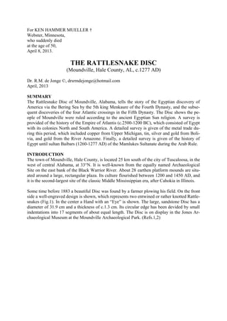
  • 1. For KEN HAMMER MUELLER † Webster, Minnesota, who suddenly died at the age of 50, April 8, 2013. THE RATTLESNAKE DISC (Moundville, Hale County, AL, c.1277 AD) Dr. R.M. de Jonge ©, drsrmdejonge@hotmail.com April, 2013 SUMMARY The Rattlesnake Disc of Moundville, Alabama, tells the story of the Egyptian discovery of America via the Bering Sea by the 5th king Menkaure of the Fourth Dynasty, and the subse- quent discoveries of the four Atlantic crossings in the Fifth Dynasty. The Disc shows the pe- ople of Moundville were ruled according to the ancient Egyptian Sun religion. A survey is provided of the history of the Empire of Atlantis (c.2500-1200 BC), which consisted of Egypt with its colonies North and South America. A detailed survey is given of the metal trade du- ring this period, which included copper from Upper Michigan, tin, silver and gold from Boli- via, and gold from the River Amazone. Finally, a detailed survey is given of the history of Egypt until sultan Baibars (1260-1277 AD) of the Mamlukes Sultanate during the Arab Rule. INTRODUCTION The town of Moundville, Hale County, is located 25 km south of the city of Tuscaloosa, in the west of central Alabama, at 33°N. It is well-known from the equally named Archaeological Site on the east bank of the Black Warrior River. About 28 earthen platform mounds are situ- ated around a large, rectangular plaza. Its culture flourished between 1200 and 1450 AD, and it is the second-largest site of the classic Middle Mississippian era, after Cahokia in Illinois. Some time before 1883 a beautiful Disc was found by a farmer plowing his field. On the front side a well-engraved design is shown, which represents two entwined or rather knotted Rattle- snakes (Fig.1). In the center a Hand with an “Eye” is shown. The large, sandstone Disc has a diameter of 31.9 cm and a thickness of c.1.3 cm. Its circular edge has been devided by small indentations into 17 segments of about equal length. The Disc is on display in the Jones Ar- chaeological Museum at the Moundville Archaeological Park. (Refs.1,2)
  • 2. Fig.1 The Rattlesnake Disc (Moundville, Hale County, AL, c.1277 AD) DISCOVERY OF AMERICA The artifact resembles the Sun disc in the sky. So, it appears the whole Disc symbolizes the E- gyptian SunGod Ra. In the center the “Hand of God” is shown as well as his “All-seeing Eye”, a well-known Egyptian hieroglyph. - Note, that the back side of a right Hand is shown, including its finger nails. It appears the Hand tells the well-known story of the Egyptian dis- covery of America. The four closed fingers point to the north. So, it appears America was discovered via a north- ern sailing route in the Fourth Dynasty. The (separate) Thumb points to the northwest. This fifth finger is in a lower position, which suggests the discovery was accomplished by the 5th king Menkaure (Mycerinos, c.2580-2562 BC) via the southern Aleutian islands, at the south side of the Bering Sea (at c.50°N). - The Thumb consists of two parts. So, it appears he re- turned via the Bering Strait, 15° above these islands. (Refs.3-11) The five fingers also represent the Fifth Dynasty. The two parts of the Thumb indicate the 2nd king. So, it appears the 2nd king Sahure (c.2510-2498 BC) of this Dynasty discovered the southern crossing of the Atlantic, with the wind and the current from West Africa (at 15°N) to Brazil, as well as the return route from Newfoundland (15° above the site) to the Azores. A Wrest and a Hand are shown, which confirm this 2nd king discovered two important cros- sings. The two fingers at the left side confirm it, again. Besides the Wrest and the Hand the All-seeing Eye is shown. This third item illustrates the 3rd king Neferirkare (c.2498-2478 BC) discovered the third, northern crossing via Greenland. The three remaining fingers at the right side confirm it. The iris and the five finger nails form together six, similar symbols. These confirm this crossing, at 60°N.
  • 3. The Wrest, the Hand, and the All-seeing Eye may symbolize the three island groups of the A- zores. These consist together of nine islands. Bermuda is located 9° above the holy Tropic of Cancer, at 23+9= 32°N (Sun religion). So, the return route with the wind and the current from Bermuda to the Azores was discovered by the 9th and last king Unas (c.2403-2370 BC). Moundville is located at 33°N, confirming his 33 years of reign. The iris and the five finger nails are six, similar symbols. These confirm the 3+6= 9th king U- nas discovered this crossing. The Wrest, the Hand, and the All-seeing Eye illustrate the long sailing distance: 3 Moiras, or 30°. The four closed fingers confirm all four Atlantic crossings were discovered in the Fifth Dynasty. The iris and the five finger nails show it all happened during the six dynasties of the Old Kingdom. (Refs.12-22) SUN RELIGION Below the SunGod Ra were two other important gods in the hierarchy: the sungod Horus and the moongod Osiris. The two main Mounds on the site were probably dedicated to these two gods. On the Disc they are represented by the two entwined Rattlesnakes. The kings and pha- raohs were the substitutes of these gods. The bodies of both snakes consist of three parts: a back, a belly, and a (thin) side (Fig.1). The- se show this Religion comes from the Nile Delta in Egypt, at 30°N, the same latitude as the Mississippi Delta. On the back side of the Disc are three marginal incised lines in honor of the three mentioned Egyptian gods. Moundville is located at a straight part of the Black Warrior River, having a length of 1 cen- timoira, or 1.1 km (1 moira= 1°). It points 23° ENE, referring to the holy Tropic of Cancer, at 23°N (Sun religion). At midsummer day the Sun is there at right angles above. The slow, northerly movement of the Sun turns into a southerly movement. So, people believe in the Egyptian SunGod Ra. Far in the east it crosses the River Nile at the center of the Southern Egyptian Empire. However, this is also the center of the Sun religion. Besides these gods was Maat, the Egyptian goddess of law and order in the universe. She is represented by the oval space around the “Hand of God”. She is almost invisible on the Disc, which resembles her important, but modest position in real life. King Sahure The piece of line at the right side of the Wrest runs to the lower half of the snake below it, which symbolizes the sungod Horus. It has a V pattern on its belly, which refers to the 2nd king Sahure (two strokes), who turns out to be the substitute of this god. (The fingers of the Hand point to the belly of the other snake above them, having the same pattern.) Its head is shown at the right side. His holy words extend over two segments on the edge, as shown by the waving line from the mouth of the snake. It confirms its substitute: the 2nd king Sahure. He discovered the two southern crossings of the Ocean. King Neferirkare The fingers of the Hand point to the upper half of the snake above them, which symbolizes the moongod Osiris. It has a zigzag pattern on its back, which refers to the 3rd king Neferir-
  • 4. kare (a.o. three strokes), who turns out to be the substitute of this god. (The line at the left side of the Wrest runs downwards to the back of the other snake, having the same pattern.) Its neck and head are shown at the left side, where the pattern is repeated. His holy words ex- tend over three segments on the edge, as shown by the waving line from the mouth of the sna- ke. It confirms its substitute: the 3rd king Neferirkare. He discovered the third, northern cros- sing. These two kings The eyes of both snakes each consist of 2+3= 5 units, which show the 2nd king Sahure and his successor the 3rd king Neferirkare (both of the Fifth Dynasty) were related to each other. This is correct, because in ancient Egypt the headlines of government extended over a time period of two generations (31+30= 61 years). So, the sungod Horus of the first generation produced the moongod Osiris of the second generation, and this occurred in an endless cycle. For that reason both snakes are knotted in the shape of a circle, or oval. The mouths of both snakes each contain six molars, referring to the six dynasties of the Old Kingdom. The back sides of their necks each have six strokes, confirming it. - The edge of the Disc is devided into 17 segments, possibly encoding a time period of 17 double generations, or 17x61= 1037 years, which is more than a millennium. It suggests the secrets on this Disc guarantee a long and stable Empire, which can last for more than a thousand years. The tails of both snakes are similar, because both gods Horus and Osiris are equally impor- tant. However, only the V pattern runs to the very end, which means the 2nd king Sahure (two strokes) was considered more important than his successor. He discovered two crossings in- stead of one, and the southern crossing was more important than the northern one. On the ave- rage 60% of the trade happened via the southern crossing, and 40% via the northern one. In both cases the tail ends of the Rattlesnakes each finish with four other units (Fig.1), twice referring to the Fourth Dynasty, when the continents of North and South America were dis- covered. (Refs.12-22) CONFIRMATION The Wrest is situated on the upper half of the snake below it, having four zigzag patterns. These refer to the discovery of America via the southern Aleutian islands, at the south side of the Bering Sea, in the Fourth Dynasty. The rectangular plaza on the site in Moundsville has four equal angles, which refer to this Dynasty. The fingers on the Disc point to the upper half of the other snake, having five zigzag patterns. These encode the 5th king Menkaure, who accomplished this discovery, and who returned via the Bering Strait. - The V patterns above the oval confirm he first discovered the crossing via the southern Aleutian islands (two strokes). The zigzag patterns above them confirm he dis- covered the crossing of the Bering Strait afterwards (three strokes). The five zigzag patterns above the oval now refer to the next, Fifth Dynasty. The V patterns on the bellies of both snakes refer to the 2nd king Sahure who discovered two southern cros- sings of the Ocean (two strokes). The lower half of the tail end at the bottom has a similar pattern, confirming his discovery of the southern crossing. The fingers of the Hand point to 8 V patterns above them, confirming
  • 5. his discovery of the return route from Newfoundland to the West Azores over 47-39= 8° of la- titude. The fingers point to the upper half of the snake, which has five zigzag signs (three strokes). These confirm the 3rd king Neferirkare of the Fifth Dynasty, who discovered the northern crossing of the Ocean at the complementary latitude of the Nile Delta, at 90-30= 60°N. In an- tiquity the use of complementary latitudes was very common. These fingers point to the upper half of the snake, which has five vertical strokes, as well. So, there was also another king of the Fifth Dynasty involved. The Wrest is situated on the back of the other snake, with four vertical strokes. So, it appears to be the 5+4= 9th king Unas. - The belly of the snake at the bottom has 9 V patterns, confirming the discovery of the return route via Bermuda to the nine islands of the Azores by the ninth and last king Unas. (Refs.12- 22) HISTORY OF ATLANTIS The Empire of Atlantis consisted of Egypt with its colonies North and South America. The five fingers point to the upper half of the snake, having five zigzag patterns. These encode the start of the Empire at the beginning of the Fifth Dynasty. The main Mound at the site was built at a distance of 5 millimoiras, or 555 m from the River, confirming it. - The two tail ends on the Disc each contain one zigzag sign, twice encoding the 5+1= 6th Dynasty (c.2373-2189 BC), the last one of the Old Kingdom. There are 4+5= 9 zigzag signs around the oval. Together with similar signs near the head of the snake at the left side, and on his tail at the right side, these total to 9+2= 11 signs, referring to the 11th Dynasty (c.2148-2007 BC), the last one of the First Intermediate Period (FIP). There are 4+5= 9 zigzag signs around the oval. Together with similar signs near the head of the snake at the left side and on both tails, these total to 9+3= 12 zigzag patterns, encoding the Twelfth Dynasty (c.2007-1794 BC, Middle Kingdom). The necks of both snakes each possess 6 strokes, twice encoding the 6 important kings of this Dynasty, and confirming the 6+6= 12th Dynasty. The mouths of both snakes each possess 6 molars, twice confirming these 6 kings, as well as the 6+6= 12th Dynasty, again. There are 4+5= 9 zigzag signs around the oval. Together with the 8 V signs on the belly of the snake at the top, these total to 9+8= 17 signs, referring to the 17th Dynasty (c.1611-1580 BC), the last one of the Second Intermediate Period (SIP). There are 4+5= 9 zigzag signs around the oval. Together with the 9 V signs on the belly of the snake at the bottom, these total to 9+9= 18 signs, referring to the Eighteenth Dynasty, the first one of the New Kingdom. Central America However, these 18 signs also refer to the civilization around the south point of the Gulf of Campeche, Mexico, at 18°N. It is the center of the Land of Punt, which is the “Realm of the Dead, at the other side of the waters (the Ocean), in the Land where the Sun sets (America)” (Sun religion). It is the holiest area of the Americas. It is the center of the Underworld, at a symbolic distance of 18 Moiras, or 180° from the cen- ter of the Land of the Living (Egypt). This distance corresponds with half the circumference
  • 6. of the planet Earth, a distance of 36 Moiras, or 360°, as symbolized by the Strait of Gibraltar, the exit of the Med, at 36°N (Sun religion). However, above the oval are 8 V signs. Together with the 10+2= 12 zigzag signs (2 of these at both tail ends), these total to 8+12= 20 signs, encoding the 20th Dynasty (c.1200-1085 BC), the last one of the New Kingdom (c.1580-1085 BC). It marked the end of the Empire of At- lantis. Note, that after the zigzag signs both tail ends have a wound. It means the Old, Middle and New Kingdoms were finished because of Catastrophic events. Fig.2 The Rattlesnake Disc (Moundville, Hale County, AL, c.1277 AD) METAL TRADE After the discovery of America Egypt founded a stronghold at the south point of the Gulf of Campeche, Mexico, at 18°N. As indicated above it was done because of religious reasons. – As soon as they heard of the copper mines in Upper Michigan and the tin mines in Bolivia, they founded strongholds in these areas, too. From the start of the 5th Dynasty to the start of the 20th Dynasty (c.2500-1200 BC) America was a colony of Egypt, together forming the Empire of Atlantis. Both the Old Copper Culture and the Andes Culture were under Egyptian rule. For the metal trade it meant that law, order and safety was garanteed by the King of Egypt, back and forth on the Ocean, but also in Ame- rica itself (political stability). There are 4+5= 9 zigzag signs around the oval. Together with the 9 V signs on the belly of the snake at the bottom, these total to 9+9= 18 signs, referring to Isle Royale, Lake Superior, 18° above the Mississippi Delta, at 30+18= 48°N. It was the center of copper mining in North A-
  • 7. merica. - It also referred to the present town of Oruro, Bolivia, at 18°S. It was the center of tin mining in South America. For a long time past the noble metals were weighed in units of carats, corresponding with 0.20 gram. The carat is the constant mass of a seed of the St. John’s bread or carob tree (Ceratonia si- liqua). The five fingers of the Hand point to the snake above them, having 8 V signs and five zigzag patterns. So, the Standard Ingot had a mass of 80,000 carats (a number of five figures), or 80x0.20= 16 kg. Copper The five fingers point to the upper half of the snake above them, having five zigzag patterns. These refer to the 50th latitude line, which runs along the northern bank of the Gulf of Saint Lawrence, 50-30= 20° above the Mississippi Delta (at 30°N). It shows a fraction of (20/50) or 40% of the copper was transported from Upper Michigan to the Gulf of Saint Lawrence in the east. The remaining fraction of (30/50) or 60% of the copper was shipped along the Missis- sippi River to the south. The tail end at the left side above contains a total of 6+4= 10 units. The lower part has 6 V signs, confirming the fraction of (6/10) or 60% of the copper shipped to the south. The upper part finishes with 4 other signs, confirming the fraction of (4/10) or 40% of the copper trans- ported to the east. The tail end at the right side below has 4 V signs. After the 20th Dynasty it turned out the o- verall export was 20+4= 24 million copper ingots, or 24x16= 384 thousand tons of copper. The eight V signs above the oval show it was a number of eight figures. Both tail ends each finish with 4 other signs, confirming it, twice. The 9 V signs at the bottom show all the copper was shipped to the nine islands of the Azores. These refer to the density of copper, nine times heavier than water. - It has been estimated by others in the field, that a total amount of 250 to 500 thousand tons of copper had disappeared from the mining area. So, our conclusion is its destination can now be understood. Tin In the Old World bronze was made by alloying the copper with 10% tin. (The words ‘tin’ and ‘ten’ are even related.) There are 9 zigzag signs around the oval. Including the sign in the neck of the snake at the left side, these total to 9+1= 10 similar signs, confirming this percen- tage. This neck points southwest, to the direction of Bolivia. - Tin was a very scarce metal. Although generally unknown, a lot of it was exported from South America. In the Bronze Age the overall export of tin from the mentioned area was 10% of the copper, or 2.4 million tin ingots, which is c.38,400 tons of tin. The upper snake has a total of 5+2= 7 zigzag signs, confirming the seven figures of this number. It corresponds with the density of tin, seven times heavier than water. The tin was transported from Bolivia along the coast to the north, and from the Pacific to the Atlantic. Silver Silver was found together with tin. There are 4+5= 9 zigzag signs around the oval. Together with the similar sign in the neck of the snake at the left side, these total to 9+1= 10 signs, en- coding the density of silver, ten times heavier than water. This neck points to the direction of Bolivia, again.
  • 8. There are 4+5= 9 zigzag signs around the oval, encoding the overall export of 90 million ca- rats, or 90x0.20= 18 tons of silver. The eight V signs above the oval show it was a number of eight figures. Most of the silver in the Old World was imported from Bolivia, in South Ame- rica. The 9 zigzag signs around the oval correspond with the Isthmus of Panama, at 9°N, as well as the nine islands of the Azores. The south point of the Gulf of Campeche, Mexico, is located 18-9= 9° above the Isthmus of Panama, confirming it. The south cape of Florida is located 25- 16= 9° above the north coast of Honduras, confirming it, too. Gold Including the sign in the neck of the snake, there are a total of 9+1= 10 zigzag signs around the oval. Together with the 9 V signs of the belly of the snake at the bottom, these total to 10+9= 19 signs, referring to the more important mining area for tin, silver and gold just east of Lake of Poopó, near the present town of Potosi, Bolivia, at 19°S. It also encodes the overall export of gold from Bolivia, 190 million carats, or 190x0.20= 38 tons of gold. It also corresponds with the density of gold, nineteen times heavier than water. The nine V signs of the belly of the snake at the bottom confirm the nine figures of the num- ber. The Isthmus of Panama, at 9°N, also confirms these nine figures, as well as the nine is- lands of the Azores. The two snakes on the Disc encode the mouth of the Amazon River, where the remaining part of the gold was traded, 2 Moiras, or 20°, east of the coast of Bolivia, at 2°S. The five fingers point to the upper half of the snake above them, having five zigzag patterns. These encode the quantity from this site, 50 million carats (a number of eight figures), or 50x0.20= 10 tons of gold. Most of the gold was found near the tin mines of Bolivia. So, the total export of gold was re- lated to the tin export: 190+50= 240 million carats, or 240x0.20= 48 tons of gold. (The tin ex- port was 2.4 million ingots; see above.) The diameter / thickness ratio of the Disc equals 31.9/1.3 = 24, confirming the copper, tin and gold export during the Empire of Atlantis. - The Phaistos Disc of Crete (c.1458 BC) is an important source for this whole story. (Refs.27-35) HISTORY OF EGYPT There are 4+5= 9 zigzag signs around the oval, and 8+9= 17 V signs around it, together 9+17= 26 signs, encoding the 26th Dynasty (c.663-525 BC), the last one of the Third Inter- mediate Period (TIP). The tail at the bottom has 4 V signs, encoding the 26+4= 30st and last Dynasty (c.378-341 BC), at the end of the so-called “Renewed Independence of Egypt”. The zigzag sign in the neck of the snake at the left side symbolized the First Persian Rule (525-404 BC), which coincided with the 27th Dynasty. The similar sign in the tail of this sna- ke at the right side represents the much later Second Persian Rule (341-333 BC), after the 30st Dynasty. Finally, the similar sign in the tail of the other snake at the left side above represents the Macedonian Rule of Egypt (332-304 BC), directly after it. Ptolemaic Dynasty The Wrest is situated on the back of the snake below it, having four vertical strokes. These re- fer to the very successful time period of the Ptolemaic Dynasty (323-30 BC) until Ptolemaeus
  • 9. IV Philopator (222-205 BC). The 17 segments along the edge of the Disc correspond to his 17 years of reign. The five vertical strokes on the back of the snake at the top refer to the time period until Pto- lemaeus IV+V= IX, when Cleopatra III ruled with her son Soter II (116-107 BC). The total number of nine strokes correspond with his nine years of reign. The 6 V signs of the tail at the top refer to the last time period of this Dynasty until Ptole- maeus IX+VI= XV, when Cleopatra VII Philopater ruled with her son Caesarion (51-30 BC). The 17 segments around the edge devide the circle into equal angles of 360/17= c.21°, confir- ming their 21 years of reign. Roman and Byzantine Rule The neck of the snake at the right side has three X signs, encoding the Roman Rule of Egypt, which lasted about three centuries (30 BC- c.300 AD). The neck of the snake at the left side also has three X signs, referring to the Byzantine Rule of the country, which lasted even more than three centuries (c.300 AD- c.642 AD). Arab Rule With the arrival of the Arabs Egypt became an islamic country. Note, that the last segments of the tail ends are a kind of onions, which resemble the roof of a mosk. Both ends each have four segments, twice encoding the four important time periods after the Arab Conquest: Egypt under the Caliphate (642-969), the Fatimids Dynasty (969-1171), the Ayyubid Dynasty (1171-1249), and the Mamlukes Sultanate (1250-1517). The Wrest is situated on the back of the snake below it, having four zigzag patterns and four vertical strokes, twice confirming it. The Ayyubid Dynasty produced three important leaders: sultan Saladin (1174–1193), sultan Al-Kamil (1218-1238), and sultan Al-Salih (1240-1249). They are represented by the Wrest, the Hand, and the All-seeing Eye, and they are confirmed by the group of three fingers at the right side. Sultan Saladin ruled from 1174 to 1193. Including the sign in the neck of the snake at the left side, there are a total of 9+1= 10 zigzag signs around the oval. Together with the 9 V signs of the belly of the snake at the bottom, these total to 10+9= 19 signs, encoding his 19 years of reign. Sultan Al-Kamil ruled from 1218 to 1238. Above the oval are 8 V signs. Together with the 12 zigzag signs, these total to 8+12= 20 signs, encoding his 20 years of reign. Sultan Al-Salih ruled from 1240 to 1249. There are 4+5= 9 zigzag signs around the oval, en- coding his 9 years of reign. The last time period of the Mamlukes Sultanate produced two important leaders: sultan Aybak (1250-1257), and sultan Baibars (1260-1277). They are represented by the Wrest and the Hand, and they are confirmed by the two remaining fingers at the left side. The five fingers point to the upper half of the snake above them, which contains five zigzag patterns and five strokes, twice confirming these 3+2= 5 important rulers. Sultan Aybak ruled from 1250 to 1257. The upper snake has a total of 5+2= 7 zigzag signs, encoding his 7 years of reign. - The years of reign of all these Sultans are encoded on the Disc, because we are dealing here with recent history.
  • 10. DATE OF THE RATTLESNAKE DISC The Rattlesnake Disc has two tail ends. So, the most important leader was the second one of the Mamlukes Sultanate: sultan Baibars (1260-1277). He is represented by the Wrest and the Hand, and confirmed by the second and last finger at the left side, which is the Thumb. It con- sists of two parts, confirming this second leader. Both tail ends each finish at the very end with two tiny strokes, twice confirming it. Around the oval are 9 zigzag patterns and the fingers point to a series of 8 V signs, which to- tal to 9+8= 17 signs, confirming his 17 years of reign. The edge of the Disc is devided into 17 segments, strongly confirming it! - It encodes the approximate date of the Rattlesnake Disc at the end of his reign, which is c.1277. (Refs.36-38) POPULATION Archaeologists who studied the site estimate a total population around Moundville of c.10,000 men (Ref.39). - It is probable this figure is somewhere indicated on the Disc. There are 8 V signs above the oval and 9 V signs below it, which suggest a number of 8,000 or 9,000 men. However, the Hand clearly points to the top of the oval, which has 5 zigzag patterns and 5 vertical lines, twice suggesting a number of 10,000 men, indeed (a number of 5 figures). The Hand itself has five fingers and five finger nails, clearly confirming it. It appears the estima- tion of the mentioned archaeologists is correct: a population of c.10,000 men! It appears the Disc was made because this population number was recently reached. It was probably caused by good government, according to the ancient Egyptian Sun religion. References 1. Wikipedia: http://en.wikipedia.org/wiki/Moundville_Archaeological_Site 2. De Jonge, R.M., “Grave Creek Mound I and II, WV”, Ref.5, to be published. 3. De Jonge, R.M., and Wakefield, J.S., How the SunGod Reached America c.2500 BC, A Guide to Megalithic Sites, 2002 (ISBN 0-917054-19-9). Available: MCS Inc., Box 3392, Kirkland, Wa 98083, also on CD. Website: www.howthesungod.com 4. Wakefield, J.S., and De Jonge, R.M., Rocks & Rows, Sailing Routes across the Atlantic and the Copper Trade, MCS Inc, 2010 (ISBN 0-917054-20-2). Available: MCS Inc, Box 3392, Kirkland, Wa USA 98083. Website: www.rocksandrows.com 5. De Jonge, R.M., Website: www.slideshare.net/rmdejonge 6. Pellech, Chr., Website: www.migration-diffusion.info 7. De Jonge, R.M., “The Discovery of Three Continents (Santo Stefano, North Sardinia, Italy, c.2300 BC)”, An- cient American, Vol.12, No.76, pgs.28-29 (2007), Ref.5. 8. De Jonge, R.M., “Houghton’s Petroglyph (Copper Country, Michigan, 2500-1200 BC)” (2009), Ref.5, to be pu-blished. 9. De Jonge, R.M., “The Mystic Symbol, mark of the Michigan Mound Builders” (2009), Ref.5, to be publish- ed. 10. De Jonge, R.M., “A Sword for America (Kirkburn, East Yorkshire, England, c.250 BC)” (2009), Ref.5, to be published. 11. De Jonge, R.M., “The Battersea Shield (River Thames, London, c.190 BC)” (2009), Ref.5, to be published. 12. De Jonge, R.M., and Wakefield, J.S., “Discovery of the Islands in the Ocean (Cairn T, Loughcrew, Co. Meath, Ireland, c.3200 BC)” (2011), Ref.5, to be published. 13. De Jonge, R.M., and Wakefield, J.S., "The Passage Grave of Karleby, Encoding the Islands Discovered in the Ocean, c.2950 BC", Migration & Diffusion, Vol.5, No.18, pgs.64-74 (2004), Ref.6. 14. De Jonge, R.M., and Wakefield, J.S., "The Three Rivers Petroglyph, A Guide-post for River Travel in Ame- rica", Migration & Diffusion, Vol.3, No.12, pgs.74-100 (2002), Ref.6. 15. De Jonge, R.M., and Wakefield, J.S., “A Nautical Center for Crossing the Ocean, America’s Stonehenge, New Hampshire, c.2200 BC”, Migration & Diffusion, Vol.4, No.15, pgs.60-100 (2003), Ref.6. 16. De Jonge, R.M., “Stonehenge, Monument for the Discovery of America (Salisbury Plain, South England, c.2000 BC)” (2011), Refs.5,6, to be published.
  • 11. 17. De Jonge, R.M., “Tripod Rock, Pyramid Mountain (Morris County, New Jersey, c.1900 BC)” (2011), Refs.- 5,6, to be published. 18. De Jonge, R.M., “Anglo-Saxon Cemetery Artifacts (Sittingbourne, Kent, SE England, c.650 AD)” (2011), Refs.5,6, to be published. 19. De Jonge, R.M., “Gold Ring (Grand Canyon, Arizona, c.1450 BC)” (2010), Ref.5, to be published. 20. De Jonge, R.M., “Sentinel Rock, Vermont (Discovery of America and Biblical Flood, c.1900 BC)” (2011), Refs.5,6, to be published. 21. De Jonge, R.M., “Oil City Glyphs (Pennsylvania, c. 2000 BC)” (2012), Ref.5, to be published. 22. De Jonge, R.M., “The Comet Catastrophe of c.2345 BC”, (sixteen articles), Webpage: http://www.barry.warmkessel.com/dejonge.html 23. Rydholm, C.F., Michigan Copper, The Untold Story, Winter Cabin Books, Marquette, 2006 (ISBN 0- 9744679-2-8). 24. De Jonge, R.M., “Copper Trade with the Old World (Poverty Point, NE Louisiana)” (2009), Ref. 5, to be pu- blished. 25. De Jonge, R.M., “Petroglyph of a Sailing Boat (Copper Harbor, Upper Michigan, c.1640 BC)” (2009), Ref.5, to be published. 26. De Jonge, R.M., “Minoan Pendant (Cleveland, Ohio, c.1690 BC)” (2010), Ref.5, to be published. 27. De Jonge, R.M., The Phaistos Disc Decoded, New Testimony of a Lost Civilization, 300 pgs., Netherlands (2008). Website: www.slideshare.net/drsrmdejonge 28. De Jonge, R.M., “The Bronze Doors of Rekhmire (Thebes, Upper Egypt, Eighteenth Dynasty, c.1460 BC)” (2011), Ref.5, to be published. 29. De Jonge, R.M., “The Myths of Monks Mound (Cahokia, Illinois, 650-1400 AD)” (2010), Ref.5, to be published. 30. De Jonge, R.M., “Cahokia, Capital of Ancient America” (2010), Ref.5, to be published. 31. De Jonge, R.M., “Peters Creek Mound (c.715 BC, Clairton, Pennsylvania)” (2010), Ref.5, to be published. 32. De Jonge, R.M., “Four Ancient Stories (Poverty Point, NE Louisiana, c.700 BC)” (2009), Ref.5, to be pu- blished. 33. De Jonge, R.M., “Megaliths of Arrowhead Region I (Minnesota, c.1900 BC)” (2012), Ref.5, to be published. 34. De Jonge, R.M., “Megaliths of Arrowhead Region II (Minnesota, c.1900 and c.770 BC BC)” (2012), Ref.5, to be published. 35. De Jonge, R.M., “Great Serpent Mound (c.2300 BC, Adams County, Ohio)” (2010), Ref.5, to be published. 36. Bailey, J., Sailing to Paradise, Simon & Schuster, 1994 (ISBN 0-684-81297-5). 37. Susan English, Yahoo Group of the Ancient Waterways Society. 38. Robin Mueller, FB Group: “Old Copper Complex and Ancient Waterways America”. 39. University of Alabama website: http://research.ua.edu/2005/12/mighty-mysterious-moundville/