
Recomendados
Mais conteúdo relacionado
Mais procurados
Mais procurados (20)
Semelhante a ARANYA LOW COST HOUSING PROJECT
Semelhante a ARANYA LOW COST HOUSING PROJECT (20)
Último
Último (20)
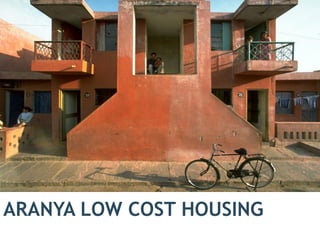
ARANYA LOW COST HOUSING PROJECT
- 1. ARANYA LOW COST HOUSING 1
- 2. INTRODUCTION • Aranya is a housing project of Indore Development Authority(IDA) primarily serving the EWS and other income groups. • In 1983, the VastuShilpa Foundation was entrusted with preparing a master plan for the development of a new township in Aranya. • Aranya is a low income housing settlement conceived as a six self contained neighborhoods, each incorporating facilities such as schools, medical centres and shops.the complex provides housing for over 6500 families. • It is situated on the Delhi-Bombay highway, six kilometres from the centre of Indore. • ABOUT: LOCATION : Aranya Nagar, Vijay Nagar, Indore ARCHITECT:B.V Doshi , Vastu Shilpa Foundation YEAR OF COMPLETION: 1989 SITE AREA: 85 hectares(210 acre)
- 3. LOCATION INDORE ARANYA NAGAR (85 HECTARES TOWNSHIP) LOCATION OF ARANYA NAGAR
- 4. SITE ACCESSIBILITY: • ROADWAYS: Connected to the delhi-Bombay highway. • RAILWAY STATION:indore junction-8km • AIRPORT: devi ahilya bai holkar airport- 14 km HOSPITAL: • Vedant hospital – 1.2 km • Synergy hospital -1.1 km SCHOOL: • St.Arnold H.S School – 1 km MARKET • Hatti super market- 1.2 km GARDEN : • Shehnai garden is connected with the complex NEAREST RIVER: saraswati river ARANYA NAGAR LOCATION PLAN OF THE SITE
- 5. ABOUT THE SITE Aranya Housing consists of residential,commercial, institutional spaces that makes a complete Township • AREA OF THE PROJECT: 85 Hectares (210 acre) • POPULATION: 65000 • TOTAL NUMBER OF PLOTS: 6500 • ENTRY/EXITS: The site is accessible from Agra Bombay highway towards east(60M road)and the main road(30M road)towards north. MAIN ROAD MAIN ROAD Site plan of the Aranya Township
- 6. DEVELOPMENT OF THE PLAN 6 Plan prepared by the IDA which was without any open space hierarchy, circulation systems and climatic considerations Initial stage of the proposed plan with distributed open spaces and street hierarchy Later stage plan with rectified orientation to decrease heat gain and increase natural shading Proposed master plan with interlinked open spaces,builtform,dis tributed amenities , road hierarchy and climate friendly STAGE 1 STAGE 2 STAGE 3 STAGE 4
- 7. SITE PLANNING •The site is divided into six parts by the roads •Each part/sector has residential clusters,community spaces,a set of road networks and services and green spaces •Each sector has residential clusters of majorly 4 types of housing groups: 1. EWS 2. LIG 3. MIG 4. HIG • The central spine area is meant for the commercial and institutional land use. Plan showing the division of the sectors via road network N
- 8. LAND USE AREA(IN HECTARES) PERCE NTAGE Net planning area 86.24 100 Residential area 50.17 58.17 Shopping/ commercia l centers 2.8 3.25 School and communit y 5.8 6.7 Road area 20.29 23.52 Open spaces • Public area • Service slots 6 1.5 =7.5 6.8 1.33 =8.16 LAND USE RESIDENTIAL COMMERCIAL+INSTITUTIONAL GREEN AREA Plan indicating the zoning of the site
- 9. ROAD CONNECTIVITY :Town level 60 M 30M 12M 9.5M 4.5M 1.5M 15M TYPES OF ROAD SYSTEMS • 60M :it is the metaled national highway on east, connecting the site to Indore city. • 30M : it is the metaled city road forming the boundary on the north, south and east of the site. • 15M:the central spine road linking the town center to the other parts of Aranya. The road connects the 30m road on the north and the south • 12M : it is forming the boundary of the six sectors of township. • 9.5M: the stone paved access road to blocks from sector road to plot. • 4.5M: stone paved internal streets in front of the plots. • 1.5M: stone paved pedestrian path in green area.Plan: road typology
- 10. 10 ROAD CONNECTIVITY :Sector level 30M 12M 15M 9.5M 4.5M 1.5M • Each sector is surrounded by the 12M road . • The 9M road further divides the sector into small clusters of EWS,LIG,MIG and HIG housing groups. • The LIG,MIG and HIG are located along 12M and 9M roads while the EWS are located along 4.5M roads Sketch showing the connectivity of the green spaces with the roads Plan: road typology of a sector
- 11. ROAD CONNECTIVITY: cluster level(EWS) 4.5M 1.5M 9.5M the green spaces in between the blocks. These are linked to central spine by green spaces that are used by the communities . The cul-de-sacs at every cluster is the same. The service cores are present in between the clusters that can be used for communal activities The walkways running along the green spaces meet the 4.5m road at the cul de sac square A secondary stepped pathway runs along the 4.5m road allowing the pedestrians to access the house. Thus the vehicular and the pedestrian movement are segregated. 1.5M walkway Stepped pathway house Plan: cluster level roads Detail at
- 12. THE 4.5 M ROAD IN FRONT OF THE PLOTS THE PEDESTRIAN WALKWAYS IN BETWEEN GREEN SPACES(1.5M road)
- 13. HOUSING TYPOLOGY AT ARANYA EWS 1,2,3 4262 PLOTS= 65.1% PLOT AREA=35-45M SQ LIG 1,2,3 1095 PLOTS=16.7% PLOT AREA=55-95 MSQ MIG 1,2 891 PLOTS=13.5 % PLOT AREA= 140-220M SQ HIG 1,2 255 PLOTS=4.4% PLOT AREA= 325-450 MSQ FLATS 40 PLOTS=0.5% PLOT AREA=618M SQ GREEN AREA COMMERCIAL+INSTITUTIONAL Plan :Housing typology
- 14. HOUSING TYPOLOGY FOR EWS GROUP The house basically consists of a verandah ,2 rooms,kitchen and the main service core-toilet and the bathroom The types only differ by the number of floors and the types of the stairs
- 15. PLANNING OF THE UNITS • The major house plans included a verandah(otla),a living room,followed by a kitchen.The toilets were provided at back of the house. • Most houses were provided with an additional access at the back,that allowed them to keep animals,a vehicle or even renting out that part of the house for income. • ten houses formed a cluster that opened into a street. • The courtyard at the back opened into the open space of the cluster and was used as a play area and service area.
- 16. 16 1 2 4 5 6 7 8 9 3 PLANNING OF THE CLUSTERS PLAN OF EWS CLUSTERS PLAN OF 4 EWS CLUSTERS PLAN OF 1 EWS CLUSTER: each cluster has 9-10 housing units and each clusters has different types of house plan within the same plot area.
- 18. 18 INCREMENTAL HOUSING • Incremental housing is a step by step process. Fundamentally it is an integral urban development process or building house communities. • It is not quick ,immediate or complete but choice remains with the owner. • It starts with a starter core shelter which could be a multipurpose room with kitchen and bathing facilities. • The owner controls the expansion of their housing based on their needs and resources The starter core shelter included the toilet and the kitchen the addition of a room to the core shelter Addition of optional unit to the previous space of the house Addition of staircase and the terrace to step 3 Addition of rooms on the first floor STEP 1 STEP 2 STEP 3 STEP 4 STEP 5 STEP 6 The final cluster creating a housing community The incremental housing concept of aranya
- 19. 19 INCREMENTAL GROWTH LAYOUT VARIATION The clusters are so designed that the Users have the flexibility to choose how they wish to design their spaces. They can increase their spaces by constructing another floor thus the space of the house can accommodate more people and activities as per the users need SERVICE SLOTS The service slots provided can be used for the children to play and can also be used as a space for temples or platforms for small gatherings.
- 20. SERVICES •A conventional sewage system was developed for the township, the natural slope of the site was in north west direction •A cluster of 9 – 10 houses were connected to 1 inspection chamber and 18-20 houses to one septic tank. •A well and a lift station were provided near the final manhole that discharges the waste water into the treatment plant, • An oxidation pond on the north west corner of the site where the natural slope helped in collecting the sewage and was suitable for the predominant south west wind direction to avoid odour pollution.Inspection chamber Septic tank Toilet units House units Sewer line Storm water Plan of 4 cluster of EWS showing the sewer system
- 21. •The system adopted for storm water drainage was a combination of an underground storm water system in wider roads and surface drainage on internal roads where ground slopes were effectively used. The road section dropped below ground level by six inches, allowing it to act as the drain. ELECTRIC SUPPLY: • HIG and MIG were provided with overhead cables. • LOW PILFERAGE WAS installed in EWS and LIG areas SEWER LINE ELECTRIC LINE Plan showing the sewer and electric line Section through a street showing the storm water drain
- 22. CONSTRUCTION TECHNIQUES FOUNDATION-:under reamed piles in concrete ,cast in situ locally used as the soil is black cotton soil. Low cost undreamed CRC piles were built for the core house.(bathroom and the toilet) and the residents were provided with ready built foundations. STRUCTURAL MEMBERS-:reinforced concrete plinth beams ,load bearing brick walls,reinforced concrete slabs. ROOFING:RCC slab plastered and painted. EXTERIOR FINISHES-:bright color in the façade ,railing ,grills and cornices in these houses. The doors,windows,and grills were made by the residents on site. The walls were plastered and painted. SEPTIC TANKS AND MANHOLE: corbelled brick manholes. STREETS: the internal roads and streets are are stone paved since they are not meant for heavy vehicular loads. Only the main roads are asphalt paved for heavy traffic PLASTERED WALLS AND SIMPLE JAALI ARE USED IN THESE HOUSES STONE PAVED STREETS
- 23. CLIMATE RESPONSIVE FEATURES Each house has minimum surface exposure. This reduces the heat gain by the house during the hot summer. The houses are oriented with longer side in north-south axis in order to reduce the solar gain. The buildings are close to each they such that they shade the public spaces in between the houses . N S The streets remain half shaded thus help in reducing the heat gain and provides shaded common spaces PLAN SECTION THROUGH THE STREET
- 24. 24 The openings at the front and back of the houses helps for maximum air flow thus improving the ventilation . They also use jaalis for air flow PLAN SECTION
- 25. INFERENCES • Flexible layouts of the houses • Each plot contains the basic requirements for each family • The road network is hierarchal thus helps divide the sectors more effectively • The vehicular and pedestrian movement don’t intersect. • The site has public spaces thus providing more socio-cultural practices • The rear courtyard lacks enough space thus it cannot be used as a public square but it is enough to provide ventilations to the toilet. • The streets outside the houses may get congested due to the extension of the activities into the streets,