ARMM
•Transferir como PPTX, PDF•
28 gostaram•28,245 visualizações

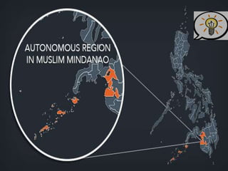
Autonomous Region of Muslim in Mindanao. One of the 17 regions of the Philippines.

Recomendados
Mais conteúdo relacionado
Mais procurados
Mais procurados (20)
Destaque
Destaque (20)
Semelhante a ARMM
Semelhante a ARMM (20)
Último
Último (20)
ARMM
- 1. 1
- 2. 2
- 3. The region, is located in the Mindanao island group of the Philippines, that is composed of five predominantly Muslim provinces, namely: Basilan (except Isabela City), Lanao del Sur, Maguindanao, Sulu and Tawi-Tawi. It is the only region that has its own government. The regional capital is at Cotabato City, although this city is outside of its jurisdiction. 3
- 4. 1380 - Muslims arrived in Tawi-tawi and natives converted to Islam. 1457 - Sultanate of Sulu was established then Maguindanao and Buayan followed. The people collectively call themselves “Bangsamoro” to identify themselves under the Islamic law and culture. They resisted the three colonizers and nevertheless wasn’t annexed into the Philippine government after the declaration of Independence. Most of it’s territories have been separate so they were able to develop their own identity. 4
- 5. 1970’s (Marcos Regime) when tensions escalated between government forces and the (MNLF) Moro National Liberation Front. This prompted the president to issue a proclamation that created Autonomous Region in Southern Mindanao. Aug 1, 1989 - Creation of Autonomous Region in Muslim Mindanao through RA 6734 aka Organic Act. The ARMM was officially inaugurated on November 6, 1990 in Cotabato City. 5
- 6. 6 September 2, 1996, the MNLF and the Philippine Government signed the final Peace Agreement which led to the election of MNLF chairman Nur Misuari as Regional Governor of ARMM.
- 7. 7 The Peace Agreement also paved the way for the creation of the Special Zone of Peace and Development (SZOPAD) and Southern Philippines Council for Peace and Development (SPCPD) which was established by virtue of Executive Order No. 371 on October 21, 1996 by President Fidel V. Ramos. Governor Misuari was named SPCPD Chairman. Meanwhile, the Moro Islamic Liberation Front (MILF), another Moro armed group, continued with their struggle. Armed clashes between the military and the MILF escalated to a full war by the year 2000 displacing some 400,000 persons.
- 8. 8 When Pres. Gloria Macapagal Arroyo assumed the Presidency on January 2001 after the ouster of President Joseph E. Estrada, she reversed the all-out war policy of the Estrada Administration and initiated peace talks which led to the signing of a ceasefire agreement on June 22, 2001. Regional Governor: Mujiv S. Hataman
- 9. Basilan Isabela City Lanao del Sur Marawi City Maguindanao Shariff Aguak Sulu Jolo Tawi-tawi Bongao/Panglima Sugala 9
- 10. 10 Governor: Jum Jainuddin-Akbar Vice Governor: Keemhar Jay Reynon Sakkalahul
- 11. 11 Is an island province of the Philippines within the Autonomous Region in Muslim Mindanao (ARMM). It is the largest and northernmost of the major islands of the Sulu Archipelago and is located just off the southern coast of Zamboanga Peninsula. It composed of 11 municipalities and 2 cities.
- 12. 12 Its capital, Isabela City, is grouped together with Basilan for geographical and statistical purposes, but is administered independently as part of the Zamboanga Peninsula Region. Basilan is home to three main ethnic groups, the indigenous Yakans, and the later- arriving Tausugs and Zamboangueño. The Yakans and Tausugs are predominantly Muslim, while the Zamboangueño are mainly Christian.
- 13. Basilan's derive its name from its iron ore deposits. Tausug warriors and slave-traders from Sulu came to Taguima to purchase high-quality of magnetic iron ores, which they used for swords, knives and other blades. Thus, basih- lan means "the iron (magnet) trail" or "the iron way". The lingua franca is Chavacano, a Spanish creole dialect. 13
- 14. 14 Finely crafted Moro blades made from Basilan "basih" (iron).
- 15. Zamboanga City is the main gateway to Basilan Island which lies 17 nautical miles (narrowest point of the Basilan Strait) due north. If you’re from Manila or Cebu, take a flight to Zamboanga City then take a Jeepney bound for Canelar and walk towards the port. From there, a boat ride of 1 hour and 45 mins (for conventional passenger ferries), or 1 hour (for a fast craft), will take you to Isabela and Lamitan. 15
- 16. 16
- 17. 17 Peninsula point called Punta matangal in Tuburan that offers a haven for surfers very similar to that of the north shore of Hawaii. Rising from the waters at the shorelines are communities that seem to float which are called Samal houses on stilts lined on both sides by mangroves. Malamawi Island, the gateway to Basilan, where can be found the Badjao, Samal-Luaans-Banguingui, and Muslim cemeteries. The island boasts of the only lake in the province with wild ducks and is home to the Panigayan fishing village, an ideal spearfishing destination.
- 18. 18 Samal houses
- 19. 19
- 20. 20 Do some water activities in the 14-meter-high waterfalls of the Kumalarang River. In the heart of Isabela is the Santa Isabel Cathedral with its modern architectural design. Beside the cathedral is a display center of native handicrafts like mats, bags, and other products made of buri. The most remarkable feature of Bulingan Falls are its walls. One would suspect that it was a work by a landscape artist utilizing columns of rocks beautifully arranged and piled on top of each other, creating a wall that resembles a pipe organ. You will be amazed to find out that the wall is a natural rock formation.
- 23. 23 Not far from Isabela proper is the Kaum Purnah Mosque and Muslim Village, which shows Muslim culture through at least three tribes. The 400-meter-high Calvario Peak and its Chapel of Peace are a delight to photographers. Sumagdang Beach is a natural swimming resort amidst coconut plantations, mini rice fields, and fishponds. The next town of Lamitan is the best place to see the Yakan, a peace-loving people known for colorful clothes hand woven with intricate geometric designs as well as for elaborate weddings and festivals.
- 25. 25 Be stunned by the huge number of rubber trees in the area and how they were beautifully lined up. The canopy of rubber trees are absolutely a feast in the eyes.
- 26. 26
- 27. 27 Place: Lamitan, Basilan Date: June 29 It is celebrated during the Feast of St. Peter (Fiesta San Pedro). The Festival is highlighted by the participation of the Yakans who attend the festivities in full regalia, selling wares and produce brought in from their farms in the interior.
- 28. 28 Place: Isabela City, Basilan Date: April 25 It is an annual commemoration of its Cityhood, is a week- long series of activities culminating in the annual Street Dancing parade
- 29. 29 Place: Isabela City, Basilan Date: July 8 Celebrated in honor of its Patroness Saint Elizabeth of Portugal (Span. Sta. Isabel de Portugal), the focal point of the Fiesta celebrations happen around the Sta. Isabel Cathedral. This is highlighted by a Procession and Novena Masses, the traditional Bella Isabela Beauty Pageant, marathon, regatta and other activities.
- 30. 30 Place: Basilan Province Date: May 9 An Islamic event celebrating the nocturnal journey and ascension of Muhammad. Place: Basilan Province Date: December 27 An Islamic celebration honoring the birthday of Muhammad.
- 31. 31 Governor: Mamintal Alonto Adiong Jr. Vice Governor: Arsad Marohombsar
- 32. 32 Lanao del Sur forms the western portion of Northern Mindanao. It is bounded on the north by Lanao del Norte, on the east by Bukidnon, on the west by Illana Bay, and on the south by Maguindanao and Cotabato. The landscape is dominated by rolling hills and valleys, placid lakes and rivers. The province is subdivided into 39 municipalities and 1 city, Marawi which the capital. Marawi City is now the only chartered city in the country with predominantly Muslim population. The Maranao dialect is the most commonly spoken. Also spoken are Tagalog and Visaya as well as English and Arabic.
- 33. 33 Lanao comes from the word ranao, meaning "lake“. Lanao centers on the basin of Lake Lanao; thus, it is the land of the Maranaos, the "people of the lake“. When the Spaniards first explored Lanao in 1689, they found a well-settled community named Dansalan at the lake's northern end. Dansalan became a municipality in 1907 and a city in 1940. During the Pre-Spanish time, there are 4 important Boundaries hold the power of appointing a new sultan namely: Bakayawan, Dalama, Madambaand and Sawer. In appointing a new sultan the permission of these four boundaries are needed to validate the new sultan appointed to his position.
- 34. 34 By Air-Land: From Manila, take a flight bound for Cotabato City. Another option is to take a flight bound for Lanao del Norte. From there, several taxis travels to Marawi City. By Sea: Manila to Cagayan de Oro City travel by sea takes about an entire day. Once at the port, there are available public vehicles bound for Marawi City.
- 35. 35
- 36. 36 Aga Khan Museum Location: Mindanao State University, Marawi City, Lanao del Sur Named in honor of King Aga Khan who contributed to the realization of the museum. Historical development is banked on the large space where cultural materials where conserved. It has a huge, collection of indigenous art and recorded ethnic music tapes. It also highlights the native folk dances from different regions of Mindanao, Sulu and Palawan. The native tools and weapons used by the Muslims and different artistic designs of houses are the main attractions of museum.
- 37. 37 Cultural Town of Tugaya Location: Tugaya, Lanao del Sur It has a near-exclusive reputation for producing brassware, being the only community in the province that produces excellent brassware. Practically every family has a bellows in the area where the metals are smelted. Using the cire perdule or lost wax technique, cannons and gongs, betelnut boxes and rice pots are made.
- 38. 38 Torogans & Sambitory Old Building Location: Marawi City, Lanao del Sur The unique natural setting of the Maranaos in the city is best manifested by the presence of the many large torogans, the Maranao houses, characterized by an antique royal high roof with curved designs.
- 39. 39 Moncado Colony Location: Marawi City, Lanao del Sur It was named in honor of Dr. Hilario Camino Del Prado Moncado, who is best known as the founder and Supreme Commander-in-Chief of the Filipino Crusaders World Army. He is a leader, an organizer, author of books and lecturer of humanities, a delegate to the 1935 Constitutional Convention and a candidate for President of the Philippines in 1941.
- 40. 40 Mindanao State University Location: Marawi City, Lanao del Sur Mindanao State University was established on September 1, 1961. Formal classes opened in June 1962. It has six autonomous campuses throughout Mindanao. Kilometer Zero Point Marker Location: Marawi City, Lanao del Sur It is an important landmark in Lanao del Sur, from which all distances in Mindanao are measured. This is similar to the measures of distances in Manila which begin at the Rizal Monument in Rizal Park
- 41. 41 Lake Lanao Location: Lanao del Sur It is the largest lake in Mindanao, and the second largest lake in the Philippines and counted as one of the 15 ancient lakes in the world. It is also the deepest in the Philippines, at 2,300 feet above sea level. The lake is home to 18 endemic species of freshwater fish and supports a large number of waterfowl.
- 42. 42 Agus River Location: Marawi City - Linamon, Lanao del Sur It is considered as the swiftest river in the country. Its famous cataract is the Maria Cristina Falls, outlet of Lake Lanao to Illana Bay. In Maranao mythology, Lake Lanao once threatened to drown the people of Sebangan with its ever-rising waters. The Archangel Gabriel is thought to have made the Agus river in order to drain the lake. Bagang Beach Location: Caloocan, Marawi City, Lanao del Sur The beach is filled with rocks and boulders that serve as benches, and trees in the lakeside that provide shade. It is ideal for picnics, and its clear water makes it a good place for boating and swimming.
- 43. 43 Mt. Mupo (Sacred Mountain) Location: Brgy. Papandayan and Guimba, Marawi City, Lanao del Sur It is proclaimed as one of the national park and protected area. The forest area covers around 372.986 hectares. A variety of high value timber trees such as narra, lawaan and tangile. It is known for its untouched trees, beautifuland perfect cone. Mt. Siningcaongan or Signal Hill Location: Marawi City, Lanao del Sur It is occupiedas the home of the military camp of the battalion command of the Philippine Army. This small mountain is facing the Provincial Capitol of Lanao del Sur and the panoramic view of Lake Lanao .
- 44. 44
- 45. 45 Place: Bacolod-Kalawi, Lanao del Sur, Date: Two and a half months after the Eid’l Fitr it is in commemoration of the Islam Revolution. It signifies the progressive realization of Islamic principles and teachings among believers.
- 46. 46 Location: Wao, Lanao Del Sur Date: February 22 Kalilang and Kariyala both mean “merrymaking and thanksgiving”. This universal expression of thanksgiving for the triumphs, abundance, prosperity or any form of blessings received. The celebration of this is festival are similar to Lami- Lamihan of Lamitan, Basilan and Meguyaya of Upi, Maguindanao.
- 47. 47 Location: Marawi City Date: April 15 A festival commemorating the charter anniversary celebration of Marawi City Highlights of the festival are Qur’an Reading Contest, presentation of colorful Muslim songs and dances, Islamic Quiz Bee, exhibits of Maranao crafts, native delicacies, traditional games and musical instruments competition.
- 48. 48 Governor: Esmael Mangudadatu Vice Governor: Lester Sinsuat
- 49. 49 Maguindanao is a province of the Philippines located in the Autonomous Region in Muslim Mindanao (ARMM). Its capital is Shariff Aguak. It borders Lanao del Sur to the north, Cotabato to the east, and Sultan Kudarat to the south. Maguindanao means “people of the flood plain”. The Maguindanao are most heavily concentrated along the shores and in the flood lands of the Pulangi-Mindanao River basin.
- 50. 50 Maguindanao is composed of 36 municipalities, which are further subdivided into 506 barangays. Cotabato City is often grouped with Maguindanao, but it is actually independent from the province. The province is divided into two congressional districts. In October 2006, the first congressional district was split off into a new province, Shariff Kabunsuan. However, the ARMM's Act creating the province was nullified by the Supreme Court in July 2008, on the basis that creation of a province is a function of the Philippine legislature. The area has since reverted to the province of Maguindanao.
- 51. 51 By Air: There are direct flights from Manila, Cebu, and Zamboanga City that are bound for Cotabato City. Travel time ranges from 1 hour and 30 minutes (from Manila) to 25 minutes (from Zamboanga) By Sea: Commercial ferries travel from Manila, Cebu, and Zamboanga City towards Cotabato City once a week, docking at Polloc Wharf. Travel time is two days from Manila.
- 52. 52
- 53. 53 Takumi Butai Memorial Shrine Location: San Sebastian Compound, Cotabato City The monument is in honor of Takumi Butai and the Japanese soldiers who died here during the second World War. Takumi was the Provincial Commander of the Japanese forces assigned in Cotabato City. Before he died, he requested that some of his ashes be buried in Cotabato City.
- 54. 54 Kutawato Caves Location: Tantawan Hill, Cotabato City It got its name from the words “kuta” means fort and “wato” means stone hence the name fort of stone. Kutawato caves with its walls of white, beige and brownish shade, glitters in the dark and echoes a colorful past dating back to the days when no foreign foot yet trampled upon this island. These caves had given sanctuary to the natives when the Spaniards tried to convert them into the faith. It also served as garrison and armory for Filipino guerillas who fought the invading force of the Japanese Imperial Army during the Second World War.
- 55. 55 Autonomous Region for Muslim Mindanao Compound Location: Gov. Gutierrez Avenue, Cotabato City Considered as the symbol of the Bangsamoro’s struggle for self-determination, the ARMM conducts governance in a 4- hectare compound housing the Office of the Regional Governor, Regional Legislative Assembly, Shariff Kabunsuan Cultural Center, Regional Museum and Regional Offices, including those of Region XII of which Cotabato City is a part of. The buildings in the compound showcase unique blend of modern and Muslim architecture.
- 56. 56 Cotabato City Hall Location: Cotabato City It is a century-old structure that houses almost all the city government offices. It showcases a unique antique architectural design depicting Muslim art. Caverna Espanola Location: Cotabato City Twenty one flights of stairs and three unconnected winding tunnels lead to cave bowels bearing a colonial-era Spanish Dungeon turned World War II Japanese jail.
- 57. 57 Be astonished with the sacred spaces and beautiful interiors of the Blue Mosque (Masjid), a place of worship for the followers of Islam that will surely leave one in awe for its marvelous architecture. Accentuated by its color, the Mosque is a famous attraction and landmark in Parang that lies along Narciso Highway. If yearning for a great expedition, try mountaineering to enjoy the wonderful vista on top of Mount Biarong that overlooks the panoramic view of Upi municipality, known as “the Little Baguio” of the Province. Blue Mosque
- 58. 58 P.C. Hill / Tantawan Hill Location: Cotabato City This is a stone fort towering over the city with a height of 90 feet. It houses the Cotabato City Internal Defense Command. This historic hill served as a watch tower for the natives. It commands a panoramic view of the city and Rio Grande de Mindanao. Kweba ni Satur Location: Tantawan Hill, Cotabato City It is a former snake pit once thought to be the mouth of hell. One has to descends via vine or rope or marches down a flight of stairs to go inside the feared cave.
- 59. 59 Rio Grande de Mindanao Location: Cotabato City It is the second largest river in the Philippines and the longest in Mindanao, crisscrossing with its tributaries the city's vast area. It is estimated to be 182 kilometers long and 96 meters wide. Water sports and boat racing are the popular attractions of the river, usually held to coincide with the Shariff Kabunsuan Festival and the Feast of Hariraya Puasa.
- 60. 60 Timako Hill Location: Cotabato City The hill overlooks the Illana Bay. It is graced by the beach resorts of Linik, Kushiong, and Tapian Point, characterized by blue waters and a sandy white beach. Timako is an ideal site for camping, boating, swimming, and fishing. Bagua Cave Location: San Vicente St., Cotabato City The caverns filled with rock and mineral formations has been transformed into stages for theatrical and musical performances. Spring water flows into various pools that augment the ambiance during art and photo exhibits, while the many hidden chambers support myths of treasures hidden by the Japanese during World War II.
- 61. 61 Our Lady of Lourdes Grotto Location: Brgy. Awang, Cotabato City It is a replica of France's Our Lady of Lourdes Grotto. The site has attracted many visitors, mostly devotees, believing that the statue has been a source of miracles. The compoundboasts an ideal retreat house for recollections and seminars, a mini zoo, and a children's park. Tamontaka Church Location: Brgy. Tamontaka, Cotabato City It was built in 1872 following Spanish architecture and design. The oldest church in the city, it is a relic of the living past.
- 62. 62
- 63. 63 Place: Cotabato City Date: December 19 It is a colorful festival commemorating the arrival of Sharif Muhammed Kabungsuwan via Rio Grande de Mindanao more than 500 years ago to introduce Islam to the natives. The festival is highlighted by a fluvial parade along Rio Grande de Mindanao followed by the re-enactment of his arrival. Water sports, boat racing, ethnic sports competition, cultural dances, and a week-long trade fair, add color to the festival.
- 64. 64 Location: Upi, Maguindanao Date: December 19 The term is a Teduray word meaning ‘Merrymaking and Thanksgiving” This is a universal expression of thanksgiving for the triumphs, abundance, prosperity or any form of blessing received.
- 65. 65 Date: Every 2nd week of February Sagayan is a Philippine war dance performed by both the Maguindanao and Maranao depicting in dramatic fashion the steps their hero, Prince Bantugan, took upon wearing his armaments, the war he fought in and his subsequent victory afterwards.
- 66. 66 Place: Cotabato City Date: June 20 It commemorates the creation of Cotabato as a charter city. The celebration is marked by cultural presentations, trade exhibits, athletic competitions, and other events such as the drum and bugle corps competition and "saranggolahan" (Kite Festival). The highlight of the affair is the "Mutya ng Kotabato" pageant on the eve of the foundation day.
- 67. 67 Governor: Abdusakur Tan II Vice Governor: Abdusakur Tan
- 68. 68 Far-flung Sulu is the southernmost part of the Philippines, lying between the Sulu Sea on the north and the Celebes Sea on the south. Although far, many tourist travel here to see and experience the beauty of island province.
- 69. 69 It composed of 19 municipalities and 410 barangays. Although consisting of a mixed community of Muslims, the Tausug dominate the Sulu Archipelago. The Tausug were among the first inhabitants of the Philippines to embrace Islam as a religion and a way of life. They are referred to as ‘people of the current’, reflective of their close ties to the sea.
- 70. 70 By Air: Take a flight to Zamboanga City. From there, take a chartered flight bound for Jolo, Sulu. Plane lands at Jolo Airport. By Sea: Commercial ferry boats travel to Zamboanga City. Travel time from Manila to Zamboanga City is 29 hours, estimated. Ferry boats at Zamboanga Port travel towards Sulu.
- 71. 71
- 72. 72 American Calvary Monument Location: Jolo, Sulu Known as the Sunken Garden, this was built to thank the American soldiers who fought for the people from Jolo. Sulu Ethnological Museum Location: Notre Dame of Jolo College, Jolo, Sulu It is a private museum that has displays relating to the local culture and to Jolo's early trade with Indonesia China and the Arab world. Visitors can watch mat-weaving and purchase fine handicrafts such as cloth, mats, and bags at NACIDA shop at Notre Dame College.
- 73. 73 Walled City / Walls of Intramuros Location: Jolo, Sulu The wall measures at 8 ft. high 1-1/2 ft. thick and surrounds the former Spanish garrison of Jolo. It served as a protection against intermittent attacks by Moro sabil-illah (Juramentados). It was constructed by the Spanish occupation army soon after the fall of Jolo on February 29,1878, with labor supplied by Filipino deportados who were prisoners of the Spanish Army.
- 74. 74 Plaza Tulay Monument Location: Brgy. Tulay, Jolo, Sulu This monument was erected by Spanish Gov. Jose Arolas in 1891 to commemorate three occasions when Jolo was occupied by Spanish forces. One side of the monument bears the inscription “A la gloria de los que con su esfuerzo hicieron esta tierra Espanola “; the second side bears the inscription” Corcuera,17 de Abril de 1638”; the third side , “Urbiztondo, 28 de Febrero de 1851”; the fourth side, “Malcampo, 29 de Febrero de 1876”.
- 75. 75 Poon Tao Kong Marker Location: Jatin Tunggal, Indanan, Sulu The marker remembers the contribution of Psi Hsien who served as leader ambassador of goodwill of China. He died in 1408 and was given the name Poon Tao Kong, the Celestial. He was a Muslim Chinese Emperor to send Moslem emissaries or tribute collectors to Moslem countries.
- 76. 76 Fort of the Princess of Asturias Location: Jolo, Sulu Built by the Spaniards, this building was dedicated to the Princess of Spain. When Spanish forces left Jolo in 1899, the Americans made this military headquarters of the Philippines scout then later the Constabulary up to 1942. When Japanese Imperial Forces occupied Jolo the basement of this building served as the dungeon where Filipinos were tortured in 1945. Sulu Provincial Capitol Location: Jolo, Sulul It was constructed during the administration of Governor Murphy Sangkula. Its Moorish-inspired architectural design makes it a must-see site. CAPITOL
- 77. 77 Tubbataha Reef Location: Sulu Sea It draws divers from all over the world with its underwater splendor and the rich marine life that abounds in the reef. Snappers, sweet lips, groupers, angel fish, and morays can be found, amid huge fan corals and sponges. Large schools of barracudas, jacks, rainbow runners, and surgeons pass by while tunas race about.
- 78. 78 Pearl Farm at Marungas Island Location: Marungas Island, Jolo, Sulu The island, located in Sulu Sea, is dotted with coral reefs and can provide probably some of the world's best dive spots for those seeking the ultimate in underwater beauty and adventure. Dubbed as the “Mother of Pearls”, Sulu pearls were considered as the finest in the world, found in high-bred shells in deep, clear, and rapid tidal waters.
- 79. 79 Maubo Beach Location: Patikul, Sulu It boasts of about one kilometer of white sand, and is most frequented by the residents due to its accessibility. Tanjung Beach Location: Indanan, Sulu It is a white sand beach situated just three kilometers away from the town proper.
- 80. 80
- 81. 81 Place: Jolo, Sulu Date: 2nd Week of August A three-day cultural show and festivites commemorating the arrival of Rajah Baguinda who was responsible for the spread of Islam and reinforcing the Sultanate Government in the Sulu Archipelago.THE FESTIVAL The shrine
- 82. 82 Governor: Nurbert Sahali Vice Governor: Tati Ahaja
- 83. 83 It is the southernmost province of the country, sharing sea borders with the Malaysian state of Sabah and the Indonesian North Kalimantan province, both on the island of Borneo to the west. To the northeast lies the province of Sulu. It is a cluster of 106 islands and islets scattered over Sulu and Celebes sea. It consist of 11 municipalities and 203 barangays.
- 84. 84 The name of Tawi-Tawi is a projection of the Malay word "jauh" meaning "far“. Prehistoric travelers from the Asian mainland would repeat the word as "jaui- jaui" to mean "far away" because of the distance of the islands from the mainland. The word "Tawi-Tawi" was picked up to later become the official name of the province. The people make their living mostly from the sea. Many of them live in house-boats, and more live in houses built over the water and connected by little bridges.
- 85. 85 By Air: Take a flight to Zamboanga City. From there, take a chartered flight bound for Tawi-Tawi. Plane lands at Sanga-Sanga Airport. Currently, only one airline company flies to Tawi-Tawi. By Sea: Commercial ferry boats travel to Zamboanga City. Travel time from Manila to Zamboanga City is 29 hours, estimated. Ferry boats at Zamboanga Port travel towards Bongao Commercial Port.
- 86. 86
- 87. 87 Badjao Vilage Location: Bongao, Tawi-Tawi One can visit the Badjao Village to see their lifestyle and the intricate art of weaving, which the Badjaos are known for. Sitangkai Location: Bongao, Tawi-Tawi Eye-catching Sitangkai is considered the "Venice of Tawi- Tawi" for its houses built on stilts above water. It is also the site for one of the few floating markets left in Asia, although it remains one of the liveliest. SITANGKAI
- 88. 88 Makhdum Memorial Location: Sibutu, Tawi-Tawi Legend has it that Arab Missionary Sheik Makdum,who constructed the Mosque in Tubig Indangan,was a powerful imam who could lift 3-foot diameter pillars. His remains are allegedly buried in two separate islands one of which is Simmunul the other,Tandubanak on the southern shore of Sibutu.
- 89. 89 Gusong Reef Location: Mapun (Cagayan de Tawi-Tawi), Tawi-Tawi Seagulls, known to the natives as "tallah-tallah," have settled here by the thousands to lay their eggs. Gusong Reef is a top producer of the delicious turtle eggs, ranking second only to the Turtle Islands. Bongao Peak Location: Bongao, Tawi-Tawi Dominating with a prominent vertical cliff on its north side,Bongao peak towers above the island,welcoming tourists. The peak is a protected monkey sanctuary in the capital town of Bongao. A natural watchtower provides a view of the expanse of sea and the string of islands of Tawi-tawi
- 90. 90 Manuk-Mangkaw Island / Musa Location: Bongao, Tawi-Tawi It is an island located slightly beyond and across the channel. It is said to be "floating like an umbrella“, under which submarines of the Allied Forces sought refuge from enemy depth charges during World War II. Manuk-Mangkaw derives its name from a cluster of branches atop an ancient tall tree forming the image of a hen about to walk. It was used as a landmark by seafarers who jestingly called upon the "hen" to take the first inevitable step - " manok mankaw," meaning "walk, then walk."
- 91. 91 Tahing-Tahing Beach Location: Tabawan, South Ubian, Tawi-Tawi With its crystal clear waters, it forms a natural swimming pool. A picnic haven, it is where a group of American soldiers were inspired to compose the song, "Tawi- Tawi Beach." Turtle Islands Location: Turtle Island, Tawi-Tawi The Turtle Islands,together with three islands of neighboring country Malaysia, and the surrounding coral waters, are the only living area of the Green Sea Turtles in Asia and in the whole world.
- 92. 92 Tubig Indangan Location: Simunul, Tawi-Tawi On this location stands the first Muslim mosque built by the Arabian missionary Sheik Makdum in 1380 A.D. It is a pilgrimage site for Filipino Muslims. Tandubanak Mosque Location: Sibutu, Tawi-Tawi It is the biggest mosque in Sibutu is the one in Tandubanak. Sporting a pink and green motif,it stands proudly along the narrow and singular road that bisects the island.
- 93. 93
- 94. 94 Place: Tawi-Tawi Province Date: September 24 - 27 The festival commemorates the foundation anniversary of the province. Highlight of the event include cultural presentation that showcases the colorful ethnic cultures of the Sama, Badjaos, Jama Mapuns and Tausugs, fluvial parades marine sports like the Paglomba-lomba ma Tahik Tawi-Tawi, a boat racing competition, and beauty pageant.
- 95. 95 Location: Bongao, Tawi-Tawi Date: September 25 This Festival is also called Agal- agal Festival (local name for carrageen seaweed), Thanks giving festivity for its good harvest (similar to Meguyaya). This week-long festivity is celebrated every forth week of September showcasing the region’s economic potentials, culture, costums and tradition
- 96. 96 Location: Simunul, Tawi-Tawi Date: November 07 Sheik Karimul Makhdum Festival is celebrated in commemoration for his good deeds for bringing Islam to the land. Sheik Karimul Makhdum is a 13th century Muslim missionary from Malaysia who established the first mosque in the Philippines; the mosque is located in Tubig Indangan, Simunul, Tawi-Tawi.
- 97. 97
- 98. 98 The ARMM Region is famous in rice delicacies, namely; duldul, pastil, katilapan, and pawa. Native dishes like chicken with currypowder. In addition of the muslim delicacies are putrid, sinigang na baka and tinadtag.
- 99. 99
Notas do Editor
- It is the only predominantly Muslim province that is governed primarily by its indigenous population, and whose most commonly spoken language is Zamboangueño Chavacano.
- If you wish to experience a different delight while traveling.. A sea voyage is also highly recommended.