Apidays New York 2024 - Accelerating FinTech Innovation by Vasa Krishnan, Fin...
MULTISCALE MODELLING OF URBAN CLIMATE
1. Eleventh International IBPSA Conference
Glasgow, Scotland
July 27-30, 2009
MULTISCALE MODELLING OF URBAN CLIMATE
Adil Rasheed1 and Darren Robinson1
1
Solar Energy and Building Physics Laboratory,
Ecole Polytechnique Fédérale de Lausanne,
Station 18, CH-1015 Lausanne, Switzerland.
represented by an urban canopy model. Such a model
ABSTRACT would improve the accuracy of energy predictions
Climate Modelling is a complex task. One of the from both building and urban resource flow
most important reasons is the presence of a large simulation software.
variety of spatio-temporal scales. There are climatic
changes that take place over a time period of a few
months and then there are gusts which might last
only a few seconds. Similarly there can be a strong
influence on the weather of a city due to the presence
of a large water body like a sea or of a mountain
having a dimension of a few tens or hundreds of
kilometres and then there can be a local influence due
to the presence of urban structures like buildings and
canopies having dimensions of the order of a few
meters only. It is not computationally tractable to
handle all of these scales in a single climate model.
However, we can solve this issue by an integration of
a global, meso and micro scale model capable of
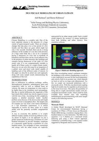
handling each of the different scales of interest. In Figure 1 Multiscale Modelling approach
this paper we describe in detail one such approach, But when investigating natural ventilation strategies
along with some sample results demonstrating the for buildings or the comfort of pedestrians in a city, it
capabilities of this tool. is also important to account for the local temperature
INTRODUCTION and velocity field in an accurate way; which depends
on local as well as on large scale phenomenon. For
Due to differences in radiation exchange, surface this we couple our mesoscale predictions with a
thermophysical properties, anthropogenic gains and microscale solver. With this one-directional coupling
evaporative sinks as well as reduced mean air high level models may be regarded as pre-processors
velocity, the mean air temperature in cities tends to to the lower level ones. This opens the possibility of
be higher than in the immediate rural surroundings. being able to couple microclimate models with pre-
But due to inertial differences the magnitude of this computed mesoclimate results, which could be made
heat island effect (which may also be negative) varies available from internet sites. Our modelling
with the time of day. Accounting for this complexity methodologies are presented along with some sample
requires a detailed numerical model. Another results in the following sections.
problem arises because of the diverse time and length
scales involved in atmospheric flow. The length scale MODELS
for example can vary from a few meters (buildings)
Mesoscale Model
to a few kilometers (mountains). It is almost
impossible to resolve all these scales in a single A Global Model developed by NCEP (National
model with the presently available computational Center for Environmental Prediction) having a
power. resolution of 270km x 270 km forces our Mesoscale
Model (MM) having a resolution ranging from a few
A way to overcome this problem is to couple
hundred meters to a few kilometres. The MM solves
different models capable of resolving different scales.
equations 1 to 6 (below) on a structured terrain
As shown in Figure 1 in our approach we use a
following grid using a finite volume approach.
global numerical model having a resolution of a few
Turbulence is modelled using a one equation model
hundred kilometers to provide boundary conditions
suggested by Bougeault and Lacarrere (1989)
to a mesoscale model having a resolution of a few
hundred meters. The exchanges of mass, momentum
and energy with the urban texture are implicitly
- 505 -
2. Governing Equations ∂A
W ′A′ = − K z …(5)
Mass Conservation equation: This simply states that, ∂z
in any arbitrarily chosen control volume in the K z = C k lk E 3 / 2 …(6)
atmosphere, the mass of air is always conserved.
Furthermore since the wind speed encountered in the
The radiation (both longwave and short wave) model
atmosphere is never comparable to the speed of
of Schayes (1982) is used along with the possibility
sound we can further make an assumption that the
to switch to the Simplified Radiosity Algorithm
fluid is incompressible. Putting this mathematically
described later in this paper.
we have that:
∂ρU i Urban Canopy Model
=0 ...(1)
∂xi In the previous section we described our mesoscale
Momentum Conservation Equation model which typically has a resolution of a few
This simply states that, for any arbitrarily chosen hundred metres. In order to resolve the scales smaller
control volume in the atmosphere, the rate of change than this grid a one-dimensional Urban Canopy
of momentum of the packet of air is equal to the Model (UCM) has been developed. The governing
resultant of the total force acting on that volume. equations (7,8,9) of the UCM for predicting the
Mathematically, this can be represented as follows: velocity, temperature and turbulent kinetic energy
… (2) profiles inside the canopy is obtained by a spatial
∂ρU ∂p ∂U U ∂U ′W ′ θ −θ
=− − − −ρ gδ i 3 − 2ε ijk Ω j (U − U kG ) + Dui
i j
∂t
i
∂xi ∂x j
i
∂z θ0
0
averaging of the equations which form the basis of
the mesoscale model. This averaging assumes
In Equation 2, the term on the left hand side is the
periodicity in the occurrence of urban structures. A
rate of change of momentum. The first term on the
building is represented by a block of specified width,
right hand side is the gradient of pressure. The
breadth and height while the street is represented by
second is the advection term, the third term arises
its width and orientation (Figure 2).
due to turbulence, the fourth term is the result of
buoyancy and the fifth term is the corialis force that
results from the rotation of the earth, while the last
term is the source or sink of momentum. This can be
used to account for the drag or shear forces due to
buildings encountered in a city.
Energy Conservation Equation
The energy conservation principle states that for a
particular control volume the imbalance in energy
input and output leads to a change in the internal
energy of the air in that volume.
R /C
∂ρθ ∂ρθ U i ∂ρθ ′W ′ 1 ⎡ p0 ⎤ ∂Rl
p
…(3) Figure 2: Geometries handled in the UCM
=− − −− +D
Cp ⎢ p ⎥
θ
∂t ∂xi ∂z ⎣ ⎦ ∂z
The drag forces offered by the rectangular cuboids
In Equation 3, the LHS is the rate of change of the have been taken to be proportional to the square of
internal energy of the air packet. The first two terms the local velocity field and the turbulent and
on the RHS are the advection and the turbulent dispersive fluxes (which arise due to the spatial
transportation of potential temperature respectively averaging) have been combined (because they are
The third term on the RHS represents the radiative similar for B/W > 1). At the lower boundary both the
heating of the packet of air, while the last term horizontal velocity components are taken as zero.
represents the source or sink of the energy equation. The upper boundary condition is applied at 3.4 times
the height of the cube. Constant values are applied at
Turbulent Kinetic Energy Equation the upper end by the MM. For the energy equation a
∂ρ E ∂U E ∂ E′W ′ ⎡⎛ ∂U ⎞2 ⎛ ∂U y ⎞2 ⎤ g ∂θ E3/ 2
=− i − + ρ K z ⎢⎜ x ⎟ + ⎜ ⎟ ⎥ − ρ Kz − ρCε + DE constant heat flux is given at the ground surface and
∂t ∂xi ∂z ⎢⎝ ∂z ⎠ ⎝ ∂z ⎠ ⎥ θ0
⎣ ⎦
∂z lε
…(4) at the top boundary the temperature is supplied by the
The LHS of the Equation 4 is the rate of change of MM.
turbulent kinetic energy. The first, second, third,
fourth, fifth and sixth terms on the RHS correspond
∂u 1 ∂ ⎛ ∂u ⎞
to the advection, turbulent transportation, shear = ⎜ K zu Λ ⎟ − a1Cd u u + v
2 2 … (7)
production, buoyancy production, dissipation and ∂t Λ ∂zc ⎝ ∂zc ⎠
additional sources of turbulent kinetic energy.
∂v 1 ∂ ⎛ ∂v ⎞
= ⎜ K zv Λ ⎟ − a2Cd v u + v
2 2 …(8)
The turbulence terms in all of the above equations are ∂t Λ ∂zc ⎝ ∂zc ⎠
modelled as Equation 5 and 6: ∂θ 1 ∂ ⎛ ∂θ ⎞
= ⎜ K zθ Λ ⎟ − Qθ …(9)
∂t Λ ∂zc ⎝ ∂zc ⎠
- 506 -
3. B1 Pb ( z ) vertical profiles of velocities and temperature which
a1 = ...(10)
are then used to compute the effects of drag forces,
( B1 + W1 )( B2 + W2 ) − B1 B2 Pb ( z )
shear forces and the convective exchange of energy
B2 Pb ( z )
a2 = ..(11) between the building and its surroundings. These are
( B1 + W1 )( B2 + W2 ) − B1 B2 Pb ( z ) called the sources of momentum and energy at the
Urban Canopy scale. They can be further modified
⎛ B1 B2 ⎞
Λ = 1− ⎜ ⎟ Pb ( z ) ...(12) using a Building Energy Model to include the effects
⎝ ( B1 + W1 )( B2 + W2 ) ⎠ of air-conditioning. These UCM sources are then
2 2
interpolated back to the Mesoscale grid thus
⎛ ∂u ⎞ ⎛ ∂v ⎞ Sm 2
3/
providing the sources of the respective equations at
K zu = K zv = K zθ = L2 ⎜ ⎟ +⎜ ⎟ the mesoscale.
⎝ ∂zc ⎠ ⎝ ∂zc ⎠ C
...(13) Microscale Model
A complete derivation of the expression of Kzu can be As stated earlier the mesoscale model gives the
found in Gambo (1978). The length scale L is given velocity and temperature profile at a resolution of a
by Watanabe and Kondo (1990) and was derived few hundred meters. However, one might be
from considerations of a forest canopy: interested in a more detailed profile of these
quantities to evaluate natural ventilation potential or
pedestrian comfort. To achieve this, a high-resolution
2κ 3
L ( zc ) = (1 − exp(−η ) ) ...(14) numerical computational model is used which
ca combines fluid dynamics calculations with the
caz ; thermodynamic processes taking place at the walls
η= ...(15)
2κ 2 and roof surfaces encountered in a city. To use a
purely conventional CFD approach to simulate air
and above the canopy we use an interpolation
flow around complex geometries encountered in a
formula after Blackadar (1968):
city one is normally left with no option but to use an
unstructured mesh (Figure 4(a)). But unstructured
κ zc ...(16) grid generation is a time consuming process and also
L ( zc ) ≤
κz the numerical methods for solving the conservation
1+
L0 equations with unstructured meshes suffer from
stability and convergence issues. In contrast a
which interpolates between two limits L ~ kz , at z Cartesian mesh (Figure 4(b)) is very easy to generate
= 0 and L = Lo as L → ∞ . In this study we have
and efficient numerical algorithms are available to
significantly reduce the computational time.
used a value of Lo = 70m. However, it is not straightforward to fit Cartesian
grids to complex geometries and doing so invariably
creates a great many redundant cells. As a
compromise we use a solution which combines
numerical stability with the possibility of creating
grids for complex geometries, called immersed
boundaries.
Figure 3: Modelling of the urban element (a) Unstructured Mesh
The source term appearing in the energy equation of
the UCM is the amount of energy exchanged with the
urban elements. To estimate this, a one dimensional
conduction equation is solved for walls, roofs and
ground (Figure 3) by assuming a fixed temperature
inside the building and 2m below the ground. At the
other surface (in contact with the air) a time
dependent heat flux (due to radiation) is applied as
the boundary condition. The UCM computes the (b) Structured mesh
Figure 4: Different types of mesh
- 507 -
4. In this approach the simulation around complex the sky contribution matrix. This matrix is then
geometries is conducted using a non body conformal simply multiplied by the radiance of each sky patch
cartesian grid in which the fluid solid interface is to obtain the incident energy at each surface.
represented by a surface grid, but the Cartesian Similarly, the sun view factors are used to obtain the
volume is generated with no regard to this surface direct contribution matrix. Finally, the view factors
grid. Thus the solid boundary would cut through the between surfaces are combined with the relative
Cartesian volume grid. Because the grid doesn’t angle between the surfaces to obtain the surface
conform to the solid boundary, incorporating the contribution matrix. This matrix allows for
boundary conditions requires us to modify the computation of the contribution due to reflection.
equations in the vicinity of the boundary. Assuming Further details including results from extensive
that such a modification is possible (of course it is) validation tests can be found in Robinson (2004)
the modified governing equations would then be
discretized using a finite difference, finite volume or MODEL CALIBRATION
a finite element technique without resorting to To demonstrate the capabilities of our Multiscale
coordinate transformation or complex discretization Model we have chosen the city of Basel. Basel is
operators. When compared with unstructured grid located at the border with Germany and France, at a
methods, the Cartesian grid-based IB method retains latitude and longitude of 47° 00' North and 8° 00'
the advantage of being amenable to powerful line- East, respectively.
iterative techniques and geometric multigrid
methods, which can also lead to lower per-grid-point To conduct a realistic simulation, input data such as
operation counts. the topography and land use are required.
Immersed Boundary Approach in an Urban Furthermore, to force the effects of the scales larger
Context: This new algorithm as against the than those handled by the mesoscale model
conventional CFD approach offers us the possibility appropriate meteorological data are required as
of simulating large domains. In principle constructing boundary conditions. Fortunately, these data are
urban geometry with a 3-D modeling tool is trivial available on the internet to be used by the scientific
and quick and such geometries can be readily community. However, before using them in the
converted into a STL (sterio lithography file) format simulations these data have to be processed. Below
which holds information about the solid-liquid we explain briefly how the various input data are
interface (in our case the building-atmosphere obtained and processed.
interface). The file is parsed to find out the solid and Meteorological Data
fluid zones. The flow equation is solved only in the
As noted earlier the scales that are comparable to the
fluid zone, so that in the solid zone the flow
grid size are resolved by the model. However, scales
equations are switched off. The air flowing over the
that are bigger than the domain or lie outside of the
buildings are treated as phase one and the buildings
domain can't be parameterized or resolved. Their
are treated as phase two. The Specific heat capacity,
effects are captured in the mesoscale model using a
conductivity and density of the two phases are
procedure called nesting (Figure 5(a) and 5(b)) via
specified for each building and the air separately. The
boundary conditions. The effects of oceans and
amount of solar radiation as well as the
mountains are taken into account by a Global model
anthropogenic heat generated due to human activities
like NCEP (National Center for Environmental
can be looked upon as heat sources which might vary
predictions). The data (velocity, humidity,
with time. The methodology to compute the solar
temperature, pressure) from this global model is
radiation is explained in the next section. The
available via a web portal cdc.no.gov (2008).
boundary conditions of velocity and temperature are
forced through the interpolation of results from Moreover, the global model has a resolution of
mesoscale simulations on to the microscale grid, with 270km X 270km whereas we require the velocities,
care being taken to impose mass conservation over temperature and humidity to be interpolated to a grid
the full domain. having a resolution of just 1m X 1km. For this we
first construct a domain with a resolution of 15 X 15
Simplified Radiosity Algorithm: In order to
km and assuming it to be 100% rural. We then run a
implement the SRA (Simplified Radiosity
simulation to generate an output file. This output file
Algorithm) for the calculation of longwave and
is then used to force another smaller domain with a
shortwave exchange in urban context, the view
higher resolution. We thus interpolate in a few steps
factors from each surface to a descretized sky vault,
from the global model to the mesoscale model
the sun to each surface and from surface to surface
domain.
are required. The view factors are computed by
rendering the scene from different points (sun Landuse
positions or the centroids of the triangles resulting
A major aim of this project is to study the interaction
from surface tessellization). The view factors of the
between the climate of a region and the urban
sky are used with the cosine of the angle of incidence
texture. It has been well established through various
between the surfaces and the sky patches to obtain
- 508 -
5. field experiments and numerical simulations that the
urban texture significantly affects the urban
microclimate. Relevant simulations of the urban
climate are therefore only possible when we input the
correct landuse data into the model. This data is
obtained from another web portal. The Global
Vegetation Monitoring Unit of the European
Commission Joint Research Centre, provides for the
year 2000 a harmonized land cover database over the
whole globe. From this data we can determine the
fraction of artificial surfaces. In Figure 6(a) one can
see the graphical representation of the data obtained
from the net and in Figure 6 (b) the processed result
in the format required by the mesoscale model. (b) Interpolated land usedata
Figure 6: Interpolation of land use data
Topography
A mesoscale domain may range from a few
kilometers to a few hundred of kilometers. Over such
a large expanse the topography may vary
significantly. Such variations can be taken into
account by downloaded topological data from the
website edc.usgs.gov (2008). This data is expressed
as a global digital elevation model (DEM) with a
horizontal grid spacing of 30 arcs seconds
(approximately 1km). In our case we have
(a) Raw downloaded data downloaded the topography of Europe. In Figure 7(a)
below one can see the graphical interpretation of the
raw data downloaded from the website. This data is
then processed (see Figure 7(a)) to extract the
topographical information for the domain we want to
simulate.
(b) Interpolated data
Figure 5: Interpolation of meteorological data
(a) Downloaded topography
(b) Interpolated topography
(a) Downloaded land use data Figure 7: Interpolation of topography
- 509 -
6. 3-D geometry simplified geometry match those of the actual city.
Here we describe a method, which not only
The final data requirement of our multiscale
eliminates the need of time-consuming field survey
modeling methodology relates to the geometry of
but also reduces a complex representation of a city to
buildings as input to microscale simulations. For this
an “equivalent” simplified representation. To
we produce an abstracted form of buildings’
accomplish this we choose a mesoscale cell and
geometry using the NURB (Non-Uniform Rational
download a Google image of its ariel view. The view
BSpline) based 3-D modelling software Rhinoceros.
is then used to create a three dimensional model. The
For this an aerial view of the city is obtained from
SRA is used to compute the distribution of radiation
Google Earth image (Figure 8(a)). The corresponding
on different types of surface (roofs, grounds and
2D geometry is sketched (Figure 8(b)) using
walls) while the IB technique is used to compute drag
Rhinoceros. The resultant polygons are then
and spatially averaged quantities (velocity and
vertically extruded according to the building heights
turbulent kinetic energy profiles) for the same
estimated from visual surveys.
domain. We then search for a simplified
representation (consisting of a regular array of cubes)
which has similar characteristics as the complex one.
Figure 9 presents an example to demonstrate the
concept.
(a) Complex
(a) Google image
(b) Sketched geometry using Rhino
Figure 8: 3-D geometry for microscale simulation (b) Simplified
Figure 9: Equivalent Simplified Geometry
Simplified geometry fitting
The inputs to the mesoscale model, which include
street width, building width, building density and a
statistical representation of the buildings’ heights, are
generally obtained through quantitative field surveys
(which are very slow and time consuming to
perform) or qualitative estimates. But in performing
this geometric abstraction there is no way to ensure
that the total built surfaces and volumes of the
- 510 -
7. In both the geometric representations of Figure 9 the Microscale Result
total built surfaces, built volume, the distribution of
In Figure 10 we present results relating to the district
shortwave radiation amongst different surfaces and
of Matthäus in Basel. For this the boundary
the average velocity profile are similar. Thus the
conditions have been forced on the microclimate
complex representation shown in Figure 9(a) can be
model using the results of the mesoscale model. The
replaced by the simplified representation shown in
ambient temperature tends to be higher in the regions
Figure 9(b) and can be used in a mesoscale
where the velocity is lower (Figure 11(b)); the more a
simulation.
packet of air circulates around a built structure the
RESULTS more time it has to exchange energy with the
buildings, thus becoming warmer. As can be
Mesoscale Results
observed in Figure 11(a) streams of air flowing
In Figure 10(a) we have assumed a hypothetical through the city attain a higher temperature compared
situation where the whole of Basel and its to the stream that avoids contact with built surfaces.
surrounding area is 100% rural, implying no urban
structures.
In Figure 10(b) we have presented the impact of
introducing a simplified urban representation of the
city; the result corresponding to midday at a height of
5meters above the ground. Here one can clearly see a
rise in temperature in and around the city. This can
be attributed to the increased absorption of radiation
by the urban structures, to the change in surface
thermophysical properties and a damping of air flow
in the city. The UHI intensity is around 5-6C which
can have a significant impact on energy demands for
cooling or heating.
(a) Streamlines and velocity vectors
(a) Rural (b) Temperature and velocity profiles along a line
stretching from one end of the domain to the other
along the direction of flow.
Figure 11: Microscale Simulation Results
CONCLUSIONS
In this paper we describe a new solution to handling
the range of time and length scales which influence
urban climate predictions in a computationally
tractable way. This involve the use of results from a
global meteorological model to force the boundary
conditions of a mesoscale model, in which a model
(b) Urban of the urban canopy is embedded. These mesoscale
Figure 10: Temperature profiles for rural and predictions may then be used to force the boundary
urban simulations for the city of Basel conditions of a local microscale model, so that good
quality local urban climate predictions may be
- 511 -
8. achieved whilst accounting for large scale climatic REFERENCES
tendencies such as the urban heat island effect.
Bougeault, P., Lacarrere, P., 1989, Parametrization of
This multiscale urban climate modelling method will Orography-Induced Turbulence in a Mesobeta-
be of use for building and urban scale performance Scale Model, Monthly Weather Review, 117,
predictions as well as for the future simulation of 1872-1890
pedestrian comfort. Schayes, G., 1982, Direct determination of
diffusivity profiles from synoptic reports,
Atmos. Environ., 16, 1407-1413.
ACKNOWLEDGEMENTS
Blackadar, A. (1968). The vertical distribution of
The financial support received for this work from
national research programme 54 of the Swiss wind and turbulent exchange in neutral
National Science Foundation is gratefully atmosphere. Jounal of Geophysics, 4:3085{3102
acknowledged. Gambo, K. (1978). Notes on the turbulence closure
model for atmospheric boundary layers. Journal
of the Meteorological Society of Japan,
NOMENCLATURE 56:466{480.
ρ Density of Air Kondo, H., Genchi, Y., Kikegawa, Y., Ohashi, Y.,
U i Velocities in three directions Yoshikado, H., and Komiyama, H. (2005).
p Pressure Development of a multi-layer urban canopy
model for the analysis of energy consumption in
U i′ Velocity fluctuations a big city: Structure of the urban canopy model
W ′ Velocity fluctuation in the vertical direction and its basic performance. Boundary-Layer
θ 0 Reference potential temperature Meteorology, 116:395{42
Watanabe, T. and Kondo, J. (1990). The in°uence of
θ Potential Temperature the canopy structure and density upon te mixing
θ ′ Fluctuation in potential temperature length within and above vegetation. Journal of
R Gas Constant Meteorological Society of Japan, 68:227{235}
C p Specific Heat Capacity of Air Robinson, D., Stone, A., Solar radiation modelling in
Rl Longwave radiation the urban context, Solar Energy, 77(3) 2004,
p295-309
Dui Source term for the momentum equation http://www.cdc.noaa.gov/cdc/reanalysis/reanalysis.sh
Dθ Source term for the energy equation tml
E Turbulent Kinetic Energy http://www-tem.jrc.it/glc2000
E ′ Fluctuation in turbulent kinetic energy http://edc.usgs.gov/products/elevation/gtopo30/gtopo
K z Turbulent diffusivity 30.htm
U x , U y Horizontal Mesoscale Velocites
g acceleration due to gravity
Cε , Ck Constants
lε Dissipative length scale
lk Length scale
DE Source term for the turbulent kinetic energy
u , v Horiontal velocities in the canopy
zc vertical distance in the canopy
K zu , K zv , K zθ diffusivity
Cd constant
B1 , B2 , W1 , W2
Pb ( z ) probability of having a building of height z
κ von karman constant
- 512 -