
Recomendados
Recomendados
Mais conteúdo relacionado
Mais procurados
Mais procurados (8)
Destaque
Destaque (10)
Semelhante a PhD_Thesis_GionaMatasci_2014_wCopyrights
Semelhante a PhD_Thesis_GionaMatasci_2014_wCopyrights (20)
PhD_Thesis_GionaMatasci_2014_wCopyrights
- 1. Unicentre CH-1015 Lausanne http://serval.unil.ch Year : 2014 Domain Adaptation in remote sensing: increasing the portability of land-cover classifiers Giona Matasci Matasci, Giona (2014) : Domain Adaptation in remote sensing: increasing the portability of land-cover classifiers Originally published at : Thesis, University of Lausanne Posted at the University of Lausanne Open Archive. http://serval.unil.ch Droits d’auteur L'Université de Lausanne attire expressément l'attention des utilisateurs sur le fait que tous les documents publiés dans l'Archive SERVAL sont protégés par le droit d'auteur, conformément à la loi fédérale sur le droit d'auteur et les droits voisins (LDA). A ce titre, il est indispensable d'obtenir le consentement préalable de l'auteur et/ou de l’éditeur avant toute utilisation d'une oeuvre ou d'une partie d'une oeuvre ne relevant pas d'une utilisation à des fins personnelles au sens de la LDA (art. 19, al. 1 lettre a). A défaut, tout contrevenant s'expose aux sanctions prévues par cette loi. Nous déclinons toute responsabilité en la matière. Copyright The University of Lausanne expressly draws the attention of users to the fact that all documents published in the SERVAL Archive are protected by copyright in accordance with federal law on copyright and similar rights (LDA). Accordingly it is indispensable to obtain prior consent from the author and/or publisher before any use of a work or part of a work for purposes other than personal use within the meaning of LDA (art. 19, para. 1 letter a). Failure to do so will expose offenders to the sanctions laid down by this law. We accept no liability in this respect.
- 3. Faculté des Géosciences et de l’Environnement Institut des Dynamiques de la Surface Terrestre DOMAIN ADAPTAT ION IN REMOTE SENSING: INCREASING THE PORTABI L I TY OF LAND-COVER CLASSI F IERS Thèse de doctorat présentée à la Faculté des Géosciences et de l’Environnement de l’Université de Lausanne par giona matasci B. Sc., M. Sc. Université de Lausanne, Suisse jury Président du colloque: Prof. Eric Verrecchia Directeur de Thèse: Prof. Mikhail Kanevski Co-directeur de Thèse: Dr. Devis Tuia Expert: Prof. Pascal Frossard Expert: Prof. Melba Crawford Expert: Prof. Paul Scheunders Lausanne, 2014
- 4. Giona Matasci: Domain Adaptation in remote sensing: increasing the porta-bility of land-cover classifiers, PhD Thesis submitted to the Faculty of Geo-sciences and Environment of the University of Lausanne in partial fulfillment of the requirements for the degree of Doctor in Environmental Sciences, © September 2014.
- 7. DOMA IN ADAPTAT ION IN R EMOT E S ENS ING: INC R E A S ING THE PORTABI L I T Y OF L AND- COV E R C L A S S I F I E R S Giona Matasci — Institute of Earth Surface Dynamics ABST R A C T Among the types of remote sensing acquisitions, optical images are certainly one of the most widely relied upon data sources for Earth observation. They provide detailed measurements of the electromagnetic radiation reflected or emitted by each pixel in the scene. Through a process termed supervised land-cover classification, this allows to automatically yet accurately distinguish objects at the surface of our planet. In this respect, when producing a land-cover map of the surveyed area, the availability of training examples representative of each thematic class is crucial for the success of the classification procedure. However, in real applications, due to several constraints on the sample collection process, labeled pixels are usually scarce. When analyzing an image for which those key samples are unavailable, a viable solution consists in resorting to the ground truth data of other previously acquired images. This option is attractive but several factors such as atmospheric, ground and acquisition conditions can cause radiometric differences between the images, hindering therefore the transfer of knowledge from one image to another. The goal of this Thesis is to supply remote sensing image analysts with suitable processing techniques to ensure a robust portability of the classification models across different images. The ultimate purpose is to map the land-cover classes over large spatial and temporal extents with minimal ground information. To overcome, or simply quantify, the observed shifts in the statistical distribution of the spectra of the materials, we study four approaches issued from the field of machine learning. First, we propose a strategy to intelligently sample the image of interest to collect the labels only in correspondence of the most useful pixels. This iterative routine is based on a constant evaluation of the pertinence to the new image of the initial training data actually belonging to a different image. Second, an approach to reduce the radiometric differences among the images by projecting the respective pixels in a common new data space is presented. We ana-lyze a kernel-based feature extraction framework suited for such problems, showing that, after this relative normalization, the cross-image generalization abilities of a classifier are highly increased. Third, we test a new data-driven measure of distance between probability distri-butions to assess the distortions caused by differences in the acquisition geometry affecting series of multi-angle images. Also, we gauge the portability of classi-fication models through the sequences. In both exercises, the efficacy of classic physically- and statistically-based normalization methods is discussed. Finally, we explore a new family of approaches based on sparse representations of the samples to reciprocally convert the data space of two images. The projection function bridging the images allows a synthesis of new pixels with more similar characteristics ultimately facilitating the land-cover mapping across images. v
- 8. DOMA IN ADAPTAT ION IN R EMOT E S ENS ING: INC R E A S ING THE PORTABI L I T Y OF L AND- COV E R C L A S S I F I E R S Giona Matasci — Institut des Dynamiques de la Surface Terrestre R É SUMÉ Parmi les types de mesures par télédétection, les images optiques sont certaine-ment l’une des sources de données les plus largement utilisées pour l’observation de la Terre. Elles fournissent des informations détaillées concernant le rayonnement électromagnétique réfléchi ou émis par chaque pixel de la zone étudiée. À travers un processus appelé classification supervisée, ces images permettent d’identifier de façon automatique et précise les objets à la surface de notre planète. À cet égard, lors de la production d’une carte de la couverture du sol, la disponibilité d’exemples d’entrainement représentatifs de chaque classe thématique est cruciale pour le succès de la procédure de classification. Cependant, dans des applications concrètes, en raison de plusieurs contraintes dans la collecte des échantillons, les pixels étiquetés sont généralement rares. Lors de l’analyse d’une image pour laquelle ces exemples clés ne sont pas disponibles, une solution viable consiste à recourir aux données de terrain ap-partenant à d’autres images précédemment acquises. Cette option est intéres-sante, mais plusieurs facteurs tels que les conditions atmosphériques, au sol et d’acquisition peuvent entraîner des différences radiométriques entre les images, empêchant partiellement le transfert des connaissances d’une image à l’autre. L’objectif de cette Thèse est de fournir aux analystes d’images de télédétection des techniques de traitement appropriées pour assurer la portabilité des modèles de classification entre les différentes images. Le but ultime est de cartographier l’occupation du sol sur de grandes étendues spatiales et temporelles à partir d’un minimum d’informations au sol. Pour corriger, ou tout simplement quantifier les changements observés dans la distribution statistique des spectres des matériaux, nous étudions quatre approches issues du champ d’études de l’apprentissage au-tomatique. Premièrement, nous proposons une stratégie pour échantillonner intelligemment l’image à classifier afin d’acquérir les étiquettes thématiques en correspondance que des pixels les plus utiles. Cette routine itérative est basée sur une évaluation constante de la pertinence pour la nouvelle image des données d’entrainement initiales appartenant à une image différente. Dans un deuxième temps, nous présentons une approche pour réduire les dif-férences radiométriques entre les images en projetant les pixels respectifs dans un nouvel espace de données commun. Des méthodes à noyaux pour la réduction de dimensionnalité adaptées pour de tels problèmes sont analysées. Il est montré qu’après cette normalisation relative, les capacités de généralisation entre images d’un classificateur sont fortement augmentées. Ensuite, nous testons une récente mesure non-paramétrique de distance entre distributions de probabilité pour évaluer les distorsions causées par des différences dans la géométrie d’acquisition affectant des séries d’images multi-angulaires. En outre, la portabilité des modèles de classification à travers les séquences est aussi mesurée. Dans ces deux exercices, nous discutons l’efficacité des méthodes clas-siques de normalisation à base statistique et physique. Enfin, nous explorons une nouvelle famille d’approches fondées sur les représen-tations parcimonieuses des échantillons afin de convertir réciproquement l’espace de données de deux images. La fonction de projection joignant les images per-met de synthétiser de nouveaux pixels avec des caractéristiques plus proches qui faciliteront finalement la cartographie de l’occupation du sol entre des images dif-férentes. vi
- 9. A CKNOWL EDGMENT S During these four years many people contributed to this work, some directly, others indirectly, but all of them pushed me a bit forward and made this achievement possible. Let’s start with my co-advisors, Prof. Mikhail Kanevski and Dr. Devis Tuia. Mikhail has always been a great supervisor, starting from my Master thesis back in 2008 all the way through this PhD. I am very grateful to him for having introduced me to the world of research in general, and specifically to the fields of machine learning and data analysis. The person that has played the biggest role in my leaning towards remote sensing is certainly Devis, as much a friend as an advisor. It all began with a semester project on the analysis of these “weird” images and who would have guessed this would ultimately lead to a PhD thesis! Devis, the list of things you taught me during these years is endless and I cannot find a proper way to thank you for all this. Lots of advice for some parts of the thesis was provided by Prof. Lorenzo Bruzzone. I wish to thank him and his RSLab for hosting me for that in-ternship and for the nice time I had in Trento (and on the surrounding ski slopes). I am equally indebted to Fabio and Nathan at DigitalGlobe for the great collaboration we had/are having, mostly via remote video conferences, al-though we also had time to meet and have fun together at real conferences all around the world. I owe a lot to Frank, a fellow PhD student at EPFL. He (and Diego, who I thank as well) showed great patience in teaching me the secrets of dictionaries and sparse representations. Also at EPFL, I am grateful to the guys of LaSIG for the frequent scientific (read “cross-lab presentations”) and less scientific (read “Sat”) exchanges. I would like to acknowledge all the members of the Jury who agreed to read and evaluate this Manuscript, in particular Prof. Paul Scheunders who came to Lausanne twice to listen to me. Furthermore, I express my gratitude to Prof. François Bavaud for intro-ducing me to statistics and to Prof. Gustavo “Gustao” Camps-Valls for the many things I learned from him about remote sensing. At UNIL, the colleague that deserves a special thank you is Mitch, the (lucky?) friend who had to share the office (actually three of them in two different buildings) with me for almost the entire length of the thesis. Your humor inside and outside the office will never be forgotten! Enjoyable moments have been the norm within the GIGAR group and therefore I would like to deeply thank its past and present members, espe-cially Loris and Mary. A big “merci” goes to the wider IGAR family for the countless apéros, lunches, dinners, ski runs and hockey matches we did together during these vii
- 10. years. Moreover, I cannot overlook the technical and administrative help provided by Simon, Carole and Sabrina. Thank you! After moving to Géopolis, I appreciated the great atmosphere we have been able to build with the other members of IDyST and the corridor-mates, in particular with those endless baby-foot matches at Zélig. Of course, a thesis cannot be accomplished without friends from outside the university. Thus, I would like to say thank you to all my friends from Ticino and in Lausanne that helped me free my mind in my spare time. A special place in this long list is reserved for my parents, Franca and Sandro, and for my brother Nico. The constant support and encouragement I received from you during my years in Lausanne is invaluable. Also, I want to warmly thank all the relatives, particularly those in Gordemo. Grazie davvero a tutti! Finally, the person to whom I owe the most is Livia. No combination of words can express my feelings for you. I thank you from the bottom of my heart for always having been there for me when I needed it and for making me laugh every day, even the most difficult of these past years. Giona Matasci, September 2014 viii
- 11. CONT ENT S i introduction 1 1 thesis overview 3 1.1 Motivation . . . . . . . . . . . . . . . . . . . . . . . . . . . . . . 3 1.2 Objectives . . . . . . . . . . . . . . . . . . . . . . . . . . . . . . 4 1.3 Contributions of the Thesis . . . . . . . . . . . . . . . . . . . . 6 1.3.1 Chapter 6 . . . . . . . . . . . . . . . . . . . . . . . . . 7 1.3.2 Chapter 7 . . . . . . . . . . . . . . . . . . . . . . . . . 7 1.3.3 Chapter 8 . . . . . . . . . . . . . . . . . . . . . . . . . 8 1.3.4 Chapter 9 . . . . . . . . . . . . . . . . . . . . . . . . . 9 1.4 Organization of the manuscript . . . . . . . . . . . . . . . . . 9 2 remote sensing and earth observation 11 2.1 Introduction . . . . . . . . . . . . . . . . . . . . . . . . . . . . . 11 2.2 Radiative transfer . . . . . . . . . . . . . . . . . . . . . . . . . 13 2.2.1 What is measured by the sensor? . . . . . . . . . . . 13 2.2.2 Components of the at-sensor radiance . . . . . . . . . 14 2.3 Passive remote sensing imaging systems . . . . . . . . . . . 15 2.3.1 The hypercube . . . . . . . . . . . . . . . . . . . . . . 15 2.3.2 Types of sensors . . . . . . . . . . . . . . . . . . . . . 17 2.4 Thematic image classification . . . . . . . . . . . . . . . . . . 19 2.4.1 Interpretation of the scene . . . . . . . . . . . . . . . 19 2.4.2 Overview of the classification approaches by learn-ing paradigm . . . . . . . . . . . . . . . . . . . . . . . 20 2.4.3 Extensions of the classic paradigms . . . . . . . . . . 21 2.5 Working with multiple images . . . . . . . . . . . . . . . . . . 21 2.5.1 Model portability . . . . . . . . . . . . . . . . . . . . . 21 2.5.2 The issues . . . . . . . . . . . . . . . . . . . . . . . . . 22 2.5.3 Radiometric normalization . . . . . . . . . . . . . . . . 23 ii learning from data with changing distributions 27 3 machine learning 29 3.1 Introduction . . . . . . . . . . . . . . . . . . . . . . . . . . . . . 29 3.2 Learning from data . . . . . . . . . . . . . . . . . . . . . . . . . 30 3.2.1 Supervised learning . . . . . . . . . . . . . . . . . . . 30 3.2.2 Statistical Learning Theory . . . . . . . . . . . . . . . 31 3.2.3 Model selection and model assessment . . . . . . . . 33 3.3 Support Vector Machines and kernels . . . . . . . . . . . . . 34 3.3.1 Large margin linear classifier . . . . . . . . . . . . . . 34 3.3.2 Non-linear extension: the kernel trick . . . . . . . . . 36 3.3.3 Kernel functions . . . . . . . . . . . . . . . . . . . . . . 37 3.4 Linear Discriminant Analysis . . . . . . . . . . . . . . . . . . 38 3.4.1 Maximum Likelihood classifier . . . . . . . . . . . . . 38 3.4.2 LDA for Feature Extraction . . . . . . . . . . . . . . . 39 ix
- 12. x contents 3.5 Feature Extraction . . . . . . . . . . . . . . . . . . . . . . . . . 41 3.5.1 Principal Component Analysis . . . . . . . . . . . . . 41 3.5.2 Kernel Principal Component Analysis . . . . . . . . . 42 3.6 Dictionary Learning . . . . . . . . . . . . . . . . . . . . . . . . 43 3.6.1 Learning the dictionary . . . . . . . . . . . . . . . . . 43 3.6.2 Dictionary-based classification . . . . . . . . . . . . . 44 4 domain adaptation 47 4.1 Introduction . . . . . . . . . . . . . . . . . . . . . . . . . . . . . 47 4.2 Notation and definitions . . . . . . . . . . . . . . . . . . . . . 48 4.3 Assessing distances between distributions . . . . . . . . . . . 49 4.3.1 Parametric distance measures . . . . . . . . . . . . . 50 4.3.2 Maximum Mean Discrepancy . . . . . . . . . . . . . . 51 4.3.3 A toy example . . . . . . . . . . . . . . . . . . . . . . . 52 4.4 Families of adaptation approaches . . . . . . . . . . . . . . . 53 4.4.1 Instance-transfer . . . . . . . . . . . . . . . . . . . . . 54 4.4.2 Feature-representation-transfer . . . . . . . . . . . . 55 4.4.3 Parameter-transfer . . . . . . . . . . . . . . . . . . . . 57 iii domain adaptation approaches for remote sensing im- age classification 59 5 review of domain adaptation studies in remote sensing 61 5.1 The context . . . . . . . . . . . . . . . . . . . . . . . . . . . . . 61 5.2 Literature review . . . . . . . . . . . . . . . . . . . . . . . . . . 63 5.2.1 Signature extension approaches . . . . . . . . . . . . 63 5.2.2 Instance-transfer approaches in remote sensing . . . 64 5.2.3 Feature-representation-transfer approaches in remote sensing . . . . . . . . . . . . . . . . . . . . . . . . . . . 65 5.2.4 Parameter-transfer approaches in remote sensing . . 67 6 svm-based adaptive active learning via sample reweight- ing 69 6.1 Introduction . . . . . . . . . . . . . . . . . . . . . . . . . . . . . 69 6.2 Adaptive Active Learning . . . . . . . . . . . . . . . . . . . . . 70 6.2.1 SVM using instance weights . . . . . . . . . . . . . . 70 6.2.2 TrAdaBoost and Active Learning . . . . . . . . . . . . 71 6.3 Data and experimental setup . . . . . . . . . . . . . . . . . . . 74 6.3.1 VHR QuickBird images of Zurich . . . . . . . . . . . 74 6.3.2 Hyperspectral AVIRIS image of the KSC . . . . . . . 75 6.3.3 Experimental setup . . . . . . . . . . . . . . . . . . . . 76 6.4 Results . . . . . . . . . . . . . . . . . . . . . . . . . . . . . . . . 77 6.4.1 Learning curves . . . . . . . . . . . . . . . . . . . . . . 77 6.4.2 Analysis of sample weights . . . . . . . . . . . . . . . 79 6.4.3 Discussion . . . . . . . . . . . . . . . . . . . . . . . . . 81 6.5 Conclusions . . . . . . . . . . . . . . . . . . . . . . . . . . . . . 82 7 kernel-based feature extraction for relative normal- ization 85 7.1 Introduction . . . . . . . . . . . . . . . . . . . . . . . . . . . . . 85
- 13. contents xi 7.2 Domain Adaptation via Feature Extraction . . . . . . . . . . 86 7.3 Transfer Component Analysis . . . . . . . . . . . . . . . . . . 88 7.3.1 Unsupervised TCA . . . . . . . . . . . . . . . . . . . . 88 7.3.2 Semisupervised TCA . . . . . . . . . . . . . . . . . . . 89 7.4 Data and experimental setup . . . . . . . . . . . . . . . . . . . 91 7.4.1 Hyperspectral ROSIS image of Pavia . . . . . . . . . 91 7.4.2 VHR QuickBird images of Zurich . . . . . . . . . . . 91 7.4.3 Experimental setup . . . . . . . . . . . . . . . . . . . . 93 7.5 Results . . . . . . . . . . . . . . . . . . . . . . . . . . . . . . . . 94 7.5.1 Analysis of SSTCA parameters . . . . . . . . . . . . . 94 7.5.2 Classification performances . . . . . . . . . . . . . . . 96 7.5.3 Classification maps and individual class accuracies . 99 7.5.4 Visual analysis of the extracted features . . . . . . . 103 7.5.5 Influence of the origin of the samples . . . . . . . . . 107 7.5.6 Adaptation using exclusively the spectral bands . . . 108 7.6 Conclusions . . . . . . . . . . . . . . . . . . . . . . . . . . . . . 109 8 angular dataset shift & model portability in multi- angle sequences 111 8.1 Introduction . . . . . . . . . . . . . . . . . . . . . . . . . . . . . 111 8.1.1 Impact of the acquisition angle . . . . . . . . . . . . . 111 8.1.2 Exploiting and understanding the angular properties 113 8.2 Data: WorldView-2 sequences of Atlanta and Rio de Janeiro 114 8.3 Quantification of the angular effects . . . . . . . . . . . . . . 115 8.3.1 A visual assessment . . . . . . . . . . . . . . . . . . . 115 8.3.2 Experimental setup . . . . . . . . . . . . . . . . . . . . 115 8.3.3 Results and discussion . . . . . . . . . . . . . . . . . . 117 8.4 Classification model portability assessment . . . . . . . . . . 119 8.4.1 Experimental setup . . . . . . . . . . . . . . . . . . . . 120 8.4.2 Results and discussion . . . . . . . . . . . . . . . . . . 121 8.5 Conclusions . . . . . . . . . . . . . . . . . . . . . . . . . . . . . 127 9 cross-image synthesis with dictionaries 129 9.1 Introduction . . . . . . . . . . . . . . . . . . . . . . . . . . . . . 129 9.2 Dictionary Learning for cross-image synthesis . . . . . . . . 130 9.2.1 Problem formulation . . . . . . . . . . . . . . . . . . . 130 9.2.2 Training step . . . . . . . . . . . . . . . . . . . . . . . 131 9.2.3 Synthesis step . . . . . . . . . . . . . . . . . . . . . . 132 9.3 Data and experimental setup . . . . . . . . . . . . . . . . . . . 133 9.3.1 WorldView-2 images of Atlanta . . . . . . . . . . . . 133 9.3.2 Experimental setup . . . . . . . . . . . . . . . . . . . . 134 9.4 Results and discussion . . . . . . . . . . . . . . . . . . . . . . 135 9.5 Conclusions . . . . . . . . . . . . . . . . . . . . . . . . . . . . . 136 iv conclusion 137 10 discussion 139 10.1 Fulfillment of the objectives . . . . . . . . . . . . . . . . . . . 139 10.2 Comparison of the presented approaches . . . . . . . . . . . 140
- 14. xii contents 10.3 Further work and challenges . . . . . . . . . . . . . . . . . . . 144 v appendix 147 a classification quality measures 149 a.1 Overall measures . . . . . . . . . . . . . . . . . . . . . . . . . . 149 a.2 Class-specific measures . . . . . . . . . . . . . . . . . . . . . . 150 b datasets used in the thesis 151 b.1 QuickBird images of Zurich . . . . . . . . . . . . . . . . . . . 152 b.2 AVIRIS images of the Kennedy Space Center . . . . . . . . . 154 b.3 ROSIS image of Pavia . . . . . . . . . . . . . . . . . . . . . . 156 b.4 WorldView-2 multi-angle sequence of Atlanta . . . . . . . . 158 b.5 WorldView-2 multi-angle sequence of Rio de Janeiro . . . . 161 bibliography 165
- 15. L I ST OF F IGUR ES Figure 2.1 The EM spectrum. . . . . . . . . . . . . . . . . . . . . 13 Figure 2.2 Physical quantities of the radiative transfer. . . . . 14 Figure 2.3 Hypercubes and spectral signatures. . . . . . . . . . 16 Figure 2.4 Illustration of the HM procedure. . . . . . . . . . . . 25 Figure 3.1 Soft margin SVM. . . . . . . . . . . . . . . . . . . . . 35 Figure 4.1 Dataset shift assessment on a toy dataset. . . . . . 52 Figure 6.1 Scheme of the adaptive AL procedure. . . . . . . . . 73 Figure 6.2 Scatterplots for the two KSC images. . . . . . . . . 75 Figure 6.3 Average AL curves over 10 runs. . . . . . . . . . . . 78 Figure 6.4 KSC dataset: distribution of TrAdaBoost weights and SVM alphas. . . . . . . . . . . . . . . . . . . . . 79 Figure 6.5 KSC dataset: evolution of the ratio of SVs and mag-nitude of the alpha coefficients. . . . . . . . . . . . . 80 Figure 7.1 Flowchart of the considered FE approach to DA in image classification. . . . . . . . . . . . . . . . . . . . 87 Figure 7.2 Red vs. NIR scatterplots with raw DN data: Pavia and Zurich datasets. . . . . . . . . . . . . . . . . . . 92 Figure 7.3 Sensitivity analysis of the SSTCA parameters. . . . 95 Figure 7.4 Influence of locality preservation and label depen-dence in the SSTCA optimization problem. . . . . . 95 Figure 7.5 Classification performances on the target image on the Pavia and Zurich datasets. . . . . . . . . . . . . 97 Figure 7.6 LDA classification maps on the Pavia target image. 100 Figure 7.7 LDA classification maps on the Zurich target image. 101 Figure 7.8 LDA individual class accuracies on the Pavia target image. . . . . . . . . . . . . . . . . . . . . . . . . . . . 102 Figure 7.9 LDA individual class accuracies on the Zurich tar-get image. . . . . . . . . . . . . . . . . . . . . . . . . 102 Figure 7.10 Scatterplots of the source and target images of the Zurich dataset after HM and after SSTCA. . . . . . 103 Figure 7.11 Scatterplots after FE in the extracted components space for the Pavia dataset. . . . . . . . . . . . . . . 105 Figure 7.12 RGB combinations of the first 18 extracted compo-nents for the Pavia target image. . . . . . . . . . . . 106 Figure 7.13 LDA classification performances on the target im-age to test the sampling settings. . . . . . . . . . . . 107 Figure 7.14 LDA classification performances on the target im-age using spectral bands only. . . . . . . . . . . . . 108 Figure 8.1 Atlanta dataset: blue vs. NIR2 scatterplots in the different data spaces. . . . . . . . . . . . . . . . . . . 116 Figure 8.2 Atlanta dataset: MMD plots in logarithmic scale. . 118 Figure 8.3 Atlanta dataset: LDA model portability. . . . . . . . 121 xiii
- 16. Figure 8.4 Atlanta dataset: Gaussian SVM model portability. 123 Figure 8.5 Atlanta dataset: individual class accuracies. . . . . 123 Figure 8.6 Rio de Janeiro dataset: LDA model portability. . . . 125 Figure 8.7 Rio de Janeiro dataset: Gaussian SVM model porta-bility. . . . . . . . . . . . . . . . . . . . . . . . . . . . 126 Figure 8.8 Rio de Janeiro dataset: individual class accuracies. 126 Figure 9.1 Scheme of the approach for cross-image synthesis with dictionaries. . . . . . . . . . . . . . . . . . . . . 133 Figure 9.2 Classification performances on the target image af-ter cross-image synthesis. . . . . . . . . . . . . . . . 136 Figure B.1 QuickBird images of Zurich. . . . . . . . . . . . . . . 153 Figure B.2 AVIRIS images of the Kennedy Space Center. . . . 155 Figure B.3 ROSIS image of Pavia. . . . . . . . . . . . . . . . . . 157 Figure B.4 WorldView-2 images of Atlanta. . . . . . . . . . . . 159 Figure B.5 Atlanta dataset: satellite and sun azimuth-elevation plot. . . . . . . . . . . . . . . . . . . . . . . . . . . . . 160 Figure B.6 WorldView-2 images of Rio de Janeiro. . . . . . . . 162 Figure B.7 Rio de Janeiro dataset: satellite and sun azimuth-elevation plot. . . . . . . . . . . . . . . . . . . . . . . 163 L I ST OF TABL ES Table 2.1 VHR satellites and their sensor characteristics. . . 18 Table 4.1 Types of standard and DA learning problems. . . . 49 Table 7.1 FE methods and baselines compared in the classi-fication experiments. . . . . . . . . . . . . . . . . . . 94 Table 8.1 The four factors analyzed during the model porta-bility experiments. . . . . . . . . . . . . . . . . . . . . 120 Table 9.1 Description of the different classification settings used in the cross-image synthesis experiments. . . 134 Table 10.1 Approaches investigated in the Thesis: relation to DA families and learning problems. . . . . . . . . . 140 Table 10.2 Comparison of the investigated DA approaches. . . 144 Table A.1 Confusion matrix for a multi-class prediction. . . . . 149 Table B.1 Zurich dataset: land-cover classes. . . . . . . . . . . 153 Table B.2 KSC dataset: land-cover classes. . . . . . . . . . . . 155 Table B.3 Pavia dataset: land-cover classes. . . . . . . . . . . 157 Table B.4 Atlanta dataset: land-cover classes. . . . . . . . . . 160 Table B.5 Rio de Janeiro dataset: land-cover classes. . . . . . 163 xiv
- 17. A C RONYMS AL Active Learning APEX Airborne Prism EXperiment ASTER Advanced Spaceborne Thermal Emission and Reflection Radiometer AVIRIS Airborne Visible and Infrared Imaging Spectrometer BRDF Bidirectional Reflectance Distribution Function BT Breaking Ties CASI Compact Airborne Spectrographic Imager CAVIS Cloud, Aerosol, water Vapor, Ice, Snow CDF cumulative distribution function CHRIS Compact High-Resolution Imaging Spectrometer CIE International Commission on Illumination DA Domain Adaptation DEM Digital Elevation Model DL Dictionary Learning DLR Deutsches Zentrum für Luft und Raumfahrt DN Digital Number EM electromagnetic EO-1 Earth Observing-1 Mission ESA European Space Agency ETM Enhanced Thematic Mapper FE Feature Extraction FLAASH Fast Line-of-sight Atmospheric Analysis of Spectral Hypercubes GDA Generalized Discriminant Analysis GIS Geographical Information System GRSS Geoscience and Remote Sensing Society GSD ground sample distance HM Histogram Matching HSIC Hilbert-Schmidt Independence Criterion IR-MAD Iteratively Reweighted-Multivariate Alteration Detection JM Jeffries-Matusita KMM Kernel Mean Matching xv
- 18. xvi acronyms KPCA Kernel Principal Component Analysis KSC Kennedy Space Center LDA Linear Discriminant Analysis LiDAR Light Detection And Ranging MAD Multivariate Alteration Detection MISR Multi-angle Imaging SpectroRadiometer MMD Maximum Mean Discrepancy MODTRAN MODerate resolution atmospheric TRANsmission MSS Multispectral Scanner NASA National Aeronautics and Space Administration NIR near-infrared NP non-deterministic polynomial time OA Overall Accuracy OMP Orthogonal Matching Pursuit PA Producer’s Accuracy PAN panchromatic PCA Principal Component Analysis PDF probability density function PROBA PRoject for On-Board Autonomy RBF Radial Basis Function RKHS reproducing kernel Hilbert space ROSIS Reflective Optics System Imaging Spectrometer SAR Synthetic Aperture Radar SNR signal-to-noise ratio SPOT Satellite Pour l’Observation de la Terre SSTCA Semisupervised Transfer Component Analysis SV Support Vector SVD Singular Value Decomposition SVM Support Vector Machine SWIR shortwave infrared TCA Transfer Component Analysis TM Thematic Mapper UA User’s Accuracy VC Vapnik-Chervonenkis VHR Very High Resolution VNIR visible and near-infrared
- 19. SYMBOL S AND NOTAT ION Throughout this Thesis, scalars will appear in italic font, vectors in lowercase boldface letters and matrices in uppercase boldface letters. All vectors are considered to be column vectors. REMOTE SENSING wavelength [nm, μm, m] E irradiance [W·m−2] frequency [Hz] transmittance 2 [0, 1] incident angle [] surface reflectance 2 [0, 1] L radiance [W·sr−1·m−2] GENERAL NOTATION x input vector (sample) n number of samples y output label d number of variables X variables (dataset) Rd d-dimensional space of real numbers Y labels c number of classes D labeled dataset C set of classes X input space cl a given class Y output space P(·) probability distribution X n×d data matrix (d×n in DL problems) p(·) probability density function || · || `2 norm S covariance matrix || · ||p `p norm ¯x sample mean vector || · ||F Frobenius norm of a matrix μ population mean vector | · | determinant of a matrix 1 vector of ones · transpose operator I identity matrix xvii
- 20. xviii symbols and notation MACHINE LEARNING statistical learning theory y predicted label L(·, ·) loss function f (·) predictive function Rexp expected risk F set of functions Remp empirical risk set of generic parameters W confidence interval Q parameter space h VC dimension support vector machines w vector of primal variable weights % width of the margin b bias of a classifier C cost or penalty hyper-parameter slack variable vector of dual sample weights kernels K(·, ·) kernel function H reproducing kernel Hilbert space K n×n kernel matrix '(·) RKHS mapping function Gaussian RBF and Laplace kernel width parameter feature extraction u primal eigenvector v dual eigenvector U primal eigenvector matrix V dual eigenvector matrix eigenvalue m number of retained compo-nents Scl scatter matrix of class cl SW within-class scatter matrix SW pooled within-class covari-ance matrix SB between-class scatter ma-trix H n×n centering matrix dictionary learning D d ×K dictionary matrix c vector of sparse codes d atom of D s sparsity level K number of atoms r reconstruction error C K × n matrix of sparse codes
- 21. symbols and notation xix DOMAIN ADAPTATION general notation D domain L matrix of coefficients for MMD ·S subscript denoting the source domain binary selection variable ·T subscript denoting the tar-get domain adaptive active learning ! sample weights of instance weighting SVM sample weights during TrAdaBoost T joint training set TS [ TT weighted training error U set of unlabeled candidate samples ei labeling error for sample xi t index of TrAdaBoost itera-tions
- 22. reweighting factor q number of candidates to add at each AL iteration feature extraction for relative normalization μ TCA SSTCA regulariza-tion parameter L graph Laplacian matrix KY Y kernel matrix computed on the labels M affinity matrix SSTCA label dependence tradeoff parameter D degree matrix SSTCA manifold tradeoff parameter k number of neighbors for M W projection matrix (·) common projection function · superscript denoting ele-ments in projected space cross-image synthesis with dictionary learning ·x , ·y subscripts denoting two generic domains Dx and Dy tradeoff parameter X, Y data spaces of two generic images regularization parameter X, Y data matrices of two generic images a final sparse codes for cross-image synthesis x, y samples (signals) of two generic images Wx!y X to Y projection matrix Wy!x Y to X projection matrix
- 24. Part I INT RODUC T ION
- 26. 1 THES I S OVERV I EW 1.1 motivation The field of remote sensing provides key tools for the observation of the The origins of remote sensing surface of the Earth. Ever since the launch of the Landsat 1 mission in 1972, the images provided on a regular basis by the satellites enable us to understand the many natural or anthropic phenomena impacting our en-vironment. Well before this turning point, analogue aerial photographs and, later on, the development of digital photography have paved the way for such a rapidly growing and fascinating discipline. Remotely sensed images constitute one of the most important sources of information to describe the spatial distribution of the objects and land-covers at the Earth’s surface. The historical archives of images that are continuously complemented with the new acquisitions allow a constant assessment of the evolution of the landscape, with several valuable and diverse real-life applications. In fact, frequently updated, spatially extensive though precise imagery is paramount in assisting the development of cartographic products, conceiving land man-agement systems, monitoring different types of natural hazards, to name but a few examples. At first, satellites were carrying sensors bearing a low to moderate spa- A wealth of tial resolution, capturing synoptic views of large areas of the globe. The data last two decades, instead, have seen the launch of a variety of satellites with on board high to very high resolution sensors providing images with an unprecedented spatial detail. Moreover, the amount of sensed data has grown extraordinarily also because of the increase in the number of spec-tral channels used by the sensors both in satellite and airborne missions to finely sample the electromagnetic spectrum. Nowadays, such an evolution requires the proper tools to efficiently treat Much needed this large quantity of data. In this respect, the latest advances in the fields of analysis tools signal and image processing have proven success in answering this demand. The early approaches to information extraction from remotely sensed images based on a visual interpretation by the analyst are more and more replaced by computer-based procedures. The key to success for such automatic rou-tines is their ability to cope with issues like the high dimensionality of the pixels, the presence of noise in the images or the scarcity of available reference information to calibrate the models. This last aspect is particularly delicate when considering the classifica- Ground truth collection issues tion of the images to identify the types of land-cover appearing in the scene. Indeed, the collection of ground truth data is among the crucial factors in-fluencing the quality of a land-cover map. To be effective, a supervised classifier needs examples suitably representing the spectral signature of 3
- 27. 4 thesis overview the thematic classes found in the image. In an ideal situation, this set of ground truth samples is acquired for every image the user intends to ana-lyze. Nevertheless, the sampling process is not a trivial task. The procedure, depending upon the type of application and the type of image, requires either expensive terrain campaigns or time-consuming photo-interpretation analyses. The former solution is adopted especially when dealing with hy-perspectral data of low spatial resolution, whereas the latter concerns in particular studies with very high resolution images. In some critical cases, gathering new field data is simply impossible, for instance because of an inaccessible area (e. g. dangerous or politically unstable regions) or due to time constraints when a quick map update is required (e. g. emergency situations after natural disasters). Adaptation to In this context, the aforementioned archives of already existing acquisi-re- use existing ground truth tions could be conveniently exploited to alleviate the demand for reference data. If a ground truth collection has been carried out for a previous study with similar objectives, this labeled data could be profitably re-utilized, pro-vided that the images involved share some key characteristics. The sensors having acquired them should cover the same region of the spectrum, while the imaged geographical areas should, of course, display the same type of landscape. When these conditions are met, it is likely that a classification model appropriately mapping the land-cover on the first image could per-form satisfactorily on the second as well. Yet, the images have likely been acquired at different time instants and/or at distant spatial locations. The radiometric differences among them can be passably large, owing to sea-sonal effects, changes in the atmospheric conditions or different acquisition geometries. Therefore, an even more attractive and elegant solution con-sists in devising adaptation strategies to ultimately ensure that the model suitably adjusts to the new image one is interested in. 1.2 objectives Machine The purpose of this Thesis is to find effective solutions to the adaptation learning remote sensing problem outlined above. We aim at providing dedicated processing tech-niques to enable image analysts to easily map the land-cover over large spa-tial and temporal extents by leveraging already existing models or ground truth data. To this end, we take advantage of the latest developments in the field of machine learning, a discipline born at the confluence of statistics and computer science. In particular, the methodological framework in which this work sits is that of domain adaption, the branch devoted to the study of strategies to overcome a change in the statistical distribution of the datasets. As regards machine learning, methods for classification, regression and clus-tering have been widely utilized to analyze single remotely sensed images, proving to be decisive in applications of land-cover mapping, biophysical parameter estimation, etc. However, the fundamental problem of adaptation between several images has often been left aside.
- 28. 1.2 objectives 5 We believe that joining the efforts of the more method-oriented field of Benefits for both disciplines domain adaptation and those of the more application-oriented field of re-mote sensing can be highly beneficial for both communities. The challenges to face are basically the same, just the perspective is slightly different. Ma-chine learning researchers studying adaptation strategies are introduced to a new stimulating field of application and will receive useful feedbacks regarding the concrete issues to focus on. On the contrary, remote sens-ing scientists are supplied with innovative advanced methods to solve the problems they always faced relying on techniques whose limitations were sometimes apparent. The image analysis needs in Earth observation are often dictated by the Two solutions lack of or by the difficulty in obtaining ground truth data. In this respect, for adaptation two possible ways to handle a cross-image thematic classification exercise exist. The practitioner either decides to spend some resources to sample each new image he receives or prefers to only rely on the already available reference data belonging to other acquisitions. These two approaches cor-respond to two families of adaptation methodologies developed in machine learning: supervised or unsupervised domain adaptation approaches. In this dissertation, we will analyze and discuss the advantages and shortcomings of both solutions. On the one hand, supervised adaptation approaches allow to take full Supervised domain adaptation advantage of the opportunity to access additional samples in the new ac-quisitions. In this case, the end-user is supposed to have a budget to collect a limited number of samples in the analyzed scene. As some known spectral signatures of the new image at hand are being exploited, supervised adapta-tion procedures are supposed to yield very accurate thematic classification products. On the other hand, unsupervised adaptation methodologies do not require Unsupervised domain adaptation any thematic information associated with the new images. Such a freedom opens additional opportunities if compared to the previous approach. If the appropriate normalization techniques are available, the user could success-fully apply on the new images an already trained model from a previous collection. However, as no new samples can be used to refine the model, this comes to the detriment of the accuracy of the thematic maps. The field of domain adaptation proves useful to answer these needs since the change of the feature representation of the datasets is a topic of great interest. A central aspect contributing to the design of both the mentioned types Dataset shift of adaptation approaches is represented by a correct and thorough under- assessment standing of the processes causing the change in data distributions. Thus, a further objective of this Thesis is to provide robust tools to detect and assess the dataset shift. Again, we will take advantage of the recent devel-opments in the field of machine learning to yield a data-driven solution to be concretely used by remote sensing experts when interpreting their data. Additionally, it is worth noting that among the factors affecting the radio- Angular effects compensation metric homogeneity of the images, the geometry of a remotely sensed acqui-sition is one of the most crucial. This is particularly evident when working
- 29. 6 thesis overview with high spatial resolution images. Different combinations of satellite and sun positions with respect to the scene control several fundamental physi-cal phenomena. Therefore, another goal of this research is to analyze the angular effects ensuing from images having been acquired with different off-nadir view angles and to study the best strategies to overcome the problem. With this purpose in mind, we deem essential to evaluate the compensation ability of physical and statistical approaches traditionally used in Earth ob-servation. We also discuss the synergy of the two approaches in identifying the reasons behind the observed spectral drift. Summary of To sum up, the main objectives of this Thesis can be stated as follows. the objectives 1. Increase the portability of land-cover classifiers by investigating both: • supervised domain adaptation strategies and • unsupervised domain adaptation strategies. 2. Evaluate the dataset shift affecting remote sensing images with suit-able statistical measures. 3. Study and overcome the angular effects related to the geometry of the acquisition with a multidisciplinary approach based on machine learning/statistics and physics. Large-scale The application of the approaches investigated in this Thesis is twofold. applications First, the joint analysis of series of spatially and/or temporally spaced im-ages can be improved. Second, we also address the related issue arising from the usage of training data sampled in small localized regions of large images. An adjustment is thus required to increase the generalization power of the classification rules learned on these shifted datasets. Eventually, a more accurate and automated large-scale mapping will be within reach in both cases, with practical applications including, for instance, the study of global urbanization trends or the continuous monitoring and timely assess-ment of natural hazards. 1.3 contributions of the thesis The key contributions of this Thesis will be briefly outlined in this Section. These contributions are all directly linked to the objectives discussed in the previous Section. They will be presented in four separate Chapters in Part iii of this manuscript. In addition, the relevant publications prepared during this Thesis project that are connected with each topic will be listed after each description.
- 30. 1.3 contributions of the thesis 7 1.3.1 Chapter 6: SVM-based adaptive Active Learning via sample reweight-ing The first contribution is represented by the study of a supervised domain adaptation strategy to smartly sample the newly acquired images. In this Chapter, we propose a scheme to optimally direct the collection of new ground truth pixels based on an initial training set available from a different yet related image. The adaptive procedure separately reweights the samples of the two images based on their representativeness of the land-cover classes in the new image. At the same time it suggests which pixels are the most useful to label in order to achieve a maximal improvement of the current classification model for an effective land-cover mapping. This type of routine provides the end-user with a list of priorities allowing to minimize the additional sampling efforts. The findings of this Chapter have been published in: [Matasci et al., 2012] G. Matasci, D. Tuia, and M. Kanevski. SVM-based boosting of active learning strategies for efficient domain adaptation. IEEE Journal of Selected Topics in Applied Earth Observations and Remote Sens-ing, 5(5):1335–1343, 2012. The following work is also related to this study: [Matasci et al., 2011a] G. Matasci, D. Tuia, and M. Kanevski. Domain separation for efficient adaptive active learning. In Proceedings of the IEEE International Geoscience and Remote Sensing Symposium (IGARSS), pages 3716–3719, Vancouver, Canada, 2011a. 1.3.2 Chapter 7: Kernel-based Feature Extraction for relative radiometric normalization The second topic addressed during the Thesis concerns an unsupervised adaptation approach. This Chapter investigates strategies to statistically align the images in a common subspace constructed anew so that radiomet-rically shifted acquisitions can find a correspondence. We analyze a feature extraction technique aiming at reducing the distance between the probabil-ity distributions of the images. This type of transformation can be thought of as a relative image-to-image normalization approach. After the projection, the model portability among acquisitions is thus facilitated. As no labels from the targeted images are required, practitioners are enabled to rapidly apply on new imagery a thematic classifier they have trained beforehand. This Chapter is based on the following accepted paper: [Matasci et al., Accepted.] G. Matasci, M. Volpi, M. Kanevski, L. Bruz-zone, and D. Tuia. Semisupervised Transfer Component Analysis for domain adaptation in remote sensing image classification. IEEE Transactions on Geoscience and Remote Sensing, Accepted.
- 31. 8 thesis overview The following works are also related to this study: [Matasci et al., 2011b] G. Matasci, M. Volpi, D. Tuia, and M. Kanevski. Transfer Component Analysis for domain adaptation in image classification. In Proceeding of the SPIE Remote Sensing conference on Image and Signal Processing for Remote Sensing, Prague, Czech Republic, 2011b. [Volpi et al., 2012a] M. Volpi, G. Matasci, D. Tuia, and M. Kanevski. En-hanced change detection using nonlinear feature extraction. In Proceed-ings of the IEEE International Geoscience and Remote Sensing Symposium (IGARSS), pages 6757–6760, Munich, Germany, 2012a. [Matasci et al., 2013a] G. Matasci, L. Bruzzone, M. Volpi, D. Tuia, and M. Kanevski. Investigating feature extraction for domain adaptation in remote sensing image classification. In Proceedings of the International Conference on Pattern Recognition Applications and Methods (ICPRAM), Barcelona, Spain, 2013a. [Volpi et al., In press.] M. Volpi, G. Matasci, M. Kanevski, and D. Tuia. Semi-supervised multiview embedding for hyperspectral data classification. Neurocomputing, In press. 1.3.3 Chapter 8: Assessing angular dataset shift and model portability in multi-angle image sequences This Chapter is devoted to the study of the angular properties of remote sens-ing image acquisitions. We aim at detecting the many physical phenomena that cause distortions in the imagery when the acquisitions take place with skewed geometries. In order to isolate the impact of the effects related to the view angle, we resort to multi-angle sequences quasi-simultaneously acquired by the satellite. We quantify the dataset shift by means of a non-linear measure of distance between probability distributions. Furthermore, adopting an unsupervised domain adaptation setting, we assess the ability to port across the entire sequence a classification model developed on one single specific image. In this context, we shed light on the suitability of standard both absolute and relative normalization methods to overcome the observed angular shift and we analyze their combined use. This Chapter is based on a submitted paper that is now under review: [Matasci et al., Submitted.] G. Matasci, N. Longbotham, F. Pacifici, M. Kanevski, and D. Tuia. Understanding angular effects in VHR in-track multi-angle image sequences and their consequences on urban land-cover model portability. ISPRS Journal of Photogrammetry and Remote Sensing, Submitted. The following work is also related to this study: [Matasci et al., 2013b] G. Matasci, N. Longbotham, F. Pacifici, M. Kanevski, and D. Tuia. Statistical assessment of dataset shift and model portability in multi-angle in-track image acquisitions. In Proceedings of the IEEE International Geoscience and Remote Sensing Symposium (IGARSS), pages 4134–4137, Melbourne, Australia, 2013b.
- 32. 1.4 organization of the manuscript 9 1.3.4 Chapter 9: Cross-image synthesis with dictionaries This Chapter presents the last and most recent contribution of this Thesis. We focus again on the fundamental problem of changing the data space of the images to make them more similar to each other. This time, we propose to apply an algorithm that takes advantage of sparse representations of the images. Set in a supervised domain adaptation context, the methodology seeks a mapping function directly linking the two representations that ulti-mately permits to re-synthesize the pixels of a given image as though they were generated under the conditions found on another image. This Chapter will appear in: [Matasci et al., 2014] G. Matasci, F. de Morsier, M. Kanevski, and D. Tuia. Domain adaptation in remote sensing through cross-image synthesis with dictionaries. In Proceedings of the IEEE International Geoscience and Re-mote Sensing Symposium (IGARSS), Québec City, Canada, 2014. The following work is also related to this study: [Marcos Gonzalez et al., 2014] D. Marcos Gonzalez, F. de Morsier, G. Matasci, D. Tuia, and J.-P. Thiran. Hierarchical sparse representation for dictionary-based classification of hyperspectral images. In Proceedings of the IEEE Workshop on Hyperspectral Image and Signal Processing, Evo-lution in Remote Sensing (WHISPERS), Lausanne, Switzerland, 2014. 1.4 organization of the manuscript This Thesis manuscript comprises four distinct parts structured as follows. After this introductory Chapter, the remainder of Part i consists of Chapter 2 presenting the discipline of remote sensing and the related challenges that are being faced nowadays. In the more theoretical Part ii, Chapter 3 intro-duces machine learning and the associated techniques that will be utilized as starting point for the experimental part of this Thesis. Chapter 4 follows with a thorough overview of the sub-field of domain adaptation. Next is the core of the dissertation: Part iii, featuring the adaptation approaches we propose. Chapter 5 firstly sets the context for adaptation studies when applied to remote sensing and reviews the state-of-the-art of the current research. The four subsequent Chapters 6, 7, 8, 9 report the respective find-ings previously outlined in Section 1.3. Finally, Part iv, with its conclusive Chapter 10, summarizes the main achievements and discusses the possible future research directions in the field.
- 34. 2 R EMOT E S ENS ING AND EA RTH OBSERVAT ION Outline: This second Chapter will delineate the fundamental principles of the remote sensing technology as well as the main challenges arising from its latest developments. In Section 2.1, we introduce the types of sensors that can be mounted on re-mote platforms and discuss the possible real-life applications of this relatively new discipline. Subsequently, Section 2.2 outlines the physics and the related concepts describing the transfer of the electromagnetic radiation occurring during a remote sensing acquisition. In Section 2.3, passive remote sensing systems will be described in more detail and the principal satellite/airborne missions will be reviewed. Next, with Section 2.4 we will look at the products ultimately issued from remotely sensed images imagery, with special attention to land-cover classification. A concise literature review of the latest developments in the field will also be provided. Section 2.5 discusses the opportunities offered by jointly using multiple images, details the related ra-diometric issues and describes the most common answers to such problems. 2.1 introduction Generally speaking, remote sensing can be defined as the act of mea- Definition suring (sensing) the properties of objects at the surface of the Earth by means of a data collection platform not in direct contact with them (remote). The nature of the sensed signals ultimately allowing to derive the men-tioned object properties can be multifaceted: optical, microwave, acoustical, etc. [Schowengerdt, 2007]. The systems designed to acquire such signals can be divided into two Active vs. passive sensors categories, depending upon the type of interaction with the target. On the one hand, there are passive remote sensing instruments collecting the solar electromagnetic (EM) radiation that is reflected or spontaneously emitted by the Earth’s surface. Among such devices we find multispectral and hy-perspectral sensors [Richards and Jia, 1999] that record the energy in the visible, infrared and thermal range of the EM spectrum. On the other hand, active remote sensing instruments possess an artificial source of radiation, an antenna, that sends EM signals towards the Earth. The radiation that is scattered back by the objects on the ground is then detected by the sensor. In this category we find radar systems working in the microwave domain such as Synthetic Aperture Radar (SAR) [Curlander and McDonough, 1991] or technologies such as Light Detection And Ranging (LiDAR) aimed at 11
- 35. 12 remote sensing and earth observation illuminating the objects with laser beams [Shan and Toth, 2008, Wehr and Lohr, 1999]. This Thesis focuses on the processing of optical images (visi-ble through thermal wavelengths). Thus, in the following Sections 2.2 and 2.3, we restrict the introduction of the physics of the image acquisition to this type of signals and the description of the imaging systems to passive instruments. Georeferenced The above measurements are recorded by a detector arranging the col-image lected signals in a set of cells called pixels forming a rectangular regular grid, the image. The final product output by the remote sensing image ac-quisition chain is a spatially georeferenced image that can be integrated, for instance, in a Geographical Information System (GIS) for further analy-ses involving additional spatial layers. Generally, the sensors are mounted on an aircraft or on a satellite collecting thus the energy at-a-distance in-stead of in-situ. Especially in the case of spaceborne sensors, this enables the monitoring of vast portions of the surface of our planet within short time-frames. Applications For all these reasons, the applications of remote sensing for Earth obser-vation are numerous and can be pursued at a large scale [Schowengerdt, 2007]: • monitoring of natural hazards (earthquakes, landslides, etc.) [Manto-vani et al., 1996, Joyce et al., 2009, Jaboyedoff et al., 2012, Hilley et al., 2004] • urban studies (land-use/land-cover mapping, urban growth assess-ment, etc.) [Jensen and Cowen, 1999, Weng, 2012, Manakos and Braun, 2014] • agriculture (mapping of crop types and crop condition, yield predic-tions, etc.) [Moran et al., 1997, Lamb and Brown, 2001] • ecological and environmental assessment (biodiversity, hazardous waste disposal, etc.) [Asner, 1998, Nagendra, 2001, Well et al., 1994] • change detection (deforestation, melting glaciers, etc.) [Mas, 1999, Achard et al., 2002, Raup et al., 2007] • resources exploration and monitoring (minerals, oil, natural gas, etc.) [Sabins, 1999, Brekke and Solberg, 2005] • meteorology (climate change, weather prediction, atmosphere compo-sition, etc.) [Yang et al., 2013, Kidder and Vonder Haar, 1995] • mapping (regional land-cover mapping, extraction of topographic in-formation, etc.) [Manakos and Braun, 2014, Rabus et al., 2003].
- 36. 2.2 radiative transfer 13 Figure 2.1: The EM spectrum. Adapted from http://commons.wikimedia.org/. 2.2 radiative transfer 2.2.1 What is measured by the sensor? The solar or thermal radiation reflected or emitted by the materials consti- EM spectrum tuting the surface of the Earth can be separated into categories following the regions of EM spectrum: visible (0.4−0.7 μm), near-infrared (NIR) (0.7−1.1 μm), shortwave infrared (SWIR) (1.1−2.5 μm), midwave infrared (3−5 μm), thermal or longwave infrared (8 − 14 μm). A diagram depicting the main regions of the EM spectrum with wavelengths and corresponding frequency values is reported in Fig. 2.1. In the visible and near-infrared (VNIR) to SWIR region, the part of the At-sensor spectrum we will mainly be dealing with in this manuscript, the radiation radiance transfer occurring during a remote sensing image acquisition is controlled by three distinct components, all of which depend on the wavelength [Schowengerdt, 2007]: • the unscattered surface-reflected radiation, Lsu • the down-scattered surface-reflected skylight, Lsd • the up-scattered path radiance, Lsp . Making use of these terms, the total at-sensor radiance Ls reaching the platform is simply defined as Ls + Lsd + Lsp = Lsu . (2.1) This quantity is what is eventually measured by the sensor in [W·sr−1·m−2] units. Its counterpart in the thermal region of the spectrum, the total at-sensor radiance from surface emissions, will not be considered here. Fig-ure 2.2 graphically illustrates the components of the total at-sensor radiance as well as two other physical quantities described in the paragraphs below.
- 37. 14 remote sensing and earth observation Figure 2.2: Illustration of the main physical quantities controlling the radiative transfer of a remote sensing acquisition. red −!: unscattered surface-reflected radiation Lsu . green 99K: down-scattered surface-reflected skylight Lsd . blue 99K: up-scattered path radiance Lsp . 2.2.2 Components of the at-sensor radiance The first term of (2.1), the unscattered surface-reflected radiation Lsu Incident , first irradiance depends on the initial energy coming from the sun that reaches the top of the atmosphere, i. e. the spectral irradiance E0 . The irradiance actually attaining the Earth’s surface, denoted with E, is controlled by the solar path (from the sun to the ground) atmospheric transmittance s(). The latter represents the fraction of the irradiance E0 that is able to make its way through the atmosphere. At this time, another factor influencing the process is the incidence angle with which the solar radiation reaches the surface of the globe in a given point (x, y) of it. For instance, a maximum reflection occurs in case of a surface perpendicular to the incoming EM beam. Therefore, the final incident irradiance is computed as follows: E(x, y) = s()E0 cos((x, y)) , (2.2) where (x, y) is the incident angle, i. e. the angle between the solar vector and the surface normal vector at the coordinates (x, y). Surface At the surface level, the actual surface radiance L scattered back toward reflectance surface radiance the sensor is the result of a rescaling of the incident E by a factor trans-lating a crucial property of the materials, the surface reflectance (), a unitless quantity between 0 and 1: L = E () . (2.3) This is valid for surfaces with an equal reflection in all the directions of the hemisphere (Lambertian surfaces). In most real-life situations this is rarely the case, since anisotropic behaviors are observed for many types of surfaces. Hence, the ()/ values are substituted by a Bidirectional Reflectance Distribution Function (BRDF) [Simmer and Gerstl, 1985, Schott,
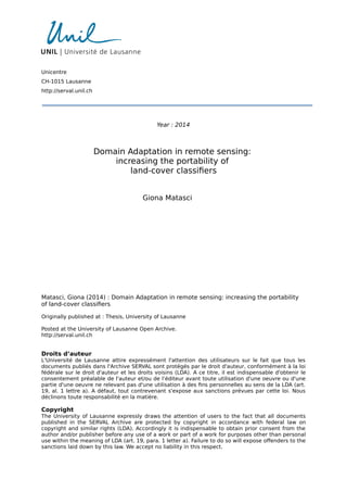
- 38. 2.3 passive remote sensing imaging systems 15 2007, Schaepman-Strub et al., 2006]. Such a function describes the ratio of outgoing to incoming radiance as a function of incident (related to the sun) and view (related to the sensor) angles. Finally, since the outgoing radiance still has to traverse the atmosphere Unscattered surface-reflected radiation on its way back to the sensor, to obtain the unscattered surface-reflected at-sensor radiance, we apply a rescaling by the view path (from the ground to the sensing platform) transmittance v (): Lsu = v ()L . (2.4) The view path transmittance depends upon the geometry of the acquisition, as lower values are expected for high off-nadir view angles (low satellite elevation angles) with respect to nadir acquisitions. Indeed, the optical path through the atmosphere is longer in the first situation than in the second. Moreover, note that both transmittance quantities s() and v () (propor-tions between 0 and 1) are highly dependent on the wavelength, as wide radiation absorption bands (around 1.4 and 1.9 μm) occur in the region of the spectrum we are considering. The presence of water vapor and car-bon dioxide in the atmosphere are among the main reasons behind such a phenomenon. The second term of (2.1), the down-scattered surface-reflected skylight Lsd , Surface-reflected skylight up-scattered path radiance accounts for the radiance scattered towards the object by the atmosphere and then reflected upward. The fact that shadowed areas do not appear as completely black is an evidence of this diffuse down-scattering. Instead, the third term of (2.1), the up-scattered path radiance Lsp , relates to the radiation directly reflected at the sensor by the atmospheric layer. For im-age collections taking place with slanted geometries, that is with important off-nadir view angles (long optical path), the path radiance will heavily im-pact the total radiance Ls and Lsp are measured by the detectors. Both Lsd governed by molecular small-scale Rayleigh scattering, and by aerosol and particulate (smog, haze, etc.) Mie scattering. The former type of scattering more than the latter strongly depends on the wavelength, with shortwave radiations (blue and ultraviolet light) being the most affected. 2.3 passive remote sensing imaging systems 2.3.1 The hypercube A passive sensor acquires a remote sensing image by sampling the continu- From radiances to DNs ous EM spectrum within specific wavelengths and recording the associated radiance values. This results in images having multiple spectral bands (or channels), each one responsible for different adjacent parts of the spectrum. Sensors possessing a limited number of wide bands produce multispectral images, whereas instruments with many (more than one hundred) very nar-row bands yield hyperspectral images. Moreover, sensors bearing a single spectral channel having a bandwidth covering the entire VNIR range acquire panchromatic (PAN) images. The spectral resolution of a remote sensing
- 39. 16 remote sensing and earth observation Panchromatic Hyperspectral Pinewood Grassland Sandy soil Silty water Wavelength (μm) 0.5 1.0 DN 0.5 1.0 0 0.5 1.0 Spectral bands Multispectral Figure 2.3: Hypercubes and associated spectral signatures produced by panchro-matic, multispectral and hyperspectral sensors. Top row shows the im-ages with a different number of spectral bands. Bottom row shows examples of the spectral signatures of four land-cover classes. Adapted from http://commons.wikimedia.org/. sensor is defined as the bandwidth of the featured channels (in [nm] gener-ally). This type of data can be thought of as a three-dimensional hypercube s consisting of two spatial coordinates with the spectral wavelength as the third dimension. The actual physical quantity measured by the instrument, the at-sensor radiance L, is converted and stored as an integer value, the Digital Number (DN), usually coded in 8, 11 or 12 bits formats (to obtain the desired radiometric resolution). Spectral Each pixel of the image is described by a sequence of its DN values signature in the different bands, the spectral signature. Depending on the ground-cover constituting the pixel, the spectral signatures can be very different, allowing to finely discriminate the materials. This is exactly the key op-portunity offered by remote sensing systems that is shared with the field of spectroscopy [Clark and Roush, 1984]: the user is enabled to accurately recognize the materials or to derive meaningful parameters describing them. An example Figure 2.3 shows an illustration of the hypercubes resulting from ac-quisitions with the above-mentioned types of sensors. We present the re-lated spectral signature for pixels belonging to the following four land-cover classes: “pinewood”, “grassland”, “sandy soil”, “silty water”. A panchromatic sensor (1st column of the scheme) outputs a gray-scale image composed of a single band in which each pixel is described by one DN value represent-
- 40. 2.3 passive remote sensing imaging systems 17 ing the average radiance recorded over a large portion of the spectrum. A multispectral system (2nd column) instead images the scene through multi-ple spectral channels. When the VNIR region of the spectrum is involved a true color RGB composition of the bands can be created. Each land-cover is described more precisely with several DN values. Hyperspectral sensors (3rd column) collect a large number of bands yielding a hypercube with many layers along the spectral dimension. The measured signatures are very detailed, approaching thus the true reflectance profiles of the consid-ered materials. This permits for instance to effectively discriminate thematic classes such as “pinewood” and “grassland” that were spectrally very similar on both the panchromatic and multispectral images. 2.3.2 Types of sensors The imaging systems mounted on airborne or spaceborne platforms can be Scanning systems and spatial resolution divided into two categories with respect to the scanning procedure utilized to sense the scene. The acquisition always takes place with an in-track motion of the platform (along the flight path). On one side we have pushbroom scanners (e. g. SPOT, QuickBird) that image the full swath width with a linear array of detector elements. On the other side, whiskbroom systems (e. g. Landsat) achieve a sequential cross-track (perpendicular to the flight line) scan by rotating the series of detectors aligned in-track [Schowengerdt, 2007]. In the resulting image, for both types of systems, the pixel centers are spaced by the ground sample distance (GSD), a property often referred to as the spatial resolution of the image. In this respect, we distinguish the recently launched Very High Resolu- VHR multispectral sensors tion (VHR) sensors (e. g. QuickBird, WorldView-2), producing images with a metric or sub-metric spatial resolution ( 5 m), from the previous moder-ate resolution sensors (e. g. MSS/TM/ETM on board the Landsat satellites, ASTER on board the Terra satellite) bearing a decametric spatial resolu-tion [Richards and Jia, 1999]. VHR sensors yield images with a high spatial detail, enabling the end-user with the resources to carry out case studies in-conceivable until the end of the 1990s. However, such high spatial resolution is obtained through a compromise: VHR devices are normally multispectral instruments with bands that are rather broad and mainly cover the VNIR region of the EM spectrum. This type of sensor is often mounted with a panchromatic instrument allowing to achieve the smallest GSD. The PAN band can then be exploited to enhance the spatial resolution of the rest of the bands by means of pansharpening techniques [Brower and Laben, 2000]. Another asset of the advent of VHR sensors is related to the higher temporal resolution of the image collections. Indeed, the increased agility of the plat-forms produces shorter ( 3 days) satellite revisit times (temporal interval between two consecutive acquisitions of the same scene). Finally, note that the recent launch of the WorldView-3 satellite marks a significant change in the spectral properties of VHR instruments. With its 8 SWIR channels at a 3.7 m resolution complementing the 8 VNIR bands already used by
- 41. 18 remote sensing and earth observation Table 2.1: VHR satellites and their sensor characteristics. All native GSD and swath width figures refer to nadir acquisitions. Band names: C = coastal, B = blue, G = green, Y = yellow, R = red, RE = red edge, NIR = near-infrared, NIR2 = near-infrared 2. WorldView-3 CAVIS channels are dedicated calibration bands. For non-US government customers the imagery must be resampled so that the output GSD is 0.5 m. Adapted from http://eijournal.com/2012/buying-optical-satellite-imagery and http://www.satimagingcorp.com/satellite-sensors.html. Satellite Launch year Swath width [km] Native PAN GSD [m] Output PAN-VNIR(- SWIR) GSD [m] Bands IKONOS 1999 11.3 0.82 1 - 4 PAN + 4 VNIR (B, G, R, NIR) QuickBird 2001 16.5 0.61 0.6 - 2.4 PAN + 4 VNIR (B, G, R, NIR) SPOT-5 2002 60 5 2.5 - 10 - 20 PAN + 3 VNIR (G, R, NIR) + 1 SWIR WorldView-1 2007 17.6 0.5 0.5 PAN GeoEye-1 2008 15.2 0.41 0.5 - 2 PAN + 4 VNIR (B, G, R, NIR) WorldView-2 2009 16.4 0.46 0.5 - 2 PAN + 8 VNIR (C, B, G, Y, R, RE, NIR, NIR2) Pléiades 1 2011 20 0.70 0.5 - 2 PAN + 4 VNIR (B, G, R, NIR) SPOT-6 2012 60 1.5 1.5 - 6 PAN + 4 VNIR (B, G, R, NIR) WorldView-3 expected in 2014 13 0.31 0.5 - 1.2 - 3.7 PAN + 8 VNIR + 8 SWIR (+ 12 CAVIS) WorldView-2, this satellite can be deemed the first spaceborne platform car-rying a superspectral VHR sensor. A list of the main VHR satellites/sensors with their characteristics is reported in Tab. 2.1. Hyperspectral Considering the spectral resolution of passive sensors, at the opposite sensors end, we find hyperspectral sensors capable to acquire up to hundreds of narrow bands finely sampling the spectrum [Goetz et al., 1985, Plaza et al., 2009]. Such type of instruments, when mounted on satellite platforms, never reaches the spatial resolution of multispectral sensors. In fact, since the spec-tral resolution is much higher ( 10 nm wide bands), to register enough energy for each pixel, the GSD needs to be larger ( 15-20 m). The list of spaceborne hyperspectral sensors is quite short. The two main instances consist of Hyperion (30 m GSD, 220 spectral bands in the VNIR to SWIR region) [Folkman et al., 2001] on board NASA’s EO-1 satellite and CHRIS (highest GSD of 17 m, programmable up to 62 spectral bands in the VNIR region) [Barnsley et al., 2004] on board ESA’s PROBA satellite. On the con-trary, for budgetary reasons, the development of airborne sensors has been much more dynamic. In this category, a non-exhaustive list of instruments comprises ROSIS (115 VNIR spectral channels) [Mueller et al., 2002] oper-ated by DLR, AVIRIS (224 VNIR to SWIR spectral channels) [Vane et al., 1993] developed by NASA, APEX (up to 534 VNIR to SWIR bands) [Itten et al., 2008] manufactured by ESA, as well as HyMap (126 VNIR to SWIR spectral channels) [Cocks et al., 1998] and CASI (up to 288 VNIR spectral channels) [Babey and Anger, 1993] engineered by private companies. De-
- 42. 2.4 thematic image classification 19 pending on the flight height of the airplane, the spatial resolution of the acquisitions can be very high ( 1 m). A special class of imaging systems concerns platforms possessing multi- Multi-angle angular capabilities. Indeed, certain instruments have been designed with sensors a collection mode allowing the acquisition of a sequence of images of the same scene with different view angles, an ability that has proved beneficial in many applications (see Chapter 8). This allows to study the BRDF prop-erties of the materials to better understand their nature or to discriminate them more accurately. Among the spaceborne platforms offering such a flex-ible monitoring system there is WorldView-2. Its in-track collection mode builds on the MISR [Diner et al., 1998] and the CHRIS missions, carrying multispectral and hyperspectral sensors, respectively. As the recently de-signed on-board control systems have enabled a rapid re-targeting of the sensor to a wide range of look angles, the angular sampling density has been highly augmented with respect to earlier systems. Within a time frame of a few minutes, WorldView-2 can acquire angular sequences of tens of images of the same scene along an in-track collection path with off-nadir angles up to 45. Some examples of the images acquired by the instruments mentioned in this Section can be found in Appendix B reporting the datasets used in this Thesis. 2.4 thematic image classification 2.4.1 Interpretation of the scene The final goal of the processing of remote sensing imagery is the extraction From photo-interpretation to image processing of meaningful information helping the end-user in understanding the nat-ural or anthropic phenomena occurring at the surface of the Earth [Caloz and Collet, 2001]. In the early years of remote sensing, such a crucial task has ever been carried out via photo-interpretation: aerial photographs were transformed into maps by human experts capable of recognizing forms, ob-jects, and textures on the ground. With the advent of digital image processing techniques [Gonzalez and Woods, 2002], the automation of this task is now a reality. The knowledge of the analyst is complemented by the potential offered by computer programs that sequentially perform the steps needed to obtain the desired output. Expert advice is still decisive as it is required to guide the information extraction process and to assess the quality of the final product. Techniques for tasks such as thematic classification, physical parameter Land-cover retrieval via regression, data fusion, unmixing or target detection are nowa- classification days widely investigated to derive useful georeferenced information from remotely sensed imagery [Bioucas-Dias et al., 2013]. Although many other types of spatial layers can be obtained (maps of mineral abundances, soil moisture in fields, chlorophyll content of vegetated areas, salinity of the oceans, etc.), one of the primary interests of remote sensing imagery lies
- 43. 20 remote sensing and earth observation in the possibility to (semi-)automatically determine an associated ground-cover for all the pixels in the scene via classification. A suitable thematic partition of the image into land-cover classes is deemed a highly valuable Earth observation product in many fields. For instance, such maps are key for urban planning, precision agriculture, forestry and land management, post-catastrophe assessment, to name a few applications. Classification Taking advantage of methods developed in the research fields of statistics, in remote sensing signal processing and machine learning (see Chapter 3), a large number of classification techniques have been successfully adapted and applied to the analysis of remote sensing data [Mather and Tso, 2003]. The starting point for this exercise is the spectral signature of the pixels recored by the sensor. Based on the vector of observations (typically DNs or reflectances), all of the procedures resort to statistical measures of distance (e. g. Euclidean or Mahalanobis distances) or similarity (e. g. Gaussian or linear kernels) to eventually determine the thematic class label of the pixels. In the following, we briefly review the main families of remote sensing image classification methods. 2.4.2 Overview of the classification approaches by learning paradigm Unsupervised On the one hand, unsupervised learning methods, also referred to as clus-learning tering methods, exclusively utilize the spectral signature to automatically group similar pixels into clusters. This type of techniques does not require labeled pixels: no supervision by the user is needed in the training stage. Such an approach is particularly suited when a rapid mapping is needed, for example in a change detection scenario [Bruzzone and Prieto, 2000, Bruzzone and Cossu, 2003, Volpi et al., 2012b]. Supervised On the other hand, supervised learning methods require a set of exam-learning ples with the associated class labels to be fed to the model for training. In this crucial phase, the model learns the relation between the spectral sig-nature and the thematic class, a rule which will then be used to predict the land-cover at new locations in the prediction phase. After the early works using the parametric Maximum Likelihood classifier [Strahler, 1980], more recently, the remote sensing community has put the focus on powerful non-parametric machine learning methods such as neural networks [Benedikts-son et al., 1990], Support Vector Machine (SVM) and kernel methods in general [Melgani and Bruzzone, 2004, Camps-Valls and Bruzzone, 2005], random forests [Pal, 2005], Gaussian processes [Bazi and Melgani, 2010], etc. Semisuper- A hybrid category is that of semisupervised learning methods, strategies vised learning whereby the unlabeled data, usually available in large quantities, are lever-aged to define more robustly the class boundaries of the problem at hand. One resorts to such techniques when the labeled samples are scarce and the consideration of the underlying structure of the data provides help in regu-larizing the solution. Examples of such methods can be found in Bruzzone et al. [2006], Camps-Valls et al. [2007], Tuia and Camps-Valls [2009].
- 44. 2.5 working with multiple images 21 2.4.3 Extensions of the classic paradigms Within the supervised learning paradigm, we find the field of Active Learning Active (AL), a booming research topic in the remote sensing community in the Learning recent years. The underlying principle consists of the incremental addition of new samples to the training set. A dedicated search strategy is devised such that the selected pixels, after manual labeling by the operator, will maximally improve the classification accuracy (compared to a random or stratified sampling of the image). Thorough reviews of the various sampling schemes proposed for the analysis of remotely sensed images can be found in Tuia et al. [2011b], Crawford et al. [2013]. Parallel to the above developments, the inclusion of spatial information in Spatial-spectral classification the thematic classification process has proven highly valuable [Wang et al., 1983]. Integrating a description of the arrangement of pixel values in the geographical space allows to produce smoother maps, with a higher spatial coherence, especially when considering VHR images [Tuia et al., 2009a]. These approaches are based on segmentation [Huang and Zhang, 2008], Markov random fields [Jhung and Swain, 1996, Moser et al., 2013], texture extracted through the gray level co-occurrence matrix [Haralick et al., 1973], mathematical morphology [Pesaresi and Benediktsson, 2001] and, more re-cently, morphological attribute filters [Dalla Mura et al., 2010]. 2.5 working with multiple images 2.5.1 Model portability Large-scale Earth observation problems are generally tackled by the practi- Temporal and spatial large-scale problems tioner by making use of multiple remotely sensed images. On the one hand, the mentioned scale can be temporal, with the analysis of time series of im-ages of the same region to monitor the evolution of the land-cover [Jonsson and Eklundh, 2002] or with dedicated change detection studies [Coppin and Bauer, 1996]. On the other hand, the scale can be spatial, with regional or continental land-cover mapping efforts [Woodcock et al., 2001, Knorn et al., 2009]. The common requirement of all these large-scale applications is that the employed images bear similar radiometric characteristics. This means that the same land-covers/objects appear with comparable values on differ-ent images. However, the fact of being forced to resort to a large number of different acquisitions to be jointly analyzed makes this requirement hardly met in practice, which is exactly the situation this Thesis considers. In the context of thematic classification, the initial efforts by the com- Model portability: from signature extension toward DA munity to answer these questions were undertaken in the area of remote sensing named signature extension [Olthof et al., 2005] (more details in Sec-tion 5.2.1). Such a research field, by taking advantage of the latest advances in statistics and machine learning, has recently evolved to a more mature and specific discipline now usually referred to as Domain Adaptation (DA) [Pan and Yang, 2010] (see Chapter 4). The problem that both disciplines aim to
- 45. 22 remote sensing and earth observation solve consists in modeling and extending the relation between spectral sig-natures and thematic classes collected over several scenes, reaching thus an adequate land-cover classification model portability. The particular case of sample selection bias considers the extension to the whole scene of models based on localized ground truth data sampled on a small portion of it. By matching the pixel signatures observed on a source image (or part of it) where we have labels to those of a target image where (usually) we do not, classifiers trained on the first can be used to accurately predict the classes of the second [Bruzzone and Marconcini, 2010]. 2.5.2 The issues Factors Hereafter we present an overview of the factors limiting the portability of causing radiometric differences classifiers across multiple or vast acquisitions. In general, heavy radiomet-ric differences usually exist between images taken over spatially separate regions at different time instants, even if the acquisition is carried out by the same Earth observation system. To a lesser extent, these effects also concern single images having a large extent over complex landscapes or with a heterogeneous nature of the land-cover. The main factors affecting the radiometry of the images are the following. • Changes in atmospheric conditions (composition of the atmosphere, cloud cover, haze, etc.) [Schowengerdt, 2007]. • Differences in illumination (solar elevation angle depending on season and time of the acquisition) [Schowengerdt, 2007]. • Topography controlling terrain shading [Teillet et al., 1982]. • Seasonal variations affecting the phenology of vegetation [Reed et al., 1994]. • Changes in the acquisition geometry [Longbotham et al., 2012a] (stud-ied in more detail in Chapter 8 for VHR images): – longer optical depth of the atmosphere at large off-nadir an-gles (low satellite elevation angles) leading to an increased up-scattered path radiance due to Rayleigh scattering, – varying angular distribution of the reflectance (small-scale BRDF effects), – solar observational cross-section effects responsible for changes in the reflectance of the objects with non-flat surfaces (e. g. pitched roofs, trees), – solar forward and backward scattering regimes (determined by satellite and sun positions) affecting the last two points.
- 46. 2.5 working with multiple images 23 2.5.3 Radiometric normalization In the case of thematic classification involving multiple acquisitions, a pre- Radiometric processing to normalize the images is needed. For instance, a blending of needs the set of images via mosaicking procedures [Homer et al., 1997] is desirable in order to obtain a vast surface coverage with one single large composite image having homogeneous characteristics. All the same, in change detec-tion applications, most methodologies require comparable radiometries for the bi-temporal images to be profitably jointly analyzed. The possible solu-tions to make the images more radiometrically similar to each other, or to adjust them over their whole extent, can be classified into two categories: absolute or relative radiometric normalization strategies. 2.5.3.1 Absolute normalization strategies In the first category, we find traditional physically-based radiometric cali- Radiometric bration approaches [Schowengerdt, 2007]. These procedures are targeted at calibration compensating atmospheric, solar and topographic effects with the ultimate purpose of retrieving the original surface reflectance () of the materi-als. The calibration is a three-stage sequence. The first level of calibration entails the conversion of the raw DNs to the original at-sensor radiance values. This step can be accomplished by knowing the sensor gain and off-set parameters, specific to each acquisition and to each spectral channel. The second level consists of a transformation retrieving the corresponding radiance at the Earth’s surface, the surface radiance L. Such a process is generally referred to as atmospheric compensation. Atmospheric By assuming the term Lsd compensation as equal to zero (no surface-reflected skylight), Eq. (2.1) of page 13 turns into Ls + Lsp = Lsu = v ()L + Lsp . (2.5) Solving for L we obtain L = Ls −Lsp v () . (2.6) In practice, if considering a unit view path transmittance v (), this reduces to estimating the upwelling path radiance Lsp induced by the atmosphere. Well-known approaches such as dark object subtraction [Chavez, 1988] ac-tually utilize such a simplification to correct the signal by subtracting from every pixel the radiance measured over dark regions as deep lakes or heav-ily shadowed areas. The third and final step needed to derive () is the solar and topographic compensation. Such a conversion transforms the pre-viously computed surface radiance L taking into account the solar path transmittance s(), the exo-atmospheric solar spectral irradiance E0 and the incident angle (x, y). This last term is calculated based on the position of the sun and the topography, which is subject to the availability of a Dig-ital Elevation Model (DEM). A sophisticated yet widely adopted algorithm allowing the calculation of the () values is represented by Fast Line-of- sight Atmospheric Analysis of Spectral Hypercubes (FLAASH) [Cooley
- 47. 24 remote sensing and earth observation et al., 2002]. This procedure is essentially aimed at adjusting the distortions caused by the atmosphere. The compensation technique is implemented in a software package based on the MODTRAN program [Berk et al., 1987] and is valid only in the visible through SWIR spectrum (up to 3 μm). It is largely automatized but is highly dependent on numerous parameters of the atmosphere (water vapor content, aerosol optical thickness, etc.). Once () is recovered, being this an inherent property of the materials at the surface of the Earth, the quantity grants more robust inter-image comparisons and analyses (portability of land-cover classifiers across acquisitions, change detection, etc.). In general, we draw the attention to the fact that effective compensation approaches are very demanding processes in terms of prior knowledge required, in particular for the atmospheric correction step (an-cillary information and parameters required by physical models). Moreover, issues such as BRDF effects remain unaccounted for with this type of trans-formation. This is critical as these angular phenomena are emphasized in the acquisitions carried out by the latest VHR systems. Comparisons For a comparison of absolute and relative atmospheric compensation approaches applied to moderate resolution imagery we refer the reader to Song et al. [2001]. Instead, concerning VHR images, Pacifici et al. [2014] investigate the suitability of both raw DNs and surface reflectance data when undertaking change detection or multitemporal classification studies. By examining a long temporal series of acquisitions over the same scene, the authors point out the importance of resorting to physical quantities guaranteeing an increased invariance to changes in viewing geometry or in illumination and atmospheric conditions. 2.5.3.2 Relative normalization strategies A statistical On the other hand, relative normalization strategies are founded on statis-approach tical approaches. They are based on comparisons among images so that each acquisition is modified with respect to a reference image. One fre-quent requirement for these approaches is that the sensor having collected the images should remain the same, even though cross-sensor techniques have been developed, especially in change detection studies [Nielsen et al., 1998]. Pseudo- For instance, regression analyses relying on radiometrically invariant invariant features objects (called pseudo-invariant features) such as man-made structures have often been employed to obtain a scene-to-scene radiometric normalization. Examples of this line of work can be found in Schott et al. [1988], Canty et al. [2004]. Classic Alternatively, rather simple image processing techniques such as His-histogram matching togram Matching (HM) [Gonzalez and Woods, 2002] can be adopted. With this non-linear transform, the shape of the cumulative histogram of the im-age of interest is matched, band by band, to that of a reference image. The univariate cumulative distribution function (CDF) modification acts as fol-lows. Considering a single band, for a given pixel value xi belonging to the image to be adjusted possessing a CDF F(X), the method looks for the
- 48. 2.5 working with multiple images 25 Figure 2.4: Illustration of the HM procedure. cumulative histogram value F(xi) and finds the corresponding value in the CDF G(X) of the reference image, i. e. G(xj ) = F(xi). The new pixel value x i , is obtained by replacing the input pixel value xi with xj , thus appropri-ately reshaping the CDF of the image to be modified. In mathematical terms we can express this as x i = G−1(F(xi)) . (2.7) Figure 2.4 graphically illustrates the principle. The appropriate computation of the histograms to rely upon for the match- Extensions ing process can be challenging. They are usually computed by resorting to a discrete binning of the intensity values. Thus, the influence of the choice of number of bins, their width and placement can affect the final results. In response to these shortcomings, Gevers and Stokman [2004] propose to use a kernel density estimator. Recently, a more sophisticated HM technique has been proposed in Inamdar et al. [2008]. The authors present a multivari-ate extension of the univariate matching which accounts for the correlation between bands by matching the joint distributions of the images. With the same objective in mind, Zheng et al. [2012] introduce a procedure they call Joint Histogram Matching . A transformation of the images from the original color space to the CIE Lab space [McLaren, 1976] is applied before combin-ing a univariate matching of the lightness dimension (L) of the two images with a matching of the joint 2-D histogram of the two color planes (a and b).
- 50. Part II LE A RNING F ROM DATA WI TH CHANGING DI ST R IBUT IONS
- 52. 3 MA CHINE L EA RNING Outline: In this Chapter, we present an overview of the funda-mental concepts of machine learning and a description of the main techniques and approaches that will be used in this The-sis. First, the introductory Section 3.1 provides a definition and lists the main applications of the subject area. Afterwards, Sec-tion 3.2 will review the principal ways of learning from data and will introduce the statistical theory that is the foundation for all the predictive approaches adopted in this Thesis. In Section 3.3, we will focus on the Support Vector Machine classification tech-nique and on the properties of the related kernel functions. Sec-tion 3.4 introduces the Linear Discriminant Analysis framework both for classification and for Feature Extraction. Section 3.5 addresses the latter topic in more details, namely by present-ing two widely used techniques of unsupervised dimensionality reduction. In the end, the Dictionary Learning approach for the sparse representation of signals is examined in Section 3.6. 3.1 introduction Machine learning can be thought of as an approach to learn from examples Definition the dependencies existing in the data in order to perform a predictive task. Algorithms are designed such that the learning procedure takes place in a data-driven way: once the learning machine has been trained, it is used to predict the future output of the system at hand based on the related input samples [Cherkassky and Mulier, 2007]. Generally speaking, contrary to classic parametric methods developed in statistics, assumptions concerning data probability distributions are not required by machine learning proce-dures. Moreover, with these flexible methods, human prior knowledge can be integrated with more efficacy in the learning process, often resulting in a beneficial user-machine interaction. This rapidly growing research field can be placed at the interface between the disciplines of computer science and statistics. The terms artificial intelligence, pattern recognition and data min-ing also come into play when describing such a multifaceted science. Good foundations on the topic of machine learning and detailed explanations of the main families of techniques can be found in Bishop [2006], Cherkassky and Mulier [2007]. Machine learning has many real-world applications in diverse fields Applications such as biology (biosequences analyses, gene expression, etc.), medicine (e. g. cancer diagnosis), chemistry (e. g. analytical chemistry), finance (e. g. stock market forecasting), web and text analysis (automatic transla- 29
- 53. 30 machine learning tion, web pages categorization, hand-written character recognition, etc.). In the area of environmental sciences, the application of these develop-ments concerns domains such as spatial interpolation (e. g. soil mapping), weather forecasting (e. g. radar-based nowcasting), natural hazards assess-ment (e. g. avalanches, landslides), etc. [Kanevski et al., 2008, 2009]. More specifically, data-driven methodologies naturally find a synergy within the study of geospatial data and remotely sensed images make no exception. Indeed, the breakthroughs occurred within the machine learning commu-nity have almost directly been put into practice to assist the practitioner in image analysis [Swain, 1972, Davis et al., 1978]. Especially in the last decade, the knowledge exchange and collaboration between these two scien-tific communities has flourished, leading to highly promising developments in the automated processing of remote sensing images [Camps-Valls, 2009, Camps-Valls et al., 2011, 2014, Tuia et al., 2014]. 3.2 learning from data Two main Data-driven machine learning approaches can be mainly classified into two families distinct categories: supervised and unsupervised learning. The techniques belonging to the former family aim at developing a model describing the input-output relationships existing in the data at hand based on the training set comprised of input sample-output label pairs. On the contrary, the latter represents an ensemble of approaches devised to extract information about the process having generated the data by solely resorting to the input samples. For the purposes of this Thesis, in the following we will consider only the supervised learning paradigm. 3.2.1 Supervised learning Notation Formally, supervised machine learning seeks relations between an input space X 2 Rd and an output space Y 2 R. To this end, a training set D = {X, Y } = {(xi, yi)}ni =1 composed of n labeled data samples is available to the system. Each one of these samples is described by a d-dimensional input vector x and presents a related known output y, the label. Such sample pairs are drawn from a given unknown joint probability distribution P(X, Y ) of variables X and labels Y . The set of input variables X will also be referred to simply as a dataset, whereas the above-defined D will denote more precisely a labeled dataset. In this Thesis, a notation using matrices will often be adopted, as many equations involving matrix calculus will appear. In such cases, a n×d data matrix X = [x1, : : : , xn] composed of the n column vectors xi of length d belonging to dataset X will be used to represent the available training set. The Starting from the input vector x, the goal is find a predictive function supervised approach f (x) linking the input space X to the output space Y to correctly predict the associated y value. Once the appropriate model is learned, the prediction on new data takes places as follows. For each sample xtest belonging to an