
Recomendados
Mais conteúdo relacionado
Mais procurados
Mais procurados (20)
Destaque
Destaque (19)
Semelhante a Galician estuary ecosystem and resources
Semelhante a Galician estuary ecosystem and resources (20)
Último
Último (20)
Galician estuary ecosystem and resources
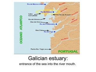
- 1. Galician estuary: entrance of the sea into the river mouth.
- 2. Main factors in the formation of the estuaries: 1 . TECTONIC . The tectonic efforts created a faults system in three directions that determinated the orientation of the North estuaries (Rías Altas) (NE-SW), Middle and South (Rías Baixas) (SW-NE). 2. FLUVIAL . The fluvial courses used these faults zones and eroded deeply the beds of the rivers. This happened in a cold period in which the coast line was off shore. 3. CLIMATIC . The change to a warm period caused ice fusion and a rise in the level of the sea, flooding the end of the fluvial valleys previously dug out,. The estuaries were created. Coast level in glaciar period Rise of the level of water in the deglaciation Current level coast
- 3. Upwelling The wind that blows from the earth to the sea removes the warm superficial water allowing the rise of the cold deep water with a lot of nutrients. The deep water has a lot of nutrients such as nitrates and phosphates which are the result of the decomposition of the organic matter that came from the superficial water. When these nutrients are carried by the cold water to the surface, they are used by the phytoplankton for (with CO2 and light) making the photosynthesis. This growth of the primary producers carries all the food chain of the ecosystem. Phytoplankton -> Filtering Zooplankton>Predator Zooplankton ->Filtering Fishes-> Predator Fishes.
- 4. The most important upwelling zones in the world match up with that phenomenon and they are the most productive fhising areas. They are, besides the Galician short estuary tidal, the coast of Namibia and South Africa, the coast of Perú and Chile in South America…
- 5. SEA RESOURCES RECURSOS DO MAR
- 6. Bivalve Mollusks: MUSSELS Filtering bivalve mollusks which live in highly populated communities fixed over a substratum. They are in tidal zones and below them, but always in shallow zones. We can find them on the rocks but the traditional method to produce them is the growing in bed. In this system, the larvae of the mussels are fixed on the ropes that hang from a floating plattform. These beds are placed inside the estuary tidal, where the mussels will stay completely submerged until they get their commercial weight.
- 7. Bivalve Mollusks:CLAMS Bivalve mollusks with a smooth shell and different colors which live buried in shallow sandy areas. Gathering shellfish on foot is the traditional way to get the mollusks on the beach (clams, cockle) or on the rocks (mussels, goose barnacle) during the low tide. It is also called « ir á seca». Gathering afloat shellfish is the proper method to capture mollusks that grow below the water. The fisherman uses a device ( raño ) with a net and a very long handle (8-9 metres) which is thrown into the sea and dragged through the sandy floor towards the boat. The shellfish is kept into the net. It is also called “ ir ao raño”.
- 11. Punta Carreirón , in the island of Arousa, belongs to the Complexo intermareal Umia-O Grove. In this area, the fresh water from the Umia river and the salty waters from the Atlantic ocean mix together creating an amazing group of ecosystems composed of big sandy areas, intertidal plains, marshlands, and the only coast lake which exists in Pontevedra. It has included a lot of protection figures as Ramsar zone, ZEPA, LIC ….
- 12. Dune vegetation. Adaptations . The plants of dune are exposed to the hard environmental conditions; wind, salinity and high insolation. To get an appropiate adaptation to them, they develop strategies such as the white pilosity, deep roots and succulent leaves. Othantus maritimus (carrascas de San Xoán) . White pilosity. Eryngium maritimum (cardo de ribeira) . Up to five metres long roots and leaves with thorns. Cakile maritima (eiruga de mar). Succulent leaves.
- 15. COME AND VISIT US.