Resolutions and Sensors of Satellites
•Transferir como PPTX, PDF•
0 gostou•2,147 visualizações

http://blog.daum.net/geoscience/1571

Recomendados
Mais conteúdo relacionado
Mais de Byeong-Hyeok Yu
Mais de Byeong-Hyeok Yu (20)
Resolutions and Sensors of Satellites
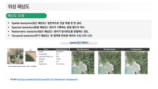
- 1. Spatial resolution(공간 해상도): 일반적으로 단일 픽셀 한 면 길이. Spectral resolution(분광 해상도): 센서가 기록하는 분광 밴드의 개수. Radiometric resolution(방사 해상도): 센서가 방사휘도를 분할하는 정도. Temporal resolution(주기 해상도): 한 영역에 연속된 데이터 수집 간의 시간. http://gsp.humboldt.edu/OLM/Courses/GSP_216_Online/lesson3-1/resolution.html
- 2. Spatial resolution(공간 해상도): 일반적으로 단일 픽셀 한 면 길이. Spectral resolution(분광 해상도): 센서가 기록하는 분광 밴드의 개수. Radiometric resolution(방사 해상도): 센서가 방사휘도를 분할하는 정도. Temporal resolution(주기 해상도): 한 영역에 연속된 데이터 수집 간의 시간.
- 3. Spatial resolution(공간 해상도): 일반적으로 단일 픽셀 한 면 길이. Spectral resolution(분광 해상도): 센서가 기록하는 분광 밴드의 개수. Radiometric resolution(방사 해상도): 센서가 방사휘도를 분할하는 정도. Temporal resolution(주기 해상도): 한 영역에 연속된 데이터 수집 간의 시간.
- 4. Landsat 1: 1972년 7월 23일 (MSS 센서) Landsat 2: 1975년 1월 22일 (MSS 센서) Landsat 3: 1978년 3월 5일 (MSS 센서) Landsat 4: 1982년 7월 16일 (TM 센서, MSS 센서) Landsat 5: 1984년 3월 1일 (TM 센서, MSS 센서) Landsat 6: 1993년 10월 5일, 궤도 도달 실패 Landsat 7: 1999년 4월 15일, 2003년 5월 SLC 고장 (ETM+ 센서) Landsat 8: 2013년 2월 11일 (OLI / TIRS 센서) https://www.fws.gov/gisdownloads/R8/individual/Justin/RS_presentations/03%20Landsat%20Legacy.pptx
- 9. Sentinel-1A: 2014년 4월 3일 (SAR 센서) Sentinel-2A: 2015년 6월 23일 (MSI 센서) Sentinel-3A: 2016년 2월 16일 (OLCI /SLSTR /SRAL 센서) Sentinel-1B: 2016년 4월 25일 (SAR 센서) Sentinel-2B: 2017년 3월 7일 (MSI 센서) Sentinel-3B: 2018년 4월 25일 (OLCI / SLSTR / SRAL 센서) https://sentinel.esa.int/web/sentinel/user-guides/sentinel-1-sar