Mutha river basin report by dr.vadagbalkar
•Transferir como DOCX, PDF•
2 gostaram•2,983 visualizações

In response to- MoEF team visits Devnadi, Mutha river on 3rd Nov.2011 PUNE: An inspection team constituted by the Union ministry of environment and forests visited the Devnadi (a five-km-long stream that flows into the Mula river) and the Mutha river bed in Vitthalwadi on Thursday. Environmentalists and activists in the city drew the attention of the three-member team to various interventions, including the storm water drainage project, that are severely impacting the natural water bodies like nullahs and rivers in the city.

Recomendados
Recomendados
Mais conteúdo relacionado
Destaque
Mais de SHRINIVAS VADAGBALKAR
Mais de SHRINIVAS VADAGBALKAR (7)
Último
Último (20)
Mutha river basin report by dr.vadagbalkar
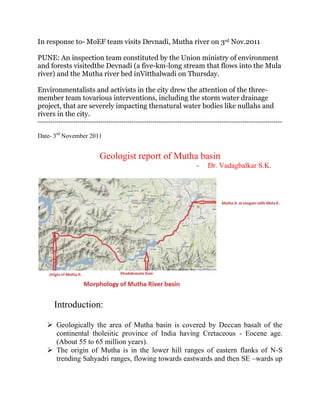
- 1. In response to- MoEF team visits Devnadi, Mutha river on 3rd Nov.2011 PUNE: An inspection team constituted by the Union ministry of environment and forests visitedthe Devnadi (a five-km-long stream that flows into the Mula river) and the Mutha river bed inVitthalwadi on Thursday. Environmentalists and activists in the city drew the attention of the three- member team tovarious interventions, including the storm water drainage project, that are severely impacting thenatural water bodies like nullahs and rivers in the city. --------------------------------------------------------------------------------------------------------------------- Date- 3rd November 2011 Geologist report of Mutha basin - Dr. Vadagbalkar S.K. Introduction: Geologically the area of Mutha basin is covered by Deccan basalt of the continental tholeiitic province of India having Cretaceous - Eocene age. (About 55 to 65 million years). The origin of Mutha is in the lower hill ranges of eastern flanks of N-S trending Sahyadri ranges, flowing towards eastwards and then SE –wards up
- 2. to Khadakwasala and then turning in NE direction to flow in nearly plain area till it meets Mula river at Sangam in Pune city. Numbers of lava flows are recognized along with various flow units. The thickness of the various flow units in the lava flows vary laterally & vertically throughout the basin area. Due to which the ground water availability vary. Heterogeneity in the distribution of fracture pattern, weathering mantle etc. has hindered the movement of groundwater, which has resulted in separation of water pockets of different dimensions with variable storage. There is no continuity in groundwater flow mainly at deeper depths. Recharging of upper shallow aquifer during monsoon, takes place. Mutha nadi basin after Khadakwasala dam- largely consists of moderate to gently sloping plain, with massive rock- basalts domination. Soil cover is thin to moderately thick. Due to hard and massive rock terrain, the majority of river bed is relatively shallow, rocky and wide. Thereby scientifically there is less amount of percolation possible in and around the river at depths. Scientifically increase in number of streams if any, will not increase the water quantity but will share and spread the same, as the runoff quantity will be distributed on larger part of land. The runoff quantity will only increase with higher precipitation in relatively short time. Probable Facts: After construction of Khadakwasala dam, the perennial nature of Mutha Nadi must have been modified to a stringer flow, ponding or dry course, at places specifically downstream, except rainy season, by not allowing water to flow from dam storage, to keep pace with increasing demand and reserving mostly all amount of storage water for drinking, agriculture and industrial utilisation of the fastly growing city population. This might have posed depletion in agriculture, greenery etc. to some extent, which has further modified the arable land to dry land. Due to such conditions probably the Mutha Nadi of once wider width is considered of limited wide by the officials and are managing to keep the flow of river in artificial walled channel.
- 3. Explosive population growth, poor urban management, urban congestion, and indiscriminate building in green belt zones all add on to shortening the fuse for disaster. With overpopulation peoples have buildings- homes on waterways and in green belts, disrupting and blocking the natural drainage system. Despite bans on construction in the river lands, the flood prone areas received over crowding of rural-urban migration in the wake of the globalization and modernization with upcoming of Pune as electronic hub- computer city. The population spread over skirting the Pune city, knowingly or unknowingly violating the rules and natural limitations. This has further helped in permitting construction/ encroachment within the naturally existing river bed. Observational analysis It seems that leaving the natural discourses intact following the natural slope of the land is not considered during the planning and its implementation by the authorities. Presently the region is full of buildings and roads which block natural waterways and basins. Due to reduction in width of the river along with decrease in depth of the course of river i.e. shrinkage in stream dimensions has increased the fear for flash floods especially in low line areas surrounding the river banks downstream. During Monsoon season when there is heavy down pours in small time, then flash floods occur during which water spread along the ground encircling the buildings, houses, roads etc. as the runoff is not channelized due to obstructions. Explanations of some facts: The land around a river is called a watershed. When rain falls on a watershed, the land "sheds" the water into the river. "It's almost like a
- 4. funnel," Richards says. "It's collecting water over a broad area and funneling it this narrow strip that is the river." There are two basic types of floods. In a regular river flood, water slowly climbs over the edges of a river. The more dangerous type, a flash flood, occurs when a wall of water quickly sweeps over an area. Buildings, parking lots and roads, replace grass and dirt with concrete. Under normal circumstances, soil acts like a sponge and soaks up a fair portion of rainwater. But in crowded towns and cities, rainwater flows into storm sewers and drainage ditches, and, at times, overloads them. An urban area can be flooded by an amount of rainfall that would have had no impact in a rural area. The large-scale excavations being carried out in various projects generate thousands of tons of debris, which is conveniently dumped in or around the dry channel, which get washed away further downstream during rain reducing their carrying capacity drastically, besides destroying all vegetation along slopes if any. The debris raises the bed level and the flow is often obstructed during heavy rain and as a result of which the water changes its course causing widespread devastation. The environment impact assessment and the environment management plans do not take into considerations these factors. The springs are the sources of rivers and the spring in turn fed by the ground water. Recharging of the groundwater in the vicinity of the spring is produced by the annual rainfall. Technically this phenomenon is described as the “Replenishment of the catchment area of the rivers”. The rivers originate as a natural consequence, their direction of flow are preferred ones. This Aspect must be considered before trying to divert their direction of courses, or inter-linking them, because such an action is likely to create imbalance. It might upset the natural balance and adversely affect the environment. It is dangerous to artificially monitor the natural courses of the river. Contact: Dr.Vadagbalkar S.K. I/C Principal, Associate professor and HOD, Department of Geology and Geochemistry, Dayanand College of Arts and Science, Solapur-413002, Maharashtra, India EMAIL- Vadagbalkar@gmail.com
- 5. Satellite imagery of Part of Mutha river basin in 2010 Satellite imagery of Part of Mutha river basin in 2003