Osher Lifelong Learning at UNM - Vikings Lecture 4
•Transferir como PPT, PDF•
1 gostou•637 visualizações

Presentatio

Recomendados
Mais conteúdo relacionado
Mais procurados
Mais procurados (20)
Semelhante a Osher Lifelong Learning at UNM - Vikings Lecture 4
Semelhante a Osher Lifelong Learning at UNM - Vikings Lecture 4 (20)
Mais de UNM Continuing Education
Mais de UNM Continuing Education (20)
Último
Último (20)
Osher Lifelong Learning at UNM - Vikings Lecture 4
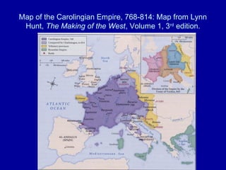
- 1. Map of the Carolingian Empire, 768-814: Map from Lynn Hunt, The Making of the West, Volume 1, 3rd edition.
- 2. Maps of Viking attacks in France: left map from Vikings: the North Atlantic Saga, edited by Fitzhugh and Ward; right map from Gwyn Jones, A History of the Vikings.
- 3. Maps of Normandy: maps from Robert Ferguson, The Vikings: a History.
- 4. The Vikings in Spain: left map from Barbara Rosenwein, A Short History of the Middle Ages; right map from Robert Ferguson, The Vikings: a History.
- 5. Vikings and Franks: left—an image of a Viking ship from the Life of Saint Aubin, 9th century; right—crucifix discovered in a 9th century grave from Birka, Sweden. Images from Vikings: the North Atlantic Saga, edited by Fitzhugh and Ward.
- 6. Evidence of Vikings in France: left top—Frankish sword mounts; left bottom—ax and spearhead of Viking warrriors; right—the Hon Hoard. Images from Vikings: the North Atlantic Saga, edited by Fitzhugh and Ward.
- 7. Vikings in Normandy: left—statue of Rollo; right—statue of Richard II le Bon (the Good), both sculpted by Louis Rochet, 1851, at Falaise, France.
- 8. Norman coins: left—coin of William I Longsword, reading Wilelmus (top) Rotomagus (bottom); right—coin of Richard I, reading Ricardus (top) Rotomagus (bottom). Rotomagus was the Latin for Rouen. Left images from Jean Renaud, Les Vikings et la Normandie; right images from www.home.ekard.edu.
- 9. Monastery of Mont Sant Michel. Images from Wikipedia and Wikimedia Commons.
- 10. Monastery of Fécamp. Image from Wikipedia.
- 11. Evidence of Viking contact with Islamic culture: left—Arabic coins recovered in Scandinavia; right—Arabic coins, weights, strike-light, and dress pin found in a Viking grave. Images from Vikings: the North Atlantic Saga, edited by Fitzhugh and Ward.
Notas do Editor
- Map from Barbara Rosenwein, A Short History of the Middle Ages.
- Coin on top reads Wilelmus; coin on bottom reads Rotomagus, which was the Latin for Rouen.