TerraPop Brief Overview (2 slides)
•Transferir como PPTX, PDF•
0 gostou•1,768 visualizações


Recomendados
Recomendados
Mais conteúdo relacionado
Mais procurados
Mais procurados (10)
Último
Último (20)
TerraPop Brief Overview (2 slides)
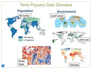
- 1. Terra Populus Data Domains Population Environment Microdata Land cover Individuals and households Land use Areal Data Climate
- 2. Location-Based Integration Individuals and households with their environmental and social context County ID Mean Ann. Max. Ann. Rent, Rent, Own, Own, Temp. Precip. Rural Urban Rural Urban Summarized G17003100001 21.2 768 3129 1063 637 365 population and G17003100002 23.4 589 2949 1075 1469 717 Rasters of G17003100003 24.3 867 3418 1589 1108 617 environmental G17003100004 21.5 943 1882 425 202 142 population and G17003100005 24.1 867 2416 572 426 197 characteristics for G17003100006 24.4 697 2560 934 950 563 environment G17003100007 25.6 701 2126 653 321 215 administrative data districts
Notas do Editor
- Disparate scientific domains – interrelated processesMultiple data formats
- Integration across domains, formats hinges on geographyUsers get any type of data in format useful to themRequires boundary files, boundaries harmonized over time