Lines of Latitude and Longitude
•Transferir como PPT, PDF•
4 gostaram•6,433 visualizações

Year 7 lesson on using lines of latitude and longitude to find places in the world

Recomendados
Mais conteúdo relacionado
Mais procurados
Mais procurados (20)
Destaque
Destaque (20)
Semelhante a Lines of Latitude and Longitude
Semelhante a Lines of Latitude and Longitude (20)
Mais de Steven Heath
Mais de Steven Heath (20)
Último
Último (20)
Lines of Latitude and Longitude
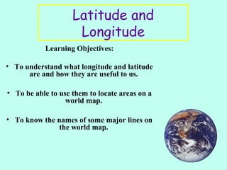
- 1. Latitude and Longitude Learning Objectives: • To understand what longitude and latitude are and how they are useful to us. • To be able to use them to locate areas on a world map. • To know the names of some major lines on the world map.
- 2. A system of lines is used to find the location of any place on the surface of the Earth. Lines of latitudelatitude run in an east-west direction. Lines of longitudelongitude run in a north-south direction. Latitude and longitudeLatitude and longitude
- 3. LatitudeLatitude Latitude (shown as a horizontal line) is measured in degrees north or degrees south of the equator, which is the line around the exact middle of the earth. Lines of latitude are often referred to as parallelsparallels..
- 5. LongitudeLongitude Longitude (shown as a vertical line) is measured in degrees east or west of something called the Prime Meridian. This is the line going from the North Pole to the South Pole and running through the middle of the Greenwich Observatory in London. Lines of longitude are often referred to as meridians.
- 6. International Date Line at 180o Greenwich Meridian LongitudeLongitude
- 7. Your task Use your atlas pages 114-5 or page 43 to find the following lines of longitude and latitude and mark them on your map outline: • Tropic of Cancer • Tropic of Capricorn • Equator • Arctic Circle • Antarctic Circle • Greenwich (Prime) Meridian
- 8. The latitude of ‘a’ is 20ºS…’a’ is 20º south of the Equator. The longitude of ‘a’ is 20ºW…’a’ is 20º west of the Greenwich Meridian. Therefore we write the latitude and longitude of ‘a’ as 20ºS 20ºW. ALWAYS write these first These are lines of longitude a N These are lines of latitude How to use Latitude and longitudeHow to use Latitude and longitude
- 9. These are lines of latitude L i n e s o f L o n g i t u d e
- 10. These are lines of latitude L i n e s o f L o n g i t u d e
Notas do Editor
- You may want to discuss minutes and seconds. Degrees of latitude and longitude can be divided into sixtieths, or minutes ('). Any location on Earth can be described as lying at a certain number of degrees and minutes of latitude either north or south of the equator and at a certain number of degrees and minutes of longitude either east or west of the prime meridian. For example, the United States Capitol in Washington D.C. is at 38 degrees 53 minutes north latitude (38° 53' N.) and 77 degrees 0 minutes west longitude (077° 00' W.). Minutes of latitude and longitude can be divided into sixtieths, or seconds ("), when more precise information on the location of a place is needed, for example, by navigators, surveyors, pilots, or map makers.
- You may want to discuss how longitude came to be calculated. The invention of clocks during the Renaissance was the first step toward the reliable calculation of longitude. The clocks of that era, however, were too inaccurate for use in navigation. In 1714 the British Board of Longitude offered a large cash prize to anyone who could build a clock that would meet certain standards of accuracy throughout long ocean voyages. By 1735 John Harrison, a British clockmaker, had submitted the first of several clocks, the last of which won the prize for him. They were called chronometers. In 1766 Pierre Le Roy, a Frenchman, built a chronometer more accurate than Harrison's. From that time on, sailors have been able to determine longitude accurately by comparing local time with Greenwich mean time (GMT). Shipboard chronometers are set to show GMT. Because of the speed and direction of the Earth's rotation, local time at a given place will be one hour behind GMT for every 15 degrees west of the prime meridian and one hour ahead of GMT for every 15 degrees east of the prime meridian. For example, if a ship's chronometer reads 0300 (3:00 AM) and the ship's local time is 0800 (8:00 AM), the ship is 75 degrees east of Greenwich, or at 75° E. Special radio time signals allow navigators to check the accuracy of their chronometers.
- Use the long and lat hand out in this file if you like – it’s a good crib for later too.
- Useful map to help you explain to students – leave up during exercise? Refer them to handout sheet also.