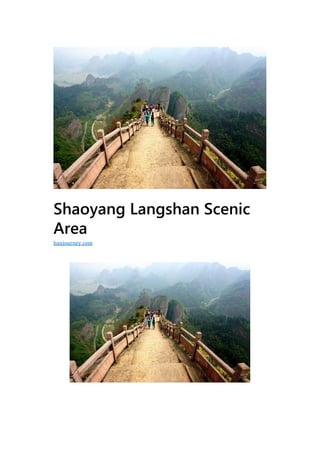
Shaoyang langshan scenic area
•
0 gostou•44 visualizações

Hanjourney.com | Famous tourist attractions in China

Recomendados
Mais conteúdo relacionado
Mais procurados
Mais procurados (20)
Semelhante a Shaoyang langshan scenic area
Semelhante a Shaoyang langshan scenic area (20)
Mais de Journey Han
Mais de Journey Han (20)
Último
Último (20)
Shaoyang langshan scenic area
- 2. Geographic location:And around Lushan Town, Xinning County, southwest of Hunan Province Level:AAAAA Famous scenery:Bajiao Village, Tianyi Alley, Chili Peak, Fuyijiang Suitable for the play season:Best from March to October Langshan is located in and around Langshan Town, Xinning County, Shaoyang City, Hunan Province, in the northwestern side of the hinterland of the Yuechengling Mountain Range, the longest of the Wuling Mountains (the Langshan Mountain, the generalized Langshan Mountain represented by Langshan Mountain). Dagu Mountain spans Xinning County and Resource County, and Langshan Town is located in Xinning County, Hunan Province (South is Resource County). The essence is mainly in the generalized Langshan Scenic Area, which extends to the nearby Bajiaozhai Scenic Spot in Guilin County, Guangxi (the Bajiaozhai area is distributed in two counties, so Xinning Bajiao Village and Resources Bajiao Village). The generalized mountainous area is A composite scenic spot between Xiang and Gui. Langshan Scenic Area is located in Xinning County, Shaoyang City, Hunan Province, and is integrated with the Bajiaozhai Scenic Spot in Guangxi Resources County (Bajiao Village is a Xinning County on one side and a resource county on the other), including Tianyi Lane, Chifeng Peak and Fuyi River. There are six scenic spots in Zixiayu and Tianshengqiao, and 18 scenic spots. There are more than 500 important scenic spots discovered and named. There are three large caves and a virgin forest with a total area of 108 square kilometers. It is a typical Danxia landform and is rare. Environmentally friendly landscape natural scenery area.
- 3. World Natural Heritage, National Geological Park, and National AAAAA Scenic Spot Langshan is located in Xinning County, Shaoyang City, Hunan Province, south of Guangxi Guilin Scenic Area, and echoes Zhangjiajie Scenic Area in the north. “崀” is seen in “Ci Hai”, 曰: “Hey, place name, in Xinning County, Hunan Province.” “崀”, the mountain is also good, can be seen the beauty of Mount Lu. Langshan is not an individual mountain, but a general term for local landscapes. The local mythology and even the local chronicles said: According to legend, when Emperor Sui was patrolling Xinning in the south, seeing this beautiful landscape, he blurted out. “The mountain is good, Langshan , Langshan .” Therefore, Emperor Sui created this “崀” word. Liangshan is a beggar. In August 2016, Langshan Mountain Scenic Spot in Shaoyang City, Hunan Province was approved as a 5A-level scenic spot. Geographical environment Geographic location Langshan Mountain is located in the surrounding area of Langshan Town, Xinning County, Hunan Province, in the northwest side of the hinterland of the Yueling Mountain Range, the longest of the Wuling Mountains. This is the generalized Langshan Mountain represented by Langshan Mountain. The essence is mainly in the generalized Langshan Scenic Area, which extends to the nearby Bajiaozhai Scenic Spot in Guilin County, Guangxi (the Bajiaozhai area is distributed in two counties, so Xinning Bajiaozhai and Resources Bajiao Village), the generalized Langshan The scenic spot is a complex scenic spot between Xiang and Gui.
- 4. Geology The landscape of Langshan Mountain is unique and beautiful. In June 2010, the World Heritage Center’s assessment report on China’s Danxia pointed out: “ Langshan and Danxia Mountain most clearly demonstrated the typical characteristics of Danxia in China.” The Danxia landforms of Langshan Mountain are developed in all ages, strong years and old ages. It is the most representative and most beautiful scenic spot in the Danxia landform in China. The complete red basin Danxia landform, the first in the country. This is a natural Danxia landform museum, which has been praised by geologists as “Danxia Treasure”. Professor Chen Guoda, the founder of Danxia Landforms, visited Langshan in his later years and had a feeling of seeing each other. He wrote a poem: “Half-growth reputation Danxiamei, Fangzhi Langshan than Danxia, the resort has a reason to hate late, and praise North and South double flowers.”. The geologist’s argumentation report said: “The Danxia landforms in Langshan Mountain are vivid and vivid, and they are similar in life, with similar shapes and different modalities. The ups and downs are strong, the scenery is varied, the movements are changed, and the temperament is harmonious and harmonious. Qingshan, green water, The red cliffs are in harmony, such as the height and length of the first lane in the world, the thrill of the octagonal village, the wide span of the first bridge in Asia, the steepness of the candle peak, the beauty of the red wall of Chonghua, the handsomeness of the general stone, the shape of the camel peak, etc. There is nothing in the landscape, and it has a very high appreciation value.”
- 5. Ecological climate Langshan is located in the mid-subtropical humid monsoon climate zone in the central part of the nominated area. It develops and preserves a typical evergreen broad-leaved forest. The original evergreen broad-leaved forest is preserved on the top and ridge of the isolated Danxia mountain, and the spring and summer growth is preserved on the cliff. The herbaceous vegetation ecosystem and the Cotyledon vine ecosystem, which are dormant in autumn and winter and dormant in autumn and winter and grow in autumn and winter, preserve the endemic species of Langshan , which has the unique phenomenon of habitat narrowing. It is Danxia vegetation lineage, succession and The model area of Danxia “ecological island”. Langshan is the only nominated place in the Zhongnanling Mountains, which is the nominated site. It is the essence of the evergreen broad- leaved forest in the humid subtropical zone. The ancient biological groups and rare and endangered species are the most concentrated. The “ecological island” phenomenon of vegetation and the narrow habitat are unique. The most prominent phenomenon is the most complete area of the Danxia plant community succession series. It is a special habitat area for recording the co-evolution (generalized) relationship between the base group of angiosperms and animals (insects). It is an excellent model and experimental site for Danxia Biodiversity Comprehensive Research.
- 6. Natural resources The Danxia nominated site of Langshan Mountain is rich in biodiversity and high natural heritage conservation value. There are 1421 species of wild vascular plants and 150 species of large fungi, including 88 species listed in the Red List of Chinese species; 71 species; 41 species included in CITES; 26 national key protected plants in China, including 3 grade I. The vegetation coverage rate is 85%, the forest greening rate is 75.9%; there are 10 vegetation types and 71 plant groups. There are 26 species of mammals, 94 species of birds, 35 species of reptiles, 19 species of amphibians, 36 species of fish and 816 species of insects, including 270 species listed in the Red List of Chinese species, 40 species listed in IUCN, included in CITES. Of the 27 species, there are 18 national key protections in China.
- 7. Mountain Scenic Area Bajiao Village Bajiaozhai is one of Xinning County and one resource county on the other. Both sides are developed. The name includes Xinning Bajiao Village and Resources Bajiao Village. Also known as Yuntai Mountain, the main peak is 814 meters above sea level. It is named after the main peak has eight angles. The distribution of Danxia landform is more than 40 square kilometers. Its richness of development and the world of taste are rare. It is praised by the relevant experts as the soul of Danxia. “, “first-class taste.” Its mountains blend into the “mountain of the mountains, the steepness of Huashan, the show of Emei”. The eye stone in the scenic spot is completely out of the magical work of nature. It is lifelike and the shape of the gods, so that the tourists and the literati are thinking about it. Looking up at the Bajiao Village from the bottom of the mountain, the peaks standing upright are divided into eight squares, commonly known as eight faucets. The main peak is 818 meters above sea level. It is the highest peak in the Langshan Mountain Scenic Area. It is named Yuntai Mountain because of the floating peaks. Visitors boarded the 1708 stone steps to reach the summit platform, which houses the Yuntai Temple site built in the Ming Dynasty. Boarding a viewing platform of less than two square meters, you can see: one side is Hunan Xinning Danxia Group, one side is Guangxi Danxia Mountain Peak Group; the eight peaks extending to eight sides have six peaks in Hunan, two In Guangxi. The deep and unpredictable canyon of more than ten kilometers constitutes a natural art gallery. The infinite variety of nature also brings the beauty of different forms of the Bajiao Village. When the fog is in the misty sea, the floating mountains are undulating, the mountains are undulating, and the red and red peaks of the size of more than a hundred are rising like a group of giant whales flying and playing, sometimes engulfed by clouds, sometimes revealing the first and the tail, just like ten million
- 8. Whales play in the sea, so the wonderful beauty that is praised by experts as “the soul of Danxia, the national treasure” is called whales and seas. If the rain is fine, the mountains are washed, the mountains are like mountains, the peaks are like snails, and the Chutians are like the waves of the Chinese painter. The steepest corner of the octagonal wall, in the north of the temple ruins: more than 50 meters from the cliff, the peak tip is like a fascia. Here, the clouds are filled all the year round, the mountain wind is angry, and the surrounding cliffs stand, and the deep valleys fall. At the top of this very dangerous corner, there is actually a small temple of mountain gods. The ridge path leading to the faucet is only one foot wide. The scented person must use both hands and feet to advance. This is the famous “faucet incense”. Its thrills are amazing! Only those who are bold and courageous dare to go to the “faucet” to burn incense. Chili peak The earliest scenic spots in the development of the Chili Peak Scenic Area include Camel Peak, Candle Peak, Longkou Chaoyang, Chifeng Peak, Linjiazhai, Yixiantian, and Gonggongzhai. Entering the Chifeng Peak Scenic Area, Linjiazhai has a first-line sky, and the elevation of Linjiazhai Peak is 153.4 meters. The stone lane in the middle of the village is 60 meters long and 40 meters high. The narrowest part of the gap is only 0.5 meters. At noon, the sun shines.
- 9. The above shot into the gap, streaking, colorful. Next to Linjiazhai are two very beautiful canyons, the Lovers Valley and the Ghost Valley. The two valleys are facing each other, and the bottom of the valley is deep and quiet. As the name implies, there is also a beautiful love story. Tracing along the Shitian Xiaoxi, through the Foding Mountain, you can see a big camel that seems to be galloping in the wilderness. This is the “Camel Peak”. It consists of four peaks, the head, the ridge, and the tail. The image is very realistic. The camel is 273 meters long and 187.7 meters high. There is a “candle peak” beside the camel peak, which looks like a red candle straight into the sky. The southwest side of the peak is 217.8 meters high and 400 meters in circumference. The top is round and round, surrounded by steep cliffs, and it is rare. It is rare in Danxia landform. Peculiar landscape. There is a huge natural gap at the foot of the east edge of the candle peak. It is 100 meters long, 50 meters deep and 0.4–1.8 meters wide. The upper and lower rocks are as smooth as a knife. It looks like a giant dragon that is tilted 40 degrees to the east. mouth. Whenever at 11 o’clock in the morning, the sun directly from the Longkou to the bottom of the gap, can form a dragon mouth swallowing beads, the colorful “Longkou Chaoyang” spectacular scene. When the tourists climbed out of the “Longkou”, they boarded the dangerous ladder leading to the camel peak, climbed up the ladder and climbed to the peak of the “Camel Peak”, looking into the distance, and feeling the panoramic view of Qiankun Guangyu. All the red rock boulders form the trend of “excavating the hibiscus and stalking the greenery, and the thousands of feet refer to the Tianmen”, which makes people feel refreshed. The Chifeng Peak, which is opposite to the Camel Peak, is located on the top of the Foding Mountain. He rises up from the ground and rises and squats straight up and down. He is proud of the peaks. The absolute height is 180 meters. The upper and lower sides are about 100 meters long. The stone feet are about 100 meters long. The circumference is about 40 meters long and it is reddish red. It looks like a huge red pepper, which is commonly known as “Xianjiao Drilling Ground”. In 2002, the famous French “Spider Man” Alan Robert climbed the peak of Chili and created a new myth. The Chifeng Peak is also famous in the world.
- 10. Tianyi Lane The Tianyixiang Scenic Area, formerly known as the Niu Niuzhai Scenic Area, is named after its many pairs of stone holes in the shape of a cow nose. “Alley” is the characteristic of this scenic spot. The “first-line sky” represented by “the first lane in the world” is a typical first-line community of Danxia landform. In 2004, it was renamed Tianyixiang Scenic Spot. The main attractions are Tianyi Lane, Yuxian Lane, Horseshoe Lane, Yuxian Bridge, Xianren Bridge, Baizhang Cliff, Moonlight Rock, etc. Known as the first road in the world, the first lane of the world is 238.8 meters. The stone walls on both sides are 80-120 meters high, the widest point is 0.8 meters, and the narrowest part is 0.33 meters. It is a world-class scene. People walk in the curved roadway, such as the bottom of the ground, the battle is endless; on both sides of the cliff facing each other, straight as a knife and axe cut, look up only to see a line of blue sky; and if the time tunnel in the passer-by, experience the charm of beauty and beauty. When the passengers walked out from the dark and narrow stone alleys, they couldn’t help but feel the feeling of being separated from the world. Whenever the sun shines, the walls are shining and wonderful. Inscribed by the academician of the Chinese Academy of Sciences, the first-level professor of Central South University of Technology, and the founder of the mantle theory, Mr. Chen Guoda, he wrote: “The First Lane in the World”, and a poem: “A search for a crack in the Bailing Junling,
- 11. suspected to be on both sides of the giant.” If a person enters the ground in the seam, he will be able to discern the blue sky.” In the southeast corner of Tianyi Lane, there is a Yijunzhai, where the winged Wang Shida is stationed in the army. So far, the Zhaimen and Zhai walls are faintly discernible. In addition, the criss-crossing Horseshoe Lane, Yuxian Lane, and Cuizhu Alley are narrow and quiet, and the two sides of the bamboo are nestled in the east, which makes people linger on their way to return to the top of the ladder. The building is in Tiandong, standing on the Wangjiang Tower and the building outside, and the endless beauty rushes into the eye, which makes people sincerely admire, “Jiangshan is so beautiful.” Tianshengqiao Tianshengqiao Scenic Area is close to Guangxi. It is one of the most unique scenic spots newly discovered in the Langshan Mountain Scenic Area in recent years. The mountain ring is surrounded by water, the peaks are horizontal, the Chibi is opposite, the Wanxiang is blurred, and there are about 50 square kilometers. Xia Chibi group landscape, distinctive landscape resources, outstanding personality, strong comparative advantage, is a good place to develop Danxia sightseeing, eco-tourism, and leisure entertainment. The development of this project is conducive to promoting local economic development
- 12. and is conducive to increasing the reception capacity and capacity of the scenic area. The Langshan Tiansheng Bridge in the scenic spot is 64 meters long, 14 meters wide, 20 meters high and 5 meters thick. The bridge is round and arched. Fuyijiang Fuyishui originated from the Fuyi River in Maoer Mountain, Guangxi. It is the mother river of the people of Langshan . Its waters run through the Langshan Scenic Area, and the mountains and waters are uniquely endowed. The river of the Yiyi River is crystal clear, smooth as a mirror, with a water surface of about 100 meters and a narrow area of more than 70 meters. The strange peaks on both sides of the strait are reflected in the water under the clear blue sky; the sandy beaches on both sides are pure white, the rock willows are continuous, the grass is arguing; the sails in the river are little, the sound of bamboo flute is picturesque. Take the bamboo raft to visit the Fuyi River, passing through No Shadow State, Changdi Liu’an, Qihuxiaotian, Jade Lane, Tuanyu Stone, Warship Stone, Woodpecker Stone, Po Po Rock, Bijia Mountain, Wangu Dike, Liantan Yingyue Many attractions. The natural stone scorpion stands on the low and flat top of the east bank of the Yiyi River. It is a stone pillar formed from the
- 13. development of the Danxia landform to the late stage. The elevation is 399.5 meters, the net height is 75 meters, the circumference is more than 40 meters, and the top and bottom are thick and thick. Slightly thin, far view is like a general who wears a robes, and screams and screams. There is a woodpecker stone on the west bank of the Fuyi River on the slopes of Cuizhu. It is lifelike. The stone consists of a cliff, up to 90 meters high, up and down, high above the head overlooking the river, a sloping feldspar, like a pointed scorpion, the head is round like a roar, a tree stands on the cliff. The mouth is licking the trunk, as if a woodpecker is worming the hole. It is opposite to the woodpecker, and the river is opposite to the river. It is magnificent, with three huge stones. It traverses the east-west direction and slams the river. The captain is 300 meters high and 150 meters high. The front end of the boulder is raised high and the rear end is curved. Tilting, a ship is close to a ship, like a ship formation and sailing. The boating in Fuyi River is more pleasant, boating in clear water, love songs and mutual answers, green mountains and trees on both sides of the river, Tian domain is like a brocade, leisurely floating in a river of water, between the Qifeng and other rocks; at this time, the water and mountains are dissolved In one, visitors and fish and birds share the joy, the autumn water is a long day, the breeze, the blue waves, the boat in the middle of the river, people in the middle of the painting, making all the troubles in the world disappear. There is a sense of emotion that “this scene should only be in the sky, and there are few trips in the world.”
- 14. Zixia Zixiayu Scenic Spot includes more than 20 scenic spots such as Zixia Palace, Wanjingcai, Ziweifeng, Honghua Chibi, Wuyunzhai, Liu Guangcai Tomb, Zixiaxuan, Elephant Trunk Stone and Hongwa Mountain. The environment here is beautiful, the vegetation is luxuriant, the mountains and stones are strange, and the peaks and turns are turned. It is characterized by deep forests, streams, waterfalls, and religious temples. Some people say that Zixia is a temptation of Langshan , 峒, non-rock cave, but surrounded by mountains and rocks, and one has a basin- shaped valley that enters and exits. Zixia Temple is a canyon with a winding path. It is surrounded by red-brown cliffs, and the sunset is slanting. It reflects the ray of sunshine. It has been named for centuries because of the rising purple. Stepping into the scenic spot, the stream is flowing, the waterfall is splashing, the green branches are swaying, and the mountain flowers are spouting. But see the top of the rock top, and the cold air at the bottom of the rock. According to legend, the “Zi Xia real people are here to cultivate the road”, the crystal clear bottom of the flower pond comes from a hanging spring, heavy rain and water, long-term dry water inexhaustible.
- 15. Langshan Honor In 2000, it was designated as the national climbing training base by the State Sports General Administration. In October 2001, it was approved by the Ministry of Land and Resources as a national geological park. In May 2002, Langshan was listed as a national key scenic spot. In 2005, in the “New Xiangxiang Eight Views” in Hunan, Langshan stood out with its beautiful style and surpassed “Nanyue Hengshan” to win the runner-up, second only to “Hunan Zhangjiajie”. On January 16, 2006, the Management Office of the Langshan Scenic Area received a notice from the Ministry of Construction, and Langshan was officially listed as a national natural heritage. In August 2006, Langshan was nominated as “the most desirable place in China”. In 2007, in the “China Scenic Spots Network Selection” hosted by the National Construction Department Scenic Spot Management Office, Langshan became one of the “Top Ten Scenic Spots in China”. China National Geographic magazine published the final ranking of 114 “the most beautiful places in China” in the “Beauty of China” (hardcover revision). Zijiang-Baojiaozhai-Langshan Danxia landform is listed as “China’s most beautiful seven Danxia”. On April 18, 2009, the Asia-Pacific Tourism Association, the Chinese Ethnic Culture Promotion Association Tourism Culture Research Center and the China Ecology Society Tourism Ecology Professional Committee awarded the title of “China’s Best Eco-Cultural Tourism Destination”. Hunan is the only one. In 2009, Langshan Tianyi Alley was awarded the World No. 1 Lane of the China World Record Association, creating the world’s best and adding brilliance to Langshan. In 2010, Langshan successfully selected “4A” and became the first national 4A level scenic spot in Shaoyang. At 5:06 on August 2, 2010, the 34th World Heritage Conference held in Brasilia, Brazil, sent a good news: The United Nations World Heritage Committee (WHC) unanimously adopted the Langshan Mountain in Hunan at the 34th World Heritage Conference. Guangdong Danxia Mountain, Guizhou Chishui, Fujian Taining, Jiangxi Longhushan, Zhejiang Jianglangshan “Bundle” declared “China
- 16. Danxia” as the world natural heritage, and Hunan Langshan officially became the world natural heritage site. On August 3, 2011, Langshan won the honorary title of “Photography Base of China Scenic Spots” issued by China Association of Scenic Spots. On August 8, 2011, China Danxia World Natural Heritage Professional Protection Committee held a grand working conference and the “China Danxia Top Ten Beauty” Awarding Conference. The Bajiazhai Scenic Spot in Hushan, Hunan Province, “Whales and Seas” Danxia Peak Forest Landscape Officially rated as “China’s top ten beautiful scenery of Danxia.” The “Chilli Peak” peak cluster landscape in Langshan, Hunan Province was also rated as “China Danxia Excellent Spot”. On August 22, 2011, the Management Office of the Langshan National Geopark received a congratulatory letter from the “Beautiful China Organizing Committee”. Congratulations to the Langshan National Geopark, which won the “Top Ten Geoparks in China”. On September 27, 2012, the news came from the “2012 China’s Most Concerned World Heritage Site” selection office. After the World Heritage Forum (Nanjing) Organizing Committee expert group commented, this event was the most popular among netizens. Among the 15 lists, 10 “China’s most-watched World Heritage Resorts” were selected, among which China’s Danxia·Langshan was selected as “2012 China’s Most Concerned World Heritage Site”. On August 2, 2014, the results of the 2nd Tourism Integration and Innovation Forum and the 2014 Most Beautiful China List sponsored by Xinhuanet have been announced. The Langshan Scenic Area has successfully won the 2014 “Best China” for its unique scenery (humanities). List”. Nowadays, Langshan Scenic Area is working hard to create a national 5A-level scenic spot, declare it to the World Geopark, and strive to build Langshan into the core growth pole of tourism in southwest Hunan, and build a tourism pattern in the province with “Zhangjiajie in the north and Langshan in the south”. On August 3, 2016, the National Tourism Administration held a press conference today to announce the addition of six new 5A-level scenic spots, including Shaoyang Mountain Scenic Spot.
- 17. Travel information Langshan Scenic Area is located at the border of Hunan and Guangxi in the southwest of Hunan Province. It is adjacent to Linheng Mountain in Shandong Province, Guilin in the south, Wulingyuan in the west, and Langshan Mountain and Yuelu Mountain in the north. It is located in the tourist circle of Daguilin and Daxiangxi. It is very different from the types of resources in these scenic spots, and forms favorable conditions for the sharing of resources and complementary sources. The scenic spots such as Nanshan, Suining Huangsang and Dongkou Huayao, which are centered on Langshan Mountain, have different types of resources and convenient transportation, which constitutes the “Dayu Mountain” scenic spot; in the northern part of Hunan Province and the Wulingyuan Scenic Area, The West and the Phoenix Scenic Area are mutually supportive, which can literally support the reputation of the southern pole of the “Great Xiangxi” and become another shining tourist star in the western Hunan. Within 200 kilometers of the province, there is Guilin in Guibei. , Longsheng, Quanzhou, resources and other scenic areas, and Langshan is an important inter-provincial channel connecting Hunan with Guilin. It is located in the two-hour tourist circle of “Guilin” and more than 100 kilometers of highway-level expressway in Guangxi. With the opening of Dongxin Expressway, Langshan will also be able to attract a large number of domestic and foreign customers through the radiation effect of the old tourist city of Guilin.
- 18. The scenic spot is 8 kilometers away from Xinning County, 142 kilometers away from Guilin, 140 kilometers away from Shaoyang City, 148 kilometers away from Yongzhou City and 395 kilometers away from Changsha. The current external traffic mainly passes through the Jiangdong New Expressway and the provincial road S218 line across the province to the south through the Guangxi resources to reach Guilin Liangjiang International. The airport and the Xiang- Gui Railway will be radiated to all major tourist sources at home and abroad; the provincial road S220 will be connected to the Wugang and Longhui to the 320 National Highway and the Shangrui Expressway to the Xiangxitong; the provincial highway S218 will be connected to the north and south of Shaoyang. Channel 207 national road. After the opening of the Dongxin Expressway (Dongkou County to Xinning County of Shaoyang City) on December 25, 2013, the popularity of Langshan was even more prosperous. Driving from Changsha to Langshan Scenic Area takes nearly 5 hours. It takes 2 hours to drive from Guilin, Guangxi. The tourism development of Langshan is restricted due to inconvenient transportation. After the opening of the Dongxin Expressway, it will be connected to the Shanghai-Kunming Expressway in the north and the Hubei Expressway in Guangxi in the south. It will connect the three world- class tourist attractions of Guilin, Langshan and Phoenix to create a new tourist route. On June 28, 2017, Shaoyang Wugang Airport was officially opened. Simultaneously opened to the Langshan tourist bus. It takes only about half an hour from Wugang Airport to Langshan Mountain Scenic Area. Up to now, the airport is open to traffic in Beijing, Zhengzhou, Chongqing, Haikou, Changsha, Hangzhou, Kunming, Xi’an, Shenzhen and Lanzhou. Greatly expanded the capacity of the mountainous area. The travel market has been rising all the way. The special plane travel agency has opened a group.