Kanas scenic area
•
0 gostou•40 visualizações

Hanjourney.com | Famous tourist attractions in China

Recomendados
Recomendados
Mais conteúdo relacionado
Mais procurados
Mais procurados (20)
Semelhante a Kanas scenic area
Semelhante a Kanas scenic area (20)
Mais de Journey Han
Mais de Journey Han (20)
Último
Último (20)
Kanas scenic area
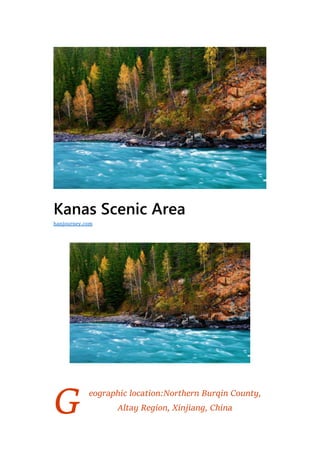
- 1. G Kanas Scenic Area eographic location:Northern Burqin County, Altay Region, Xinjiang, China hanjourney.com
- 2. Level:AAAAA Famous scenery:Moon Bay, Kanas Guanyutai, Wolong Bay Suitable for the play season:June and September Kanas Scenic Area is located in the middle section of the Altai Mountains in Xinjiang. It is located in the border of China with Kazakhstan, Russia and Mongolia. There are 55 scenic spots in the Kanas scenic area with a total area of 10030 square kilometers. There are 33 basic types, including Hanas National Nature Reserve, Kanas National Geological Park, Baihaba National Forest Park, Jia Dengyu. The National Forest Park, Kanas River Valley, Hemu River Valley, Naren Grassland, Hemu Grassland and Hemu Village, Baihaba Village, Kanas Village and other famous natural and scenic areas and three major cultural landscapes. The core essence of the Kanas National Scenic Area is the intense erosion of the glacier, and the ice stone surface is filled with the valley and forms the end of the ridge into a lake. The lake is 1375 meters above sea level. The lake is shaped like a crescent moon, with a length of 24.5 kilometers, an average width of 1.9 kilometers, an average water depth of 90 meters, a maximum depth of 188.4 meters, an area of 69,000 mu, and a water storage capacity of 4 billion cubic meters, one of the deepwater lakes in China. The main attractions of Kanas Scenic Area include Kanas Lake, Wolong Bay and Taijialin Corridor. On April 13, 2018, he was shortlisted for “Magic Northwest 100 Scenes”. Historical evolution In the 20th year of Emperor Qianlong of the Qing Dynasty (1755), the Quasi-German Department was settled. This area was under the
- 3. jurisdiction of the left general of Uriah Sutai. In the 27th year of the Qing Emperor Qianlong (1762), the Qing court compiled the Altai Wulianghai people living in the Yangtai of the Altai Mountains into seven flags, which were divided into left and right wings, and the chiefs of the wing were given a letter, which was attached to the left wing of the Altai Wulianghai. Zuoqi Zasak. In the twenty-ninth year of Guangxu Emperor Guangxu (1903), this place was under the jurisdiction of the Minister of the Court of Kobdo. In the thirty-second year of Guangxu (1906), Kobudo and Altai were divided. The place was under the jurisdiction of Altai. At this time, the area under the jurisdiction of the Minister of Altai was directly under the jurisdiction of the Qing court. In the first year of the Republic of China (1912), following the old system of the late Qing Dynasty, the Altai area was still under the jurisdiction of the central government. In the eight years of the Republic of China (1919), Altai was placed under the Xinjiang Provincial Government and set up Ashan Road. It is located in Burqin County, and the Kanas area is affiliated to Burqin County, Ashan Road, Xinjiang Province. After the founding of New China, in 1980, the People’s Government of Xinjiang Uygur Autonomous Region approved the establishment of the Kanas Nature Reserve. In 1986, with the approval of the State Council, it was identified as a national nature reserve, under the management of the Forestry Department of Xinjiang Uygur Autonomous Region, and set up a management office. In 2000, the Kanas Environment and Tourism Management Committee and the Kanas National Nature Reserve Administration were established. The organization is affiliated to Burqin County. In 2003, the Kanas administration moved to the Altay region and changed the Kanas Environment and Tourism Management Committee to the Kanas Environment and Tourism Administration to implement unified management of the development, utilization and protection of regional resources. In July 2006, the Altay Committee and the Administrative Office decided to set up the Kanas Scenic Area Committee and the Kanas Scenic Area Management Committee to clarify the large tourist jurisdiction of the Kanas Scenic Area of 10030 square kilometers and
- 4. the Hemu of Burqin County. The Hanek Mongolian Nationality Township and the Higahe Township of Habahe County are under the unified jurisdiction of the Scenic Area Management Committee. Geographical environment Location horizon The Kanas Scenic Area is located in the middle section of the Altai Mountains in Xinjiang. It is located in the area bordering Kazakhstan, Russia and Mongolia. The geographical coordinates of 10030 square kilometers are 48°30′20′′ north longitude and 87°07′37′′ east longitude.
- 5. Topography The Kanas Scenic Area is located in the vertical zone of the landform and vegetation of the Altai Mountains. It is from high to low. The altitude is more than 3,000 meters. It is a modern glaciers and permanent snow covered alpine ice and snow, and the altitude is 2400-3000 meters. The tundra mat-like meadow belt, 1300-2400 meters above sea level is the mid-mountain cold-temperature coniferous forest steppe belt (composed of coniferous species Siberian larch, Siberian fir, Siberian spruce, Siberian red pine), 800- 1500 meters above sea level for low mountains The hilly shrub meadow steppe belt, below 800 meters above sea level, is the oasis desert belt of the piedmont alluvial plain, with vertical vertical stratification, and the true appearance of 6-7 vertical natural landscape belts in the Altai Mountains. Climate Kanas Scenic Area is a cold temperate zone with a long cold period and a short frost-free period. It is located in the hinterland of Eurasia, far away from the ocean, with high latitude, wide disparity, and complex terrain, forming a unique climate. -0.2 ° C, extreme
- 6. maximum temperature of 29.3 ° C, minimum temperature of -37 ° C, the annual average temperature of 6 months is less than 0 ° C, the winter is up to 7 months. The coldest January average temperature is -16 °C, the hottest July average temperature is 15.9 °C, noon is only 20 °C, the frost-free period is 80-108 days, and the plant growth period is concentrated in May-August. The annual precipitation is about 1000 mm, and the maximum precipitation is 2100 meters above sea level. The winter is long and the snowfall is abundant. Generally, frost begins to appear in early August. At an altitude of 1400 meters above sea level, snowfall begins in late August; altitude is above 3,000 meters, snowfall begins in early August, until the end of May or early June of the next year, the snowfall period is about 8 months, and the snow depth can reach 1-2 meters, snowfall. The number of days is generally more than 73 days, and the stable snow cover period is about 200 days. The snow line is distributed at an altitude of 2,850 meters. The annual evaporation is about 1000 mm, which is roughly the same as the precipitation. The Kanas Nature Reserve has better water conditions, greater air humidity, and the relative humidity is generally 59-90%. The humidity increases with altitude, and the humidity in the forest generally reaches over 90%.
- 7. Main Attractions Review There are 55 large and small scenic spots in the Kanas Scenic Area, belonging to 33 basic types, including Hanas National Nature Reserve, Kanas National Geological Park, Baihaba National Forest Park, Jiadeng National Forest Park. The Kanas River Valley, Hemu River Valley, Naren Grassland, Hemu Grassland and Hemu Village, Baiha Ba Village, Kanas Village and other famous domestic and international landscape areas and three major cultural landscape areas. Kanas Lake Kanas Lake is the core essence of the Kanas National Nature Reserve. The glacier is strongly eroded, and the ice stone surface is filled with valleys, forming a lake with a final ridge. The lake is 1375 meters above sea level. The lake is shaped like a crescent moon, with a length of 24.5 kilometers, an average width of 1.9 kilometers, an average water depth of 90 meters, a maximum depth of 188.4 meters, an area of 69,000 mu, and a water storage capacity of 4 billion cubic meters, one of the deepwater lakes in China. The lake week is a green coniferous and broad-leaved mixed forest, which is connected with the vast mountain grassland.
- 8. Wolong Bay Wolong Bay is located 140 kilometers from the county town on the way to Burkan in Burqin County and 10 kilometers from Kanas. The lake is surrounded by dense forests, flowers and green grass, and the small islands in the lake are beautiful. The lake’s waters reach the middle of the stream, and the waves smash the boulders and the jade beads splash. There is a wooden bridge flying over the water outlet of the lake. Standing on the bridge to the north is a flat mirrored Wolong Bay to the south is the Kanas River roaring. About 1 km north of the Kanas River from Wolong Bay, you will see a blue crescent- shaped bay in the canyon, which is Moon Bay.
- 9. Bilberry Island On the island of Kanas Lake, there is a peninsula that stretches into the lake. The moss layer on the island is covered with a unique bilberry bush, which is called the island of bilberry. Taigalin Corridor The term taiga is originally from Russian and refers to the coniferous forest bordering the southern edge of the tundra near the polar. The term now refers broadly to the cold temperate boreal forest. In the cold temperate zone of the northern hemisphere, Taigalin is found throughout North America and northern Eurasia, forming a vast expanse of forests that make up the world’s largest forest ecosystem. The length of the Taijialin Corridor is 4.5 kilometers, which is rich in the essence of the Western Siberian Taigalin. The corridor is bordered by the sparkling Kanas Lake and the east is surrounded by winding mountains. The winding path is beautiful and can be seen. The Taijialin Marshes, the King of Taigalin, the Giant Root Carving Wall and many other attractions.
- 10. Fish station Guanyutai, a round-trip shuttle bus of 20 yuan/person, is a must-see for Kanas. It was built in 1987. It was called Guanyutai after the reconstruction. Why is it called Guanyutai? I think there are three reasons. First of all, the pavilion must be more than the bottom of the pavilion, and this reconstruction is the base is larger than the top pavilion, the platform is larger than the pavilion, of course, it should be called Taiwan. In addition, the pavilion has the suspicion of self- enclosure, and the Taiwan has the temperament of opening outwards, which is in line with the requirements of the times. Secondly, compared to the two words of the pavilion, the homonym is too particular. The ordinary people of the family, the pavilion is also stopped, and the Taiwanese are carrying, I spend money to travel, in order to seek happiness and auspiciousness, why should we stop and not lift it. No one wants to make progress in the Kanas tour and make a career. Once again, looking up at the fish platform in the mountain lake, it is like a incense stick that sits on the west hill. In the case of the sky with clouds or evening glow, the incense on the stage is steaming Xia Wei, full of eyes and clouds. These three are the reasons why the platform is better than the booth. The Observatory is the last exclamation point in the Kanas tour. Not looking at the fish platform is not enough to appreciate the beauty of the beautiful scenery of Kanas; it is not enough to understand the true meaning of life.
- 11. Safeguard The Kanas Scenic Area was included in the key area of the 2008 Altay region cultural relics survey. In the third national cultural relics survey in 2011, more than 130 new cultural relics were discovered, including the Kanas scenic spot in the national 5A scenic spot. Newly discovered 6 ancient tombs dating from 2000 to 3000 years ago. The census and protection of cultural relics in the Altay region began in 1988. In the past 20 years, more than 200 cultural relics have been discovered and identified. Among them, there are 2 state-level cultural relics protection units and 15 autonomous region-level cultural relics protection units. There are 46 municipal cultural relics protection units. The geological relics of the Kanas National Geological Park in Xinjiang are characterized by Quaternary glacial relics. Among them, Kanas Lake is the deepest ice-blocking lake in China. The park has rich and typical glacial relics, and its preservation system is complete. It is one of the rare middle-altitude areas in the world where the Quaternary glaciers are well preserved. The most typical area of Quaternary glacial remnants in the same latitudes of the world.
- 12. Honors Kanas Scenic Area has “one of the five most beautiful lakes in China”, “one of the six most beautiful ancient villages in China”, “the top of China’s top ten autumn landscapes”, and “China Photographers Association Creation Base”, which has become a tourist in Xinjiang. Faucet. Kanas is a national AAAAA-level tourist scenic spot with National Geological Park, National Nature Reserve, Jiadeng National Forest Park and Baihaba National Forest Park. Since 2000, Kanas Scenic Area has won the national 5A level scenic spot, National Geological Park, National Forest Park, China’s top ten scenic spots in the west, Chinese photographers’ creation base, China’s most beautiful top ten lakes, China’s most beautiful top ten autumn colors, Chinese people Dozens of honors and brands, such as members of the Biosphere Network and demonstration sites of national civilized scenic spots, and the first batch of “China National Natural Heritage, National Natural and Cultural Heritage List”. On April 13, 2018, he was shortlisted for “Magic Northwest 100 Scenes”.
- 13. Traffic information and ticket prices Walking route: Kanas Lake to Guanyu Pavilion, Wolong Bay, Baiha Ba Village, Naren Grassland. By plane: After the completion of Kanas Airport, Urumqi will take you directly to the scenic spot by plane. By car line: Urumqi-Kelamayi Oil City-Devil City-Huyanglin-Fuhai Fishing Ground-Fuhai County-Beach Bathing-Bingtuan City Beibei-Buljin County-Colorful Beach-Kanas Urumqi – Cainan Oilfield – Huoshan – Junggar Basin – Wulunguhe – Fuhai Beach – Altay City Hualin Park – Chemuerchek Ancient Tombs – Burqin County – Colorful Beach – Habahe County – Baihaba Village – Northwestern First Sentinel – Kanas Lake Urumqi-Kelamayi Oilfield-Devil City-Huyanglin-Burqin County- Colorful Beach-Hailiutan-Agungatei Grassland Stone Man-Jadengyu- Kanas Lake ticket price: The ticket price of Kanas scenic spot is 160 yuan/person·2 days in the peak season and 80 yuan/person·2 days in the off-season. The peak season is from May 1st to October 15th, and the off-season is from October 16th to April 30th.