Anqing Tianzhu Mountain Scenic Area - AAAAA Rated Natural Beauty
•
0 gostou•54 visualizações

Tianzhu Mountain Scenic Area is located in Anqing City, Anhui Province. It contains many natural attractions like Tianzhu Peak (1488m), Feilai Peak, Tianchi Peak, Mysterious Valley, and Penglai Island. Cultural sites include Sanzu Temple, an important center of Zen Buddhism. The scenic area has a humid subtropical climate with abundant rainfall and forests. It was designated a national scenic area in 1982 and contains diverse plant and animal life across its 333 square km protected area.

Recomendados
Mais conteúdo relacionado
Mais procurados
Mais procurados (13)
Semelhante a Anqing Tianzhu Mountain Scenic Area - AAAAA Rated Natural Beauty
Semelhante a Anqing Tianzhu Mountain Scenic Area - AAAAA Rated Natural Beauty (20)
Mais de Journey Han
Mais de Journey Han (20)
Último
Último (20)
Anqing Tianzhu Mountain Scenic Area - AAAAA Rated Natural Beauty
- 1. Anqing Tianzhu Mountain Scenic Area hanjourney.com
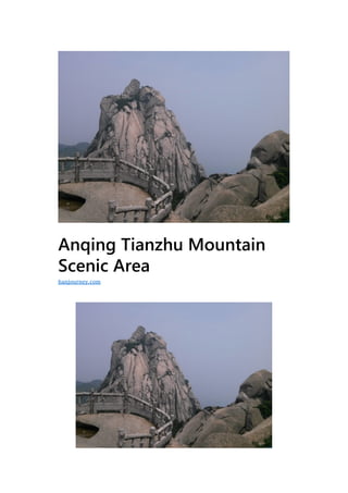
- 2. G eographic location:West of Qianshan County Level:AAAAA Main Attractions:Tianzhu Peak, Feilai Peak Climate:Subtropical monsoon humid climate Tianzhu Mountain Scenic Area is located in the west of Qianshan City, Anqing City, Anhui Province. The scenic spot is named after the main peak such as “Qingtian Yizhu”. It is known as “the first mountain of Jianghuai” and mainly has Tianzhu Peak and Feilai Peak. Tianchi Peak has 45 peaks above the kilometer, with the main peak at an elevation of 1488.4 meters, the planned protected area of the scenic spot with an area of 333 square kilometers, and the scenic area with an area of 82.46 square kilometers. Tianzhu Mountain Scenic Area is surrounded by natural landscapes such as Mingya, Kistler, Yidong, Qi Waterfall and Yunhai. It is one of the three famous mountains in Anhui Province (Huangshan, Jiuhuashan and Tianzhushan). The religious and cultural heritage of the scenic spot is profound and it is one of the birthplaces of Zen Buddhism in China. The third generation of Zen ancestors was stationed in the Xi Dynasty and passed on the cloak. The Sanzu Temple has been repeatedly sealed by the emperors of the past, and enjoys the reputation of “Who is the first in the Zen Forest, and the South Crown in this place”. Preserved precious cultural relics such as “Unbinding Stone”, Sanzu Stupa, and Sanzu Cave. In 1982, it was approved by the State Council as the first batch of national key scenic spots. In 1992, it was approved as a national forest park. In 2000, it was awarded the National AAAAA Grade Scenic Spot, and in 2011, it was approved as the World Geopark.
- 3. Development History Tianzhushan had no special management institutions before the Republic of China. The development and construction was limited to the temple viewing pavilion, and the tourists were mostly presided over by the temple. In the 31st year of the Republic of China (1942), the Inspector of the Anqing Administrative Office, Fan Yuansheng, advocated the establishment of the “Tianzhushan Development Committee” and received funding from the Anhui Provincial Government and social fundraising, raising a total of nearly one million yuan (French currency). Due to various reasons such as social unrest at that time, only Yueyun Mountain Pavilion, Cuiyun Villa and a simple hiking trail (Liangpengping to Tianzhu Peak) were built. In 1958, the establishment of the Tianzhushan Forest Farm created a large number of plantations. Among them, Beiguanzhai has 8,000 mu of bamboo sea, and the Tongluo tip has thousands of acres of cedar forest. Liangyaping and Nanguanzhai have large patches of pine. In 1982, with the approval of the State Council, Tianzhu Mountain was identified as the first batch of national key scenic spots. In November of the same year, the Tianzhushan Garden Management Office was established. In 1986, it was changed to the Tianzhushan Management Office of Anhui Province. It has six units including Tourism, Garden, Infrastructure, and Finance. The state has invested a total of 2.58 million yuan, built 7 large and small hydropower stations, 37 kilometers of highways, 4 times a day, and 39 scenic trails in the scenic area, counting 133 kilometers. Built 26 hotels and restaurants to operate Beijing, Yang, Sichuan and Anhui cuisine. From 1979 to 1987, Meicheng, Sanzu Temple, Chazhuang, Mazu, Qinglongyu, etc. have been established as centers for economic, cultural, administrative, Buddhist and tourist activities. By the end of the 20th century, Tianzhushan National Scenic Area covers an area of 82.46 square kilometers. It has successively built eight scenic spots such as Hutou Cliff, Jiujing River, Sanzu Temple and Longtan River, and a teahouse center reception station. Named attractions include 46 Peak, 17 Ridge, 7 Gang, 18 Cliff, 14 Rock, 7 Guan, 22 Cave, 4 Chong, 6 Source, 17 Spring, 8 Waterfall, 1 Sichuan, 3 Stream, 5涧, 13 River 3, 16
- 4. wells, 6 pools, 3 lakes, etc. In 2010, the “Overview of the Tianzhu Mountain Scenic Area” was approved by the State Council. The plan defines the scenic area as 102.72 square kilometers, and the core scenic area is defined as 12.8 square kilometers. The planned control scope extends to the outer protective belt area. It is 201.3 square kilometers. In April 2016, the scenic spot began to implement the “three major projects” of road smoothing, quality improvement and resource protection projects. Geographical environment Location horizon Tianzhu Mountain Scenic Area is located in the western part of Qianshan City, Anqing City. It is located in the eastern section of the Dabie Orogenic Belt of the Central Apostolic System in China. The center is about 30°44′12.99′′ north longitude 116°27′18.84′′ east, which is one of the east extension of the Dabie Mountain Range. Component (or the remaining pulse). The main peak is 1488.4 meters above sea level, the planned protected area is 333 square kilometers, and the scenic area is 82.46 square kilometers.
- 5. Topography Tianzhu Mountain is the key part of the Paleozoic North China plate and the Yangtze plate, which is converging, submerging and splicing. The Mesozoic land-continent collisional orogeny and its composite part with the Tanlu fault zone. The geological relics are relatively systematic and complete, mainly with the deepest excavation and ultra-high pressure minerals. A classic section of the Dabie Mountain UHP metamorphic belt, rich in rock and rock.
- 6. Zhongshan Zhongshan is located in the hinterland of Tianzhu Mountain. It is composed of mixed granite, with multiple canyons divided, and the main peak Tianzhu Peak cliff environment. They are more than 1000 meters above sea level, more than 600 meters high, and the highest is Tianzhu Peak, with an altitude of 1488.4 meters. The mixed granites that make up Zhongshan are particularly developed in horizontal, vertical and oblique joints, and the group and density are varied. In the top and the mountainside, the water and the solid state change frequently in the joints, so that the rock mass is continuously broken and disintegrated, and various stone elephants are formed. Low mountain The low mountains are located between 500 and 1000 meters above sea level, ranging from 400 to 600 meters. The low mountains adjacent to Zhongshan are composed of mixed granite. The low mountains that are connected to the hills in the Hejiatun and Wusong areas in the south are composed of two gneiss. The peaks of Shilong, Tianshu, Jiangdan and Tianma are the same as those of Zhongshan, and they are steep slopes. There is also a distribution of stone statues in this area. Pig head stone, mixed yuan carp, wooden fish stone, ship
- 7. stone and so on. Yujing Mountain and Jiawu Mountain are mainly composed of two long gneiss and black mica slant gneiss. The mountain is relatively moderate, and the height is also small. Generally, the ridge is wider and the slope is less than 15°. The hillside is not as steep as the above low mountains. Mostly the slope is below 20°. Hills The hills are distributed in strips. Including the local areas of Shuangfeng, Yuantan, Lingtou, Yujing, Panpu and other townships. The altitude is 100 to 400 meters. The relative height difference is 50 to 300 meters. The top of the mountain is mostly a garden type. The slope is generally 10° to 30°. The hills are smooth and the top is comfortable. The gully is developed significantly, and the valley is “U” shaped. The exposed rock formations are gneiss, mixed granite and a small amount of neutral rock. The soil parent material is acidic, neutral crystalline rock and a small amount of carbonate rock slope. The denudation and accumulation of the area are parallel and the relative humidity is large.
- 8. Valley The basins scattered throughout the Tianzhu Mountain are small in scale. The Longtan River Valley is an erosion structure that is intermittent and distributed along the Longtan River. The widest point is only about 500 meters, and it consists of gravel and sand layers. The basins in Zhongshan are roughly distributed in the heights of 400-500 meters, 800 meters and 900-1000 meters. Such as the tea village basin (400 ~ 500 meters). The Mazuyan Basin (750-800 m) and the Serpentine Basin (900-1000 m).
- 9. Stream Tianzhu Mountain is a long-term uplift area, and the entire stream is radially characterized. The rivers are all raised from the center of the Tianzhu Peak, Feilai Peak, Yingzheng Peak, and Tianshi Peak. They are poured into the surrounding area and flow into the diving and the Weihe River. The streams of Tianzhu Mountain belong to the first and second tributaries of the diving and the Weihe River. Its development is strictly controlled by fault structure and vertical joints. The cross section of the valley is characterized by deep valleys and valleys in the valley. Climatic characteristics Tianzhu Mountain is located in the northern edge of the central subtropical zone. The humid airflow along the river is blocked by the Dabie Mountains. It meets the cold air over the mountainous area and directly affects the climate change of Tianzhu Mountain. Its average annual rainfall is above 1900 mm, and the annual cloud is 180 days. It is 235 days, the annual average temperature is 9.5 °C, the average temperature in July is 20 °C, and the average temperature in January is -2 °C.
- 10. Hydrological characteristics The streams that are radially distributed in the scenic spots are merged into the diving and drowning water under the Tianzhu Mountain, forming a pattern of “two waters and one mountain”. Both waters are mountain rivers, showing a steep rise and fall. The total length of the dive is about 116 kilometers, and the length of the park is 24.7 kilometers. The highest water level in the calendar year is 31.82 meters, the lowest water level is 28.1 meters, and the precipitation in normal years is 1.16 billion cubic meters. The total length of the drowning is about 120 kilometers, the length of the park is 32 kilometers, and the precipitation in normal years is 991 million cubic meters.
- 11. Natural resources Vegetation resources As of 2015, there are more than 2,000 ancient trees in the Tianzhu Mountain Scenic Spot in Tianzhu Mountain, including more than 50 trees over the millennium, more than 200 trees from 500 to 1000, and the rest between 100 and 500 years. . Its tree species include the national first-class protection plant ancient ginkgo, the national second-class protection plant toad, maple, bitter buckwheat, Feng Yang and so on. The plants that have been managed include 1,638 species of 214 families and 146 genera, and 119 families of trees, shrubs and herbaceous plants, including 300 species of seed plants. Animal resources As of 2014, there are tigers, leopards, small civet cats, dog scorpions, and porcupines in the Tianzhu Mountain Scenic Area. Birds have long- tailed pheasants, black magpies, thrushes, etc. There are also various kinds of fish in the water, such as baby fish (Dayu).
- 12. Main Attractions Natural landscape Tianzhufeng Tianzhu Peak, also known as the bamboo shoot tip, is 1488.4 meters above sea level and is the highest peak in the Jianghuai area. Anhui Tianzhu Mountain is also known as Lushan, and Anhui Province is referred to as “皖”. Tianzhu Mountain is located in the north bank of the Yangtze River and in Qianshan City of Anhui Province. Its main peak stands tall, such as the giant pillar qingtian, hence the name Tianzhu Peak, and the mountain is named after it.
- 13. First-line day Under the Tianzhu Peak, there is a peak with a crack in the main peak, commonly known as Xiaotianmen, also known as “a line of heaven.” The peak height is only 10 meters, such as an early flower, so the peak name is “Flower Peak”. On the stone wall of Tianzhu Peak, there is a four-character “Shoutiandi”. For the nine years of the Republic of China, the Kuomintang general Liu Yichun wrote inscriptions. Duxian Bridge Tianchi Peak is the second peak of Tianzhu Mountain. It is slightly higher than Feilai Peak and has an elevation of 1,426 meters. Tianchi Peak, a split of three, is connected by two sections of stone, called “Duxian Bridge”, and climbs to the top of Tianchi Lake, where you can see the sunrise, the sea of clouds, the Buddha’s light and the evening glow. Across the transitional Xianqiao, that is, a platform with a square of less than 10 square meters, two stone pits of Taichung size, called “Tianchi”. The outer edge of the Tianchi platform is a cliff cliff, called the test heart cliff. Try the heart of the cliff to see the “Tianzhushan Buddha Light” landscape.
- 14. Mysterious valley Mysterious Valley, in the south of Tianchi Peak, also known as Si Yuan (Xuan) Cave. The mysterious valley stone consists of the Dragon Palace, the labyrinth, the Xiaoyao Palace, etc., from the entrance of Longyan Huxiao Cliff, passing through the Wuzhi Peak, close to the Feilai Peak, surrounded by the Everest, directly to the Duxian Bridge, with a total length of more than 400 meters and a drop of more than 100 meters. . There are holes in the cave, there are holes in the cave, some are connected, some are separated, the Taoist sees this place as a heaven and a blessing, and the Taoist book is called the fourteenth hole. The old nicknamed this hole “the air can be filled with tens of thousands of martial arts, with crystal rock under it, straight to the Bohai Sea. Later called the chief officer hole.”
- 15. Penglai Island Penglai Island is located on the left side of Huafeng, Penglai Peak is 1350 meters above sea level, Tianchi Peak in the south and Tianzhu Peak in the north. Penglai Peak is a single stone wall, with steep walls cut off on the west, south and north sides. It extends over 100 meters to the west. The peak is long and narrow, with a length of more than 100 meters and a width of only two or three meters. Stone grades and guardrails have been built today. In the Ming Dynasty, Li Geng had a poem: “There is still not half a mile, and it is already in Penglai.” The summit of the mountain can be seen from Yingshan, Hubei, Huoshan and Jinzhai in Anhui. Jiujing River The Jiujing River originated from the back palace of Tianzhu Mountain. It has been twisted and stretched for more than ten kilometers. It is one of the ten scenic spots of Qianyang. In the year- round, Jiujing Xifeng has a northwesterly wind blowing into the ancient mouth and the wild village regardless of the yin, sunny, rain and snow. Therefore, Taniguchi and Yezhai are also summer resorts.
- 16. Alchemy Lake Alchemy Lake, with a water surface area of nearly 30,000 square meters, a water storage capacity of 80,000 cubic meters, and an altitude of 1,100 meters above sea level. Under the calm water surface of “Alchemy Lake”, it was called “Good Medicine Ping” before it was repaired. Shanglian Dan.” Han Weiming said that Zuo Ci had used this medicine to make alchemy, which was named “Alchemy Lake”. Left is the “Alchemy Room” and “Alchemy Terrace”. In the “Alchemy Terrace”, the lion peak is on the left, the Qinglong back is on the right, and the Dengxian drums are in the east. The horns, the basins, and the welcoming peaks lie south.
- 17. Tianzhu Qingxue Tianzhu Qingxue, commonly known as “June Snow”. “Tianzhu Qingxue” is located on the hillside in the north of Qinglongtun, Tianzhu Mountain. Li Yu, a poet of the Ming Dynasty, praised the poem: “In May and June, the cold often lived, and the millennium of snow could not be lost.” The cause of Tianzhu Qingxue is related to the geological and geomorphological forms here. “Snow Mountain” consists of feldspar which is mainly composed of mixed granite with relatively low quartz content. The rock is often wet, the sun is cold at night, the rock layer gradually becomes weathered and peeled off, and gradually becomes loose and sand, which accumulates over time and accumulates into posts. Flying peak Feilaifeng is at the western end of the “Longyan Huxiaoya”. It is 1424 meters above sea level. The whole mountain is composed of a whole boulder. The top has a stone length of about 3 feet, and the circumference is more than 30 feet. Gaozhangyu, stone Called “Flying Stone”, the peak is due to the stone name. On the stone wall in the west of Feilai Peak, due to the long-term erosion of the spring water, a patch of stone scales resembling the “dragon scale” is formed.
- 18. Baoyuefeng To the south of Feilai Peak is the “Baoyue Peak”. There are two tentacles in the top of the mountain, and a flat square-shaped slate in the middle. Two pieces of clever stone are slightly tilted backwards. The east side, the sky frog peak, the Dansha peak, the flying tiger peak, the Buddha peak, Yingzheng Peak, Shinu Peak, Linjiao Peak, Raspian Peak, Tianshi Peak, etc.
- 19. Tianzhusong A tall pine tree stands between the cliffs on the side of Tianchi Peak. This Tianzhu is long on a stone wall with a height of 1,000 meters. The stone wall faces the Tianzhu Peak and the Feilai Peak. Tianzhu Song is long on the cliff. The height is only 5 meters, but it is only 80 centimeters thick. It can be surveyed for more than 1,500 years. History. Ma Zuyu The main attractions of Mazuyu are Mazu Temple, Foguang Temple, Lanshi, Bajie Nianjing, Tianshu Peak, Tianfeng Peak, and Pigou Stone. The fragrant sons, screens, and stone dragons are arranged in front, and the Tianmen, Tianma, and Dandan peaks are listed. In front of Mazu Temple, there was Mazu Cave, which was passed down to the Mazu Dao. The stone on the right side of the cave was like a pillar. On the other hand, the Kuomintang Sichuan warlord Yang Sen inscribed the words “South Tianyizhu”. Then right is the Lotus Cave (also known as Danfang), which is the place where Han Weifang Shi Zuo Ci Lian Dan. There is a big stone next to it, called “Lei Shishi.” The Qing Dynasty Li Yunhuang engraved the word “mixed yuan Xiawu”. To the south of Mazuyu is the snow waterfall cliff. Foguang Temple was once
- 20. a cave of Xijing, a Zen master in the Tang Dynasty. During the Five Dynasties, the local mountain people built the land on the ground, and the world was called Mazu. Cultural attractions Stone carving culture Tianzhu Mountain ranges from Shi Niu Gu Cave to Mazu Temple, from Hutou Cliff to Tianzhu Temple. From the Jiujing River to Nantianmen, there are inscriptions from the ancient sages, including the valley springs in the Shi Ni Gu Cave. Stone carvings have been listed as national key cultural relics protection units by the State Council for a long time. On the stone wall of about 300 meters long, there are more than 300 stone carvings in Tang, Song, Yuan, Ming, Qing, Republic of China and modern times. The poems, words, texts, pictures and forms of the poems are different. There are all kinds of things, including the original works of Wang Anshi and Huang Tingjian.
- 21. Religious culture Tianzhu Mountain has two religious cultures. Taoism listed this as the 14th Heaven of the famous mountain in China, and called it the town of the five major towns. Since the Eastern Han dynasty Zuo Ci was preaching here, Taoism has taken root here. During the Xiaoliang period, Jinling Gaochun Baozhi came to this sermon. At this point, Tianzhu Mountain became a holy place for Buddhism and Taoism. During the Tang and Song Dynasties, there were no more than a hundred temples. The representative buildings of Buddhism are the Sanzu Temple and the Buddha Temple and the Taiping Tower. Sanzu Temple was listed by the State Council as one of the 142 key temples of the Han nationality in 1982. It was originally named “Valley Temple” by Emperor Wu of the Liang Dynasty. Later, the three ancestors of the Zen Buddhism were stationed here in Xi, hence the name “Sanzu Temple”.
- 22. Historical culture The historical site of the scenic spot has a “Xuejiagang Cultural Site” 5,000 years ago. Xuejiagang Cultural Relics is located in Wanghe Town, Qianshan County. It has a total area of more than 2,000 square meters and more than 2,000 unearthed cultural relics. There are three kinds of unearthed cultural relics: stoneware, pottery and jade. The production tools are mainly stone tools, and the living utensils are mainly pottery. These artifacts are mainly Neolithic objects, and there are a small number of Shang Dynasty and Tang and Song dynasties. Celebrity culture The celebrity trails of Tianzhu Mountain can be traced back to the Han Dynasty Emperor Fengyue, and there are relics such as “Yueyuetai” and “Yujiaqiao” that are preserved by the Hanwu Festival. There are astronomers and mathematicians Wang Fan in the Three Kingdoms Period. Late Tang poet Cao Song, Tang Dynasty poet Li Bai, Northern Song Dynasty writer Wang Anshi, Huang Tingjian,
- 23. Song Dynasty prime minister Wang Wei, painter Li Gonglin, modern Beijing opera ancestor Cheng Changgeng, Zhang Hui novel Zhang Henshui, acrobatic queen Xia chrysanthemum and other celebrities visited Tianzhushan. Military history The location of Tianzhu Mountain has always been a battleground for the military. At the end of the Southern Song Dynasty, Liu Yuan, the righteous soldier, settled in the West Gate, defeating the Yuan army many times and persisting in fighting for 18 years. The general of the Taiping Army, Chen Yucheng, led the department in the Tianzhu Mountain area and held the Qingbing for many years. During the War of Resistance Against Japan and the War of Liberation, the guerrillas led by the Communist Party were active in Tianzhu Mountain.
- 24. Festival event In 2012, the first Tianzhu Mountain Folk Customs Tourism Food Culture Festival was held. In 2013, the “Tianzhushan Cup” 2013 Anhui First College Student Cultural Tourism Festival was held. In the same year, Tianzhu Mountain Scenic Area launched folk culture activities such as wrapping scorpions, stone carvings, and Xu Xinyuan. In 2014, Tianzhu Mountain Scenic Area launched the first stop of the “Chinese Calligraphy and Painting Famous High-speed Rail Miles”. In 2016, Tianzhu Mountain Scenic Area held 20 tourism activities. Honors In 1982, it was approved by the State Council as the first batch of national key scenic spots. 1992 Approved as National Forest Park Approved as a national 4A tourist area in 2000 Approved as National Geopark in 2005 Listed in the China Natural and Cultural Heritage List in 2009 In 2011, it was approved as a national 5A-level tourist area and a
- 25. national science education base. 2011 Approved as the World Geopark In 2011, it was approved as a land resource science base. January 2015 Listed in the China World Heritage Recommendation List Safeguard Cultural relic protection In 2009, the Tianzhu Mountain Scenic Spot in Anqing promoted the Valley Flow Spring Cliff Stone Inscription Protection Project, which was the 861 key project of Anhui Province. The first phase of the project completed the reinforcement of the existing stone rock mass, depicting red and rubbing protection. The second phase of the project redesigned the entrance and the tour line of the entire scenic spot of the valley flow spring. In 2015, in order to protect the historical sites such as “Yueyuetai” and “Yujiaqiao” that were preserved in the Hanwu Festival in the scenic area, the Qianshan County Government strictly abides by the Regulations on the Protection of Geological Relics and edits the Tianzhushan World. “Geopark Planning”, compiled the “Peozoic Mammal Group Fossil Origin Protection Plan of Tianzhushan
- 26. Geopark”, and divided the park into special, primary, secondary and tertiary protection zones according to the plan. And according to the level, nature and geographical environment of the historic building, the necessary protection scope is established and signs are established. Cultural relics buildings shall not be dismantled, moved, rebuilt or built at will. Any changes to the cultural relics construction shall be submitted to the corresponding cultural relics authorities for approval. Visitors are strictly forbidden to touch the stone inscriptions and inscriptions, and to protect the important stone carvings and inscriptions, such as protective railings and tablet pavilions. Resource protection In the scenic area and its surrounding areas, there are a large number of ancient and famous trees. In 2016, in order to ensure that ancient and famous trees are not damaged, on the basis of census registration, establishment of archives and listing protection, they also regularly conduct on-the-spot investigations, soil conservation, slope protection, Construction of fences, regular pest and disease control, to achieve responsibility to people.
- 27. Travel Information Ticket Big ticket: 130 yuan / person. The scenic spot tickets are subject to the peak season ticket sales policy from March 16th to November 15th. Preferential policies: teachers, students, active military personnel, senior citizens over 60 years old, and disabled persons can enjoy the half-ticket preferential policy with valid certificates. Older people over 70 can enjoy the free ticket discount with the old age certificate. Opening hours Spring, summer and autumn seasons: 06:30–17:00; Winter: 07:00 –16:00 Traffic Qianshan City is 23 kilometers away from Tianzhu Mountain Scenic Area. From the entrance of Tianzhu Road in the urban area (locally known as Zero Monument) or Tianzhushan Paifangmen Station, you can take the bus from Qianshan to Tianzhu Mountain to the scenic spot. 15 yuan per person.
- 28. The BUS of the Qianshan Bus Station West Station runs to the main scenic spot of Tianzhu Mountain every 5 minutes.