SlideShare uma empresa Scribd logo
1 de 10
Baixar para ler offline
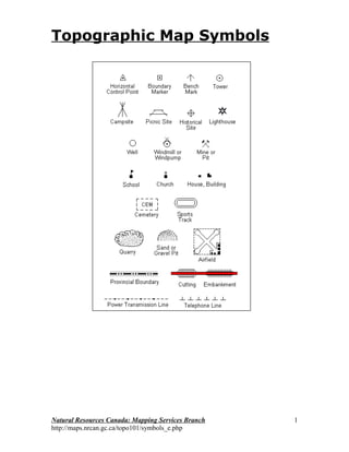
Topographic Map Symbols


Natural Resources Canada: Mapping Services Branch   1
http://maps.nrcan.gc.ca/topo101/symbols_e.php
Natural Resources Canada: Mapping Services Branch   2
http://maps.nrcan.gc.ca/topo101/symbols_e.php
Topographic Map Symbols - Roads and Trails

                         Feature Name                            Symbol
                   Road - hard surface, all season-4 Lanes
                                    (two way road, divided)
                   Road - hard surface, all season- 2 Lanes

                                         Less than 2 Lanes
      Road - loose or stabilized surface, all season-2 Lanes
                                          Less than 2 Lanes

                         Road - loose surface, dry weather

                                   Rapid transit route, road

                                  Road under construction
                  (width and colour vary with classification)

                                Vehicle track or winter road

                                            Trail or portage

                                                Traffic circle

                                     Highway route number


Natural Resources Canada: Mapping Services Branch                         3
http://maps.nrcan.gc.ca/topo101/symbols_e.php
Topographic Map Symbols - Railways and Airports
                        Feature Name                  Symbol

                         Railway - multiple track

                           Railway - single track

                                 Railway sidings

                           Railway - rapid transit

                    Railway - under construction

                            Railway - abandoned

                                 Railway on road

                                  Railway station

                                 Airfield; Heliport

                    Airfield, position approximate

                Airfield runways; paved, unpaved


Natural Resources Canada: Mapping Services Branch              4
http://maps.nrcan.gc.ca/topo101/symbols_e.php
Topographic Map Symbols - Other Transportation Features
                            Feature Name                  Symbol

                          Tunnel; railway, road

                                          Bridge

                        Bridge; swing, draw, lift

                                     Footbridge

                                      Causeway

                                            Ford

                                             Cut

                                   Embankment

                                     Snow shed

                                 Barrier or gate


               Topographic Map Symbols - Recreation
                          (Feature Name                            Symbol

                                                Sports track

                                             Swimming pool

                                                    Stadium

                                                 Golf course

                                          Golf driving range

                                  Campground; Picnic site

                                          Ski area, ski jump

                                      Rifle range with butts

          Historic site or point of interest; Navigation light

                                    Aerial cableway, ski lift


Natural Resources Canada: Mapping Services Branch                           5
http://maps.nrcan.gc.ca/topo101/symbols_e.php
Topographic Map Symbols - Agriculture and Industry
                          Feature Name                            Symbol

                                                          Silo

                                                     Elevator

                                                 Greenhouse

                                Wind-operated device; Mine

         Landmark object (with height); tower, chimney, etc.

                                    Oil or natural gas facility


                   Pipeline, multiple pipelines, control valve

                                      Pipeline, underground
                            multiple pipelines, underground

                                              Electric facility

                                    Power transmission line
                                              multiple lines

                                              Telephone line

                                                       Fence

                              Crane, vertical and horizontal

                                               Dyke or levee

                                                    Firebreak

                                                      Cut line


Natural Resources Canada: Mapping Services Branch                          6
http://maps.nrcan.gc.ca/topo101/symbols_e.php
Topographic Map Symbols - Buildings
                           Feature Name                         Symbol

                        School; Fire station; Police station

           Church; Non-Christian place of worship; Shrine

                                                   Building

                                            Service centre

                                             Customs post

                                      Coast Guard station

                                                 Cemetary

                                                     Ruins

                                                       Fort


                 Topographic Map Symbols - Elevation
                           Feature Name                          Symbol

          Horizontal control point; Bench mark with elevation

                                           Precise elevation


                               Contours; index, intermediate


                                        Depression contours


Natural Resources Canada: Mapping Services Branch                         7
http://maps.nrcan.gc.ca/topo101/symbols_e.php
Topographic Map Symbols - Geology and Geomorphology
                        Feature Name         Symbol

                      Cliff or escarpment

                                   Esker

                                   Pingo

                                   Sand

                                Moraine


                                  Quarry


                                   Cave


              Topographic Map Symbols - Land Cover
                        Feature Name        Symbol


                         Wooded area


                              Orchard


                              Vineyard


Natural Resources Canada: Mapping Services Branch        8
http://maps.nrcan.gc.ca/topo101/symbols_e.php
Topographic Map Symbols - Hydrographic Features (Man Made)
                       Feature Name                   Symbol

                                              Lock

                                Dam; large, small

                               Dam carrying road

                                       Footbridge


                                      Ferry Route


                             Pier; Wharf; Seawall

                                       Breakwater

                        Slip; Boat ramp; Drydock

                     Canal; navigable or irrigation

                               Canal, abandoned

                             Shipwreak, exposed

                    Crib or abandoned bridge pier

                                 Submarine cable


              Seaplane anchorage; Seaplane base


Natural Resources Canada: Mapping Services Branch              9
http://maps.nrcan.gc.ca/topo101/symbols_e.php
Topographic Map Symbols - Hydrographic Features (Naturally
                       Occurring)
                        Feature Name                Symbol

                                            Falls

                                         Rapids

                          Direction of flow arrow

                                    Dry river bed

                            Stream - intermittent

                Sand in Water or Foreshore Flats

                               Rocky ledge, reef

                                   Flooded area

                                 Marsh, muskeg

                                         Swamp

                     Well, water or brine; Spring

                  Rocks in water or small islands

                                 Water elevation


Natural Resources Canada: Mapping Services Branch            10
http://maps.nrcan.gc.ca/topo101/symbols_e.php

Mais conteúdo relacionado

Mais procurados

Topographic maps presentation_mine
Topographic maps presentation_mineTopographic maps presentation_mine
Topographic maps presentation_minemisterbatroms
 
Projections and coordinate system
Projections and coordinate systemProjections and coordinate system
Projections and coordinate systemMohsin Siddique
 
Remote Sensing Platforms and Sensors
Remote Sensing Platforms and SensorsRemote Sensing Platforms and Sensors
Remote Sensing Platforms and SensorsUday kumar Devalla
 
6. lecture 5 cadastral maps
6. lecture 5 cadastral maps6. lecture 5 cadastral maps
6. lecture 5 cadastral mapsFenTaHun6
 
Landslide Susceptibility Map using Remote Sensing and GIS
Landslide Susceptibility Map using Remote Sensing and GISLandslide Susceptibility Map using Remote Sensing and GIS
Landslide Susceptibility Map using Remote Sensing and GISAtif248367
 
Data models in geographical information system(GIS)
Data models in geographical information system(GIS)Data models in geographical information system(GIS)
Data models in geographical information system(GIS)Pramoda Raj
 
QUERY AND NETWORK ANALYSIS IN GIS
QUERY AND NETWORK ANALYSIS IN GISQUERY AND NETWORK ANALYSIS IN GIS
QUERY AND NETWORK ANALYSIS IN GISDEVANG KAPADIA
 
Numbering system of topographical map
Numbering system of topographical mapNumbering system of topographical map
Numbering system of topographical mapMithun Ray
 
1 2 aerial photography
1 2 aerial photography1 2 aerial photography
1 2 aerial photographymayasubodh22
 
Geomorphology Topic 1 (Part 1) - Basic Concepts
Geomorphology Topic 1 (Part 1) - Basic ConceptsGeomorphology Topic 1 (Part 1) - Basic Concepts
Geomorphology Topic 1 (Part 1) - Basic ConceptsWilliam W. Little
 

Mais procurados (20)

Digital terrain model
Digital terrain modelDigital terrain model
Digital terrain model
 
Spot satellite
Spot satelliteSpot satellite
Spot satellite
 
Topographic maps presentation_mine
Topographic maps presentation_mineTopographic maps presentation_mine
Topographic maps presentation_mine
 
Digitalcartography
DigitalcartographyDigitalcartography
Digitalcartography
 
Rivers Revision
Rivers RevisionRivers Revision
Rivers Revision
 
Projections and coordinate system
Projections and coordinate systemProjections and coordinate system
Projections and coordinate system
 
Topographic Maps Notes
Topographic Maps NotesTopographic Maps Notes
Topographic Maps Notes
 
geomorphology of ganga basin
geomorphology of ganga basingeomorphology of ganga basin
geomorphology of ganga basin
 
Remote Sensing Platforms and Sensors
Remote Sensing Platforms and SensorsRemote Sensing Platforms and Sensors
Remote Sensing Platforms and Sensors
 
6. lecture 5 cadastral maps
6. lecture 5 cadastral maps6. lecture 5 cadastral maps
6. lecture 5 cadastral maps
 
Landslide Susceptibility Map using Remote Sensing and GIS
Landslide Susceptibility Map using Remote Sensing and GISLandslide Susceptibility Map using Remote Sensing and GIS
Landslide Susceptibility Map using Remote Sensing and GIS
 
Data models in geographical information system(GIS)
Data models in geographical information system(GIS)Data models in geographical information system(GIS)
Data models in geographical information system(GIS)
 
QUERY AND NETWORK ANALYSIS IN GIS
QUERY AND NETWORK ANALYSIS IN GISQUERY AND NETWORK ANALYSIS IN GIS
QUERY AND NETWORK ANALYSIS IN GIS
 
Map projections
Map projectionsMap projections
Map projections
 
functions of GIS
functions of GISfunctions of GIS
functions of GIS
 
Numbering system of topographical map
Numbering system of topographical mapNumbering system of topographical map
Numbering system of topographical map
 
1 2 aerial photography
1 2 aerial photography1 2 aerial photography
1 2 aerial photography
 
Geomorphology Topic 1 (Part 1) - Basic Concepts
Geomorphology Topic 1 (Part 1) - Basic ConceptsGeomorphology Topic 1 (Part 1) - Basic Concepts
Geomorphology Topic 1 (Part 1) - Basic Concepts
 
Geo-spatial Analysis and Modelling
Geo-spatial Analysis and ModellingGeo-spatial Analysis and Modelling
Geo-spatial Analysis and Modelling
 
Four data models in GIS
Four data models in GISFour data models in GIS
Four data models in GIS
 

Destaque

Secondary 1 Geography-Topographic Map
Secondary 1 Geography-Topographic MapSecondary 1 Geography-Topographic Map
Secondary 1 Geography-Topographic MapMarioSonic54
 
Topographic maps for UDL lesson
Topographic maps for UDL lessonTopographic maps for UDL lesson
Topographic maps for UDL lessonrbritton24
 
Basic topographic mapping
Basic topographic mappingBasic topographic mapping
Basic topographic mappingBhok Millare
 
Contour Line and Creating Emphasis with Color
Contour Line and Creating Emphasis with ColorContour Line and Creating Emphasis with Color
Contour Line and Creating Emphasis with ColorLaura Johnson
 
Reading a topographic map
Reading a topographic mapReading a topographic map
Reading a topographic mapRachael Hubbard
 
Kp 07 2010 standar penggambaran
Kp 07 2010 standar penggambaranKp 07 2010 standar penggambaran
Kp 07 2010 standar penggambaranArizki_Hidayat
 
Class X ICSE Geography Solved Question Paper
Class X ICSE Geography Solved Question PaperClass X ICSE Geography Solved Question Paper
Class X ICSE Geography Solved Question PaperAtrayee SenGupta
 
SITE ANALYSIS - TOPOGRAPHY
SITE ANALYSIS - TOPOGRAPHYSITE ANALYSIS - TOPOGRAPHY
SITE ANALYSIS - TOPOGRAPHYYeeQun
 
Cornea Topography
Cornea TopographyCornea Topography
Cornea Topographyeyeguru
 
Line Drawing Techniques
Line Drawing TechniquesLine Drawing Techniques
Line Drawing TechniquesFrank Curkovic
 
Site planning kevin lynch
Site planning kevin lynchSite planning kevin lynch
Site planning kevin lynchXtian Escala
 
Case study/ Literature of a School
Case study/ Literature of a SchoolCase study/ Literature of a School
Case study/ Literature of a SchoolSarthak Kaura
 

Destaque (17)

Secondary 1 Geography-Topographic Map
Secondary 1 Geography-Topographic MapSecondary 1 Geography-Topographic Map
Secondary 1 Geography-Topographic Map
 
Topomapsymbols
TopomapsymbolsTopomapsymbols
Topomapsymbols
 
Topographic maps for UDL lesson
Topographic maps for UDL lessonTopographic maps for UDL lesson
Topographic maps for UDL lesson
 
Basic topographic mapping
Basic topographic mappingBasic topographic mapping
Basic topographic mapping
 
Contour Line and Creating Emphasis with Color
Contour Line and Creating Emphasis with ColorContour Line and Creating Emphasis with Color
Contour Line and Creating Emphasis with Color
 
Topographic Maps
Topographic MapsTopographic Maps
Topographic Maps
 
Reading a topographic map
Reading a topographic mapReading a topographic map
Reading a topographic map
 
Kp 07 2010 standar penggambaran
Kp 07 2010 standar penggambaranKp 07 2010 standar penggambaran
Kp 07 2010 standar penggambaran
 
Class X ICSE Geography Solved Question Paper
Class X ICSE Geography Solved Question PaperClass X ICSE Geography Solved Question Paper
Class X ICSE Geography Solved Question Paper
 
Cartographic map design
Cartographic map designCartographic map design
Cartographic map design
 
Topography powerpoint
Topography powerpointTopography powerpoint
Topography powerpoint
 
SITE ANALYSIS - TOPOGRAPHY
SITE ANALYSIS - TOPOGRAPHYSITE ANALYSIS - TOPOGRAPHY
SITE ANALYSIS - TOPOGRAPHY
 
Contour map hw problems
Contour map hw problemsContour map hw problems
Contour map hw problems
 
Cornea Topography
Cornea TopographyCornea Topography
Cornea Topography
 
Line Drawing Techniques
Line Drawing TechniquesLine Drawing Techniques
Line Drawing Techniques
 
Site planning kevin lynch
Site planning kevin lynchSite planning kevin lynch
Site planning kevin lynch
 
Case study/ Literature of a School
Case study/ Literature of a SchoolCase study/ Literature of a School
Case study/ Literature of a School
 

Último

JohnPollard-hybrid-app-RailsConf2024.pptx
JohnPollard-hybrid-app-RailsConf2024.pptxJohnPollard-hybrid-app-RailsConf2024.pptx
JohnPollard-hybrid-app-RailsConf2024.pptxJohnPollard37
 
Design and Development of a Provenance Capture Platform for Data Science
Design and Development of a Provenance Capture Platform for Data ScienceDesign and Development of a Provenance Capture Platform for Data Science
Design and Development of a Provenance Capture Platform for Data SciencePaolo Missier
 
Introduction to use of FHIR Documents in ABDM
Introduction to use of FHIR Documents in ABDMIntroduction to use of FHIR Documents in ABDM
Introduction to use of FHIR Documents in ABDMKumar Satyam
 
The Ultimate Prompt Engineering Guide for Generative AI: Get the Most Out of ...
The Ultimate Prompt Engineering Guide for Generative AI: Get the Most Out of ...The Ultimate Prompt Engineering Guide for Generative AI: Get the Most Out of ...
The Ultimate Prompt Engineering Guide for Generative AI: Get the Most Out of ...SOFTTECHHUB
 
Decarbonising Commercial Real Estate: The Role of Operational Performance
Decarbonising Commercial Real Estate: The Role of Operational PerformanceDecarbonising Commercial Real Estate: The Role of Operational Performance
Decarbonising Commercial Real Estate: The Role of Operational PerformanceIES VE
 
WSO2 Micro Integrator for Enterprise Integration in a Decentralized, Microser...
WSO2 Micro Integrator for Enterprise Integration in a Decentralized, Microser...WSO2 Micro Integrator for Enterprise Integration in a Decentralized, Microser...
WSO2 Micro Integrator for Enterprise Integration in a Decentralized, Microser...WSO2
 
Continuing Bonds Through AI: A Hermeneutic Reflection on Thanabots
Continuing Bonds Through AI: A Hermeneutic Reflection on ThanabotsContinuing Bonds Through AI: A Hermeneutic Reflection on Thanabots
Continuing Bonds Through AI: A Hermeneutic Reflection on ThanabotsLeah Henrickson
 
Tales from a Passkey Provider Progress from Awareness to Implementation.pptx
Tales from a Passkey Provider  Progress from Awareness to Implementation.pptxTales from a Passkey Provider  Progress from Awareness to Implementation.pptx
Tales from a Passkey Provider Progress from Awareness to Implementation.pptxFIDO Alliance
 
The Zero-ETL Approach: Enhancing Data Agility and Insight
The Zero-ETL Approach: Enhancing Data Agility and InsightThe Zero-ETL Approach: Enhancing Data Agility and Insight
The Zero-ETL Approach: Enhancing Data Agility and InsightSafe Software
 
Six Myths about Ontologies: The Basics of Formal Ontology
Six Myths about Ontologies: The Basics of Formal OntologySix Myths about Ontologies: The Basics of Formal Ontology
Six Myths about Ontologies: The Basics of Formal Ontologyjohnbeverley2021
 
DBX First Quarter 2024 Investor Presentation
DBX First Quarter 2024 Investor PresentationDBX First Quarter 2024 Investor Presentation
DBX First Quarter 2024 Investor PresentationDropbox
 
Web Form Automation for Bonterra Impact Management (fka Social Solutions Apri...
Web Form Automation for Bonterra Impact Management (fka Social Solutions Apri...Web Form Automation for Bonterra Impact Management (fka Social Solutions Apri...
Web Form Automation for Bonterra Impact Management (fka Social Solutions Apri...Jeffrey Haguewood
 
API Governance and Monetization - The evolution of API governance
API Governance and Monetization -  The evolution of API governanceAPI Governance and Monetization -  The evolution of API governance
API Governance and Monetization - The evolution of API governanceWSO2
 
Harnessing Passkeys in the Battle Against AI-Powered Cyber Threats.pptx
Harnessing Passkeys in the Battle Against AI-Powered Cyber Threats.pptxHarnessing Passkeys in the Battle Against AI-Powered Cyber Threats.pptx
Harnessing Passkeys in the Battle Against AI-Powered Cyber Threats.pptxFIDO Alliance
 
ChatGPT and Beyond - Elevating DevOps Productivity
ChatGPT and Beyond - Elevating DevOps ProductivityChatGPT and Beyond - Elevating DevOps Productivity
ChatGPT and Beyond - Elevating DevOps ProductivityVictorSzoltysek
 
Less Is More: Utilizing Ballerina to Architect a Cloud Data Platform
Less Is More: Utilizing Ballerina to Architect a Cloud Data PlatformLess Is More: Utilizing Ballerina to Architect a Cloud Data Platform
Less Is More: Utilizing Ballerina to Architect a Cloud Data PlatformWSO2
 
UiPath manufacturing technology benefits and AI overview
UiPath manufacturing technology benefits and AI overviewUiPath manufacturing technology benefits and AI overview
UiPath manufacturing technology benefits and AI overviewDianaGray10
 
Hyatt driving innovation and exceptional customer experiences with FIDO passw...
Hyatt driving innovation and exceptional customer experiences with FIDO passw...Hyatt driving innovation and exceptional customer experiences with FIDO passw...
Hyatt driving innovation and exceptional customer experiences with FIDO passw...FIDO Alliance
 
Design Guidelines for Passkeys 2024.pptx
Design Guidelines for Passkeys 2024.pptxDesign Guidelines for Passkeys 2024.pptx
Design Guidelines for Passkeys 2024.pptxFIDO Alliance
 
Portal Kombat : extension du réseau de propagande russe
Portal Kombat : extension du réseau de propagande russePortal Kombat : extension du réseau de propagande russe
Portal Kombat : extension du réseau de propagande russe中 央社
 

Último (20)

JohnPollard-hybrid-app-RailsConf2024.pptx
JohnPollard-hybrid-app-RailsConf2024.pptxJohnPollard-hybrid-app-RailsConf2024.pptx
JohnPollard-hybrid-app-RailsConf2024.pptx
 
Design and Development of a Provenance Capture Platform for Data Science
Design and Development of a Provenance Capture Platform for Data ScienceDesign and Development of a Provenance Capture Platform for Data Science
Design and Development of a Provenance Capture Platform for Data Science
 
Introduction to use of FHIR Documents in ABDM
Introduction to use of FHIR Documents in ABDMIntroduction to use of FHIR Documents in ABDM
Introduction to use of FHIR Documents in ABDM
 
The Ultimate Prompt Engineering Guide for Generative AI: Get the Most Out of ...
The Ultimate Prompt Engineering Guide for Generative AI: Get the Most Out of ...The Ultimate Prompt Engineering Guide for Generative AI: Get the Most Out of ...
The Ultimate Prompt Engineering Guide for Generative AI: Get the Most Out of ...
 
Decarbonising Commercial Real Estate: The Role of Operational Performance
Decarbonising Commercial Real Estate: The Role of Operational PerformanceDecarbonising Commercial Real Estate: The Role of Operational Performance
Decarbonising Commercial Real Estate: The Role of Operational Performance
 
WSO2 Micro Integrator for Enterprise Integration in a Decentralized, Microser...
WSO2 Micro Integrator for Enterprise Integration in a Decentralized, Microser...WSO2 Micro Integrator for Enterprise Integration in a Decentralized, Microser...
WSO2 Micro Integrator for Enterprise Integration in a Decentralized, Microser...
 
Continuing Bonds Through AI: A Hermeneutic Reflection on Thanabots
Continuing Bonds Through AI: A Hermeneutic Reflection on ThanabotsContinuing Bonds Through AI: A Hermeneutic Reflection on Thanabots
Continuing Bonds Through AI: A Hermeneutic Reflection on Thanabots
 
Tales from a Passkey Provider Progress from Awareness to Implementation.pptx
Tales from a Passkey Provider  Progress from Awareness to Implementation.pptxTales from a Passkey Provider  Progress from Awareness to Implementation.pptx
Tales from a Passkey Provider Progress from Awareness to Implementation.pptx
 
The Zero-ETL Approach: Enhancing Data Agility and Insight
The Zero-ETL Approach: Enhancing Data Agility and InsightThe Zero-ETL Approach: Enhancing Data Agility and Insight
The Zero-ETL Approach: Enhancing Data Agility and Insight
 
Six Myths about Ontologies: The Basics of Formal Ontology
Six Myths about Ontologies: The Basics of Formal OntologySix Myths about Ontologies: The Basics of Formal Ontology
Six Myths about Ontologies: The Basics of Formal Ontology
 
DBX First Quarter 2024 Investor Presentation
DBX First Quarter 2024 Investor PresentationDBX First Quarter 2024 Investor Presentation
DBX First Quarter 2024 Investor Presentation
 
Web Form Automation for Bonterra Impact Management (fka Social Solutions Apri...
Web Form Automation for Bonterra Impact Management (fka Social Solutions Apri...Web Form Automation for Bonterra Impact Management (fka Social Solutions Apri...
Web Form Automation for Bonterra Impact Management (fka Social Solutions Apri...
 
API Governance and Monetization - The evolution of API governance
API Governance and Monetization -  The evolution of API governanceAPI Governance and Monetization -  The evolution of API governance
API Governance and Monetization - The evolution of API governance
 
Harnessing Passkeys in the Battle Against AI-Powered Cyber Threats.pptx
Harnessing Passkeys in the Battle Against AI-Powered Cyber Threats.pptxHarnessing Passkeys in the Battle Against AI-Powered Cyber Threats.pptx
Harnessing Passkeys in the Battle Against AI-Powered Cyber Threats.pptx
 
ChatGPT and Beyond - Elevating DevOps Productivity
ChatGPT and Beyond - Elevating DevOps ProductivityChatGPT and Beyond - Elevating DevOps Productivity
ChatGPT and Beyond - Elevating DevOps Productivity
 
Less Is More: Utilizing Ballerina to Architect a Cloud Data Platform
Less Is More: Utilizing Ballerina to Architect a Cloud Data PlatformLess Is More: Utilizing Ballerina to Architect a Cloud Data Platform
Less Is More: Utilizing Ballerina to Architect a Cloud Data Platform
 
UiPath manufacturing technology benefits and AI overview
UiPath manufacturing technology benefits and AI overviewUiPath manufacturing technology benefits and AI overview
UiPath manufacturing technology benefits and AI overview
 
Hyatt driving innovation and exceptional customer experiences with FIDO passw...
Hyatt driving innovation and exceptional customer experiences with FIDO passw...Hyatt driving innovation and exceptional customer experiences with FIDO passw...
Hyatt driving innovation and exceptional customer experiences with FIDO passw...
 
Design Guidelines for Passkeys 2024.pptx
Design Guidelines for Passkeys 2024.pptxDesign Guidelines for Passkeys 2024.pptx
Design Guidelines for Passkeys 2024.pptx
 
Portal Kombat : extension du réseau de propagande russe
Portal Kombat : extension du réseau de propagande russePortal Kombat : extension du réseau de propagande russe
Portal Kombat : extension du réseau de propagande russe
 

Topo Symbols

  • 1. Topographic Map Symbols Natural Resources Canada: Mapping Services Branch 1 http://maps.nrcan.gc.ca/topo101/symbols_e.php
  • 2. Natural Resources Canada: Mapping Services Branch 2 http://maps.nrcan.gc.ca/topo101/symbols_e.php
  • 3. Topographic Map Symbols - Roads and Trails Feature Name Symbol Road - hard surface, all season-4 Lanes (two way road, divided) Road - hard surface, all season- 2 Lanes Less than 2 Lanes Road - loose or stabilized surface, all season-2 Lanes Less than 2 Lanes Road - loose surface, dry weather Rapid transit route, road Road under construction (width and colour vary with classification) Vehicle track or winter road Trail or portage Traffic circle Highway route number Natural Resources Canada: Mapping Services Branch 3 http://maps.nrcan.gc.ca/topo101/symbols_e.php
  • 4. Topographic Map Symbols - Railways and Airports Feature Name Symbol Railway - multiple track Railway - single track Railway sidings Railway - rapid transit Railway - under construction Railway - abandoned Railway on road Railway station Airfield; Heliport Airfield, position approximate Airfield runways; paved, unpaved Natural Resources Canada: Mapping Services Branch 4 http://maps.nrcan.gc.ca/topo101/symbols_e.php
  • 5. Topographic Map Symbols - Other Transportation Features Feature Name Symbol Tunnel; railway, road Bridge Bridge; swing, draw, lift Footbridge Causeway Ford Cut Embankment Snow shed Barrier or gate Topographic Map Symbols - Recreation (Feature Name Symbol Sports track Swimming pool Stadium Golf course Golf driving range Campground; Picnic site Ski area, ski jump Rifle range with butts Historic site or point of interest; Navigation light Aerial cableway, ski lift Natural Resources Canada: Mapping Services Branch 5 http://maps.nrcan.gc.ca/topo101/symbols_e.php
  • 6. Topographic Map Symbols - Agriculture and Industry Feature Name Symbol Silo Elevator Greenhouse Wind-operated device; Mine Landmark object (with height); tower, chimney, etc. Oil or natural gas facility Pipeline, multiple pipelines, control valve Pipeline, underground multiple pipelines, underground Electric facility Power transmission line multiple lines Telephone line Fence Crane, vertical and horizontal Dyke or levee Firebreak Cut line Natural Resources Canada: Mapping Services Branch 6 http://maps.nrcan.gc.ca/topo101/symbols_e.php
  • 7. Topographic Map Symbols - Buildings Feature Name Symbol School; Fire station; Police station Church; Non-Christian place of worship; Shrine Building Service centre Customs post Coast Guard station Cemetary Ruins Fort Topographic Map Symbols - Elevation Feature Name Symbol Horizontal control point; Bench mark with elevation Precise elevation Contours; index, intermediate Depression contours Natural Resources Canada: Mapping Services Branch 7 http://maps.nrcan.gc.ca/topo101/symbols_e.php
  • 8. Topographic Map Symbols - Geology and Geomorphology Feature Name Symbol Cliff or escarpment Esker Pingo Sand Moraine Quarry Cave Topographic Map Symbols - Land Cover Feature Name Symbol Wooded area Orchard Vineyard Natural Resources Canada: Mapping Services Branch 8 http://maps.nrcan.gc.ca/topo101/symbols_e.php
  • 9. Topographic Map Symbols - Hydrographic Features (Man Made) Feature Name Symbol Lock Dam; large, small Dam carrying road Footbridge Ferry Route Pier; Wharf; Seawall Breakwater Slip; Boat ramp; Drydock Canal; navigable or irrigation Canal, abandoned Shipwreak, exposed Crib or abandoned bridge pier Submarine cable Seaplane anchorage; Seaplane base Natural Resources Canada: Mapping Services Branch 9 http://maps.nrcan.gc.ca/topo101/symbols_e.php
  • 10. Topographic Map Symbols - Hydrographic Features (Naturally Occurring) Feature Name Symbol Falls Rapids Direction of flow arrow Dry river bed Stream - intermittent Sand in Water or Foreshore Flats Rocky ledge, reef Flooded area Marsh, muskeg Swamp Well, water or brine; Spring Rocks in water or small islands Water elevation Natural Resources Canada: Mapping Services Branch 10 http://maps.nrcan.gc.ca/topo101/symbols_e.php