SlideShare uma empresa Scribd logo
1 de 36
Microwave Sensing Systems
Uses sensors that operate in the microwave
portion of the EM Spectrum
Microwave Spectrum includes wavelengths within
the approximate range of 1 mm to 1m.
Scanners and radiometers can operate outside
the visible and photographic wavelength regions.
Note: scale is logarithmic.
●
Electromagnetic Spectrum

Visible (VIS) : 0.4 µm to 0.7 µm
(400 to 700
nanometers)

Infrared (IR): 0.7 µm to 14 µm

Microwave : 1 mm to 1 m
In the visible, features are observed by virtue of
reflected solar energy. By contrast, in the infrared
portion, sensing of emitted energy predominates.
The dividing line between sensing reflected and
emitted radiation is the wavelength of ~3 µm.
Radar is an acronym for Radio Detection and
Ranging. Radar is an active sensor systems. It
generates its own illumination as an outgoing
signal that interacts with the target such that some
of the signal is returned as backscatter that is
picked up by the same antenna that emitted the
radar beam.
Radar operates in part of the microwave region of
the electromagnetic spectrum, specifically in the
frequency interval from 40,000 to 300 megahertz
(MHz). The latter frequency extends into the higher
frequencies of the broadcast-radio region.
Radar
Water vapor, dust, smoke, airborne pollutants and other small
particles close in magnitude to visible and infrared (VIR)
wavelengths cause interference in the path between target
and sensor. VIR wavelengths can be dispersed or blocked
before they reach the sensors. Since microwaves are longer,
they are not as affected by these types of small particle
matter. Therefore, sensors transmitting and/or receiving
microwaves are able to 'see' through haze, cloud, light rain,
snow, smoke, and pollution. As a result, radar images can
yield valuable information that is not available in VIR images.
Atmospheric Penetration
categories of Remote
sensing radars
Real aperture and
Synthetic Aperture Radars (SAR).
Side-Looking Airborne Radar (SLAR)
Radar altimeter
Microwave scatterometer
Real aperture radars transmit and receive microwave
signals with a fixed length antenna. They are limited in
their ability to produce resolutions fine enough for
most remote sensing applications, simply because it is
difficult to transport a very long antenna.
To solve this problem synthetic aperture radars (SAR)
were developed. SARs have physically shorter
antennas, which simulate or synthesize very long
antennas. This is accomplished through modified data
recording and signal processing techniques.
Side-Looking Airborne Radar (SLAR)
A radar pulse is transmitted off-nadir by an antenna fixed
below an aircraft to image large ground areas adjacent to the
flight line. The echoes are processed to produce an
amplitude/time video signal which is then recorded as an
image line, with brighter pixels indicating higher energy
returns. The oblique look angle used to acquire radar
imagery results in characteristic geometric distortions such as
radar shadows and layover effects.
The propagation of one radar pulse is shown using solid lines to indicate
the wavefront locations at time intervals 1 to 12. The reflected waves or
echoes are shown by dashed lines beginning at time 7 for the house and 9
for the tree. These return signals reach the antennae at times 13 and 17
respectively.
The antennae response graph shows a strong echo for the house at time 13 and
a weaker echo for the tree at time 17. The strength of the echo depends on the
way an object reflects radio waves.
Pixel size in SLAR imagery is determined by the time duration
of the pulse and the beamwidth of the SLAR antennae.
Radar altimeter
This is a non-imaging radar which detects the EM
backscattering of a surface from a narrow pulse
with near normal incidence. By directing the pulse
onto the Earth's surface from a nadir position
(that is, directly overhead) the distance being
measured is the altitude of the scanning platform
above the surface.
Radar altimeter
Over oceans, radar altimeters are used to
determine significant wave height, wind speed
and mesoscale topography. Data from this non-
imaging device can also be plotted in image
format, such as to map sea surface topography,
if the required data volume is available. Other
applications include mapping surface
topography and type of ice masses and sea/ice
boundaries.
Microwave scatterometer
This device measures the microwave scattering or reflective
properties of surfaces. It is also non-imaging, and is
specifically designed to measure backscattering. The surface
is scanned in two or more directions, usually by multiple
sensors.
The primary application of microwave scatterometers is to
measure wind vectors (that is, speed and direction) over the
ocean surface. Although radar scatterometers are non-
imaging, their data may be used to construct global wind
maps when collected over a sufficiently large area.
Scatterometer
A scatterometer is a
microwave radar sensor
used to measure the
reflection or scattering
effect produced while
scanning the surface of the
earth from an aircraft or a
satellite.
Two Generic Types of Sensors
• A "passive" system generally consists of an array of
small sensors or detectors which record the amount
of electro-magnetic radiation reflected and/or
emitted from the Earth's surface.
• An "active" system propagates its own electro-
magnetic radiation and measures the intensity of the
return signal.
Examples of Passive Sensors
• Advanced Very High Resolution Radiometer
(AVHRR) Sea Surface Temperature
• Sea-viewing Wide Field-of-View Sensor
(SeaWiFS) Ocean Color
Why Sea-Surface-Temperature?
• Sea surface temperature (SST) is a key
parameter for energy transfer between the
oceans and the atmosphere and AVHRR-
derived SST can deliver important data to
meteorological and climatological models.
• AVHRR imagery is also useful for meteorological
applications (for example, providing detailed
imagery of cloud systems), and land applications
such as vegetation mapping and monitoring.
Advantages of passive microwave remoteAdvantages of passive microwave remote
sensingsensing
• Sees through clouds at lower frequencies
• Long heritage, various instruments since 1978
• Emissivity sensitive to state of surface, particularly
moisture
– Soil moisture
– Snow-water equivalent
– (water is ~80× as absorptive as ice at these frequencies,
whereas in visible through infrared, water and ice have
similar absorption coefficients)
• But, because of small amount of energy emitted, pixel
size must be large
Microwave Remote Sensing: Principles
and Applications.
• Advantages
– Day/night coverage.
– All weather except
during periods of
heavy rain.
– Complementary
information to that in
optical and IR regions.
• Disadvantages
– Data are difficult to
interpret.
– Coarse resolution
except for SAR.
Infared Satellite Imagery
• These images were obtained with an AVHRR sensor
(Advanced Very High Resolution Radiometer) carried
on a NOAA Polar Orbiting Environmental Satellite
(POES).
• Measures the amount of thermal infared radiation
given off by the surface of the ocean.
• The amount of thermal infared radiation given off by
an object is related to its temperature (dying embers
give off less radiation than a hot fire and a person
gives off even less).
• Thus by measuring the amount of radiation given off
by the ocean we can calculate its temperature.

Mais conteúdo relacionado

Mais procurados

Mais procurados (20)

Lecture 23 notes
Lecture 23   notesLecture 23   notes
Lecture 23 notes
 
Optical and infrared remote sensing
Optical and infrared remote sensingOptical and infrared remote sensing
Optical and infrared remote sensing
 
Thermal Remote Sensing
Thermal Remote SensingThermal Remote Sensing
Thermal Remote Sensing
 
Sat fc j-intro_mw_remotesensing
Sat fc j-intro_mw_remotesensingSat fc j-intro_mw_remotesensing
Sat fc j-intro_mw_remotesensing
 
Remote sensing - Scanners
Remote sensing - ScannersRemote sensing - Scanners
Remote sensing - Scanners
 
Remote sensing-presentaion
Remote sensing-presentaionRemote sensing-presentaion
Remote sensing-presentaion
 
Remote sensing
Remote sensingRemote sensing
Remote sensing
 
Remote sensing - Sensors, Platforms and Satellite orbits
Remote sensing - Sensors, Platforms and Satellite orbitsRemote sensing - Sensors, Platforms and Satellite orbits
Remote sensing - Sensors, Platforms and Satellite orbits
 
Remote Sensing - by IUT CEE'10
Remote Sensing - by IUT CEE'10Remote Sensing - by IUT CEE'10
Remote Sensing - by IUT CEE'10
 
Chapter 3: Remote sensing Technology
Chapter 3: Remote sensing TechnologyChapter 3: Remote sensing Technology
Chapter 3: Remote sensing Technology
 
Remote sensing principles-spectral signature-spectural range
Remote sensing principles-spectral signature-spectural rangeRemote sensing principles-spectral signature-spectural range
Remote sensing principles-spectral signature-spectural range
 
Basics of remote sensing, pk mani
Basics of remote sensing, pk maniBasics of remote sensing, pk mani
Basics of remote sensing, pk mani
 
INTRODUCTION TO REMOTE SENSING
 INTRODUCTION TO REMOTE SENSING INTRODUCTION TO REMOTE SENSING
INTRODUCTION TO REMOTE SENSING
 
A Brief Introduction to Remote Sensing Satellites
A Brief Introduction to Remote Sensing Satellites A Brief Introduction to Remote Sensing Satellites
A Brief Introduction to Remote Sensing Satellites
 
Basics of Remote Sensing
Basics of Remote SensingBasics of Remote Sensing
Basics of Remote Sensing
 
Scanners, image resolution, orbit in remote sensing, pk mani
Scanners, image resolution, orbit in remote sensing, pk maniScanners, image resolution, orbit in remote sensing, pk mani
Scanners, image resolution, orbit in remote sensing, pk mani
 
Remote sensing & Radiometers Systems
Remote sensing & Radiometers Systems Remote sensing & Radiometers Systems
Remote sensing & Radiometers Systems
 
Fundamentals of Remote Sensing
Fundamentals of Remote SensingFundamentals of Remote Sensing
Fundamentals of Remote Sensing
 
groundtruth collection for remotesensing support
groundtruth collection for remotesensing supportgroundtruth collection for remotesensing support
groundtruth collection for remotesensing support
 
REMOTE SENSING
REMOTE SENSINGREMOTE SENSING
REMOTE SENSING
 

Destaque

Kummerow.1.1B.ppt
Kummerow.1.1B.pptKummerow.1.1B.ppt
Kummerow.1.1B.ppt
grssieee
 
Development of low cost TDR system for soil moisture measurement
Development of low cost TDR system for soil moisture measurementDevelopment of low cost TDR system for soil moisture measurement
Development of low cost TDR system for soil moisture measurement
Bhushan Patil
 

Destaque (8)

Kummerow.1.1B.ppt
Kummerow.1.1B.pptKummerow.1.1B.ppt
Kummerow.1.1B.ppt
 
Luigi Giubbolini | Microwave Nondestructive Testing of Composite Materials
Luigi Giubbolini | Microwave Nondestructive Testing of Composite MaterialsLuigi Giubbolini | Microwave Nondestructive Testing of Composite Materials
Luigi Giubbolini | Microwave Nondestructive Testing of Composite Materials
 
Total station corrections
Total station correctionsTotal station corrections
Total station corrections
 
Optical and Microwave Remote Sensing for Crop Monitoring in Mexico
Optical and Microwave Remote Sensing for Crop Monitoring in MexicoOptical and Microwave Remote Sensing for Crop Monitoring in Mexico
Optical and Microwave Remote Sensing for Crop Monitoring in Mexico
 
Using Time Domain Reflectometry (TDR) to Monitor the Geophysical Properties o...
Using Time Domain Reflectometry (TDR) to Monitor the Geophysical Properties o...Using Time Domain Reflectometry (TDR) to Monitor the Geophysical Properties o...
Using Time Domain Reflectometry (TDR) to Monitor the Geophysical Properties o...
 
Development of low cost TDR system for soil moisture measurement
Development of low cost TDR system for soil moisture measurementDevelopment of low cost TDR system for soil moisture measurement
Development of low cost TDR system for soil moisture measurement
 
Soil moistur
Soil moisturSoil moistur
Soil moistur
 
Remote sensing and image interpretation
Remote sensing and image interpretationRemote sensing and image interpretation
Remote sensing and image interpretation
 

Semelhante a Surveying ii ajith sir class5

rsbasics-150227022648-conversion-gate01.pptx
rsbasics-150227022648-conversion-gate01.pptxrsbasics-150227022648-conversion-gate01.pptx
rsbasics-150227022648-conversion-gate01.pptx
BSuresh26
 
Radar communication 2
Radar communication 2Radar communication 2
Radar communication 2
Ashwani Kumar
 
132777 633668725440151250
132777 633668725440151250132777 633668725440151250
132777 633668725440151250
RRFF
 

Semelhante a Surveying ii ajith sir class5 (20)

rsbasics-150227022648-conversion-gate01.pptx
rsbasics-150227022648-conversion-gate01.pptxrsbasics-150227022648-conversion-gate01.pptx
rsbasics-150227022648-conversion-gate01.pptx
 
SENSORS AND SCANNERS.pptx
SENSORS AND SCANNERS.pptxSENSORS AND SCANNERS.pptx
SENSORS AND SCANNERS.pptx
 
Synthetic aperture radar
Synthetic aperture radarSynthetic aperture radar
Synthetic aperture radar
 
Chapter09_Radar.ppt
Chapter09_Radar.pptChapter09_Radar.ppt
Chapter09_Radar.ppt
 
Chapter09_Radar.ppt
Chapter09_Radar.pptChapter09_Radar.ppt
Chapter09_Radar.ppt
 
Kannan RS.ppt
Kannan RS.pptKannan RS.ppt
Kannan RS.ppt
 
Radar communication 2
Radar communication 2Radar communication 2
Radar communication 2
 
PPT.ppt
PPT.pptPPT.ppt
PPT.ppt
 
Radar
RadarRadar
Radar
 
Als seminar
Als seminarAls seminar
Als seminar
 
Radar fundamentals
Radar fundamentalsRadar fundamentals
Radar fundamentals
 
132777 633668725440151250
132777 633668725440151250132777 633668725440151250
132777 633668725440151250
 
Radar tech.ppt
Radar tech.pptRadar tech.ppt
Radar tech.ppt
 
Radar by abhishek mahajan
Radar by abhishek mahajanRadar by abhishek mahajan
Radar by abhishek mahajan
 
Remote Sensing Vivek
Remote Sensing VivekRemote Sensing Vivek
Remote Sensing Vivek
 
Unit 1 introduction to remote sensing
Unit  1 introduction to remote sensing Unit  1 introduction to remote sensing
Unit 1 introduction to remote sensing
 
Rahul seminar2 2_for_slideshare.pptx
Rahul seminar2 2_for_slideshare.pptxRahul seminar2 2_for_slideshare.pptx
Rahul seminar2 2_for_slideshare.pptx
 
Iirs rstechnologypdf
Iirs rstechnologypdfIirs rstechnologypdf
Iirs rstechnologypdf
 
Radar presentation
Radar presentation Radar presentation
Radar presentation
 
radar-principles
radar-principlesradar-principles
radar-principles
 

Mais de SHAMJITH KM

നബി(സ)യുടെ നമസ്കാരം - രൂപവും പ്രാര്ത്ഥനകളും
നബി(സ)യുടെ നമസ്കാരം -  രൂപവും പ്രാര്ത്ഥനകളുംനബി(സ)യുടെ നമസ്കാരം -  രൂപവും പ്രാര്ത്ഥനകളും
നബി(സ)യുടെ നമസ്കാരം - രൂപവും പ്രാര്ത്ഥനകളും
SHAMJITH KM
 
Surveying - Module iii-levelling only note
Surveying - Module  iii-levelling only noteSurveying - Module  iii-levelling only note
Surveying - Module iii-levelling only note
SHAMJITH KM
 

Mais de SHAMJITH KM (20)

Salah of the Prophet (ﷺ).pdf
Salah of the Prophet (ﷺ).pdfSalah of the Prophet (ﷺ).pdf
Salah of the Prophet (ﷺ).pdf
 
Construction Materials and Engineering - Module IV - Lecture Notes
Construction Materials and Engineering - Module IV - Lecture NotesConstruction Materials and Engineering - Module IV - Lecture Notes
Construction Materials and Engineering - Module IV - Lecture Notes
 
Construction Materials and Engineering - Module III - Lecture Notes
Construction Materials and Engineering - Module III - Lecture NotesConstruction Materials and Engineering - Module III - Lecture Notes
Construction Materials and Engineering - Module III - Lecture Notes
 
Construction Materials and Engineering - Module II - Lecture Notes
Construction Materials and Engineering - Module II - Lecture NotesConstruction Materials and Engineering - Module II - Lecture Notes
Construction Materials and Engineering - Module II - Lecture Notes
 
Construction Materials and Engineering - Module I - Lecture Notes
Construction Materials and Engineering - Module I - Lecture NotesConstruction Materials and Engineering - Module I - Lecture Notes
Construction Materials and Engineering - Module I - Lecture Notes
 
Computing fundamentals lab record - Polytechnics
Computing fundamentals lab record - PolytechnicsComputing fundamentals lab record - Polytechnics
Computing fundamentals lab record - Polytechnics
 
Concrete lab manual - Polytechnics
Concrete lab manual - PolytechnicsConcrete lab manual - Polytechnics
Concrete lab manual - Polytechnics
 
Concrete Technology Study Notes
Concrete Technology Study NotesConcrete Technology Study Notes
Concrete Technology Study Notes
 
നബി(സ)യുടെ നമസ്കാരം - രൂപവും പ്രാര്ത്ഥനകളും
നബി(സ)യുടെ നമസ്കാരം -  രൂപവും പ്രാര്ത്ഥനകളുംനബി(സ)യുടെ നമസ്കാരം -  രൂപവും പ്രാര്ത്ഥനകളും
നബി(സ)യുടെ നമസ്കാരം - രൂപവും പ്രാര്ത്ഥനകളും
 
Design of simple beam using staad pro - doc file
Design of simple beam using staad pro - doc fileDesign of simple beam using staad pro - doc file
Design of simple beam using staad pro - doc file
 
Design of simple beam using staad pro
Design of simple beam using staad proDesign of simple beam using staad pro
Design of simple beam using staad pro
 
Python programs - PPT file (Polytechnics)
Python programs - PPT file (Polytechnics)Python programs - PPT file (Polytechnics)
Python programs - PPT file (Polytechnics)
 
Python programs - first semester computer lab manual (polytechnics)
Python programs - first semester computer lab manual (polytechnics)Python programs - first semester computer lab manual (polytechnics)
Python programs - first semester computer lab manual (polytechnics)
 
Python programming Workshop SITTTR - Kalamassery
Python programming Workshop SITTTR - KalamasseryPython programming Workshop SITTTR - Kalamassery
Python programming Workshop SITTTR - Kalamassery
 
Analysis of simple beam using STAAD Pro (Exp No 1)
Analysis of simple beam using STAAD Pro (Exp No 1)Analysis of simple beam using STAAD Pro (Exp No 1)
Analysis of simple beam using STAAD Pro (Exp No 1)
 
Theory of structures I - STUDENT NOTE BOOK (Polytechnics Revision 2015)
Theory of structures I - STUDENT NOTE BOOK (Polytechnics Revision 2015)Theory of structures I - STUDENT NOTE BOOK (Polytechnics Revision 2015)
Theory of structures I - STUDENT NOTE BOOK (Polytechnics Revision 2015)
 
Theory of structures II - STUDENT NOTE BOOK (Polytechnics Revision 2015)
Theory of structures II - STUDENT NOTE BOOK (Polytechnics Revision 2015)Theory of structures II - STUDENT NOTE BOOK (Polytechnics Revision 2015)
Theory of structures II - STUDENT NOTE BOOK (Polytechnics Revision 2015)
 
CAD Lab model viva questions
CAD Lab model viva questions CAD Lab model viva questions
CAD Lab model viva questions
 
Brain Computer Interface (BCI) - seminar PPT
Brain Computer Interface (BCI) -  seminar PPTBrain Computer Interface (BCI) -  seminar PPT
Brain Computer Interface (BCI) - seminar PPT
 
Surveying - Module iii-levelling only note
Surveying - Module  iii-levelling only noteSurveying - Module  iii-levelling only note
Surveying - Module iii-levelling only note
 

Último

Call Girls in Ramesh Nagar Delhi 💯 Call Us 🔝9953056974 🔝 Escort Service
Call Girls in Ramesh Nagar Delhi 💯 Call Us 🔝9953056974 🔝 Escort ServiceCall Girls in Ramesh Nagar Delhi 💯 Call Us 🔝9953056974 🔝 Escort Service
Call Girls in Ramesh Nagar Delhi 💯 Call Us 🔝9953056974 🔝 Escort Service
9953056974 Low Rate Call Girls In Saket, Delhi NCR
 
Call Now ≽ 9953056974 ≼🔝 Call Girls In New Ashok Nagar ≼🔝 Delhi door step de...
Call Now ≽ 9953056974 ≼🔝 Call Girls In New Ashok Nagar  ≼🔝 Delhi door step de...Call Now ≽ 9953056974 ≼🔝 Call Girls In New Ashok Nagar  ≼🔝 Delhi door step de...
Call Now ≽ 9953056974 ≼🔝 Call Girls In New Ashok Nagar ≼🔝 Delhi door step de...
9953056974 Low Rate Call Girls In Saket, Delhi NCR
 

Último (20)

data_management_and _data_science_cheat_sheet.pdf
data_management_and _data_science_cheat_sheet.pdfdata_management_and _data_science_cheat_sheet.pdf
data_management_and _data_science_cheat_sheet.pdf
 
Call Girls Wakad Call Me 7737669865 Budget Friendly No Advance Booking
Call Girls Wakad Call Me 7737669865 Budget Friendly No Advance BookingCall Girls Wakad Call Me 7737669865 Budget Friendly No Advance Booking
Call Girls Wakad Call Me 7737669865 Budget Friendly No Advance Booking
 
The Most Attractive Pune Call Girls Manchar 8250192130 Will You Miss This Cha...
The Most Attractive Pune Call Girls Manchar 8250192130 Will You Miss This Cha...The Most Attractive Pune Call Girls Manchar 8250192130 Will You Miss This Cha...
The Most Attractive Pune Call Girls Manchar 8250192130 Will You Miss This Cha...
 
Call for Papers - International Journal of Intelligent Systems and Applicatio...
Call for Papers - International Journal of Intelligent Systems and Applicatio...Call for Papers - International Journal of Intelligent Systems and Applicatio...
Call for Papers - International Journal of Intelligent Systems and Applicatio...
 
Call Girls Pimpri Chinchwad Call Me 7737669865 Budget Friendly No Advance Boo...
Call Girls Pimpri Chinchwad Call Me 7737669865 Budget Friendly No Advance Boo...Call Girls Pimpri Chinchwad Call Me 7737669865 Budget Friendly No Advance Boo...
Call Girls Pimpri Chinchwad Call Me 7737669865 Budget Friendly No Advance Boo...
 
UNIT - IV - Air Compressors and its Performance
UNIT - IV - Air Compressors and its PerformanceUNIT - IV - Air Compressors and its Performance
UNIT - IV - Air Compressors and its Performance
 
The Most Attractive Pune Call Girls Budhwar Peth 8250192130 Will You Miss Thi...
The Most Attractive Pune Call Girls Budhwar Peth 8250192130 Will You Miss Thi...The Most Attractive Pune Call Girls Budhwar Peth 8250192130 Will You Miss Thi...
The Most Attractive Pune Call Girls Budhwar Peth 8250192130 Will You Miss Thi...
 
Thermal Engineering Unit - I & II . ppt
Thermal Engineering  Unit - I & II . pptThermal Engineering  Unit - I & II . ppt
Thermal Engineering Unit - I & II . ppt
 
VIP Model Call Girls Kothrud ( Pune ) Call ON 8005736733 Starting From 5K to ...
VIP Model Call Girls Kothrud ( Pune ) Call ON 8005736733 Starting From 5K to ...VIP Model Call Girls Kothrud ( Pune ) Call ON 8005736733 Starting From 5K to ...
VIP Model Call Girls Kothrud ( Pune ) Call ON 8005736733 Starting From 5K to ...
 
Call Girls in Ramesh Nagar Delhi 💯 Call Us 🔝9953056974 🔝 Escort Service
Call Girls in Ramesh Nagar Delhi 💯 Call Us 🔝9953056974 🔝 Escort ServiceCall Girls in Ramesh Nagar Delhi 💯 Call Us 🔝9953056974 🔝 Escort Service
Call Girls in Ramesh Nagar Delhi 💯 Call Us 🔝9953056974 🔝 Escort Service
 
Roadmap to Membership of RICS - Pathways and Routes
Roadmap to Membership of RICS - Pathways and RoutesRoadmap to Membership of RICS - Pathways and Routes
Roadmap to Membership of RICS - Pathways and Routes
 
Call Now ≽ 9953056974 ≼🔝 Call Girls In New Ashok Nagar ≼🔝 Delhi door step de...
Call Now ≽ 9953056974 ≼🔝 Call Girls In New Ashok Nagar  ≼🔝 Delhi door step de...Call Now ≽ 9953056974 ≼🔝 Call Girls In New Ashok Nagar  ≼🔝 Delhi door step de...
Call Now ≽ 9953056974 ≼🔝 Call Girls In New Ashok Nagar ≼🔝 Delhi door step de...
 
University management System project report..pdf
University management System project report..pdfUniversity management System project report..pdf
University management System project report..pdf
 
(INDIRA) Call Girl Aurangabad Call Now 8617697112 Aurangabad Escorts 24x7
(INDIRA) Call Girl Aurangabad Call Now 8617697112 Aurangabad Escorts 24x7(INDIRA) Call Girl Aurangabad Call Now 8617697112 Aurangabad Escorts 24x7
(INDIRA) Call Girl Aurangabad Call Now 8617697112 Aurangabad Escorts 24x7
 
Unit 1 - Soil Classification and Compaction.pdf
Unit 1 - Soil Classification and Compaction.pdfUnit 1 - Soil Classification and Compaction.pdf
Unit 1 - Soil Classification and Compaction.pdf
 
KubeKraft presentation @CloudNativeHooghly
KubeKraft presentation @CloudNativeHooghlyKubeKraft presentation @CloudNativeHooghly
KubeKraft presentation @CloudNativeHooghly
 
Thermal Engineering-R & A / C - unit - V
Thermal Engineering-R & A / C - unit - VThermal Engineering-R & A / C - unit - V
Thermal Engineering-R & A / C - unit - V
 
Unleashing the Power of the SORA AI lastest leap
Unleashing the Power of the SORA AI lastest leapUnleashing the Power of the SORA AI lastest leap
Unleashing the Power of the SORA AI lastest leap
 
Booking open Available Pune Call Girls Pargaon 6297143586 Call Hot Indian Gi...
Booking open Available Pune Call Girls Pargaon  6297143586 Call Hot Indian Gi...Booking open Available Pune Call Girls Pargaon  6297143586 Call Hot Indian Gi...
Booking open Available Pune Call Girls Pargaon 6297143586 Call Hot Indian Gi...
 
Top Rated Pune Call Girls Budhwar Peth ⟟ 6297143586 ⟟ Call Me For Genuine Se...
Top Rated  Pune Call Girls Budhwar Peth ⟟ 6297143586 ⟟ Call Me For Genuine Se...Top Rated  Pune Call Girls Budhwar Peth ⟟ 6297143586 ⟟ Call Me For Genuine Se...
Top Rated Pune Call Girls Budhwar Peth ⟟ 6297143586 ⟟ Call Me For Genuine Se...
 

Surveying ii ajith sir class5

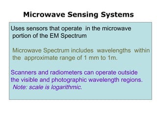
  • 1. Microwave Sensing Systems Uses sensors that operate in the microwave portion of the EM Spectrum Microwave Spectrum includes wavelengths within the approximate range of 1 mm to 1m. Scanners and radiometers can operate outside the visible and photographic wavelength regions. Note: scale is logarithmic.
  • 2.
  • 3. ● Electromagnetic Spectrum  Visible (VIS) : 0.4 µm to 0.7 µm (400 to 700 nanometers)  Infrared (IR): 0.7 µm to 14 µm  Microwave : 1 mm to 1 m In the visible, features are observed by virtue of reflected solar energy. By contrast, in the infrared portion, sensing of emitted energy predominates. The dividing line between sensing reflected and emitted radiation is the wavelength of ~3 µm.
  • 4.
  • 5.
  • 6. Radar is an acronym for Radio Detection and Ranging. Radar is an active sensor systems. It generates its own illumination as an outgoing signal that interacts with the target such that some of the signal is returned as backscatter that is picked up by the same antenna that emitted the radar beam. Radar operates in part of the microwave region of the electromagnetic spectrum, specifically in the frequency interval from 40,000 to 300 megahertz (MHz). The latter frequency extends into the higher frequencies of the broadcast-radio region. Radar
  • 7.
  • 8. Water vapor, dust, smoke, airborne pollutants and other small particles close in magnitude to visible and infrared (VIR) wavelengths cause interference in the path between target and sensor. VIR wavelengths can be dispersed or blocked before they reach the sensors. Since microwaves are longer, they are not as affected by these types of small particle matter. Therefore, sensors transmitting and/or receiving microwaves are able to 'see' through haze, cloud, light rain, snow, smoke, and pollution. As a result, radar images can yield valuable information that is not available in VIR images. Atmospheric Penetration
  • 9.
  • 10.
  • 11.
  • 12.
  • 13.
  • 14.
  • 15.
  • 16.
  • 17. categories of Remote sensing radars Real aperture and Synthetic Aperture Radars (SAR). Side-Looking Airborne Radar (SLAR) Radar altimeter Microwave scatterometer
  • 18. Real aperture radars transmit and receive microwave signals with a fixed length antenna. They are limited in their ability to produce resolutions fine enough for most remote sensing applications, simply because it is difficult to transport a very long antenna. To solve this problem synthetic aperture radars (SAR) were developed. SARs have physically shorter antennas, which simulate or synthesize very long antennas. This is accomplished through modified data recording and signal processing techniques.
  • 19. Side-Looking Airborne Radar (SLAR) A radar pulse is transmitted off-nadir by an antenna fixed below an aircraft to image large ground areas adjacent to the flight line. The echoes are processed to produce an amplitude/time video signal which is then recorded as an image line, with brighter pixels indicating higher energy returns. The oblique look angle used to acquire radar imagery results in characteristic geometric distortions such as radar shadows and layover effects.
  • 20. The propagation of one radar pulse is shown using solid lines to indicate the wavefront locations at time intervals 1 to 12. The reflected waves or echoes are shown by dashed lines beginning at time 7 for the house and 9 for the tree. These return signals reach the antennae at times 13 and 17 respectively.
  • 21. The antennae response graph shows a strong echo for the house at time 13 and a weaker echo for the tree at time 17. The strength of the echo depends on the way an object reflects radio waves.
  • 22. Pixel size in SLAR imagery is determined by the time duration of the pulse and the beamwidth of the SLAR antennae.
  • 23. Radar altimeter This is a non-imaging radar which detects the EM backscattering of a surface from a narrow pulse with near normal incidence. By directing the pulse onto the Earth's surface from a nadir position (that is, directly overhead) the distance being measured is the altitude of the scanning platform above the surface.
  • 24. Radar altimeter Over oceans, radar altimeters are used to determine significant wave height, wind speed and mesoscale topography. Data from this non- imaging device can also be plotted in image format, such as to map sea surface topography, if the required data volume is available. Other applications include mapping surface topography and type of ice masses and sea/ice boundaries.
  • 25.
  • 26. Microwave scatterometer This device measures the microwave scattering or reflective properties of surfaces. It is also non-imaging, and is specifically designed to measure backscattering. The surface is scanned in two or more directions, usually by multiple sensors. The primary application of microwave scatterometers is to measure wind vectors (that is, speed and direction) over the ocean surface. Although radar scatterometers are non- imaging, their data may be used to construct global wind maps when collected over a sufficiently large area.
  • 27. Scatterometer A scatterometer is a microwave radar sensor used to measure the reflection or scattering effect produced while scanning the surface of the earth from an aircraft or a satellite.
  • 28.
  • 29.
  • 30. Two Generic Types of Sensors • A "passive" system generally consists of an array of small sensors or detectors which record the amount of electro-magnetic radiation reflected and/or emitted from the Earth's surface. • An "active" system propagates its own electro- magnetic radiation and measures the intensity of the return signal.
  • 31. Examples of Passive Sensors • Advanced Very High Resolution Radiometer (AVHRR) Sea Surface Temperature • Sea-viewing Wide Field-of-View Sensor (SeaWiFS) Ocean Color
  • 32. Why Sea-Surface-Temperature? • Sea surface temperature (SST) is a key parameter for energy transfer between the oceans and the atmosphere and AVHRR- derived SST can deliver important data to meteorological and climatological models. • AVHRR imagery is also useful for meteorological applications (for example, providing detailed imagery of cloud systems), and land applications such as vegetation mapping and monitoring.
  • 33. Advantages of passive microwave remoteAdvantages of passive microwave remote sensingsensing • Sees through clouds at lower frequencies • Long heritage, various instruments since 1978 • Emissivity sensitive to state of surface, particularly moisture – Soil moisture – Snow-water equivalent – (water is ~80× as absorptive as ice at these frequencies, whereas in visible through infrared, water and ice have similar absorption coefficients) • But, because of small amount of energy emitted, pixel size must be large
  • 34. Microwave Remote Sensing: Principles and Applications. • Advantages – Day/night coverage. – All weather except during periods of heavy rain. – Complementary information to that in optical and IR regions. • Disadvantages – Data are difficult to interpret. – Coarse resolution except for SAR.
  • 35. Infared Satellite Imagery • These images were obtained with an AVHRR sensor (Advanced Very High Resolution Radiometer) carried on a NOAA Polar Orbiting Environmental Satellite (POES). • Measures the amount of thermal infared radiation given off by the surface of the ocean. • The amount of thermal infared radiation given off by an object is related to its temperature (dying embers give off less radiation than a hot fire and a person gives off even less). • Thus by measuring the amount of radiation given off by the ocean we can calculate its temperature.
  • 36. Infared Satellite Imagery • These images were obtained with an AVHRR sensor (Advanced Very High Resolution Radiometer) carried on a NOAA Polar Orbiting Environmental Satellite (POES). • Measures the amount of thermal infared radiation given off by the surface of the ocean. • The amount of thermal infared radiation given off by an object is related to its temperature (dying embers give off less radiation than a hot fire and a person gives off even less). • Thus by measuring the amount of radiation given off by the ocean we can calculate its temperature.