SlideShare uma empresa Scribd logo
1 de 4
PRAMOD RAJGOWDA 1
Useful notes on Geographical Cycle of Erosion
The concept of geographical cycle of erosionrecognises the possibility of obliteration of relief,
or planation, during the life history of a landscape, by process of erosion, occurring in a
sequence of orderly changes, finally reducing the landscape relief to a minimum.
The earth scientists have attempted to interpret geomorphological processes or forces on the
basis of these cycles of erosion.
Views of William Morris Davis:
Davis defined a geographical cycle as that sequence of changes which an uplifted block has to
undergo before it gets reduced to base level or peneplane.
He postulated that a geographical cycle is a function of three factors:
1. Structure: Which includes ‘nature’ (hardness, permeability) and ‘attitude’ (folds, faults,
joints, slopes) of rocks?
2. Process: Implies the factors or agents responsible for weathering and erosion.
3. Time: Implies the stage at which the cycle is—youth, maturity or old age.
Davisian Cycle of Erosion:
The major assumption which Davis made was that the erosionstarts only after the uplift has
stopped.
Youth:
The uplift is complete and has stopped. Immediately erosion of the uplifted block sets in. The
streams follow initial irregularities available without adjusting to the structure. These are
consequent streams. The floors of the valley suffer down cutting while the summits remain
almost unaffected. Increased relief heralds the beginning of mature age, indicated by widening
of the gap between lines ‘A’ and ‘B’ (Fig. 1.44).
Maturity:
At this stage, the vertical erosion slows down and the horizontal action increases. A
characteristic feature is the erosionof mountain tops at a faster rate than lowering of the valley
floor. The coming closer of lines ‘A’ and ‘B’ indicates emergence of a gentle slope. The
subsequent streams gain importance now.
Old Age:
A gentle gradient, accentuated by horizontal action and deposition, reduces the erosion intensity.
A thick layer of sediment represents the earlier erosion activity. The landforms get mellowed—
PRAMOD RAJGOWDA 2
lines ‘A’ and ‘B’ run parallel to each other. Relicts of mountains or monad knocks are dotting
the water divides and a featureless plain—peneplane is produced.
Positive Aspects:
1. The Davisian cycle affords a genetic classification and nomenclature of landscape, as
compared to a morphological one and provides the means of expressing texture and the build of
a landscape.
2. The consideration by Davis of change in base level as indication of the initiation of a new
cycle has certain advantages. One, the base level change can be considered a unit of time
compared to the geologists’ stratigraphical time unit. Two, the base level changes during
glaciations are accommodated.
Drawbacks:
1. In a way, the geographical cycle proposed by Davis is backward looking as it considers
complete suspension of uplift after the erosionhas set in.
2. There are no logical grounds for the assumption that flat slopes are old and steep slopes are
young. Other variables controlling the slope are nature of soil material and the bedrock, climate,
vegetation and the downslope factors acting at the slope foot.
3. An ideal Davisian cycle would take millions of years to complete. What about the earth
movements during the cycle?
4. Too much of generalisation in the Davisian cycle presents an inadequate framework for
landform interpretation.
5. There is little evidence to prove that landforms actually evolve to an end product or
peneplane.
Views of Penck:
Penck made certain deviations from the views of Davis. One, the erosiondoes not remain
suspended till the uplift is complete. In fact, he said, the geomorphic forms are an expression of
PRAMOD RAJGOWDA 3
the phase and rate of uplift in relation to the rate of degradation, and that interaction between the
two factors, uplift and degradation, is continuous. Two, the rate of uplift keeps changing.
Penck proposed three types of valley slopes on the basis of erosional intensity acting on crustal
movements.
1. Straight slope:
Indicating uniform erosionintensity and a uniform development of landforms or ‘Gleichformige
Entwickelung’ in German.
2. Convex slope:
Indicating waxing erosionintensity and a waxing development of landforms or ‘Aufsteigende
Entwickelung.
3. Concave slope:
Indicating waning erosionintensity and a waning development of landforms or ‘Absteigende
Entwickelung.’
Penck’s Cycle of Erosion:
Refer, to Fig. 1.46. The cycle has several stages.
Stage 1:
With uplift, the interfluves, as well as the lower parts, rise. There is a lack of brisk undercutting.
Penck used the term ‘Primarumpf’ to represent the characteristic landscape before upliftment.
Primarumpf is, in fact, initial surface or primary peneplane representing either newly emerged
surface from below sea level or a ‘fastenbene’ or ‘peneplane’ type of land surface converted into
featureless landmass by uplift.
Stage 2:
Here, the rate, of downcutting is less than the rate of uplift. There is not much change in relief.
Stage 3:
Rate of downcutting becomes equal to the rate of uplift. Again, there is not much change in
relief.
Stage 4:
PRAMOD RAJGOWDA 4
Uplift comes to an end and the downcutting further intensifies. The height of interfluves
decreases. Deepening of valleys accelerates. A convex slope results: this is the stage of waxing
erosionor Aufsteigende Entwickelung.
Stage 5:
The downcutting and the deepening of valleys slows down. The interfluves are rounded and
further lowered. A concave slope results: this is the stage of waning erosion or Absteigende
Entwickelung.
Stage 6:
Uniform erosionor Gleichformige Entwickelung characterises the end product— endruiripf or
endplain.
Positive Points:
1. Penck followed a deductive approach and did not restrict himself to any particular condition.
2. Compared to the Davisian cycle, Penck’s approach was forward looking.
3. Penck, quite appropriately, emphasised the mutual relation between uplift and the deepening
of valleys. This indicates Penck’s respect for geological evidence. Penck’s third stage is evident
in the Middle Alps.
Drawbacks:
1. Penck gave too much importance to the role of endogenetic forces.
2. The orderliness in landform changes, as assumed by Penck, may be difficult to achieve.
3. Inadequate knowledge about the initial pristine landscape does not allow much verification.
4. The concept of geographical cycle of erosion itself has been criticisedby many, since many of
the cyclic generalisations are based on untested assumptions. An overemphasis on historical and
evolutionary studies in landforms results in the reconstructionof stages of evolution becoming
the focus of study.

Mais conteúdo relacionado

Mais procurados

Geomorphology applications
Geomorphology applicationsGeomorphology applications
Geomorphology applications
vyshalik
 
Fluvial landforms
Fluvial landformsFluvial landforms
Fluvial landforms
Ms Geoflake
 

Mais procurados (20)

Geomorpholgy: NATURE AND SCOPE
Geomorpholgy: NATURE AND SCOPEGeomorpholgy: NATURE AND SCOPE
Geomorpholgy: NATURE AND SCOPE
 
Drainage pattern and their significance
Drainage pattern and their significanceDrainage pattern and their significance
Drainage pattern and their significance
 
King's model-Geomorhology Chapter
King's model-Geomorhology ChapterKing's model-Geomorhology Chapter
King's model-Geomorhology Chapter
 
Erosional & depositional glacial landforms
Erosional & depositional glacial landformsErosional & depositional glacial landforms
Erosional & depositional glacial landforms
 
Fundamental concepts of geomorphology
Fundamental concepts of geomorphologyFundamental concepts of geomorphology
Fundamental concepts of geomorphology
 
APPLIED GEOMORPHOLOGY ppt.pptx
APPLIED GEOMORPHOLOGY ppt.pptxAPPLIED GEOMORPHOLOGY ppt.pptx
APPLIED GEOMORPHOLOGY ppt.pptx
 
Geomorphology applications
Geomorphology applicationsGeomorphology applications
Geomorphology applications
 
Geomorophology presentation
Geomorophology presentationGeomorophology presentation
Geomorophology presentation
 
Isostasy
IsostasyIsostasy
Isostasy
 
Geosyncline
Geosyncline Geosyncline
Geosyncline
 
Drainage basin morphometry
Drainage basin morphometry Drainage basin morphometry
Drainage basin morphometry
 
Fluvial landforms
Fluvial landformsFluvial landforms
Fluvial landforms
 
Davis Theory -William Morris Davis- Geomophology Chapter
Davis Theory -William Morris Davis- Geomophology ChapterDavis Theory -William Morris Davis- Geomophology Chapter
Davis Theory -William Morris Davis- Geomophology Chapter
 
Types Drainage pattern presentation
Types Drainage pattern presentationTypes Drainage pattern presentation
Types Drainage pattern presentation
 
Erosional and depositional landforms
Erosional and depositional landformsErosional and depositional landforms
Erosional and depositional landforms
 
Evolution of Geomorphic theory- Geomorphology Chapter
Evolution of Geomorphic theory- Geomorphology ChapterEvolution of Geomorphic theory- Geomorphology Chapter
Evolution of Geomorphic theory- Geomorphology Chapter
 
Models of landscape evolution and slope development by king
Models of landscape evolution and slope development by kingModels of landscape evolution and slope development by king
Models of landscape evolution and slope development by king
 
Fluvial process
Fluvial processFluvial process
Fluvial process
 
Introduction to geomorphology
Introduction to geomorphologyIntroduction to geomorphology
Introduction to geomorphology
 
Fundmetal concepts of geomorphology
Fundmetal concepts of geomorphologyFundmetal concepts of geomorphology
Fundmetal concepts of geomorphology
 

Semelhante a Davis cycle of erosion

Semelhante a Davis cycle of erosion (20)

Davis Theory -William Morris Davis- Geomophology Chapter
Davis Theory -William Morris Davis- Geomophology ChapterDavis Theory -William Morris Davis- Geomophology Chapter
Davis Theory -William Morris Davis- Geomophology Chapter
 
Cycle of Erosion.pptx
Cycle of Erosion.pptxCycle of Erosion.pptx
Cycle of Erosion.pptx
 
02 diagenesis
02 diagenesis02 diagenesis
02 diagenesis
 
Cycle of erosion
Cycle of erosionCycle of erosion
Cycle of erosion
 
Geomorphology good pdf.pdf
Geomorphology good pdf.pdfGeomorphology good pdf.pdf
Geomorphology good pdf.pdf
 
Syn rift
Syn riftSyn rift
Syn rift
 
Types-of-Slopes.pdf
Types-of-Slopes.pdfTypes-of-Slopes.pdf
Types-of-Slopes.pdf
 
Erosion and sedimentation
Erosion and sedimentationErosion and sedimentation
Erosion and sedimentation
 
Sequence Stratigraphy.pptx
Sequence Stratigraphy.pptxSequence Stratigraphy.pptx
Sequence Stratigraphy.pptx
 
Geo-morphology notes
Geo-morphology notes Geo-morphology notes
Geo-morphology notes
 
LGC field course in the Book Cliffs, UT: Presentation 1 of 14 (Principles of ...
LGC field course in the Book Cliffs, UT: Presentation 1 of 14 (Principles of ...LGC field course in the Book Cliffs, UT: Presentation 1 of 14 (Principles of ...
LGC field course in the Book Cliffs, UT: Presentation 1 of 14 (Principles of ...
 
Divergent plate boundary PPT
Divergent plate boundary PPTDivergent plate boundary PPT
Divergent plate boundary PPT
 
Growth Fault.pdf
Growth Fault.pdfGrowth Fault.pdf
Growth Fault.pdf
 
Growth Fault.pdf
Growth Fault.pdfGrowth Fault.pdf
Growth Fault.pdf
 
Growth Fault.pdf
Growth Fault.pdfGrowth Fault.pdf
Growth Fault.pdf
 
Growth Fault.pdf
Growth Fault.pdfGrowth Fault.pdf
Growth Fault.pdf
 
fan systems.pptx
fan systems.pptxfan systems.pptx
fan systems.pptx
 
Mass movement
 Mass movement Mass movement
Mass movement
 
Mass Movement
Mass MovementMass Movement
Mass Movement
 
Principles of Stratigraphy
Principles of StratigraphyPrinciples of Stratigraphy
Principles of Stratigraphy
 

Mais de Pramoda Raj

Mais de Pramoda Raj (20)

Aerial photography.pptx
Aerial photography.pptxAerial photography.pptx
Aerial photography.pptx
 
Siwalik- Stratigraphy
Siwalik- StratigraphySiwalik- Stratigraphy
Siwalik- Stratigraphy
 
Hydrogeology
HydrogeologyHydrogeology
Hydrogeology
 
Waves and their significance
Waves and their significanceWaves and their significance
Waves and their significance
 
coastal erosion
coastal erosioncoastal erosion
coastal erosion
 
Glacial processes and their land forms.
Glacial processes and their land forms.Glacial processes and their land forms.
Glacial processes and their land forms.
 
Dams
Dams Dams
Dams
 
Upsc geologist syllabus exam pattern
Upsc geologist syllabus exam patternUpsc geologist syllabus exam pattern
Upsc geologist syllabus exam pattern
 
Role of non government organizations in disaster management
Role of non government organizations in disaster managementRole of non government organizations in disaster management
Role of non government organizations in disaster management
 
Disaster Management System in India - Notes
Disaster Management System in India - Notes Disaster Management System in India - Notes
Disaster Management System in India - Notes
 
Role of non government organizations in disaster management
Role of non government organizations in disaster managementRole of non government organizations in disaster management
Role of non government organizations in disaster management
 
Disaster management system in India
Disaster management system in IndiaDisaster management system in India
Disaster management system in India
 
International organizations in disaster management
International organizations in disaster managementInternational organizations in disaster management
International organizations in disaster management
 
Geological factor for canal alignment
Geological factor for canal alignmentGeological factor for canal alignment
Geological factor for canal alignment
 
Major extinction events
Major extinction eventsMajor extinction events
Major extinction events
 
Coastal erosion and engineering aspect
Coastal erosion and engineering aspectCoastal erosion and engineering aspect
Coastal erosion and engineering aspect
 
Geotextiles
GeotextilesGeotextiles
Geotextiles
 
Hazard mapping
Hazard mappingHazard mapping
Hazard mapping
 
Sampling techniques
Sampling techniquesSampling techniques
Sampling techniques
 
Faults
FaultsFaults
Faults
 

Último

1029-Danh muc Sach Giao Khoa khoi 6.pdf
1029-Danh muc Sach Giao Khoa khoi  6.pdf1029-Danh muc Sach Giao Khoa khoi  6.pdf
1029-Danh muc Sach Giao Khoa khoi 6.pdf
QucHHunhnh
 
Making and Justifying Mathematical Decisions.pdf
Making and Justifying Mathematical Decisions.pdfMaking and Justifying Mathematical Decisions.pdf
Making and Justifying Mathematical Decisions.pdf
Chris Hunter
 
Beyond the EU: DORA and NIS 2 Directive's Global Impact
Beyond the EU: DORA and NIS 2 Directive's Global ImpactBeyond the EU: DORA and NIS 2 Directive's Global Impact
Beyond the EU: DORA and NIS 2 Directive's Global Impact
PECB
 
The basics of sentences session 3pptx.pptx
The basics of sentences session 3pptx.pptxThe basics of sentences session 3pptx.pptx
The basics of sentences session 3pptx.pptx
heathfieldcps1
 

Último (20)

Key note speaker Neum_Admir Softic_ENG.pdf
Key note speaker Neum_Admir Softic_ENG.pdfKey note speaker Neum_Admir Softic_ENG.pdf
Key note speaker Neum_Admir Softic_ENG.pdf
 
Unit-IV; Professional Sales Representative (PSR).pptx
Unit-IV; Professional Sales Representative (PSR).pptxUnit-IV; Professional Sales Representative (PSR).pptx
Unit-IV; Professional Sales Representative (PSR).pptx
 
General Principles of Intellectual Property: Concepts of Intellectual Proper...
General Principles of Intellectual Property: Concepts of Intellectual  Proper...General Principles of Intellectual Property: Concepts of Intellectual  Proper...
General Principles of Intellectual Property: Concepts of Intellectual Proper...
 
Class 11th Physics NEET formula sheet pdf
Class 11th Physics NEET formula sheet pdfClass 11th Physics NEET formula sheet pdf
Class 11th Physics NEET formula sheet pdf
 
1029-Danh muc Sach Giao Khoa khoi 6.pdf
1029-Danh muc Sach Giao Khoa khoi  6.pdf1029-Danh muc Sach Giao Khoa khoi  6.pdf
1029-Danh muc Sach Giao Khoa khoi 6.pdf
 
ICT Role in 21st Century Education & its Challenges.pptx
ICT Role in 21st Century Education & its Challenges.pptxICT Role in 21st Century Education & its Challenges.pptx
ICT Role in 21st Century Education & its Challenges.pptx
 
INDIA QUIZ 2024 RLAC DELHI UNIVERSITY.pptx
INDIA QUIZ 2024 RLAC DELHI UNIVERSITY.pptxINDIA QUIZ 2024 RLAC DELHI UNIVERSITY.pptx
INDIA QUIZ 2024 RLAC DELHI UNIVERSITY.pptx
 
Making and Justifying Mathematical Decisions.pdf
Making and Justifying Mathematical Decisions.pdfMaking and Justifying Mathematical Decisions.pdf
Making and Justifying Mathematical Decisions.pdf
 
Role Of Transgenic Animal In Target Validation-1.pptx
Role Of Transgenic Animal In Target Validation-1.pptxRole Of Transgenic Animal In Target Validation-1.pptx
Role Of Transgenic Animal In Target Validation-1.pptx
 
Beyond the EU: DORA and NIS 2 Directive's Global Impact
Beyond the EU: DORA and NIS 2 Directive's Global ImpactBeyond the EU: DORA and NIS 2 Directive's Global Impact
Beyond the EU: DORA and NIS 2 Directive's Global Impact
 
Unit-IV- Pharma. Marketing Channels.pptx
Unit-IV- Pharma. Marketing Channels.pptxUnit-IV- Pharma. Marketing Channels.pptx
Unit-IV- Pharma. Marketing Channels.pptx
 
PROCESS RECORDING FORMAT.docx
PROCESS      RECORDING        FORMAT.docxPROCESS      RECORDING        FORMAT.docx
PROCESS RECORDING FORMAT.docx
 
Sociology 101 Demonstration of Learning Exhibit
Sociology 101 Demonstration of Learning ExhibitSociology 101 Demonstration of Learning Exhibit
Sociology 101 Demonstration of Learning Exhibit
 
Measures of Dispersion and Variability: Range, QD, AD and SD
Measures of Dispersion and Variability: Range, QD, AD and SDMeasures of Dispersion and Variability: Range, QD, AD and SD
Measures of Dispersion and Variability: Range, QD, AD and SD
 
The basics of sentences session 3pptx.pptx
The basics of sentences session 3pptx.pptxThe basics of sentences session 3pptx.pptx
The basics of sentences session 3pptx.pptx
 
microwave assisted reaction. General introduction
microwave assisted reaction. General introductionmicrowave assisted reaction. General introduction
microwave assisted reaction. General introduction
 
Z Score,T Score, Percential Rank and Box Plot Graph
Z Score,T Score, Percential Rank and Box Plot GraphZ Score,T Score, Percential Rank and Box Plot Graph
Z Score,T Score, Percential Rank and Box Plot Graph
 
This PowerPoint helps students to consider the concept of infinity.
This PowerPoint helps students to consider the concept of infinity.This PowerPoint helps students to consider the concept of infinity.
This PowerPoint helps students to consider the concept of infinity.
 
ComPTIA Overview | Comptia Security+ Book SY0-701
ComPTIA Overview | Comptia Security+ Book SY0-701ComPTIA Overview | Comptia Security+ Book SY0-701
ComPTIA Overview | Comptia Security+ Book SY0-701
 
TỔNG ÔN TẬP THI VÀO LỚP 10 MÔN TIẾNG ANH NĂM HỌC 2023 - 2024 CÓ ĐÁP ÁN (NGỮ Â...
TỔNG ÔN TẬP THI VÀO LỚP 10 MÔN TIẾNG ANH NĂM HỌC 2023 - 2024 CÓ ĐÁP ÁN (NGỮ Â...TỔNG ÔN TẬP THI VÀO LỚP 10 MÔN TIẾNG ANH NĂM HỌC 2023 - 2024 CÓ ĐÁP ÁN (NGỮ Â...
TỔNG ÔN TẬP THI VÀO LỚP 10 MÔN TIẾNG ANH NĂM HỌC 2023 - 2024 CÓ ĐÁP ÁN (NGỮ Â...
 

Davis cycle of erosion

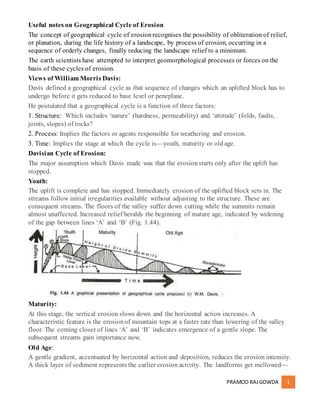
  • 1. PRAMOD RAJGOWDA 1 Useful notes on Geographical Cycle of Erosion The concept of geographical cycle of erosionrecognises the possibility of obliteration of relief, or planation, during the life history of a landscape, by process of erosion, occurring in a sequence of orderly changes, finally reducing the landscape relief to a minimum. The earth scientists have attempted to interpret geomorphological processes or forces on the basis of these cycles of erosion. Views of William Morris Davis: Davis defined a geographical cycle as that sequence of changes which an uplifted block has to undergo before it gets reduced to base level or peneplane. He postulated that a geographical cycle is a function of three factors: 1. Structure: Which includes ‘nature’ (hardness, permeability) and ‘attitude’ (folds, faults, joints, slopes) of rocks? 2. Process: Implies the factors or agents responsible for weathering and erosion. 3. Time: Implies the stage at which the cycle is—youth, maturity or old age. Davisian Cycle of Erosion: The major assumption which Davis made was that the erosionstarts only after the uplift has stopped. Youth: The uplift is complete and has stopped. Immediately erosion of the uplifted block sets in. The streams follow initial irregularities available without adjusting to the structure. These are consequent streams. The floors of the valley suffer down cutting while the summits remain almost unaffected. Increased relief heralds the beginning of mature age, indicated by widening of the gap between lines ‘A’ and ‘B’ (Fig. 1.44). Maturity: At this stage, the vertical erosion slows down and the horizontal action increases. A characteristic feature is the erosionof mountain tops at a faster rate than lowering of the valley floor. The coming closer of lines ‘A’ and ‘B’ indicates emergence of a gentle slope. The subsequent streams gain importance now. Old Age: A gentle gradient, accentuated by horizontal action and deposition, reduces the erosion intensity. A thick layer of sediment represents the earlier erosion activity. The landforms get mellowed—
  • 2. PRAMOD RAJGOWDA 2 lines ‘A’ and ‘B’ run parallel to each other. Relicts of mountains or monad knocks are dotting the water divides and a featureless plain—peneplane is produced. Positive Aspects: 1. The Davisian cycle affords a genetic classification and nomenclature of landscape, as compared to a morphological one and provides the means of expressing texture and the build of a landscape. 2. The consideration by Davis of change in base level as indication of the initiation of a new cycle has certain advantages. One, the base level change can be considered a unit of time compared to the geologists’ stratigraphical time unit. Two, the base level changes during glaciations are accommodated. Drawbacks: 1. In a way, the geographical cycle proposed by Davis is backward looking as it considers complete suspension of uplift after the erosionhas set in. 2. There are no logical grounds for the assumption that flat slopes are old and steep slopes are young. Other variables controlling the slope are nature of soil material and the bedrock, climate, vegetation and the downslope factors acting at the slope foot. 3. An ideal Davisian cycle would take millions of years to complete. What about the earth movements during the cycle? 4. Too much of generalisation in the Davisian cycle presents an inadequate framework for landform interpretation. 5. There is little evidence to prove that landforms actually evolve to an end product or peneplane. Views of Penck: Penck made certain deviations from the views of Davis. One, the erosiondoes not remain suspended till the uplift is complete. In fact, he said, the geomorphic forms are an expression of
  • 3. PRAMOD RAJGOWDA 3 the phase and rate of uplift in relation to the rate of degradation, and that interaction between the two factors, uplift and degradation, is continuous. Two, the rate of uplift keeps changing. Penck proposed three types of valley slopes on the basis of erosional intensity acting on crustal movements. 1. Straight slope: Indicating uniform erosionintensity and a uniform development of landforms or ‘Gleichformige Entwickelung’ in German. 2. Convex slope: Indicating waxing erosionintensity and a waxing development of landforms or ‘Aufsteigende Entwickelung. 3. Concave slope: Indicating waning erosionintensity and a waning development of landforms or ‘Absteigende Entwickelung.’ Penck’s Cycle of Erosion: Refer, to Fig. 1.46. The cycle has several stages. Stage 1: With uplift, the interfluves, as well as the lower parts, rise. There is a lack of brisk undercutting. Penck used the term ‘Primarumpf’ to represent the characteristic landscape before upliftment. Primarumpf is, in fact, initial surface or primary peneplane representing either newly emerged surface from below sea level or a ‘fastenbene’ or ‘peneplane’ type of land surface converted into featureless landmass by uplift. Stage 2: Here, the rate, of downcutting is less than the rate of uplift. There is not much change in relief. Stage 3: Rate of downcutting becomes equal to the rate of uplift. Again, there is not much change in relief. Stage 4:
  • 4. PRAMOD RAJGOWDA 4 Uplift comes to an end and the downcutting further intensifies. The height of interfluves decreases. Deepening of valleys accelerates. A convex slope results: this is the stage of waxing erosionor Aufsteigende Entwickelung. Stage 5: The downcutting and the deepening of valleys slows down. The interfluves are rounded and further lowered. A concave slope results: this is the stage of waning erosion or Absteigende Entwickelung. Stage 6: Uniform erosionor Gleichformige Entwickelung characterises the end product— endruiripf or endplain. Positive Points: 1. Penck followed a deductive approach and did not restrict himself to any particular condition. 2. Compared to the Davisian cycle, Penck’s approach was forward looking. 3. Penck, quite appropriately, emphasised the mutual relation between uplift and the deepening of valleys. This indicates Penck’s respect for geological evidence. Penck’s third stage is evident in the Middle Alps. Drawbacks: 1. Penck gave too much importance to the role of endogenetic forces. 2. The orderliness in landform changes, as assumed by Penck, may be difficult to achieve. 3. Inadequate knowledge about the initial pristine landscape does not allow much verification. 4. The concept of geographical cycle of erosion itself has been criticisedby many, since many of the cyclic generalisations are based on untested assumptions. An overemphasis on historical and evolutionary studies in landforms results in the reconstructionof stages of evolution becoming the focus of study.