SlideShare uma empresa Scribd logo
1 de 1
Baixar para ler offline
low 
(1.4 m/ha) 
high 
(583.1 m/ha) 
•annual average rainfall: ~1000÷1300 mm, 
•averageannualtemperature: from 14.5°C (Arno plain) to 10.2°C (M.te Serra) Results 
Mediterranean landscapes characterization 
Land Lab 
Saint Anna School of Advanced Studies 
via Santa Cecilia, 3 56127 Pisa –Italia 
* davide@sssup.it 
Since the 1960s the agricultural exploitation and management of the territory declined due to the decreasing number of farmers. Study area (Monte Pisano, NW Tuscany) 
Geomorphological and climatic constraints implied the need to optimize the production capabilities, modifying the slopes with intensive drainage systems, widely using the dry-stone walls terracing (Galli et al., 2003), as in other hilly areas in Italy and Europe. 
•max. height: Monte Serra, 917 m 
•average slope37%; 
•over than the 80% of the area has a slope > 20% 
BaldeschiP., Il Chianti fiorentino, un progetto di tutela del paesaggio, Bari, Laterza, 2000. 
Brancucci G., Ghersi A., Ruggiero M.E., Paesaggi liguri a terrazze: riflessioni per una metodologia di studio, Firenze, Alinea Editrice, 2000. 
Galli M., Pieroni P., Brunori G.,«Un’esperienza di ricerca partecipativa per la valorizzazione degli spazi rurali nel comprensorio del Monte Pisano»,Estimo e territorio –Rivista di scienze ambientali, vol. LXVI, n°3, 2003: p. 54-63. 
Parvex F., Turiel A., Sauvegarde des murs en pierres sèches et du vignoble en terrasses valaisan,Sierre (Switzerland), SEREC, 2001. 
Ogrin D., «Mediterranean landscapes: contribution to a better management», Report commissioned by Priority Actions Programme, 2005. 
Key references 
permanent crops 
urban fabric 
other abandonedcrops 
semi-natural areas & woods 
abandonedolive groves 
rivers 
arable lands 
mixed crops 
pastures 
First results quantitatively characterize the terraced landscape, focussing on the linksbetweendrainagestructuresandcultivationstate(i.e. abandonment). 
Dry-stone walls density 
Define a studymethodology 
focussing on data requirement to understand the agronomicfacetsof terraced landscape degradation, 
and develop supports for their future management. Aim 
agrarian landscapes as system of landmarks 
role of farming activitiesas the main drivers in their making and management 
farmers’ choices 
to express the productive capabilities of soils 
managelimiting factors 
augment useefficiencyof the disposable resources 
permanent landmarks 
superimposing to the territory an agronomic controlfactor 
drainage systems for the management and conservation of soil and water resources 
bench terraces 
olive groves & vineyards 
abandoned olive groves 
ciglioni 
dry-stone walls terracesNdata integration 
Land cover 
 
The available data were at a resolution too coarse neither not uniform and complete for the details of the classes. 
Therefore a new map has been done, whose classes are defined on the standard CORINE land cover nomenclature. 
Survey of present time agricultural activities (cultivated versus abandoned). 
The new class “abandoned olive groves” has been defined on a specific area knowledge and field observation. 
Cultivation 
state 
 
A proper methodology for their characterization is still poorly defined in literature. 
We followed three steps: 
(1) the description of the various drainage structure typologies, 
(2) their localization through photointerpretation, 
(3) the gathering of related quantitative data. 
Drainage 
structures 
 Theoretical frameworkConclusions 
Working within a GIS provided a profitable and operative supporttoplantheactiveconservationof terraced landscapes, through the localization and prioritization of their management needs. 
This degradation cannot be completely understood using a classical geo-morphological approach but it shall be integratedwithagronomicparametersfor their key role in the terraced systems conservation. 
•available data 
•technical documents 
•topographic maps 
•aerial photos 
decision support system 
drainage structures 
management priorities 
(ongoing analysis) Methodology 
1. collect 
3. evaluate 
4.manage 
2. integrate 
geo 
database 
existing knowledge 
field surveys 
photointerpretation 
•land cover 
•cultivations state 
•drainage structures 
•localization 
•quantification 
•classification 
•quantification 
cultivated olive groves 
but unmanaged dry-stone walls 
dry-stone walls terraces 
terraces held-up by turf (ciglioni) 
pocket terraces 
rubble-wall terraces 
The terraced landscapes in European Mediterranean areas are increasingly exposed to degradationas a consequence of their changed management 
pocket terraces 
Drainage structures 
The landscapecharacterizationhighlighted the relevance of a landscapedegradationin terms of retaining walls fell-down, insufficient drainage, micro-landslides, etc). 
Land cover & abandonmentwww.land-lab.org 
mapping and analysis of the terraced olive groves on Monte Pisano 
Davide Rizzo*, Tiziana Sabbatini, Mariassunta Galli, Enrico Bonari

Mais conteúdo relacionado

Mais procurados

Application of GIS and RS in Watershed Management
Application of GIS and RS in Watershed ManagementApplication of GIS and RS in Watershed Management
Application of GIS and RS in Watershed Managementholegajendra
 
Characterizing Forest Degradation using Multiple SAR Approaches
Characterizing Forest Degradation using Multiple SAR ApproachesCharacterizing Forest Degradation using Multiple SAR Approaches
Characterizing Forest Degradation using Multiple SAR ApproachesCIFOR-ICRAF
 
Reducing uncertainty in carbon cycle science of North America: a synthesis pr...
Reducing uncertainty in carbon cycle science of North America: a synthesis pr...Reducing uncertainty in carbon cycle science of North America: a synthesis pr...
Reducing uncertainty in carbon cycle science of North America: a synthesis pr...National Institute of Food and Agriculture
 
LAND USE /LAND COVER CLASSIFICATION AND CHANGE DETECTION USING GEOGRAPHICAL I...
LAND USE /LAND COVER CLASSIFICATION AND CHANGE DETECTION USING GEOGRAPHICAL I...LAND USE /LAND COVER CLASSIFICATION AND CHANGE DETECTION USING GEOGRAPHICAL I...
LAND USE /LAND COVER CLASSIFICATION AND CHANGE DETECTION USING GEOGRAPHICAL I...IAEME Publication
 
Soil loss impacts on food security: a case study on LSLA in Mozambique
Soil loss impacts on food security: a case study on LSLA in Mozambique Soil loss impacts on food security: a case study on LSLA in Mozambique
Soil loss impacts on food security: a case study on LSLA in Mozambique ExternalEvents
 
Digital Soil Mapping by Ronald Vargas Rojas
Digital Soil Mapping by Ronald Vargas RojasDigital Soil Mapping by Ronald Vargas Rojas
Digital Soil Mapping by Ronald Vargas RojasFAO
 
Application of GIS and Remote Sensing in the analysis of Landuse/Landcover ch...
Application of GIS and Remote Sensing in the analysis of Landuse/Landcover ch...Application of GIS and Remote Sensing in the analysis of Landuse/Landcover ch...
Application of GIS and Remote Sensing in the analysis of Landuse/Landcover ch...ADITYA SHRESHTKAR
 
Mapping Your Property for Optimal Land Use, Cultivate 2016
Mapping Your Property for Optimal Land Use, Cultivate 2016Mapping Your Property for Optimal Land Use, Cultivate 2016
Mapping Your Property for Optimal Land Use, Cultivate 2016Sara Harding
 
Landuse and Landcover analysis using Remote Sensing and GIS: A Case Study in ...
Landuse and Landcover analysis using Remote Sensing and GIS: A Case Study in ...Landuse and Landcover analysis using Remote Sensing and GIS: A Case Study in ...
Landuse and Landcover analysis using Remote Sensing and GIS: A Case Study in ...IRJET Journal
 
2 rangeland-suitability-evaluation(1)
2 rangeland-suitability-evaluation(1)2 rangeland-suitability-evaluation(1)
2 rangeland-suitability-evaluation(1)AderawTsegaye
 
Land Use Land Cover Change Detection of Gulbarga City Using Remote Sensing an...
Land Use Land Cover Change Detection of Gulbarga City Using Remote Sensing an...Land Use Land Cover Change Detection of Gulbarga City Using Remote Sensing an...
Land Use Land Cover Change Detection of Gulbarga City Using Remote Sensing an...ijsrd.com
 
Soil mapping approach in gis
Soil mapping approach in gisSoil mapping approach in gis
Soil mapping approach in gisSakthivel R
 
Remote Sensing And GIS Application In Wetland Mapping
Remote Sensing And GIS Application In Wetland MappingRemote Sensing And GIS Application In Wetland Mapping
Remote Sensing And GIS Application In Wetland MappingSwetha A
 
Land Use and Land Cover change monitoring of Surajpur Wetland, Uttar Pradesh:...
Land Use and Land Cover change monitoring of Surajpur Wetland, Uttar Pradesh:...Land Use and Land Cover change monitoring of Surajpur Wetland, Uttar Pradesh:...
Land Use and Land Cover change monitoring of Surajpur Wetland, Uttar Pradesh:...Arnab Saha
 
Assessment of Land Use Land Cover Classification through Geospatial Approach:...
Assessment of Land Use Land Cover Classification through Geospatial Approach:...Assessment of Land Use Land Cover Classification through Geospatial Approach:...
Assessment of Land Use Land Cover Classification through Geospatial Approach:...Premier Publishers
 
Soil Organic Carbon mapping by geo- and class- matching
Soil Organic Carbon mapping by geo- and class- matchingSoil Organic Carbon mapping by geo- and class- matching
Soil Organic Carbon mapping by geo- and class- matchingExternalEvents
 
Simulation of sediment transport to Sawah rice fields by applying the water e...
Simulation of sediment transport to Sawah rice fields by applying the water e...Simulation of sediment transport to Sawah rice fields by applying the water e...
Simulation of sediment transport to Sawah rice fields by applying the water e...Eric Takyi Atakora , Ph.D (candidate)
 
Predicting and mapping soil properties using proximal/remote sensing by Zhou ...
Predicting and mapping soil properties using proximal/remote sensing by Zhou ...Predicting and mapping soil properties using proximal/remote sensing by Zhou ...
Predicting and mapping soil properties using proximal/remote sensing by Zhou ...FAO
 

Mais procurados (20)

Application of GIS and RS in Watershed Management
Application of GIS and RS in Watershed ManagementApplication of GIS and RS in Watershed Management
Application of GIS and RS in Watershed Management
 
Characterizing Forest Degradation using Multiple SAR Approaches
Characterizing Forest Degradation using Multiple SAR ApproachesCharacterizing Forest Degradation using Multiple SAR Approaches
Characterizing Forest Degradation using Multiple SAR Approaches
 
Reducing uncertainty in carbon cycle science of North America: a synthesis pr...
Reducing uncertainty in carbon cycle science of North America: a synthesis pr...Reducing uncertainty in carbon cycle science of North America: a synthesis pr...
Reducing uncertainty in carbon cycle science of North America: a synthesis pr...
 
Application of rs and gis
Application of rs and gisApplication of rs and gis
Application of rs and gis
 
LAND USE /LAND COVER CLASSIFICATION AND CHANGE DETECTION USING GEOGRAPHICAL I...
LAND USE /LAND COVER CLASSIFICATION AND CHANGE DETECTION USING GEOGRAPHICAL I...LAND USE /LAND COVER CLASSIFICATION AND CHANGE DETECTION USING GEOGRAPHICAL I...
LAND USE /LAND COVER CLASSIFICATION AND CHANGE DETECTION USING GEOGRAPHICAL I...
 
Soil loss impacts on food security: a case study on LSLA in Mozambique
Soil loss impacts on food security: a case study on LSLA in Mozambique Soil loss impacts on food security: a case study on LSLA in Mozambique
Soil loss impacts on food security: a case study on LSLA in Mozambique
 
Digital Soil Mapping by Ronald Vargas Rojas
Digital Soil Mapping by Ronald Vargas RojasDigital Soil Mapping by Ronald Vargas Rojas
Digital Soil Mapping by Ronald Vargas Rojas
 
Application of GIS and Remote Sensing in the analysis of Landuse/Landcover ch...
Application of GIS and Remote Sensing in the analysis of Landuse/Landcover ch...Application of GIS and Remote Sensing in the analysis of Landuse/Landcover ch...
Application of GIS and Remote Sensing in the analysis of Landuse/Landcover ch...
 
Mapping Your Property for Optimal Land Use, Cultivate 2016
Mapping Your Property for Optimal Land Use, Cultivate 2016Mapping Your Property for Optimal Land Use, Cultivate 2016
Mapping Your Property for Optimal Land Use, Cultivate 2016
 
Landuse and Landcover analysis using Remote Sensing and GIS: A Case Study in ...
Landuse and Landcover analysis using Remote Sensing and GIS: A Case Study in ...Landuse and Landcover analysis using Remote Sensing and GIS: A Case Study in ...
Landuse and Landcover analysis using Remote Sensing and GIS: A Case Study in ...
 
2 rangeland-suitability-evaluation(1)
2 rangeland-suitability-evaluation(1)2 rangeland-suitability-evaluation(1)
2 rangeland-suitability-evaluation(1)
 
Land Use Land Cover Change Detection of Gulbarga City Using Remote Sensing an...
Land Use Land Cover Change Detection of Gulbarga City Using Remote Sensing an...Land Use Land Cover Change Detection of Gulbarga City Using Remote Sensing an...
Land Use Land Cover Change Detection of Gulbarga City Using Remote Sensing an...
 
Soil mapping approach in gis
Soil mapping approach in gisSoil mapping approach in gis
Soil mapping approach in gis
 
Remote Sensing And GIS Application In Wetland Mapping
Remote Sensing And GIS Application In Wetland MappingRemote Sensing And GIS Application In Wetland Mapping
Remote Sensing And GIS Application In Wetland Mapping
 
Land Use and Land Cover change monitoring of Surajpur Wetland, Uttar Pradesh:...
Land Use and Land Cover change monitoring of Surajpur Wetland, Uttar Pradesh:...Land Use and Land Cover change monitoring of Surajpur Wetland, Uttar Pradesh:...
Land Use and Land Cover change monitoring of Surajpur Wetland, Uttar Pradesh:...
 
Assessment of Land Use Land Cover Classification through Geospatial Approach:...
Assessment of Land Use Land Cover Classification through Geospatial Approach:...Assessment of Land Use Land Cover Classification through Geospatial Approach:...
Assessment of Land Use Land Cover Classification through Geospatial Approach:...
 
Soil Organic Carbon mapping by geo- and class- matching
Soil Organic Carbon mapping by geo- and class- matchingSoil Organic Carbon mapping by geo- and class- matching
Soil Organic Carbon mapping by geo- and class- matching
 
Simulation of sediment transport to Sawah rice fields by applying the water e...
Simulation of sediment transport to Sawah rice fields by applying the water e...Simulation of sediment transport to Sawah rice fields by applying the water e...
Simulation of sediment transport to Sawah rice fields by applying the water e...
 
Soil moisture
Soil moistureSoil moisture
Soil moisture
 
Predicting and mapping soil properties using proximal/remote sensing by Zhou ...
Predicting and mapping soil properties using proximal/remote sensing by Zhou ...Predicting and mapping soil properties using proximal/remote sensing by Zhou ...
Predicting and mapping soil properties using proximal/remote sensing by Zhou ...
 

Destaque

Παρουσίαση Δ.Σ. 'Εκθεση Ηράκλειο Κρήτης 2011
Παρουσίαση Δ.Σ. 'Εκθεση Ηράκλειο Κρήτης 2011Παρουσίαση Δ.Σ. 'Εκθεση Ηράκλειο Κρήτης 2011
Παρουσίαση Δ.Σ. 'Εκθεση Ηράκλειο Κρήτης 2011dimofelia
 
Territorial governance for the socio-ecological transition (Blanca Miedes Uga...
Territorial governance for the socio-ecological transition (Blanca Miedes Uga...Territorial governance for the socio-ecological transition (Blanca Miedes Uga...
Territorial governance for the socio-ecological transition (Blanca Miedes Uga...Territorial Intelligence
 
Eastleigh Landscape Character Assessment
Eastleigh Landscape Character AssessmentEastleigh Landscape Character Assessment
Eastleigh Landscape Character Assessmenttshdyer
 
Bordes: La construcción de un nuevo relato paisajístico
Bordes: La construcción de un nuevo relato paisajísticoBordes: La construcción de un nuevo relato paisajístico
Bordes: La construcción de un nuevo relato paisajísticoPere Sala i Martí
 
Landscape and civil society. Towards new forms of participation
Landscape and civil society. Towards new forms of participationLandscape and civil society. Towards new forms of participation
Landscape and civil society. Towards new forms of participationPere Sala i Martí
 

Destaque (7)

Παρουσίαση Δ.Σ. 'Εκθεση Ηράκλειο Κρήτης 2011
Παρουσίαση Δ.Σ. 'Εκθεση Ηράκλειο Κρήτης 2011Παρουσίαση Δ.Σ. 'Εκθεση Ηράκλειο Κρήτης 2011
Παρουσίαση Δ.Σ. 'Εκθεση Ηράκλειο Κρήτης 2011
 
Territorial governance for the socio-ecological transition (Blanca Miedes Uga...
Territorial governance for the socio-ecological transition (Blanca Miedes Uga...Territorial governance for the socio-ecological transition (Blanca Miedes Uga...
Territorial governance for the socio-ecological transition (Blanca Miedes Uga...
 
Recep Enelc
Recep EnelcRecep Enelc
Recep Enelc
 
Eastleigh Landscape Character Assessment
Eastleigh Landscape Character AssessmentEastleigh Landscape Character Assessment
Eastleigh Landscape Character Assessment
 
Bordes: La construcción de un nuevo relato paisajístico
Bordes: La construcción de un nuevo relato paisajísticoBordes: La construcción de un nuevo relato paisajístico
Bordes: La construcción de un nuevo relato paisajístico
 
Landscape and civil society. Towards new forms of participation
Landscape and civil society. Towards new forms of participationLandscape and civil society. Towards new forms of participation
Landscape and civil society. Towards new forms of participation
 
Landscape in spain
Landscape in spainLandscape in spain
Landscape in spain
 

Semelhante a Mediterranean landscapes characterization

Risks of Cryogenic Landslide Hazards and Their Impact on Ecosystems in Cold E...
Risks of Cryogenic Landslide Hazards and Their Impact on Ecosystems in Cold E...Risks of Cryogenic Landslide Hazards and Their Impact on Ecosystems in Cold E...
Risks of Cryogenic Landslide Hazards and Their Impact on Ecosystems in Cold E...Universität Salzburg
 
Remote Sensing and GIS Techniques
Remote Sensing and GIS TechniquesRemote Sensing and GIS Techniques
Remote Sensing and GIS TechniquesRisikesh Thakur
 
Watershed management: Role of Geospatial Technology
Watershed management: Role of Geospatial TechnologyWatershed management: Role of Geospatial Technology
Watershed management: Role of Geospatial Technologyamritpaldigra30
 
Gis application on forest management
Gis application on forest managementGis application on forest management
Gis application on forest managementprahladpatel6
 
Application of Geo-informatics in Environmental Management
Application of Geo-informatics in Environmental ManagementApplication of Geo-informatics in Environmental Management
Application of Geo-informatics in Environmental ManagementMahaMadhu2
 
XIIa - Sudan Soil Information System (SUSIS)
XIIa - Sudan Soil Information System (SUSIS)XIIa - Sudan Soil Information System (SUSIS)
XIIa - Sudan Soil Information System (SUSIS)Soils FAO-GSP
 
From global to regional scale: Remote sensing-based concepts and methods for ...
From global to regional scale: Remote sensing-based concepts and methods for ...From global to regional scale: Remote sensing-based concepts and methods for ...
From global to regional scale: Remote sensing-based concepts and methods for ...Repository Ipb
 
GIS & RS in Forest Mapping
GIS & RS in Forest MappingGIS & RS in Forest Mapping
GIS & RS in Forest MappingKamlesh Kumar
 
PhD Thesis by Iago Otero 25 March 2010
PhD Thesis by Iago Otero 25 March 2010PhD Thesis by Iago Otero 25 March 2010
PhD Thesis by Iago Otero 25 March 2010iagootero
 
MORPHOMETRIC ANALYSIS OF THE SUMANPA RIVER CATCHMENTAT MAMPONG-ASHANTI IN GHANA
MORPHOMETRIC ANALYSIS OF THE SUMANPA RIVER CATCHMENTAT MAMPONG-ASHANTI IN GHANAMORPHOMETRIC ANALYSIS OF THE SUMANPA RIVER CATCHMENTAT MAMPONG-ASHANTI IN GHANA
MORPHOMETRIC ANALYSIS OF THE SUMANPA RIVER CATCHMENTAT MAMPONG-ASHANTI IN GHANAEric Takyi Atakora , Ph.D (candidate)
 
Rangeland Management in Africa Research and case studies
Rangeland Management in Africa Research and case studiesRangeland Management in Africa Research and case studies
Rangeland Management in Africa Research and case studiesWorld Agroforestry (ICRAF)
 
Need for Spatially Explicit, Robust Assessments of Soil Organic Carbon
 Need for Spatially Explicit, Robust Assessments of Soil Organic Carbon Need for Spatially Explicit, Robust Assessments of Soil Organic Carbon
Need for Spatially Explicit, Robust Assessments of Soil Organic CarbonWorld Agroforestry (ICRAF)
 
A framework to assess wetlands' potential as Nature-based Solutions
A framework to assess wetlands' potential as Nature-based SolutionsA framework to assess wetlands' potential as Nature-based Solutions
A framework to assess wetlands' potential as Nature-based SolutionsAngelosAlamanos
 
Soil and water conservation technics as a mechanism to adapt to the impacts o...
Soil and water conservation technics as a mechanism to adapt to the impacts o...Soil and water conservation technics as a mechanism to adapt to the impacts o...
Soil and water conservation technics as a mechanism to adapt to the impacts o...ExternalEvents
 
Devising a citizen science monitoring programme for tree regeneration the upl...
Devising a citizen science monitoring programme for tree regeneration the upl...Devising a citizen science monitoring programme for tree regeneration the upl...
Devising a citizen science monitoring programme for tree regeneration the upl...Muki Haklay
 
Landscapes and floods
Landscapes and floodsLandscapes and floods
Landscapes and floodsDeclan Hearne
 
The Status of Soils resources, Needs and Priorities for sustainable managemen...
The Status of Soils resources, Needs and Priorities for sustainable managemen...The Status of Soils resources, Needs and Priorities for sustainable managemen...
The Status of Soils resources, Needs and Priorities for sustainable managemen...FAO
 
GIS TECHNIQUES IN WATER RESOURCES PLANNING AND MANAGEMENT IN CHAMARAJANAGAR ...
 GIS TECHNIQUES IN WATER RESOURCES PLANNING AND MANAGEMENT IN CHAMARAJANAGAR ... GIS TECHNIQUES IN WATER RESOURCES PLANNING AND MANAGEMENT IN CHAMARAJANAGAR ...
GIS TECHNIQUES IN WATER RESOURCES PLANNING AND MANAGEMENT IN CHAMARAJANAGAR ...Prof. A.Balasubramanian
 
Assessing ecosystem services over large areas
Assessing ecosystem services over large areasAssessing ecosystem services over large areas
Assessing ecosystem services over large areasAlessandro Gimona
 

Semelhante a Mediterranean landscapes characterization (20)

Risks of Cryogenic Landslide Hazards and Their Impact on Ecosystems in Cold E...
Risks of Cryogenic Landslide Hazards and Their Impact on Ecosystems in Cold E...Risks of Cryogenic Landslide Hazards and Their Impact on Ecosystems in Cold E...
Risks of Cryogenic Landslide Hazards and Their Impact on Ecosystems in Cold E...
 
Remote Sensing and GIS Techniques
Remote Sensing and GIS TechniquesRemote Sensing and GIS Techniques
Remote Sensing and GIS Techniques
 
Watershed management: Role of Geospatial Technology
Watershed management: Role of Geospatial TechnologyWatershed management: Role of Geospatial Technology
Watershed management: Role of Geospatial Technology
 
Gis application on forest management
Gis application on forest managementGis application on forest management
Gis application on forest management
 
Application of Geo-informatics in Environmental Management
Application of Geo-informatics in Environmental ManagementApplication of Geo-informatics in Environmental Management
Application of Geo-informatics in Environmental Management
 
XIIa - Sudan Soil Information System (SUSIS)
XIIa - Sudan Soil Information System (SUSIS)XIIa - Sudan Soil Information System (SUSIS)
XIIa - Sudan Soil Information System (SUSIS)
 
From global to regional scale: Remote sensing-based concepts and methods for ...
From global to regional scale: Remote sensing-based concepts and methods for ...From global to regional scale: Remote sensing-based concepts and methods for ...
From global to regional scale: Remote sensing-based concepts and methods for ...
 
GIS & RS in Forest Mapping
GIS & RS in Forest MappingGIS & RS in Forest Mapping
GIS & RS in Forest Mapping
 
PhD Thesis by Iago Otero 25 March 2010
PhD Thesis by Iago Otero 25 March 2010PhD Thesis by Iago Otero 25 March 2010
PhD Thesis by Iago Otero 25 March 2010
 
MORPHOMETRIC ANALYSIS OF THE SUMANPA RIVER CATCHMENTAT MAMPONG-ASHANTI IN GHANA
MORPHOMETRIC ANALYSIS OF THE SUMANPA RIVER CATCHMENTAT MAMPONG-ASHANTI IN GHANAMORPHOMETRIC ANALYSIS OF THE SUMANPA RIVER CATCHMENTAT MAMPONG-ASHANTI IN GHANA
MORPHOMETRIC ANALYSIS OF THE SUMANPA RIVER CATCHMENTAT MAMPONG-ASHANTI IN GHANA
 
Rangeland Management in Africa Research and case studies
Rangeland Management in Africa Research and case studiesRangeland Management in Africa Research and case studies
Rangeland Management in Africa Research and case studies
 
Need for Spatially Explicit, Robust Assessments of Soil Organic Carbon
 Need for Spatially Explicit, Robust Assessments of Soil Organic Carbon Need for Spatially Explicit, Robust Assessments of Soil Organic Carbon
Need for Spatially Explicit, Robust Assessments of Soil Organic Carbon
 
Inventory and monitoring of tree resources in agroecosystems
Inventory and monitoring of tree resources in agroecosystemsInventory and monitoring of tree resources in agroecosystems
Inventory and monitoring of tree resources in agroecosystems
 
A framework to assess wetlands' potential as Nature-based Solutions
A framework to assess wetlands' potential as Nature-based SolutionsA framework to assess wetlands' potential as Nature-based Solutions
A framework to assess wetlands' potential as Nature-based Solutions
 
Soil and water conservation technics as a mechanism to adapt to the impacts o...
Soil and water conservation technics as a mechanism to adapt to the impacts o...Soil and water conservation technics as a mechanism to adapt to the impacts o...
Soil and water conservation technics as a mechanism to adapt to the impacts o...
 
Devising a citizen science monitoring programme for tree regeneration the upl...
Devising a citizen science monitoring programme for tree regeneration the upl...Devising a citizen science monitoring programme for tree regeneration the upl...
Devising a citizen science monitoring programme for tree regeneration the upl...
 
Landscapes and floods
Landscapes and floodsLandscapes and floods
Landscapes and floods
 
The Status of Soils resources, Needs and Priorities for sustainable managemen...
The Status of Soils resources, Needs and Priorities for sustainable managemen...The Status of Soils resources, Needs and Priorities for sustainable managemen...
The Status of Soils resources, Needs and Priorities for sustainable managemen...
 
GIS TECHNIQUES IN WATER RESOURCES PLANNING AND MANAGEMENT IN CHAMARAJANAGAR ...
 GIS TECHNIQUES IN WATER RESOURCES PLANNING AND MANAGEMENT IN CHAMARAJANAGAR ... GIS TECHNIQUES IN WATER RESOURCES PLANNING AND MANAGEMENT IN CHAMARAJANAGAR ...
GIS TECHNIQUES IN WATER RESOURCES PLANNING AND MANAGEMENT IN CHAMARAJANAGAR ...
 
Assessing ecosystem services over large areas
Assessing ecosystem services over large areasAssessing ecosystem services over large areas
Assessing ecosystem services over large areas
 

Mais de Davide Rizzo

Is farming technology innovation locus dependent? Making of an agricultural F...
Is farming technology innovation locus dependent? Making of an agricultural F...Is farming technology innovation locus dependent? Making of an agricultural F...
Is farming technology innovation locus dependent? Making of an agricultural F...Davide Rizzo
 
Carbon farming: le esperienze degli agricoltori francesi ed europei
Carbon farming: le esperienze degli agricoltori francesi ed europeiCarbon farming: le esperienze degli agricoltori francesi ed europei
Carbon farming: le esperienze degli agricoltori francesi ed europeiDavide Rizzo
 
An overview of weeding by robots – focus on European solutions
An overview of weeding by robots – focus on European solutionsAn overview of weeding by robots – focus on European solutions
An overview of weeding by robots – focus on European solutionsDavide Rizzo
 
Distribution of precision agriculture technologies: a first survey of French ...
Distribution of precision agriculture technologies: a first survey of French ...Distribution of precision agriculture technologies: a first survey of French ...
Distribution of precision agriculture technologies: a first survey of French ...Davide Rizzo
 
Do the robots dream of farmers? Future perspective of the algorithmization an...
Do the robots dream of farmers? Future perspective of the algorithmization an...Do the robots dream of farmers? Future perspective of the algorithmization an...
Do the robots dream of farmers? Future perspective of the algorithmization an...Davide Rizzo
 
Research topics in crop diversification literature at the landscape level: ea...
Research topics in crop diversification literature at the landscape level: ea...Research topics in crop diversification literature at the landscape level: ea...
Research topics in crop diversification literature at the landscape level: ea...Davide Rizzo
 
Panorama des leviers d’action disponible pour la gestion des cultures Rôle de...
Panorama des leviers d’action disponible pour la gestion des cultures Rôle de...Panorama des leviers d’action disponible pour la gestion des cultures Rôle de...
Panorama des leviers d’action disponible pour la gestion des cultures Rôle de...Davide Rizzo
 
Evoluzione dell’Agritech in Europa. Dalla robotica alle nuove tecnologie per ...
Evoluzione dell’Agritech in Europa. Dalla robotica alle nuove tecnologie per ...Evoluzione dell’Agritech in Europa. Dalla robotica alle nuove tecnologie per ...
Evoluzione dell’Agritech in Europa. Dalla robotica alle nuove tecnologie per ...Davide Rizzo
 
Transition agroécologique - quel apport de l'agtech ?
Transition agroécologique - quel apport de l'agtech ?Transition agroécologique - quel apport de l'agtech ?
Transition agroécologique - quel apport de l'agtech ?Davide Rizzo
 
Monte Pisano Venti anni di esperienze Rizzo Gennai Schott 2020
Monte Pisano Venti anni di esperienze Rizzo Gennai Schott 2020Monte Pisano Venti anni di esperienze Rizzo Gennai Schott 2020
Monte Pisano Venti anni di esperienze Rizzo Gennai Schott 2020Davide Rizzo
 
Mastering #AgTech again
Mastering #AgTech againMastering #AgTech again
Mastering #AgTech againDavide Rizzo
 
Landscape Agronomy T0936 Rizzo etal IALE2019
Landscape Agronomy T0936 Rizzo etal IALE2019Landscape Agronomy T0936 Rizzo etal IALE2019
Landscape Agronomy T0936 Rizzo etal IALE2019Davide Rizzo
 
L’internet des objets connectés en agriculture
L’internet des objets connectés en agricultureL’internet des objets connectés en agriculture
L’internet des objets connectés en agricultureDavide Rizzo
 
Strip-Till for Fine Seedbed Preparation in Silty Soil
Strip-Till for Fine Seedbed Preparation in Silty Soil Strip-Till for Fine Seedbed Preparation in Silty Soil
Strip-Till for Fine Seedbed Preparation in Silty Soil Davide Rizzo
 
L’automation et la robotique interrogent le métier d’agriculteur. Des nouvell...
L’automation et la robotique interrogent le métier d’agriculteur. Des nouvell...L’automation et la robotique interrogent le métier d’agriculteur. Des nouvell...
L’automation et la robotique interrogent le métier d’agriculteur. Des nouvell...Davide Rizzo
 
Trends in Agricultural Robots. A Comparative Agronomic Grid Based on a French...
Trends in Agricultural Robots. A Comparative Agronomic Grid Based on a French...Trends in Agricultural Robots. A Comparative Agronomic Grid Based on a French...
Trends in Agricultural Robots. A Comparative Agronomic Grid Based on a French...Davide Rizzo
 
A robot from the scratch in 5 months. How agronomy students could master agri...
A robot from the scratch in 5 months. How agronomy students could master agri...A robot from the scratch in 5 months. How agronomy students could master agri...
A robot from the scratch in 5 months. How agronomy students could master agri...Davide Rizzo
 
Farmer-oriented innovation: outcomes from a first bootcamp
Farmer-oriented innovation: outcomes from a first bootcampFarmer-oriented innovation: outcomes from a first bootcamp
Farmer-oriented innovation: outcomes from a first bootcampDavide Rizzo
 
Innovation dans les agroéquipements : au carrefour entre agriculteurs, indust...
Innovation dans les agroéquipements : au carrefour entre agriculteurs, indust...Innovation dans les agroéquipements : au carrefour entre agriculteurs, indust...
Innovation dans les agroéquipements : au carrefour entre agriculteurs, indust...Davide Rizzo
 
Champs d'innovation - MInndAgrM
Champs d'innovation - MInndAgrMChamps d'innovation - MInndAgrM
Champs d'innovation - MInndAgrMDavide Rizzo
 

Mais de Davide Rizzo (20)

Is farming technology innovation locus dependent? Making of an agricultural F...
Is farming technology innovation locus dependent? Making of an agricultural F...Is farming technology innovation locus dependent? Making of an agricultural F...
Is farming technology innovation locus dependent? Making of an agricultural F...
 
Carbon farming: le esperienze degli agricoltori francesi ed europei
Carbon farming: le esperienze degli agricoltori francesi ed europeiCarbon farming: le esperienze degli agricoltori francesi ed europei
Carbon farming: le esperienze degli agricoltori francesi ed europei
 
An overview of weeding by robots – focus on European solutions
An overview of weeding by robots – focus on European solutionsAn overview of weeding by robots – focus on European solutions
An overview of weeding by robots – focus on European solutions
 
Distribution of precision agriculture technologies: a first survey of French ...
Distribution of precision agriculture technologies: a first survey of French ...Distribution of precision agriculture technologies: a first survey of French ...
Distribution of precision agriculture technologies: a first survey of French ...
 
Do the robots dream of farmers? Future perspective of the algorithmization an...
Do the robots dream of farmers? Future perspective of the algorithmization an...Do the robots dream of farmers? Future perspective of the algorithmization an...
Do the robots dream of farmers? Future perspective of the algorithmization an...
 
Research topics in crop diversification literature at the landscape level: ea...
Research topics in crop diversification literature at the landscape level: ea...Research topics in crop diversification literature at the landscape level: ea...
Research topics in crop diversification literature at the landscape level: ea...
 
Panorama des leviers d’action disponible pour la gestion des cultures Rôle de...
Panorama des leviers d’action disponible pour la gestion des cultures Rôle de...Panorama des leviers d’action disponible pour la gestion des cultures Rôle de...
Panorama des leviers d’action disponible pour la gestion des cultures Rôle de...
 
Evoluzione dell’Agritech in Europa. Dalla robotica alle nuove tecnologie per ...
Evoluzione dell’Agritech in Europa. Dalla robotica alle nuove tecnologie per ...Evoluzione dell’Agritech in Europa. Dalla robotica alle nuove tecnologie per ...
Evoluzione dell’Agritech in Europa. Dalla robotica alle nuove tecnologie per ...
 
Transition agroécologique - quel apport de l'agtech ?
Transition agroécologique - quel apport de l'agtech ?Transition agroécologique - quel apport de l'agtech ?
Transition agroécologique - quel apport de l'agtech ?
 
Monte Pisano Venti anni di esperienze Rizzo Gennai Schott 2020
Monte Pisano Venti anni di esperienze Rizzo Gennai Schott 2020Monte Pisano Venti anni di esperienze Rizzo Gennai Schott 2020
Monte Pisano Venti anni di esperienze Rizzo Gennai Schott 2020
 
Mastering #AgTech again
Mastering #AgTech againMastering #AgTech again
Mastering #AgTech again
 
Landscape Agronomy T0936 Rizzo etal IALE2019
Landscape Agronomy T0936 Rizzo etal IALE2019Landscape Agronomy T0936 Rizzo etal IALE2019
Landscape Agronomy T0936 Rizzo etal IALE2019
 
L’internet des objets connectés en agriculture
L’internet des objets connectés en agricultureL’internet des objets connectés en agriculture
L’internet des objets connectés en agriculture
 
Strip-Till for Fine Seedbed Preparation in Silty Soil
Strip-Till for Fine Seedbed Preparation in Silty Soil Strip-Till for Fine Seedbed Preparation in Silty Soil
Strip-Till for Fine Seedbed Preparation in Silty Soil
 
L’automation et la robotique interrogent le métier d’agriculteur. Des nouvell...
L’automation et la robotique interrogent le métier d’agriculteur. Des nouvell...L’automation et la robotique interrogent le métier d’agriculteur. Des nouvell...
L’automation et la robotique interrogent le métier d’agriculteur. Des nouvell...
 
Trends in Agricultural Robots. A Comparative Agronomic Grid Based on a French...
Trends in Agricultural Robots. A Comparative Agronomic Grid Based on a French...Trends in Agricultural Robots. A Comparative Agronomic Grid Based on a French...
Trends in Agricultural Robots. A Comparative Agronomic Grid Based on a French...
 
A robot from the scratch in 5 months. How agronomy students could master agri...
A robot from the scratch in 5 months. How agronomy students could master agri...A robot from the scratch in 5 months. How agronomy students could master agri...
A robot from the scratch in 5 months. How agronomy students could master agri...
 
Farmer-oriented innovation: outcomes from a first bootcamp
Farmer-oriented innovation: outcomes from a first bootcampFarmer-oriented innovation: outcomes from a first bootcamp
Farmer-oriented innovation: outcomes from a first bootcamp
 
Innovation dans les agroéquipements : au carrefour entre agriculteurs, indust...
Innovation dans les agroéquipements : au carrefour entre agriculteurs, indust...Innovation dans les agroéquipements : au carrefour entre agriculteurs, indust...
Innovation dans les agroéquipements : au carrefour entre agriculteurs, indust...
 
Champs d'innovation - MInndAgrM
Champs d'innovation - MInndAgrMChamps d'innovation - MInndAgrM
Champs d'innovation - MInndAgrM
 

Último

Botany 4th semester file By Sumit Kumar yadav.pdf
Botany 4th semester file By Sumit Kumar yadav.pdfBotany 4th semester file By Sumit Kumar yadav.pdf
Botany 4th semester file By Sumit Kumar yadav.pdfSumit Kumar yadav
 
Zoology 4th semester series (krishna).pdf
Zoology 4th semester series (krishna).pdfZoology 4th semester series (krishna).pdf
Zoology 4th semester series (krishna).pdfSumit Kumar yadav
 
Pests of mustard_Identification_Management_Dr.UPR.pdf
Pests of mustard_Identification_Management_Dr.UPR.pdfPests of mustard_Identification_Management_Dr.UPR.pdf
Pests of mustard_Identification_Management_Dr.UPR.pdfPirithiRaju
 
TEST BANK For Radiologic Science for Technologists, 12th Edition by Stewart C...
TEST BANK For Radiologic Science for Technologists, 12th Edition by Stewart C...TEST BANK For Radiologic Science for Technologists, 12th Edition by Stewart C...
TEST BANK For Radiologic Science for Technologists, 12th Edition by Stewart C...ssifa0344
 
Nightside clouds and disequilibrium chemistry on the hot Jupiter WASP-43b
Nightside clouds and disequilibrium chemistry on the hot Jupiter WASP-43bNightside clouds and disequilibrium chemistry on the hot Jupiter WASP-43b
Nightside clouds and disequilibrium chemistry on the hot Jupiter WASP-43bSérgio Sacani
 
Lucknow 💋 Russian Call Girls Lucknow Finest Escorts Service 8923113531 Availa...
Lucknow 💋 Russian Call Girls Lucknow Finest Escorts Service 8923113531 Availa...Lucknow 💋 Russian Call Girls Lucknow Finest Escorts Service 8923113531 Availa...
Lucknow 💋 Russian Call Girls Lucknow Finest Escorts Service 8923113531 Availa...anilsa9823
 
Raman spectroscopy.pptx M Pharm, M Sc, Advanced Spectral Analysis
Raman spectroscopy.pptx M Pharm, M Sc, Advanced Spectral AnalysisRaman spectroscopy.pptx M Pharm, M Sc, Advanced Spectral Analysis
Raman spectroscopy.pptx M Pharm, M Sc, Advanced Spectral AnalysisDiwakar Mishra
 
Chemistry 4th semester series (krishna).pdf
Chemistry 4th semester series (krishna).pdfChemistry 4th semester series (krishna).pdf
Chemistry 4th semester series (krishna).pdfSumit Kumar yadav
 
Pulmonary drug delivery system M.pharm -2nd sem P'ceutics
Pulmonary drug delivery system M.pharm -2nd sem P'ceuticsPulmonary drug delivery system M.pharm -2nd sem P'ceutics
Pulmonary drug delivery system M.pharm -2nd sem P'ceuticssakshisoni2385
 
Chromatin Structure | EUCHROMATIN | HETEROCHROMATIN
Chromatin Structure | EUCHROMATIN | HETEROCHROMATINChromatin Structure | EUCHROMATIN | HETEROCHROMATIN
Chromatin Structure | EUCHROMATIN | HETEROCHROMATINsankalpkumarsahoo174
 
Discovery of an Accretion Streamer and a Slow Wide-angle Outflow around FUOri...
Discovery of an Accretion Streamer and a Slow Wide-angle Outflow around FUOri...Discovery of an Accretion Streamer and a Slow Wide-angle Outflow around FUOri...
Discovery of an Accretion Streamer and a Slow Wide-angle Outflow around FUOri...Sérgio Sacani
 
Pests of cotton_Sucking_Pests_Dr.UPR.pdf
Pests of cotton_Sucking_Pests_Dr.UPR.pdfPests of cotton_Sucking_Pests_Dr.UPR.pdf
Pests of cotton_Sucking_Pests_Dr.UPR.pdfPirithiRaju
 
DIFFERENCE IN BACK CROSS AND TEST CROSS
DIFFERENCE IN  BACK CROSS AND TEST CROSSDIFFERENCE IN  BACK CROSS AND TEST CROSS
DIFFERENCE IN BACK CROSS AND TEST CROSSLeenakshiTyagi
 
Botany 4th semester series (krishna).pdf
Botany 4th semester series (krishna).pdfBotany 4th semester series (krishna).pdf
Botany 4th semester series (krishna).pdfSumit Kumar yadav
 
PossibleEoarcheanRecordsoftheGeomagneticFieldPreservedintheIsuaSupracrustalBe...
PossibleEoarcheanRecordsoftheGeomagneticFieldPreservedintheIsuaSupracrustalBe...PossibleEoarcheanRecordsoftheGeomagneticFieldPreservedintheIsuaSupracrustalBe...
PossibleEoarcheanRecordsoftheGeomagneticFieldPreservedintheIsuaSupracrustalBe...Sérgio Sacani
 
Nanoparticles synthesis and characterization​ ​
Nanoparticles synthesis and characterization​  ​Nanoparticles synthesis and characterization​  ​
Nanoparticles synthesis and characterization​ ​kaibalyasahoo82800
 
9654467111 Call Girls In Raj Nagar Delhi Short 1500 Night 6000
9654467111 Call Girls In Raj Nagar Delhi Short 1500 Night 60009654467111 Call Girls In Raj Nagar Delhi Short 1500 Night 6000
9654467111 Call Girls In Raj Nagar Delhi Short 1500 Night 6000Sapana Sha
 
All-domain Anomaly Resolution Office U.S. Department of Defense (U) Case: “Eg...
All-domain Anomaly Resolution Office U.S. Department of Defense (U) Case: “Eg...All-domain Anomaly Resolution Office U.S. Department of Defense (U) Case: “Eg...
All-domain Anomaly Resolution Office U.S. Department of Defense (U) Case: “Eg...Sérgio Sacani
 
Labelling Requirements and Label Claims for Dietary Supplements and Recommend...
Labelling Requirements and Label Claims for Dietary Supplements and Recommend...Labelling Requirements and Label Claims for Dietary Supplements and Recommend...
Labelling Requirements and Label Claims for Dietary Supplements and Recommend...Lokesh Kothari
 

Último (20)

Botany 4th semester file By Sumit Kumar yadav.pdf
Botany 4th semester file By Sumit Kumar yadav.pdfBotany 4th semester file By Sumit Kumar yadav.pdf
Botany 4th semester file By Sumit Kumar yadav.pdf
 
Zoology 4th semester series (krishna).pdf
Zoology 4th semester series (krishna).pdfZoology 4th semester series (krishna).pdf
Zoology 4th semester series (krishna).pdf
 
Pests of mustard_Identification_Management_Dr.UPR.pdf
Pests of mustard_Identification_Management_Dr.UPR.pdfPests of mustard_Identification_Management_Dr.UPR.pdf
Pests of mustard_Identification_Management_Dr.UPR.pdf
 
TEST BANK For Radiologic Science for Technologists, 12th Edition by Stewart C...
TEST BANK For Radiologic Science for Technologists, 12th Edition by Stewart C...TEST BANK For Radiologic Science for Technologists, 12th Edition by Stewart C...
TEST BANK For Radiologic Science for Technologists, 12th Edition by Stewart C...
 
Nightside clouds and disequilibrium chemistry on the hot Jupiter WASP-43b
Nightside clouds and disequilibrium chemistry on the hot Jupiter WASP-43bNightside clouds and disequilibrium chemistry on the hot Jupiter WASP-43b
Nightside clouds and disequilibrium chemistry on the hot Jupiter WASP-43b
 
Lucknow 💋 Russian Call Girls Lucknow Finest Escorts Service 8923113531 Availa...
Lucknow 💋 Russian Call Girls Lucknow Finest Escorts Service 8923113531 Availa...Lucknow 💋 Russian Call Girls Lucknow Finest Escorts Service 8923113531 Availa...
Lucknow 💋 Russian Call Girls Lucknow Finest Escorts Service 8923113531 Availa...
 
Raman spectroscopy.pptx M Pharm, M Sc, Advanced Spectral Analysis
Raman spectroscopy.pptx M Pharm, M Sc, Advanced Spectral AnalysisRaman spectroscopy.pptx M Pharm, M Sc, Advanced Spectral Analysis
Raman spectroscopy.pptx M Pharm, M Sc, Advanced Spectral Analysis
 
Chemistry 4th semester series (krishna).pdf
Chemistry 4th semester series (krishna).pdfChemistry 4th semester series (krishna).pdf
Chemistry 4th semester series (krishna).pdf
 
Pulmonary drug delivery system M.pharm -2nd sem P'ceutics
Pulmonary drug delivery system M.pharm -2nd sem P'ceuticsPulmonary drug delivery system M.pharm -2nd sem P'ceutics
Pulmonary drug delivery system M.pharm -2nd sem P'ceutics
 
Chromatin Structure | EUCHROMATIN | HETEROCHROMATIN
Chromatin Structure | EUCHROMATIN | HETEROCHROMATINChromatin Structure | EUCHROMATIN | HETEROCHROMATIN
Chromatin Structure | EUCHROMATIN | HETEROCHROMATIN
 
Discovery of an Accretion Streamer and a Slow Wide-angle Outflow around FUOri...
Discovery of an Accretion Streamer and a Slow Wide-angle Outflow around FUOri...Discovery of an Accretion Streamer and a Slow Wide-angle Outflow around FUOri...
Discovery of an Accretion Streamer and a Slow Wide-angle Outflow around FUOri...
 
Pests of cotton_Sucking_Pests_Dr.UPR.pdf
Pests of cotton_Sucking_Pests_Dr.UPR.pdfPests of cotton_Sucking_Pests_Dr.UPR.pdf
Pests of cotton_Sucking_Pests_Dr.UPR.pdf
 
DIFFERENCE IN BACK CROSS AND TEST CROSS
DIFFERENCE IN  BACK CROSS AND TEST CROSSDIFFERENCE IN  BACK CROSS AND TEST CROSS
DIFFERENCE IN BACK CROSS AND TEST CROSS
 
Botany 4th semester series (krishna).pdf
Botany 4th semester series (krishna).pdfBotany 4th semester series (krishna).pdf
Botany 4th semester series (krishna).pdf
 
PossibleEoarcheanRecordsoftheGeomagneticFieldPreservedintheIsuaSupracrustalBe...
PossibleEoarcheanRecordsoftheGeomagneticFieldPreservedintheIsuaSupracrustalBe...PossibleEoarcheanRecordsoftheGeomagneticFieldPreservedintheIsuaSupracrustalBe...
PossibleEoarcheanRecordsoftheGeomagneticFieldPreservedintheIsuaSupracrustalBe...
 
Nanoparticles synthesis and characterization​ ​
Nanoparticles synthesis and characterization​  ​Nanoparticles synthesis and characterization​  ​
Nanoparticles synthesis and characterization​ ​
 
9654467111 Call Girls In Raj Nagar Delhi Short 1500 Night 6000
9654467111 Call Girls In Raj Nagar Delhi Short 1500 Night 60009654467111 Call Girls In Raj Nagar Delhi Short 1500 Night 6000
9654467111 Call Girls In Raj Nagar Delhi Short 1500 Night 6000
 
All-domain Anomaly Resolution Office U.S. Department of Defense (U) Case: “Eg...
All-domain Anomaly Resolution Office U.S. Department of Defense (U) Case: “Eg...All-domain Anomaly Resolution Office U.S. Department of Defense (U) Case: “Eg...
All-domain Anomaly Resolution Office U.S. Department of Defense (U) Case: “Eg...
 
The Philosophy of Science
The Philosophy of ScienceThe Philosophy of Science
The Philosophy of Science
 
Labelling Requirements and Label Claims for Dietary Supplements and Recommend...
Labelling Requirements and Label Claims for Dietary Supplements and Recommend...Labelling Requirements and Label Claims for Dietary Supplements and Recommend...
Labelling Requirements and Label Claims for Dietary Supplements and Recommend...
 

Mediterranean landscapes characterization

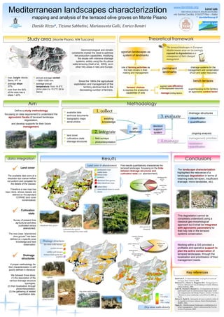
  • 1. low (1.4 m/ha) high (583.1 m/ha) •annual average rainfall: ~1000÷1300 mm, •averageannualtemperature: from 14.5°C (Arno plain) to 10.2°C (M.te Serra) Results Mediterranean landscapes characterization Land Lab Saint Anna School of Advanced Studies via Santa Cecilia, 3 56127 Pisa –Italia * davide@sssup.it Since the 1960s the agricultural exploitation and management of the territory declined due to the decreasing number of farmers. Study area (Monte Pisano, NW Tuscany) Geomorphological and climatic constraints implied the need to optimize the production capabilities, modifying the slopes with intensive drainage systems, widely using the dry-stone walls terracing (Galli et al., 2003), as in other hilly areas in Italy and Europe. •max. height: Monte Serra, 917 m •average slope37%; •over than the 80% of the area has a slope > 20% BaldeschiP., Il Chianti fiorentino, un progetto di tutela del paesaggio, Bari, Laterza, 2000. Brancucci G., Ghersi A., Ruggiero M.E., Paesaggi liguri a terrazze: riflessioni per una metodologia di studio, Firenze, Alinea Editrice, 2000. Galli M., Pieroni P., Brunori G.,«Un’esperienza di ricerca partecipativa per la valorizzazione degli spazi rurali nel comprensorio del Monte Pisano»,Estimo e territorio –Rivista di scienze ambientali, vol. LXVI, n°3, 2003: p. 54-63. Parvex F., Turiel A., Sauvegarde des murs en pierres sèches et du vignoble en terrasses valaisan,Sierre (Switzerland), SEREC, 2001. Ogrin D., «Mediterranean landscapes: contribution to a better management», Report commissioned by Priority Actions Programme, 2005. Key references permanent crops urban fabric other abandonedcrops semi-natural areas & woods abandonedolive groves rivers arable lands mixed crops pastures First results quantitatively characterize the terraced landscape, focussing on the linksbetweendrainagestructuresandcultivationstate(i.e. abandonment). Dry-stone walls density Define a studymethodology focussing on data requirement to understand the agronomicfacetsof terraced landscape degradation, and develop supports for their future management. Aim agrarian landscapes as system of landmarks role of farming activitiesas the main drivers in their making and management farmers’ choices to express the productive capabilities of soils managelimiting factors augment useefficiencyof the disposable resources permanent landmarks superimposing to the territory an agronomic controlfactor drainage systems for the management and conservation of soil and water resources bench terraces olive groves & vineyards abandoned olive groves ciglioni dry-stone walls terracesNdata integration Land cover  The available data were at a resolution too coarse neither not uniform and complete for the details of the classes. Therefore a new map has been done, whose classes are defined on the standard CORINE land cover nomenclature. Survey of present time agricultural activities (cultivated versus abandoned). The new class “abandoned olive groves” has been defined on a specific area knowledge and field observation. Cultivation state  A proper methodology for their characterization is still poorly defined in literature. We followed three steps: (1) the description of the various drainage structure typologies, (2) their localization through photointerpretation, (3) the gathering of related quantitative data. Drainage structures  Theoretical frameworkConclusions Working within a GIS provided a profitable and operative supporttoplantheactiveconservationof terraced landscapes, through the localization and prioritization of their management needs. This degradation cannot be completely understood using a classical geo-morphological approach but it shall be integratedwithagronomicparametersfor their key role in the terraced systems conservation. •available data •technical documents •topographic maps •aerial photos decision support system drainage structures management priorities (ongoing analysis) Methodology 1. collect 3. evaluate 4.manage 2. integrate geo database existing knowledge field surveys photointerpretation •land cover •cultivations state •drainage structures •localization •quantification •classification •quantification cultivated olive groves but unmanaged dry-stone walls dry-stone walls terraces terraces held-up by turf (ciglioni) pocket terraces rubble-wall terraces The terraced landscapes in European Mediterranean areas are increasingly exposed to degradationas a consequence of their changed management pocket terraces Drainage structures The landscapecharacterizationhighlighted the relevance of a landscapedegradationin terms of retaining walls fell-down, insufficient drainage, micro-landslides, etc). Land cover & abandonmentwww.land-lab.org mapping and analysis of the terraced olive groves on Monte Pisano Davide Rizzo*, Tiziana Sabbatini, Mariassunta Galli, Enrico Bonari