SlideShare uma empresa Scribd logo
1 de 15
INSAT-3D: migration from GEOSAR &
LEOSAR to MEOSAR
 SAS&R stands for satellite aided search and rescue
 It may be called as SARSAT(Search and rescue, satellite
aided tracking).
 The beginnings of SARSAT date back to October 1972.
 The SARSAT system was developed in a joint effort by
the United States, Canada , and France.
 In the United States, the SARSAT system was
developed by NASA.
 Once the system was functional, its operation was
turned over to NOAA where it remains today
1. Search and Rescue (SAR) instruments are flown on
Low Earth Orbiting (LEO) and Geostationary Orbiting
(GEO) satellites.
2. ELTs, EPIRBs, and PLBs operation.
3. Signals to LUTS
4. The LUT processes the data and transmits an alert
message to its respective Mission Control Center
(MCC)
5. The MCC performs matching and merging of alert
messages with other received messages
6. The RCC investigates the beacon alert and launches
assets to find the parties in distress when necessary.
1. Emergency Position Indicating Radio Beacon
(EPIRB)
2. Emergency Locator Transmitters (ELTs)
3. Personal Locator Beacons (PLBs)
 INSAT-3D
 GSAT-7
 GSAT-10
 INSAT-3A
 KALPNA
 6 channel multi-spectral Imager
 Outgoing Long wave Radiation (OLR)
 Quantitative Precipitation Estimate (QPE)
 Atmospheric Motion Vector (AMV)
 Upper Troposphere Humidity (UTH)
 Sea Surface Temperature (SST)
 Land Surface Temperature (LST)
 Water Vapor Wind Vector
 19 channel Sounder
 Data Relay Transponder (DRT)
 Search and Rescue Transponder
SOUNDER
 Temperature, Humidity profiles and Integrated Ozone
 Geo-potential Height (GH)
 Layer Precipitable Water
 Total Precipitable Water
 Lifted Index (LI)
 Wind Index (WI)
 Dry Microburst Index (DMI)
 Potential Temperature Dierential
 Ozone estimate
 GEOSAR systems provide location information only if
this information is available from an external source (i.e.
global navigation receiver in the beacon) and
transmitted in the 406 MHz beacon message;
 obstructions blocking the beacon to satellite link cannot
be overcome because the satellite is stationary with
respect to the beacon; and
 the beacon to satellite to LUT communication link
budget is less robust than the LEOSAR system because
of the greater distances involved (decreasing the
probability that 406 MHz beacon messages are properly
detected by the GEOSAR system).
 12 Ku-band transponders each with 36 Mhz usable
bandwidth employing 140 W Travelling Wave Tube
Amplifier (TWTA) with footprint covering Indian
mainland with an Edge of Coverage Effective Isotropic
Radiated Power (EIRP) of 51.5 dBW and Andaman &
Nicobar islands with an EIRP of 49.5 dBW
 12 C-band transponders each with 36 MHz usable
bandwidth employing 32 W TWTA with footprint
covering Indian mainland and West Asia with an Edge
of Coverage EIRO of 40 dBW
 6 Lower Extended C-band transponders each with 36
MHz usable bandwidth employing 32 W TWTA with
footprint covering Indian mainland and island territories
with an Edge of Coverage EIRP of 38 dBW and 37
 Two-channel GAGAN payload operating in L1 and
L5 bands provides Satellite-based Navigation
services with accuracy and integrity required for
civil aviation applications over Indian Air Space.
 Initial investigations identified many possible SAR
alerting benefits that might be realized from a
MEOSAR system, including
 near instantaneous global coverage with accurate
independent location capability,
 robust beacon to satellite communication links, high
levels of satellite redundancy and availability,
 resilience against beacon to satellite obstructions, and
 the possible provision for additional (enhanced) SAR
services, such as a ground to beacon return link.
 Cospas-Sarsat is an international satellite system for
search and rescue (SAR) distress alerting that was
established in 1979 by Canada, France, the USA and the
former USSR
 43 countries and organizations share in the management
of the System.
 At the end of 2009, more than 28,000 people had been
rescued through the use of the System.
 Because of LEOSAR satellite orbit patterns, there can
be delays between beacon activation and the generation
of an alert message.
 So we will move on the MEOSAR for fast and furious
action.
Satellite aided search and rescue,

Mais conteúdo relacionado

Mais procurados

Recent trends in satellite communication
Recent trends in satellite communicationRecent trends in satellite communication
Recent trends in satellite communication
Suriya Prakash
 
Introduction to gps and gnss
Introduction to gps and gnssIntroduction to gps and gnss
Introduction to gps and gnss
Vivek Srivastava
 
Indian satellite based navigation system description and implementation status
Indian satellite based navigation system description and implementation statusIndian satellite based navigation system description and implementation status
Indian satellite based navigation system description and implementation status
huangxj73
 
Satellite communication
Satellite communicationSatellite communication
Satellite communication
Needa Multani
 

Mais procurados (20)

ORBCOMM Satellite System
ORBCOMM Satellite SystemORBCOMM Satellite System
ORBCOMM Satellite System
 
Satellite Sys
Satellite SysSatellite Sys
Satellite Sys
 
Satellite Communication
Satellite CommunicationSatellite Communication
Satellite Communication
 
Recent trends in satellite communication
Recent trends in satellite communicationRecent trends in satellite communication
Recent trends in satellite communication
 
Satellite communication Basics
Satellite communication BasicsSatellite communication Basics
Satellite communication Basics
 
Introduction to gps and gnss
Introduction to gps and gnssIntroduction to gps and gnss
Introduction to gps and gnss
 
Microwave & satellites
Microwave & satellitesMicrowave & satellites
Microwave & satellites
 
Final Lecture Enav211
Final Lecture Enav211Final Lecture Enav211
Final Lecture Enav211
 
Intd to Sat Commn
Intd to Sat CommnIntd to Sat Commn
Intd to Sat Commn
 
Cospas day 12
Cospas day 12Cospas day 12
Cospas day 12
 
Satellite communication
Satellite communicationSatellite communication
Satellite communication
 
Abstract IRNSS Architecture and Applications
Abstract  IRNSS Architecture and ApplicationsAbstract  IRNSS Architecture and Applications
Abstract IRNSS Architecture and Applications
 
Satellite Communication Theory
Satellite  Communication TheorySatellite  Communication Theory
Satellite Communication Theory
 
Mobile satellite communication
Mobile satellite communicationMobile satellite communication
Mobile satellite communication
 
Indian satellite based navigation system description and implementation status
Indian satellite based navigation system description and implementation statusIndian satellite based navigation system description and implementation status
Indian satellite based navigation system description and implementation status
 
Satellite communication
Satellite communicationSatellite communication
Satellite communication
 
Satellite communication
Satellite communicationSatellite communication
Satellite communication
 
Satellite communication
Satellite communicationSatellite communication
Satellite communication
 
PRESENTATION ON SATELLITE COMMUNICATION
PRESENTATION ON SATELLITE COMMUNICATIONPRESENTATION ON SATELLITE COMMUNICATION
PRESENTATION ON SATELLITE COMMUNICATION
 
PPT ON IRIDIUM SATELLITE (ECE)
PPT ON IRIDIUM SATELLITE (ECE)PPT ON IRIDIUM SATELLITE (ECE)
PPT ON IRIDIUM SATELLITE (ECE)
 

Destaque (6)

RESCUE ROBOT
RESCUE ROBOTRESCUE ROBOT
RESCUE ROBOT
 
Surveillance and Rescue Robot using Android Smartphone and the Internet
Surveillance and Rescue Robot using Android Smartphone and the InternetSurveillance and Rescue Robot using Android Smartphone and the Internet
Surveillance and Rescue Robot using Android Smartphone and the Internet
 
Rescue Robots
Rescue RobotsRescue Robots
Rescue Robots
 
human detection robot
human detection robothuman detection robot
human detection robot
 
Search and rescue
Search and rescueSearch and rescue
Search and rescue
 
Build Features, Not Apps
Build Features, Not AppsBuild Features, Not Apps
Build Features, Not Apps
 

Semelhante a Satellite aided search and rescue,

1 IGARSS 2011 JPSS Monday Goldberg.pptx
1 IGARSS 2011 JPSS Monday Goldberg.pptx1 IGARSS 2011 JPSS Monday Goldberg.pptx
1 IGARSS 2011 JPSS Monday Goldberg.pptx
grssieee
 
Gps systems m. emin özgünsür
Gps systems   m. emin özgünsürGps systems   m. emin özgünsür
Gps systems m. emin özgünsür
emin_oz
 
Ubp electronics in defence
Ubp electronics  in defenceUbp electronics  in defence
Ubp electronics in defence
Ritesh Kalshetty
 
Satellite communication bani
Satellite communication baniSatellite communication bani
Satellite communication bani
Sarah Krystelle
 

Semelhante a Satellite aided search and rescue, (20)

Topic for Midterm
Topic for Midterm Topic for Midterm
Topic for Midterm
 
satellite communication notes for anna university
satellite communication notes for anna universitysatellite communication notes for anna university
satellite communication notes for anna university
 
Latest Advances in GPS technology Seminar report
Latest Advances in GPS technology Seminar reportLatest Advances in GPS technology Seminar report
Latest Advances in GPS technology Seminar report
 
ongc satellite communication
 ongc satellite communication ongc satellite communication
ongc satellite communication
 
1 IGARSS 2011 JPSS Monday Goldberg.pptx
1 IGARSS 2011 JPSS Monday Goldberg.pptx1 IGARSS 2011 JPSS Monday Goldberg.pptx
1 IGARSS 2011 JPSS Monday Goldberg.pptx
 
In sar 1-1-2011
In sar 1-1-2011In sar 1-1-2011
In sar 1-1-2011
 
Iridium Satellite Communications System, Tsunami Warning System
Iridium Satellite Communications System, Tsunami Warning SystemIridium Satellite Communications System, Tsunami Warning System
Iridium Satellite Communications System, Tsunami Warning System
 
satellite communication system
satellite communication system satellite communication system
satellite communication system
 
MODIS (Moderate Resolution Imaging Spectrometer)
MODIS (Moderate Resolution Imaging Spectrometer)MODIS (Moderate Resolution Imaging Spectrometer)
MODIS (Moderate Resolution Imaging Spectrometer)
 
Gps systems m. emin özgünsür
Gps systems   m. emin özgünsürGps systems   m. emin özgünsür
Gps systems m. emin özgünsür
 
Navic india's own navigation system
Navic india's own navigation systemNavic india's own navigation system
Navic india's own navigation system
 
Different GNSS (Global Navigation Satellite System) Receiver’s combination an...
Different GNSS (Global Navigation Satellite System) Receiver’s combination an...Different GNSS (Global Navigation Satellite System) Receiver’s combination an...
Different GNSS (Global Navigation Satellite System) Receiver’s combination an...
 
Radar
RadarRadar
Radar
 
Ubp electronics in defence
Ubp electronics  in defenceUbp electronics  in defence
Ubp electronics in defence
 
Setellite image sensors
Setellite image sensorsSetellite image sensors
Setellite image sensors
 
Satellite communication bani
Satellite communication baniSatellite communication bani
Satellite communication bani
 
bout NISAR.pptx
bout NISAR.pptxbout NISAR.pptx
bout NISAR.pptx
 
R adar
R adarR adar
R adar
 
Geo imaging satellite
Geo imaging satelliteGeo imaging satellite
Geo imaging satellite
 
Geo Stationary Earth Orbit imaging satellite
Geo Stationary Earth Orbit imaging satelliteGeo Stationary Earth Orbit imaging satellite
Geo Stationary Earth Orbit imaging satellite
 

Último

+971581248768>> SAFE AND ORIGINAL ABORTION PILLS FOR SALE IN DUBAI AND ABUDHA...
+971581248768>> SAFE AND ORIGINAL ABORTION PILLS FOR SALE IN DUBAI AND ABUDHA...+971581248768>> SAFE AND ORIGINAL ABORTION PILLS FOR SALE IN DUBAI AND ABUDHA...
+971581248768>> SAFE AND ORIGINAL ABORTION PILLS FOR SALE IN DUBAI AND ABUDHA...
?#DUbAI#??##{{(☎️+971_581248768%)**%*]'#abortion pills for sale in dubai@
 

Último (20)

Powerful Google developer tools for immediate impact! (2023-24 C)
Powerful Google developer tools for immediate impact! (2023-24 C)Powerful Google developer tools for immediate impact! (2023-24 C)
Powerful Google developer tools for immediate impact! (2023-24 C)
 
Automating Google Workspace (GWS) & more with Apps Script
Automating Google Workspace (GWS) & more with Apps ScriptAutomating Google Workspace (GWS) & more with Apps Script
Automating Google Workspace (GWS) & more with Apps Script
 
Advantages of Hiring UIUX Design Service Providers for Your Business
Advantages of Hiring UIUX Design Service Providers for Your BusinessAdvantages of Hiring UIUX Design Service Providers for Your Business
Advantages of Hiring UIUX Design Service Providers for Your Business
 
A Domino Admins Adventures (Engage 2024)
A Domino Admins Adventures (Engage 2024)A Domino Admins Adventures (Engage 2024)
A Domino Admins Adventures (Engage 2024)
 
Mastering MySQL Database Architecture: Deep Dive into MySQL Shell and MySQL R...
Mastering MySQL Database Architecture: Deep Dive into MySQL Shell and MySQL R...Mastering MySQL Database Architecture: Deep Dive into MySQL Shell and MySQL R...
Mastering MySQL Database Architecture: Deep Dive into MySQL Shell and MySQL R...
 
Exploring the Future Potential of AI-Enabled Smartphone Processors
Exploring the Future Potential of AI-Enabled Smartphone ProcessorsExploring the Future Potential of AI-Enabled Smartphone Processors
Exploring the Future Potential of AI-Enabled Smartphone Processors
 
Axa Assurance Maroc - Insurer Innovation Award 2024
Axa Assurance Maroc - Insurer Innovation Award 2024Axa Assurance Maroc - Insurer Innovation Award 2024
Axa Assurance Maroc - Insurer Innovation Award 2024
 
Strategies for Landing an Oracle DBA Job as a Fresher
Strategies for Landing an Oracle DBA Job as a FresherStrategies for Landing an Oracle DBA Job as a Fresher
Strategies for Landing an Oracle DBA Job as a Fresher
 
+971581248768>> SAFE AND ORIGINAL ABORTION PILLS FOR SALE IN DUBAI AND ABUDHA...
+971581248768>> SAFE AND ORIGINAL ABORTION PILLS FOR SALE IN DUBAI AND ABUDHA...+971581248768>> SAFE AND ORIGINAL ABORTION PILLS FOR SALE IN DUBAI AND ABUDHA...
+971581248768>> SAFE AND ORIGINAL ABORTION PILLS FOR SALE IN DUBAI AND ABUDHA...
 
Partners Life - Insurer Innovation Award 2024
Partners Life - Insurer Innovation Award 2024Partners Life - Insurer Innovation Award 2024
Partners Life - Insurer Innovation Award 2024
 
Strategies for Unlocking Knowledge Management in Microsoft 365 in the Copilot...
Strategies for Unlocking Knowledge Management in Microsoft 365 in the Copilot...Strategies for Unlocking Knowledge Management in Microsoft 365 in the Copilot...
Strategies for Unlocking Knowledge Management in Microsoft 365 in the Copilot...
 
A Year of the Servo Reboot: Where Are We Now?
A Year of the Servo Reboot: Where Are We Now?A Year of the Servo Reboot: Where Are We Now?
A Year of the Servo Reboot: Where Are We Now?
 
Workshop - Best of Both Worlds_ Combine KG and Vector search for enhanced R...
Workshop - Best of Both Worlds_ Combine  KG and Vector search for  enhanced R...Workshop - Best of Both Worlds_ Combine  KG and Vector search for  enhanced R...
Workshop - Best of Both Worlds_ Combine KG and Vector search for enhanced R...
 
Connector Corner: Accelerate revenue generation using UiPath API-centric busi...
Connector Corner: Accelerate revenue generation using UiPath API-centric busi...Connector Corner: Accelerate revenue generation using UiPath API-centric busi...
Connector Corner: Accelerate revenue generation using UiPath API-centric busi...
 
TrustArc Webinar - Stay Ahead of US State Data Privacy Law Developments
TrustArc Webinar - Stay Ahead of US State Data Privacy Law DevelopmentsTrustArc Webinar - Stay Ahead of US State Data Privacy Law Developments
TrustArc Webinar - Stay Ahead of US State Data Privacy Law Developments
 
Data Cloud, More than a CDP by Matt Robison
Data Cloud, More than a CDP by Matt RobisonData Cloud, More than a CDP by Matt Robison
Data Cloud, More than a CDP by Matt Robison
 
Real Time Object Detection Using Open CV
Real Time Object Detection Using Open CVReal Time Object Detection Using Open CV
Real Time Object Detection Using Open CV
 
TrustArc Webinar - Unlock the Power of AI-Driven Data Discovery
TrustArc Webinar - Unlock the Power of AI-Driven Data DiscoveryTrustArc Webinar - Unlock the Power of AI-Driven Data Discovery
TrustArc Webinar - Unlock the Power of AI-Driven Data Discovery
 
ProductAnonymous-April2024-WinProductDiscovery-MelissaKlemke
ProductAnonymous-April2024-WinProductDiscovery-MelissaKlemkeProductAnonymous-April2024-WinProductDiscovery-MelissaKlemke
ProductAnonymous-April2024-WinProductDiscovery-MelissaKlemke
 
The 7 Things I Know About Cyber Security After 25 Years | April 2024
The 7 Things I Know About Cyber Security After 25 Years | April 2024The 7 Things I Know About Cyber Security After 25 Years | April 2024
The 7 Things I Know About Cyber Security After 25 Years | April 2024
 

Satellite aided search and rescue,

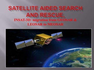
  • 1. INSAT-3D: migration from GEOSAR & LEOSAR to MEOSAR
  • 2.  SAS&R stands for satellite aided search and rescue  It may be called as SARSAT(Search and rescue, satellite aided tracking).  The beginnings of SARSAT date back to October 1972.  The SARSAT system was developed in a joint effort by the United States, Canada , and France.  In the United States, the SARSAT system was developed by NASA.  Once the system was functional, its operation was turned over to NOAA where it remains today
  • 3. 1. Search and Rescue (SAR) instruments are flown on Low Earth Orbiting (LEO) and Geostationary Orbiting (GEO) satellites. 2. ELTs, EPIRBs, and PLBs operation. 3. Signals to LUTS 4. The LUT processes the data and transmits an alert message to its respective Mission Control Center (MCC) 5. The MCC performs matching and merging of alert messages with other received messages 6. The RCC investigates the beacon alert and launches assets to find the parties in distress when necessary.
  • 4.
  • 5. 1. Emergency Position Indicating Radio Beacon (EPIRB) 2. Emergency Locator Transmitters (ELTs) 3. Personal Locator Beacons (PLBs)
  • 6.  INSAT-3D  GSAT-7  GSAT-10  INSAT-3A  KALPNA
  • 7.  6 channel multi-spectral Imager  Outgoing Long wave Radiation (OLR)  Quantitative Precipitation Estimate (QPE)  Atmospheric Motion Vector (AMV)  Upper Troposphere Humidity (UTH)  Sea Surface Temperature (SST)  Land Surface Temperature (LST)  Water Vapor Wind Vector  19 channel Sounder  Data Relay Transponder (DRT)  Search and Rescue Transponder
  • 8. SOUNDER  Temperature, Humidity profiles and Integrated Ozone  Geo-potential Height (GH)  Layer Precipitable Water  Total Precipitable Water  Lifted Index (LI)  Wind Index (WI)  Dry Microburst Index (DMI)  Potential Temperature Dierential  Ozone estimate
  • 9.  GEOSAR systems provide location information only if this information is available from an external source (i.e. global navigation receiver in the beacon) and transmitted in the 406 MHz beacon message;  obstructions blocking the beacon to satellite link cannot be overcome because the satellite is stationary with respect to the beacon; and  the beacon to satellite to LUT communication link budget is less robust than the LEOSAR system because of the greater distances involved (decreasing the probability that 406 MHz beacon messages are properly detected by the GEOSAR system).
  • 10.  12 Ku-band transponders each with 36 Mhz usable bandwidth employing 140 W Travelling Wave Tube Amplifier (TWTA) with footprint covering Indian mainland with an Edge of Coverage Effective Isotropic Radiated Power (EIRP) of 51.5 dBW and Andaman & Nicobar islands with an EIRP of 49.5 dBW  12 C-band transponders each with 36 MHz usable bandwidth employing 32 W TWTA with footprint covering Indian mainland and West Asia with an Edge of Coverage EIRO of 40 dBW  6 Lower Extended C-band transponders each with 36 MHz usable bandwidth employing 32 W TWTA with footprint covering Indian mainland and island territories with an Edge of Coverage EIRP of 38 dBW and 37
  • 11.  Two-channel GAGAN payload operating in L1 and L5 bands provides Satellite-based Navigation services with accuracy and integrity required for civil aviation applications over Indian Air Space.
  • 12.  Initial investigations identified many possible SAR alerting benefits that might be realized from a MEOSAR system, including  near instantaneous global coverage with accurate independent location capability,  robust beacon to satellite communication links, high levels of satellite redundancy and availability,  resilience against beacon to satellite obstructions, and  the possible provision for additional (enhanced) SAR services, such as a ground to beacon return link.
  • 13.  Cospas-Sarsat is an international satellite system for search and rescue (SAR) distress alerting that was established in 1979 by Canada, France, the USA and the former USSR  43 countries and organizations share in the management of the System.  At the end of 2009, more than 28,000 people had been rescued through the use of the System.  Because of LEOSAR satellite orbit patterns, there can be delays between beacon activation and the generation of an alert message.  So we will move on the MEOSAR for fast and furious action.