![Vector Addition to Coarsen Pixels Resultant Vector (a+b+c+d) = ,[object Object],[object Object],[object Object],[object Object],[object Object],2 30 m 120 m 480 m 1920 m 30720 m 7680 m Scatter Plots : X Axis: ArcGIS Aspect Values Y Axis: Idrisi Aspect Values X ranges from 0 to 360 degrees & Y ranges from 0 to 360 degrees Applying Slope Weightage O n the left, the Idrisi pixel is facing West with a slope of 1 0 and the ArcGIS pixel is facing East with a slope of 2 0 , on the right, the Idrisi pixel is facing West with a slope of 45 0 and the ArcGIS pixel is facing East with a slope of 70 0 . The pixel values on the right will be more important than that to the left. Slope acts as magnitude in vector addition for coarsening the pixels. Circular Variable : More than one ways of reaching between A & B Aspect is a Circular Variable I f the value of a pixel in Idrisi map is 350 0 (A) and the value of a pixel in ArcGIS map is 10 0 (B) then the difference between the two pixels can be both 340 0 (Anticlockwise) and 20 0 (Clockwise). We used the least difference (20 0 ) : X n = Value of a pixel in ArcGIS aspect map Y n = Value of a pixel in Idrisi aspect map in D n = Least difference in angle between X n and Y n If X n – Y n <= 180 Then D n = X n – Y n Else D n = 360 – (X n – Y n ) EndIf Sin θ a + Sin θ b + Sin θ c + Sin θ d Tan -1 Cos θ a + Cos θ b + Cos θ c + Cos θ d](data:image/gif;base64,R0lGODlhAQABAIAAAAAAAP///yH5BAEAAAAALAAAAAABAAEAAAIBRAA7)
Recomendados
Recomendados
Mais conteúdo relacionado
Mais procurados
Mais procurados (17)
Destaque
Semelhante a Comparing directions
Semelhante a Comparing directions (20)
Mais de Rahul Rakshit
Último
Último (20)
Comparing directions
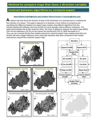
- 1. A n aspect map that shows the direction of slope of the landscape is an essential input in modeling the flow direction of a stream. This paper’s objective is to illustrate a novel method of comparing and quantifying the difference between two aspect maps created using different algorithms from two industry leading GIS softwares Idrisi and ArcGIS but same elevation data at different resolutions. The paper demonstrates that at high resolution (30m), the mean of difference between the aspect maps (MDA) from the two softwares is 25 0 but as we coarsen the resolution(30,720 m), MDA decreases to 3 0 . Thus, we can conclude that the flow models produced by using the aspect maps created using Idrisi and ArcGIS will show a bigger difference when using high resolution data when compared to flow models produced by using the low resolution aspect maps. 1 Elevation Aspect ArcGIS Slope Idrisi Slope ArcGIS Aspect Idrisi Sin ArcGIS Cos ArcGIS Sin Idrisi Cos Idrisi Coarser Aspect ArcGIS Coarser Aspect Idrisi Scatter Plots (Coarse) Scatter Plot (Fine)