Beginners Guide to TikTok for Search - Rachel Pearson - We are Tilt __ Bright...
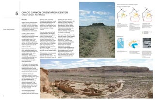
Chaco Canyon
1. WORLD HERITAGE SITES PRECEDENT STUDIES
Giza Plateau Site Management Analysis
Alexandria Alexandria Alexandria
Cairo Cairo Cairo
CHACO CANYON ORIENTATION CENTER
5 Chaco Canyon, New Mexico
Program Anasazi world, a journey existing dirt roads around
through time that would reveal Chaco Canyon depends on the Fayoum Fayoum Fayoum
Chaco Canyon was the heart the essential elements of the interplay of many agencies
I. Prior Condition II. Overall Access III. Visitor experience + Excavation
of Anasazi Culture between Anasazi belief systems, a such as the Bureau of Land Access to monuments via internal road system Conservation Zone established within World Un-authentic structures removed
850 and 1250 AD. As a center sequence of experiences that Management, Navajo Nation, Most visitors stay for 90 minutes with stops at
the Sphinx and the Great Pyramid
Heritage Site
Internal road system replaced by one-way
Educational/conservational structures built
Further excavation within Conservation Zone
for trade and ceremony, Chaco would make the visitors aware and the National Park Service. Lack of visitor management and education leads
to on-site damage
perimeter access road
Parking located at three new reception centers
GIS mapping for site assessment
Staff training to provide knowledgable
is remarkable for its distinctive of the elements of Chaco Taking into consideration the Pyramids closed sequentially for maintenance
New sites opened to distribute visitors over the
personnel
whole site
Critic: Glenn Murcutt cosmologically planned Culture. many factors involved in Entrance fee charged to decrease foot traffic
and fund maintenance
architecture and road system. Chaco's planning, a sequence Conservation zone
Educational/conservation structures
From our talks with the Park of phases is proposed. Internal road system
Pyramid complexes
In 1907, Chaco Canyon Superintendent, we learned Reception Centers
Unauthentic structures
National Monument was that the greatest issue facing The heart of the plan lies in the
created to preserve the largest Chaco is infrastructure. first two phases. These phases Ninstints Approach
collection of prehistoric Currently, the infrastructure of are designed to connect the
archaeological sites in the the park detracts from the journey to the Chaco
United States. Today the interpretive potential of Chaco. experience, systematically
canyon remains a significant The Chaco Plan Comparison preserve archaeological sites,
sacred site to many Southwest (pg 3) shows how a proposed remove obstructions that
Indian Cultures such as the plan would improve and detract from the visitor's
Hopi and Navajo. change the present condition experience, and foster
of Chaco. The Site vehicular movement along the
Unfortunately, the Chacoan Management Plan components periphery of the site. The last
ruins face great danger from are then further detailed (pg 4). two phases work to enhance I. Journey to Sacred Haida Site II. Overall Access III. Visitor experience + Excavation
The journey to the Haida settlement is part of Advance reservations with Haida guardians The isolation of the site, and necessity of
exposure to the elements and the visitor's experience by the Ninstints experience must be made before visiting site arriving by sea as its original inhabitants did,
Access to site via kayak at high tide makes a profound impression on visitors
tourist impacts (e.g., ruins The execution of the proposed offering more options to hikers Guided tours of site given by Haida guardians 1995 Parks Canada/Haida team excavated
and straightened 4 totem poles
desecration, artifact Site Management Plan and distributing the impact of No visitor centers or signs on the island
Motorized vehicular access is prohibited
scavenging). The interest in depends on many factors. For visitors around the site more
Approach
uncovering, excavating, and example, the issue of reuse of evenly. Ninstints site and totem poles
accessing the ruins has
paradoxically accelerated
their deterioration.
The focus of this studio project
is the design of a strategic plan
and orientation center that
address the present critical
interpretation and preservation
issues facing Chaco Canyon.
In order to develop an
orientation center for Chaco,
other World Heritage sites such
as the Pyramids of Giza and
the Haida settlement of
Ninstints were analyzed as
relevant precedents. The
objective of these precedent
analyses was to learn how an
interpretive center could tell
the story of a site.
The interpretive strategy
envisioned for Chaco is a
transition from our world to the
1
2. CHACO PARK PLANNING CHACO PARK PLANNING
PLAN ANALYSIS SITE MANAGEMENT PLAN
PRESENT PLAN NATIONAL PARK SERVICE PROGRAM
0 1 MILE
The goal of the National Park Service (NPS) is to manage the preservation and
Farmington interpretation of the Chaco Culture National Park. The interpretive strategy
proposed is a journey that would reveal the Anasazi belief system; a sequence
of experiences that would make the visitors aware of the key elements of Chaco
culture.
The program of the NPS is arranged to support the interpretive strategy. A
conservation zone is defined by a new loop road. All unauthentic modern
structures such as housing, maintenance facilities, and visitor center are moved
to the exterior of this zone. The visitor center is located along original Chacoan
road passing through South Gap thereby integrating the journey to the Chaco
experience. The campground is re-located to a discreet site past the visitor
center along the loop road to ensure all campers register before camping.
A landscape system is established to preserve archaeological sites. Modular
preservation mounds cover unexcavated sites and allow for future piecemeal
excavation.
Camping Visitor Center / Gate
Housing Preservation Mound
Maintenance Sheds
HIKING TRAIL SYSTEM
The goal of the proposed hiking trail system is to enhance visitors' experiences
and to distribute visitors more evenly over the park. All shuttle bus revenue goes
toward the maintenance of the park.
To enhance visitor's appreciation of Chaco sites, the trails are designed to reveal
the logic of Anasazi alignments and building siting.
The trail system is integrated with the park loop road and shuttle bus system to
enhance visitor's experiences by offering more options for trails; one way or
round trip journeys, sunset experiences within the park, and access to remote
areas of the park.
Thoreau Two types of trails are proposed: (a) circuit trails are localized trails, shorter in
distance, that focus on particular aspects of the park, (b) traverse trails are
choreographed to reveal the drama of the journey through Chaco Canyon.
North South Access Road
Internal Loop Road
Visitor Center Circuit Trails Traverse Trails
Camping
Housing
Maintenance Sheds
I. Vehicular Traffic Routes II. Unauthentic Structures III. Inhabitation
VEHICULAR TRAFFIC ROUTES
Access to loop road is neither gated nor monitored. Subsequent lack of visitor Unauthentic structures (such as bathrooms and the visitor center), and signage Camping and housing structures located in front of visitor center along the The vehicular traffic infrastructure addresses issues concerning control,
management and education leads to on-site damage. Access to monuments via within park obstruct Anasazi alignments. northern entry detract from the grandeur of the world heritage site. Campers entry, access, and maintenance. Three types of roads are articulated:
paved internal road system has no relationship to Chacoan inter-building may camp without proper registration. north south access route, perimeter loop road, and maintenance roads.
alignments. Visitors drive through the canyon past most other archeological
sites to get to main attraction, Pueblo Bonito. Car routes and parking next to The north south access route connects Chaco National Park to the outside
sensitive archaeological sites detract from the Chaco experience. world. Fajada Butte serves as the entrance beacon for Chaco Canyon
along the route. The North South access road is routed east of Fajada Butte
to maintain distance from the Una Vida site.
PROPOSED PLAN The internal road system is replaced by a perimeter loop road approximately
25 miles in length which first directs all visitors through the gate / visitor center.
The loop road incorporates many existing dirt roads through Chaco
0 1 MILE
Canyon. All parking is located outside the internal loop road
Farmington
Maintenance roads provide access for maintenance and archaeological work
and also act as alignment foot paths
Farmington
North South Access Roads Fajada Butte
Two Way Perimeter Road Visitor Center / Gate
One Way Perimeter Road Pueblo Benasco Stop Thoreau
Pueblo Alto Stop
Maintenance Road /
Anasazi Road Systems Una Vida Stop
B.
C.
D.
A.
INTEGRATED SITE MANAGEMENT PLAN
The implementation of the site management plan works to preserve Historic
Chaco Culture Sites and provide for their interpretation. The overlay of
National Park Service program, hiking trail system, and vehicular traffic
infrastructure is designed to enhance visitor experience and understanding of
the site.
North South Access Roads Fajada Butte
Two Way Perimeter Road Visitor Center / Gate
One Way Perimeter Road Pueblo Benasco Stop
Pueblo Alto Stop
Maintenance Road /
Anasazi Road Systems Una Vida Stop
Camping Preservation Mound
Thoreau Housing Traverse Trails
Maintenance Sheds Circuit Trails
I. Perimeter Access Road / Internal Conservation Zone II. New Hiking Modes Pueblo Benasco Stop North South Access Road
The site strategy proposed for Chaco is similar to the strategy currently Circuit and traverse trails coupled to the proposed shuttle bus system offer new Pueblo Alto Stop Two Way Perimeter Road
deployed at the Pyramids of Giza. Limiting vehicular access to the ways to use Chaco Culture Park. Una Vida Stop One Way Perimeter Road
periphery allows for: the establishment of a controlled internal
conservation zone, more authentic experiences with the ancient ruins A. Hike circuit trail from visitor center Camping Maintenance Roads
for the visitors, and different hiking experiences for visitors. B. Drive to bus stop and hike circuit trail
Housing Visitor Center
C. Hike from visitor center to bus stop
D. Hike from bus stop to bus stop
3 4
3. CHACO PARK PLANNING
TRANSFORMATION
2002
P
I
H Farmington
A
S
E The goals of this phase are to systematically preserve and
Thoreau
protect archaeological sites and enhance visitor experience II
through landscape modification.
I Earthwork preservation mounds
Maintenance roads / alignment paths
Excavation at proposed visitor center site
2005
P
H Farmington
III
Great Houses
A Indian Ruins
Summer solstice sunset Summer solstice sunrise
Geographical Landmarks
Anasazi Road System
S
Building to Building
Winter solstice sunset Winter solstice sunrise Building to Geographical Landmark
E
Thoreau
The new visitor center is constructed after careful excavation
and survey of its site. All unauthentic structures within the
park are removed to enhance visitor experience.
II New South Gap visitor center I. ANASAZI ROAD SYSTEM II. BUILDING TO GEOGRAPHICAL LANDMARK III. SOLSTICE DIAGRAM
Removal of old visitor center BUILDING TO BUILDING
Removal of paved roads and parking lots
P
2010
PHASE I: LANDSCAPE + PRESERVATION
OVERVIEW
H Farmington
The main objective of this macroscopic scale, Pueblo Chaco impedes the visitor's axis alignments at Tsin Kletsin,
A phase is to design the Bonito is aligned to Pueblo Alto holistic understanding of Chaco. Pueblo Alto) at various ruins,
landscape of Chaco to present and Tsin Kletsin along its For example, obtrusive parking the visitor learns how the
S the ruins as part of an cardinal north-south axis. lots, signage, and roads ruins are interconnected to
interconnected web of sites The ancient North Road that interfere with Chaco other buildings and
instead of isolated objects in connects Chaco to Aztec Ruins alignments. geographical landmarks.
E
the landscape. 65 miles north of the site runs
Thoreau
straight along this axis from By changing the design of The first part of this phase
The goal of this phase is to distribute the impacts of visitors
throughout the site by offering different types of hikes through The Anasazi designed their Pueblo Alto. At the microscopic Chaco's infrastructure, the connects ruins to each other
III the canyon.
Shuttle bus on existing dirt road between
buildings to connect to their scale, a kiva and ridge of visitor can understand how the via dirt maintenance roads.
new visitor center and Pueblo Alto stop
cosmos and natural narrow rooms within Pueblo ruins connect to their This allows the Park service to
surroundings in various ways: Bonito's plaza are aligned to landscape and other ruins. periodically maintain sites and
P 2015 siting, materials, form, and the north-south axis. At the Secondly, by adding pertinent visitors to walk from ruin to
alignment. An 'alignment' was midpoint of everyday, the sun infrastructure for interpretation, ruin. Currently, there are no
made when a building is placed is directly in line with Pueblo the visitor can develop a new direct footpaths between ruins.
H on axis with a geographical Bonito's kiva and ridge, the understanding of Chaco. For The proposed paths would be
Farmington
landmark, road, celestial event North Road, and the ruins instance, instead of walking by created just as the ancient
A (i.e., solstice sunrise location (Pueblo Bonito, Pueblo Alto, 'holes in the ground' (kivas) roads were established. A
on horizon), or another building. and Tsin Kletsin). The logic of within building sites, a visitor simple turning of soil and its
S The diagram above shows a Anasazi alignments is can understand that the aligned resulting change in soil
map of Chaco overlaid with a remarkably consistent at both kivas define the building's content would change/inhibit
E map of Anasazi alignments. large and small scales and relationship to cosmological the surface vegetation, thus
underlies Anasazi planning and events and to other buildings in marking the pathway.
Thoreau
At crucial ruins such as Pueblo architecture. the canyon. Finally, by
The goal of this phase is to offer opportunities to hike to
remote scenic areas and archaeological sites of Chaco Bonito, there are multiple experiencing similar kiva
IV canyon.
overlapping alignments. At the Currently, the infrastructure of alignments (i.e., north-south
New seasonal dirt road between new
visitor center and Pueblo Benasco stop
5 6
4. PHASE I: LANDSCAPE + PRESERVATION
KIVA PATHWAYS
Once at a ruin, a simple wooden
plank pathway encourages
visitors to visit ruins without
stepping on fragile walls. The
pathway strategy developed for
Chaco ruins highlights the
Anasazi's cosmological
alignments and relationships by
positioning platforms in line with
kiva alignments. These places
of rest are connected by
wooden plank paths. As
mentioned before, kiva
alignments are important
because they are aligned to the
solar and lunar events which
serve as the basis of all Anasazi
site planning.
The sketches (below left) show
how different sites such as
Chetro Ketl, Pueblo Arroyo, and
Una Vida share cosmological
characteristics that are unique
to Chaco architecture; kivas are
aligned to celestial events
(i.e., winter solstice sunrise).
A prototypical pathway for
Pueblo Bonito highlighting
solstice, cardinal, equinox, and
lunar events is proposed (below
right).
Path
Cardinal Platform
Lunar Minor Platform
Lunar Major Platform
Solstice Platform
7 8
5. A
PHASE I: LANDSCAPE + PRESERVATION
PRESERVATION MOUNDS
Visitors of Chaco ruins are often
unaware of the extent of
archaeological remains and
artifacts. The ruins which are
visible and visited comprise only
A'
a fraction of the archaeological
record. In fact, a trove of
valuable archaeological
information lies beneath the
ground that the visitors walk on.
The series of sections of Pueblo
Bonito on the right details
former and proposed modes of
land use around the ruins.
PRE-EXCAVATION: 1890
Prior to 1900's, the trash
middens located south of
Pueblo Bonito contained
thousands of artifacts.
During the 1920's, archaeologist
Neil Judd excavated trenches
through these middens in
search of artifacts to piece
together a picture of the culture
that once occupied Chaco.
JUDD EXCAVATION: 1920
In its current condition,
thousands of visitors
unknowingly walk over the
middens. Pueblo Bonito stands
as an isolated object in the
landscape surrounded by
encroaching car parking and
roads.
In Phase I of the Site
Mangement Plan, landscaped CURRENT CONDITION: 2002
mounds form archaeological
caps that protect sensitive
archaeological sites from
damage until future excavation.
While integrating the observable
ruins with the landscape, the
mounds also signify the extent
of the unseen ruins beneath the
ground.
During Phase IV, temporary PHASE I: 2005
excavation structures provide
protection for archaeological
trenches. These on-site
excavations serve to educate
visitors on the importance and
process of archaeological
research at Chaco Canyon.
PHASE IV: 2015
9 10
6. PHASE I: LANDSCAPE + PRESERVATION
PROGRAMMED LANDSCAPE
To avoid the objectification of
the ruins, National Park Service
program such as shade, rest,
boundary, access, and
preservation are embedded in
the landscape. Conceptual
models and sketches (below)
show how the land might be
formed to accept the program.
A prototypical modular
preservation/excavation system
for Pueblo Bonito is shown in
the lower right diagram. The
landscaped mounds covering
sensitive archaeological sites
around Pueblo Bonito are
divided into sections to allow for
future piecemeal excavation.
The model on the right shows
how the maintenance roads,
ruins pathway, and modular
preservation/excavation system
are all integrated.
PB5
PB6 PB11
PB7
PB8
PB9
PB10 PB12
PB13 PB14
PB15
PB16
PB17
PB1 PB4
PB2
Boundary Maintenance Roads
Elevated Path PB1 Modular archaeological cap
Shade/Rest Area Temporary excavation structure
11 12
7. VIII
VII
VI
VIII
VII
VI V
V
IV
IV
PHASE II: VISITOR CENTER
OVERVIEW
III
The new visitor center is sited vehicular access to the canyon road, a path leads visitors to These rooms are the interface III
over one of many previously lacks the original ancient power the visitor center. Passing the between visitors and Chaco
unexcavated Anasazi ruin of entry. The proposed new visitor center desk, and park staff. They are used for
along the ancient Chacoan visitor center seeks to courtyard of occupiable artifact display and films.
road running through South reconnect the journey to the skylights which frame the view Because the interpretive rooms
Gap s. Since we do not Chaco experience by having of the visitors' destination are interconnected to the II
know the exact configuration of people walk along the original (above), the path descends archives and library, changes
the ruins because they are Chacoan roads to enter the into a large shed covering the in temporary exhibits, and
II
unexcavated, Pueblo Arroyo canyon. In ancient times, the excavation site. Within the visitors' library use are
was used as an example in this Anasazi would walk many days excavation site, a suspended facilitated.
project to show the general and nights to get to Chaco kiva pathway orients the visitor
approach of developing a new Canyon. Traveling from the to the cosmological basis of The excavation shed only
visitor center. south, the Anasazi would enter Anasazi ruins. The hovering partially covers the ruins
Chaco Canyon between two nature of the pathway, beneath. Preservation mounds,
In siting the visitor center over mesas. These mesas introduces the visitor to a way (like those initiated in Phase I
a previously unexcavated ruin, dramatically frame the entry of respecting and learning from at Great House sites
the new visitor center sequence to the canyon. Site Anasazi sites without throughout the canyon) cover
incorporates a working photos (far right) shows the damaging fragile walls. When the remainder of the ruins. By
excavation site as part of its entry sequence to the canyon the visitor later walks around experiencing the excavated I
education and exhibition through South Gap from the other sites, it is hoped that this ruins, and seeing the
program. By incorporating the new visitor center to Pueblo reverence and sacred feeling preservation mounds
excavation aspect to the park, Arroyo. for the ruins continues. simultaneously, (pg 17-18) the
visitors are actively engaged visitor learns to recognize the
with the preservation aspect of The visitor center is organized As people continue along the extent of ruins throughout
the National Park Service. around a journey through time. kiva pathway, they can stop at Chaco Canyon when visiting
Currently, the entry and From the parking area by the interpretive rooms (pg 16). other sites.
13 14
8. PHASE II: VISITOR CENTER
PLANS
Light is used in the visitor
center to highlight the unique
cosmological nature of Anasazi
alignments. Skylights over the
excavation site are designed
to be activated for specific
solar events, (i.e., winter and
summer solstice, equinox,
midday). For example, at the
midpoint of every day, two
shafts of light are aligned to
the north-south kivas.
On the roof of the excavation
site, the skylights are
occupiable and shaped to
differentiate multiple types of
alignments.
15 16
10. PHASE II: VISITOR CENTER
SYSTEMS
The design of the visitor center's MODES OF OPERATION
systems seeks to incorporate SUMMER
the Anasazi culture's awareness
of their natural surroundings. Summer Morning
Occupants using this building Vertical louvers along eastern
windows block morning sun to
will harness the potential of the
prevent unwanted solar gain.
sun and wind to create a
comfortable internal
environment.
The main components of the Summer Midday
proposed system (below left) Cool air from excavation space
used to displacement ventilate
are insulated thermal mass, office space. Clerestory
windows opened to allow hot air
sliding insulative panels, to vent. Sunlight reflected and
diffused into office spaces. Roof
vented through air space to
operable vents and windows, minimize radiative heat gains.
solar water collectors, louvers,
funnel shaped roof, and plenum,
(excavation area). Due to the Summer Afternoon
extreme nature of Chaco's Vertical louvers along western
windows block afternoon sun
climate, the proposed system to prevent unwanted solar gain.
has multiple configurations and
allows for maximum adaptability.
The insulated thermal mass
provides a thermal buffer to Summer Night
extreme external temperatures. Excavation plenum and roof
thermal mass cooled by cold
Sliding insulative panels night air.
embedded in the walls prevent
unwanted irradiative on cold
nights. Light shelves provide
diffuse lighting for office spaces.
External louvers provide
shading at certain times of day.
Funnel shaped roofs facilitate WINTER
natural ventilation and venting
Winter Morning
of hot roof surfaces. Solar water Sun penetrates through eastern
collectors provide an efficient windows and pre-warms
thermal mass in offices for
source of heat. The excavation
morning use.
area is used as a plenum to Solar Water Collectors
Insulation
provide pre-conditioned air for
both the summer and winter Ventable Roof Funnel
seasons.
Thermal Mass Winter Midday
Light Shelf
Solar gains through clerestory
There are multiple modes of Glazed Operable Window
windows capture heat. Roof not
vented through air space in
operation for these systems Vertical Louvers
order to maximize radiative heat
gains.The ground-warmed
(far right) according to the Sliding Insulative Panel
excavation air is introduced to
heat exchanger to condition
intake air. Sunlight reflected
external climatic conditions. and diffused into office spaces.
Winter Afternoon
Sun penetrates through western
windows and heats up thermal
mass in offices.
Plenum
Winter Night
Insulative panels cover windows
to prevent unwanted irradiative
heat loss.
19 20