
Recomendados
Mais conteúdo relacionado
Mais procurados
Mais procurados (14)
Semelhante a North america 2012 sp
Semelhante a North america 2012 sp (20)
Mais de lschmidt1170
Mais de lschmidt1170 (20)
Último
Último (20)
North america 2012 sp
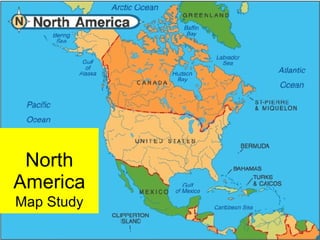
- 1. North America Map Study
- 5. Canal and dam locks At right, a Great Lakes steamer passes through a series of locks to go from one Great Lakes to another.
- 6. The Saint Lawrence Seaway is the system of canals that permits ocean-going vessels to travel from the Atlantic Ocean to the Great Lakes as far as Lake Superior. The Welland Canal (above) connects Lakes Erie and Ontario, bypassing the Niagara Falls on the Niagara River.
- 8. All of the boat traffic that flows into or out of Lake Superior must move through the locks of the St. Mary's River, at Sault Ste. Marie.
- 9. Ohio River
- 11. Mississippi River Drainage Basin
- 12. Mississippi River The Mississippi drains most of the area between the Rocky Mountains and the Appalachian Mountains. It runs through two states — Minnesota and Louisiana — and was used to define the borders of eight states (the river has since shifted) — Wisconsin, Iowa, Illinois, Missouri, Kentucky, Arkansas, Tennessee, and Mississippi — before emptying into the Gulf of Mexico about 100 miles (160 km) downstream from New Orleans.
- 14. Missouri River
- 15. Colorado River
- 16. Rio Grande
- 17. Columbia River
- 18. Yukon River
- 19. Central America and the Caribbean Islands are also part of North America
- 21. Rain forest Tropical rain forests are mainly the product of climatic interactions, particularly temperature and rainfall. They occur where monthly temperature of 20 - 28°C combines with an annual rainfall of 1.5 -10m, evenly distributed throughout the year.
- 22. Central American Rain Forest The tropical rain forest is a forest of tall trees in a region of year-round warmth with an annual average of 50- 260” of rain. These forests belong to the tropical wet climate group .
- 23. Great Plains
- 24. Great Plains The broad expanse of prairie which lies east of the Rocky Mountains in the United States of America and Canada.
- 25. Great Plains In the Prairies ecozone, rivers and streams are slow moving, usually with muddy bottoms. There are few lakes, but many marshes and small shallow ponds.
- 26. The Great Plains cover the center of the continent.
- 28. Prairie The prairie biome is a plant community dominated by grasses and non-grassy herbs with some woody shrubs and occasional trees.
- 29. Temperate grasslands are characterized by hot summers and cold winters. Evaporation rate is high, so little rain makes it into the rich soil. Mid-grass prairie near Manhattan, Kansas Great Plains grasslands
- 30. Rocky Mountains Commonly defined to stretch from the Liard River in British Columbia, down to the Rio Grande in New Mexico. The mountains can also be considered to run to Alaska or Mexico, but usually those mountains are considered to be part of the entire American cordillera, rather than part of the Rockies.
- 31. The Rockies are young scamps that haven’t faced the extra 320 million years of erosion that the Appalachians have suffered and so are much taller.
- 33. The range runs parallel to the Pacific coasts of California, Washington, and Oregon for 4,500 miles in the United States and extend north into Canada for about 1,000 miles and south into Mexico for about 800 miles.
- 35. Cascade Range
- 37. Appalachians A vast system of North American mountains, partly in Canada, but mostly in the United States, extending as a zone, from 100 to 300 miles wide, running from Newfoundland and Labrador, Canada, 1500 miles south-westward to central Alabama in the United States.
- 38. Sierra Madre Occidental and Oriental
- 39. Great Lakes
- 40. Lake Winnipeg
- 41. Lake Okeechobee
- 44. Florida Everglades A subtropical marshland located in the southern portion of the U.S. state of Florida. Much modified by agricultural development in central and southern Florida, the Everglades is the southern half of a large watershed arising in the vicinity of Orlando known as the Kissimmee River system.
- 45. Great Bear & Slave Lakes
- 46. Great Salt Lake
- 47. Gulf of St. Lawrence
- 48. Lago Nicaragua
- 49. Greenland
- 50. Newfoundland
- 52. Lesser Antilles
Notas do Editor
- Although tall-grass prairie once broadly covered the middle of the United States, this biome is now estimated to be at least 99% destroyed from pre-settlement by pioneers, who converted it for agricultural uses.