Canberra
•Transferir como PPTX, PDF•
2 gostaram•3,805 visualizações

How Canberra was chosen as the capital of Australia.

Recomendados
Mais conteúdo relacionado
Mais procurados
Mais procurados (20)
Destaque
Destaque (20)
Semelhante a Canberra
Semelhante a Canberra (20)
Último
Último (20)
Canberra
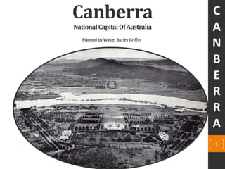
- 1. Canberra NationalCapitalOfAustralia Planned by Walter Burley Griffin C A N B E R R A 1
- 2. 2 INDEX 1. Why & how Canberra became ‘CAPITAL CITY’ ? 2. SiteselectionforCanberra 3. Almost winners (1st runner up) 4. Almost winners(2nd runner up) 5. Canberra,basedonGriffin’splan,1912 6. Inspirations for the Plan of Canberra 7. Land and Water axes 8. Detail plan Of Canberra By Griffin 9. Timeline of construction of new capital city 3 4 5-6 7 8 9-11 12 13 14 C A N B E R R A
- 3. Why & how Canberra became ‘CAPITAL CITY’ ? The most significant reason, which all politicians agreed with at the time, was that whites could only really thrive and lead by living in a cold climate. The other consent, apart from cool temperatures, was that the site should not have a significant settlement, nor should it be on the coast. They couldn't have it on the coast because of the possibility of sea bombardment, and it was also a very bad period for disease, particularly at sea level, so there was a double worry. In 1911, an International Competition (conducted by the Department of Home Affairs) for the design of its new city was launched. Source :- https://www.google.co.in/maps Canberra – Sydney NSW, Australia– 286km Canberra – Melbourne, Victoria, Australia – 669km Nearest Sea is around 200km Walter Burley Griffin, a Chicago landscape architect was the first prize-winner of the International Competition for the design of this city. 3 Fig-1:- Figure showing the distance between Melbourne, Canberra & Sydney. Also, the nearest coastline to Canberra C A N B E R R A
- 4. Site selection for Canberra 4 Source - Lionel Wigmore, 1963. The Long View: A History of Canberra, Australia's National Capital. F.W. Cheshire, University of Michigan, page-33 Fig-2:-The highlighted area is the final site selected by the Federal Commission of Australia for the capital city within the 50 mile radius provided by New South Whales. After the survey was done in 1908, the highlighted area is the final site selected by the Federal Commission of Australia for the capital city from the 50 mile radius provided by New South Whales. Both Sydney and Melbourne got rejected in the survey. C A N B E R R A
- 5. Eliel Saarinen Helsinki, Finland Source – National Archives Of Australia [http://naa.gov.au/] Almost winners (1st runner up) 1. Saarinen’s plan for the governmental centre is particularly effective. It has imposing axes linking prominent locations. 2. The river is forced into an artificial configuration, and has ten bridges, making it an expensive plan to build, made it a failure. 5Fig-3:- The site plan of Canberra, submitted by, Eliel Saarinen (1912) C A N B E R R A
- 6. Illustrating The Design, Construction And Landscaping River Molonglo And Adjacent National Areas Of Canberra, by Eliel Saarinen 6 Eliel Saarinen, Helsinki, Finland Fig-4:- The site plan of Canberra, by, Eliel Saarinen which has more than 10 bridges, were proposed in the plan over the artificial lake. Source – National Archives Of Australia [http://naa.gov.au/] C A N B E R R A
- 7. Alfred Agache Paris, France Almost winners(2nd runner up) 1. Divided the city into quarters – for the university, industry, administration and business. Include an airport as well. 2. Attractive but essentially impractical plan for Canberra. 3. He had less detailed residential quarters in the outlying sections. 4. The Molonglo river traced its usual course through a city in his drawings represent as a ‘mini-Paris’. 5. There was a concern of flooding as the residential units were along the river CIMENTORY MILITARY BARRAKS GOLF COURSE RESIDENTIAL RESIDENTIAL GARDEN CITY GAS WORKS FACTORIES 7 Legend Industrial Uses Institutional uses Recreational uses Residential Transport uses Government /Public Fig-5:- Figure showing the land use in the site plan of Canberra, by, Alfred Agache(1912). Source – National Archives Of Australia [http://naa.gov.au/] C A N B E R R A
- 8. Canberra, based on Griffin’s plan, 1912. 8 Fig-6:-The site plan of Canberra, submitted by, Walter Burley Griffin(1912). Source – National Archives Of Australia [http://naa.gov.au/] C A N B E R R A
- 9. 9 Inspirations for the Plan of Canberra Walter Burley Griffin the designer of Canberra, his design was inspired by by two popular movements of the nineteenth century. “City Beautiful”—an idea used in Chicago City Plan by Daniel Burnham involving planning and landscaping, main buildings around formal water basins. “ English Garden City” by Ebenezer Howard which used parks to screen residential areas by major highways and used street patterns to change directions so as to discourage through traffic from using residential roads as shortcuts. Fig-7: Marion Mahony Griffin drawing of Canberra, seen from Mount Ainslie sumitted in competition(1912) Source - The National Archives of Australia[http://naa.gov.au/] C A N B E R R A
- 10. 10 1. Washington D.C. (1791) Influenced by Pierre Charles L’Enfant’s 1792 design for Washington, D.C.; Griffin designed Canberra with wide, tree-lined avenues that would visually connect significant topographical sites over the city. McMillan’s plan of Washington, D.C. also influenced Griffin very much, and he tried to convey the contemporary City Beautiful movement in his plan as well. Inspirations for the Plan of Canberra Fig-8:- Figure showing the similarity between Washington D.C. plan to that of Canberra Source - Bunnarith Meng, University of Sydney, Sydney, 2002 – Article [PDF file]. Available from http://www2.hawaii.edu/~csaloha/articles/Australian_Capital_Territory_Canberra.pdf. Web. 31 October 2014 C A N B E R R A
- 11. 11 2. Plan of Chicago It is likely that the Griffins were familiar with, and influenced by, the work of fellow Chicagoan Daniel Burnham, whose 1909 Plan of Chicago (Burnham Plan), focussed on reclaiming and improving Chicago’s lakefront for public enjoyment. Inspirations for the Plan of Canberra Fig-10:- Figure showing the changed Molonglo river into an artificial lake by Griffin. The Griffin’s lake centrepiece was a selling point of their design. Source - http://www.nla.gov.au/ Fig-9:-Lakefront designed by Deniel Burnham, Chicago Source - http://www.encyclopedia.chicagohistory.org/pages/300002.html C A N B E R R A
- 12. Land and Water axes Walter Burley Griffin defined two bisecting axes - land and water - that determine the central part of the design of Canberra. The land axis begins at Mount Ainslie, the mountain with the domed building (the Australian War Memorial) at the base, continues across the water axis defined by Lake Burley Griffin, through Parliament House. 12 Fig-11:- Land & Water axis defined by Walter Burley Griffin Source - http://en.wikipedia.org/ MT. AINSLIE C A N B E R R A
- 13. Detail Plan Of Canberra By Griffin 13 Fig-12:- Final detailed plan of Canberra designed by Walter Burley Griffin, 1913 Source - http://en.wikipedia.org/ In 1913 when the National Capital of Australia was about to construct, Griffin made some minor changes in the existing plan to make it more practical design. The residential quarters, suburban areas and Manufacturing section was one of them. C A N B E R R A
- 14. Timeline of construction of new capital city 1912- International design competition was held for designing the capital city of Australia 1913- 12th March 1913- The foundation stone was laid the Capital Hill and the City was formally named Canberra. Mid 1913- Change of governments and the new Ministry appointed Griffin as a Federal Director of Design and Construction. 1914- World war –I, which lead to a new government again and also affected the fast of work on site. 1914- Extension of railway from Queanbeyan to the south-east comer of Canberra, and also a power station was built at Kingston. 1920- Griffin was fired, with little work done due to lack of funding. 1927- The federal legislature moved to Canberra, with the opening of the Provisional Parliament House. 1936 - Walter Burley Griffin died. 14 C A N B E R R A
- 15. Walter Burley Griffin In his own words after winning the competition ...."I am what may be termed a naturalist in architecture. I do not believe in any school of architecture. I believe in architecture that is the logical outgrowth of the environment in which the building in mind is to be located"... From The New York Times, Sunday, June 2, 1912. 15 C A N B E R R A
- 16. 16 Sources Books/E-books Bunnarith Meng, University of Sydney, Sydney, 2002 – Article [PDF file]. Available from http://www2.hawaii.edu/~csaloha/articles/Australian_Capital_Territory_Canber ra.pdf. Web. 31 October 2014 Edmund N. Bacon, 1976. ‘Griffin and Canberra’ in Design of Cities: Revised Edition (Penguin Books). Revised Edition. Penguin Books. Lionel Wigmore, 1963. The Long View: A History of Canberra, Australia's National Capital. F.W. Cheshire, University of Michigan, Online sources National Archives Of Australia [http://naa.gov.au/] Wikipedia http://en.wikipedia.org/Canberra Wikipedia http://en.wikipedia.org/wiki/History_of_Canberra http://www.encyclopedia.chicagohistory.org/pages/300002.html http://www.idealcity.org.au/ http://www.griffinsociety.org/ Google Maps - https://www.google.co.in/maps Google Images - https://www.google.co.in/imghp C A N B E R R A