Nrcan maps
•Transferir como PPTX, PDF•
0 gostou•3,531 visualizações
Denunciar
Compartilhar
Denunciar
Compartilhar

Recomendados
Recomendados
More than Just Lines on a Map: Best Practices for U.S Bike Routes
This session highlights best practices and lessons learned for U.S. Bike Route System designation, as well as how and why these routes should be integrated into bicycle planning at the local and regional level.
Presenters:
Presenter: Kevin Luecke Toole Design Group
Co-Presenter: Virginia Sullivan Adventure Cycling AssociationMore than Just Lines on a Map: Best Practices for U.S Bike Routes
More than Just Lines on a Map: Best Practices for U.S Bike RoutesProject for Public Spaces & National Center for Biking and Walking
Mais conteúdo relacionado
Destaque
More than Just Lines on a Map: Best Practices for U.S Bike Routes
This session highlights best practices and lessons learned for U.S. Bike Route System designation, as well as how and why these routes should be integrated into bicycle planning at the local and regional level.
Presenters:
Presenter: Kevin Luecke Toole Design Group
Co-Presenter: Virginia Sullivan Adventure Cycling AssociationMore than Just Lines on a Map: Best Practices for U.S Bike Routes
More than Just Lines on a Map: Best Practices for U.S Bike RoutesProject for Public Spaces & National Center for Biking and Walking
Destaque (20)
Content Methodology: A Best Practices Report (Webinar)
Content Methodology: A Best Practices Report (Webinar)
How to Prepare For a Successful Job Search for 2024
How to Prepare For a Successful Job Search for 2024
Social Media Marketing Trends 2024 // The Global Indie Insights
Social Media Marketing Trends 2024 // The Global Indie Insights
Trends In Paid Search: Navigating The Digital Landscape In 2024
Trends In Paid Search: Navigating The Digital Landscape In 2024
5 Public speaking tips from TED - Visualized summary
5 Public speaking tips from TED - Visualized summary
Google's Just Not That Into You: Understanding Core Updates & Search Intent
Google's Just Not That Into You: Understanding Core Updates & Search Intent
The six step guide to practical project management
The six step guide to practical project management
Beginners Guide to TikTok for Search - Rachel Pearson - We are Tilt __ Bright...
Beginners Guide to TikTok for Search - Rachel Pearson - We are Tilt __ Bright...
Unlocking the Power of ChatGPT and AI in Testing - A Real-World Look, present...
Unlocking the Power of ChatGPT and AI in Testing - A Real-World Look, present...
More than Just Lines on a Map: Best Practices for U.S Bike Routes
More than Just Lines on a Map: Best Practices for U.S Bike Routes
Ride the Storm: Navigating Through Unstable Periods / Katerina Rudko (Belka G...
Ride the Storm: Navigating Through Unstable Periods / Katerina Rudko (Belka G...
Good Stuff Happens in 1:1 Meetings: Why you need them and how to do them well
Good Stuff Happens in 1:1 Meetings: Why you need them and how to do them well
Nrcan maps
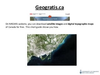
- 1. Geogratis.ca On NRCAN’s website, you can download satellite images and digital topographic maps of Canada for free. This short guide shows you how.
- 2. • Go to http://geogratis.ca/geog ratis/en/index.html • To download maps, click on “Search by Keywords” on the left
- 3. Search for resources in this search box. For instance, you can type in ‘satellite images’ or ‘topographic maps.’
- 4. The first result is the one we want to access to download satellite images of Canada.
- 5. There are different ways you can search for maps: by geoname, postal code, NTS mapsheet or coordinates. We are going to search by NTS Mapsheets : • Click on NTS Mapsheet. Consult the map to determine which mapsheet number corresponds to your area of interest. • To zoom into the area of Toronto, you’ll have to type 30 into the box.
- 6. You’ll notice that the map has zoomed into the area of Southern Ontario. By zooming into the Toronto area, using the zoom-in tool on the left, you can see that NTS sheets of Toronto start with 30M.
- 7. By zooming in further, you’ll see that the NTS sheet corresponding to downtown Toronto is 30M11. To download images, click on “Search available datasets.”
- 8. Select the images of interest to you by checking the box. Then hit Submit.
- 9. Before you download your image, you see this metadata page, which includes important information, such as the projection of the image.
- 10. To download the zipped file of your image, click on the name of the file (next to the downward green arrow). A zipped file with your image is downloaded to your computer.