SlideShare uma empresa Scribd logo
1 de 27
INTENDED LEARNING
OUTCOMES
With the use of world map, the students with
80% accuracy are expected to:
Compare and contrast latitude and
longitude;
Plot the coordinates of a certain place; and
Explain one’s ideas or thoughts the need for
geographic coordinate as a seafarer
LET’S HAVE A
Maps are flat models of three-dimensional objects.
Latitude
Longitude
What’s the difference
between latitude and
longitude?
What are grids?
 Both latitude and
longitude are needed to
locate precise positions
on Earth.
to form
GRID LINES
1. Go to your respective groups
1st TASK:
2. Get your world map
3. List down 10 places (country/
city) from each continent
(except Antartica) you would
like to travel
The first group to
finish will earn bonus
points
IN 3 MINUTES
TIME IS
UP!
FOLD YOUR
PAPER
CROSSWISE
AND SUBMIT
IT INFRONT
Geographic
Coordinate
12 X 3 = 36
122 X 9 = 1 098
15 638 X 127 = 1 986 026
Grids and grid coordinates
Grids and geographic
coordinates are used to locate
places on a map.
Grids are evenly spaced
horizontal and vertical
lines placed on a map.
Letters or numbers are placed along the
sides of a grid. They are combined to give
grid coordinates for any location.
what’s the difference
between
GRID AND GRID
COORDINATES?
Grids and grid coordinates
Alphanumeric means
a combination of
letters and numbers.
 On this map, the grid coordinates are alphanumeric. Locate the sports oval at Blair College.
The oval is easily
located within the
square bounded by
the grid coordinates.
The grid
coordinate
is C3.
Note that the coordinate for the horizontal grid lines is given first,
and the vertical grid coordinate second.
Eastings, and Northings
The numbers that refer to the vertical grid lines are called eastings.They increase in value as you move across in an easterly direction.
The numbers that refer to the horizontal grid lines are called northings.
They increase in value as you move up in a northerly direction.
Eastings, and Northings
3 BASIC WAYS TO DISPLAY COORDINATES
Examples
(given the place/ countries)
6°S ,147°EPapua New
Guinea
4°N ,56°WSuriname
Examples
(given the coordinates)
43°N ,25°E Bulgaria
27°N ,30°E Egypt
51°N ,9°E Germany
1. Find the coordinates of the
places you have listed
2nd TASK:
IN 8 MINUTES
EVALUATION:
On a ¼ sheet of paper give the
corresponding geographic coordinates
or the place of the following:
Vanuatu
Romania
Zimbabwe
20°S ,175°W
15°N ,48°E
China
4°N ,72°W
Denmark 27°N ,133°W
1°N ,38°E
How important geographic
coordinates are as a
seafarer?

Mais conteúdo relacionado

Mais procurados

ACTIVITY-SHEETS-TYPHOON ACTIVITY-SHEETS-TYPHOON ACTIVITY-SHEETS-TYPHOON
ACTIVITY-SHEETS-TYPHOON ACTIVITY-SHEETS-TYPHOON ACTIVITY-SHEETS-TYPHOONACTIVITY-SHEETS-TYPHOON ACTIVITY-SHEETS-TYPHOON ACTIVITY-SHEETS-TYPHOON
ACTIVITY-SHEETS-TYPHOON ACTIVITY-SHEETS-TYPHOON ACTIVITY-SHEETS-TYPHOON
GeralynDamayo
 
Seasons, Earth, Axial Tilt Lesson PowerPoint
Seasons, Earth, Axial Tilt Lesson PowerPointSeasons, Earth, Axial Tilt Lesson PowerPoint
Seasons, Earth, Axial Tilt Lesson PowerPoint
www.sciencepowerpoint.com
 
Balanced and Unbalanced Forces
Balanced and Unbalanced ForcesBalanced and Unbalanced Forces
Balanced and Unbalanced Forces
Rick Turner
 
Punnett Square Lesson Plan
Punnett Square Lesson PlanPunnett Square Lesson Plan
Punnett Square Lesson Plan
jrt004
 
Plate tectonicsslideshow
Plate tectonicsslideshowPlate tectonicsslideshow
Plate tectonicsslideshow
LynnCorliss
 
Earth layers
Earth layersEarth layers
Earth layers
aidad86
 

Mais procurados (20)

ACTIVITY-SHEETS-TYPHOON ACTIVITY-SHEETS-TYPHOON ACTIVITY-SHEETS-TYPHOON
ACTIVITY-SHEETS-TYPHOON ACTIVITY-SHEETS-TYPHOON ACTIVITY-SHEETS-TYPHOONACTIVITY-SHEETS-TYPHOON ACTIVITY-SHEETS-TYPHOON ACTIVITY-SHEETS-TYPHOON
ACTIVITY-SHEETS-TYPHOON ACTIVITY-SHEETS-TYPHOON ACTIVITY-SHEETS-TYPHOON
 
Grade 8 Forces Presentation
Grade 8 Forces PresentationGrade 8 Forces Presentation
Grade 8 Forces Presentation
 
Seasons, Earth, Axial Tilt Lesson PowerPoint
Seasons, Earth, Axial Tilt Lesson PowerPointSeasons, Earth, Axial Tilt Lesson PowerPoint
Seasons, Earth, Axial Tilt Lesson PowerPoint
 
Balanced and Unbalanced Forces
Balanced and Unbalanced ForcesBalanced and Unbalanced Forces
Balanced and Unbalanced Forces
 
Monsoons
MonsoonsMonsoons
Monsoons
 
ppt weathering
ppt weatheringppt weathering
ppt weathering
 
Punnett Square Lesson Plan
Punnett Square Lesson PlanPunnett Square Lesson Plan
Punnett Square Lesson Plan
 
Plate tectonicsslideshow
Plate tectonicsslideshowPlate tectonicsslideshow
Plate tectonicsslideshow
 
Detailed Lesson Plan in Science VII - Greenhouse
Detailed Lesson Plan in Science VII - GreenhouseDetailed Lesson Plan in Science VII - Greenhouse
Detailed Lesson Plan in Science VII - Greenhouse
 
Typhoons - Grade 8
Typhoons - Grade 8Typhoons - Grade 8
Typhoons - Grade 8
 
Grade 8 science teacher's guide
Grade 8 science teacher's guideGrade 8 science teacher's guide
Grade 8 science teacher's guide
 
Common atmospheric phenomena
Common atmospheric phenomenaCommon atmospheric phenomena
Common atmospheric phenomena
 
Earth and Space
Earth and SpaceEarth and Space
Earth and Space
 
Newtons law of motion grade 8
Newtons law of motion grade 8Newtons law of motion grade 8
Newtons law of motion grade 8
 
EARTHQUAKES AND FAULTS
EARTHQUAKES AND FAULTSEARTHQUAKES AND FAULTS
EARTHQUAKES AND FAULTS
 
Factors Affecting the Climate (Bodies of Water, Topography, ocean Current)
Factors Affecting the Climate (Bodies of Water, Topography, ocean Current) Factors Affecting the Climate (Bodies of Water, Topography, ocean Current)
Factors Affecting the Climate (Bodies of Water, Topography, ocean Current)
 
Earth layers
Earth layersEarth layers
Earth layers
 
Periodic Table of Elements Grade 7 1st Quarter
Periodic Table of Elements Grade 7 1st Quarter Periodic Table of Elements Grade 7 1st Quarter
Periodic Table of Elements Grade 7 1st Quarter
 
Continental Drift theory evidences LP
Continental Drift theory evidences LPContinental Drift theory evidences LP
Continental Drift theory evidences LP
 
Earthquakes
EarthquakesEarthquakes
Earthquakes
 

Destaque

Geography lesson plan
Geography lesson planGeography lesson plan
Geography lesson plan
noctor
 
Lesson 2 philippine geography
Lesson 2  philippine geographyLesson 2  philippine geography
Lesson 2 philippine geography
Herbert Corpuz
 
Solar system lesson plan
Solar system lesson planSolar system lesson plan
Solar system lesson plan
foreva100
 
Resources and their Development ( Class X Geography)
Resources and their Development ( Class X Geography)Resources and their Development ( Class X Geography)
Resources and their Development ( Class X Geography)
Krishna Kumar
 
Geographic information system
Geographic information systemGeographic information system
Geographic information system
Sumanta Das
 
Lesson Plan PowerPoint Presentation
Lesson Plan PowerPoint PresentationLesson Plan PowerPoint Presentation
Lesson Plan PowerPoint Presentation
yseauy
 

Destaque (17)

Lesson plan Geography Turkey
Lesson plan Geography TurkeyLesson plan Geography Turkey
Lesson plan Geography Turkey
 
Geography Unit Plan
Geography Unit PlanGeography Unit Plan
Geography Unit Plan
 
Geography lesson plan
Geography lesson planGeography lesson plan
Geography lesson plan
 
5 themes of geography lesson plan[1]
5 themes of geography lesson plan[1]5 themes of geography lesson plan[1]
5 themes of geography lesson plan[1]
 
Introduction to MAPS,Coordinate System and Projection System
Introduction to MAPS,Coordinate System and Projection SystemIntroduction to MAPS,Coordinate System and Projection System
Introduction to MAPS,Coordinate System and Projection System
 
Lesson 2 philippine geography
Lesson 2  philippine geographyLesson 2  philippine geography
Lesson 2 philippine geography
 
Geography PPT lesson
Geography PPT lessonGeography PPT lesson
Geography PPT lesson
 
Understanding Coordinate Systems and Projections for ArcGIS
Understanding Coordinate Systems and Projections for ArcGISUnderstanding Coordinate Systems and Projections for ArcGIS
Understanding Coordinate Systems and Projections for ArcGIS
 
Projections and coordinate system
Projections and coordinate systemProjections and coordinate system
Projections and coordinate system
 
Solar system lesson plan
Solar system lesson planSolar system lesson plan
Solar system lesson plan
 
Lesson plan in philippines geography
Lesson plan in philippines geographyLesson plan in philippines geography
Lesson plan in philippines geography
 
Coordinate systems (Lecture 3)
Coordinate systems (Lecture 3)Coordinate systems (Lecture 3)
Coordinate systems (Lecture 3)
 
Resources and their Development ( Class X Geography)
Resources and their Development ( Class X Geography)Resources and their Development ( Class X Geography)
Resources and their Development ( Class X Geography)
 
Welcome To Geography!
Welcome To Geography!Welcome To Geography!
Welcome To Geography!
 
Geographic information system
Geographic information systemGeographic information system
Geographic information system
 
Weather and Climate lesson for Geography Secondary 1
Weather and Climate lesson for Geography Secondary 1Weather and Climate lesson for Geography Secondary 1
Weather and Climate lesson for Geography Secondary 1
 
Lesson Plan PowerPoint Presentation
Lesson Plan PowerPoint PresentationLesson Plan PowerPoint Presentation
Lesson Plan PowerPoint Presentation
 

Semelhante a Geographic coordinate lesson plan 100415

Geography skills handbook1
Geography skills handbook1Geography skills handbook1
Geography skills handbook1
kjanchild
 
Maps as Models of Earth
Maps as Models of EarthMaps as Models of Earth
Maps as Models of Earth
mlong24
 

Semelhante a Geographic coordinate lesson plan 100415 (20)

Map grids
Map gridsMap grids
Map grids
 
Map grids
Map gridsMap grids
Map grids
 
Earth Science Chapter 1
Earth Science Chapter 1Earth Science Chapter 1
Earth Science Chapter 1
 
RebekahHannonMapSkillsTutorial
RebekahHannonMapSkillsTutorialRebekahHannonMapSkillsTutorial
RebekahHannonMapSkillsTutorial
 
map-reading-made-easy (1).pdf
map-reading-made-easy (1).pdfmap-reading-made-easy (1).pdf
map-reading-made-easy (1).pdf
 
projections.ppt
projections.pptprojections.ppt
projections.ppt
 
projections.ppt
projections.pptprojections.ppt
projections.ppt
 
projections.ppt
projections.pptprojections.ppt
projections.ppt
 
Grid and Area references
Grid and Area referencesGrid and Area references
Grid and Area references
 
Social Science Skills for Years 9-11
Social Science Skills for Years 9-11Social Science Skills for Years 9-11
Social Science Skills for Years 9-11
 
FCP 3 - Map Reading - CFSGT Putland - Mar 10
FCP 3 - Map Reading - CFSGT Putland - Mar 10FCP 3 - Map Reading - CFSGT Putland - Mar 10
FCP 3 - Map Reading - CFSGT Putland - Mar 10
 
Maps as Models of Earth
Maps as Models of EarthMaps as Models of Earth
Maps as Models of Earth
 
Geography skills handbook1
Geography skills handbook1Geography skills handbook1
Geography skills handbook1
 
Readingmaps
ReadingmapsReadingmaps
Readingmaps
 
Spherical Co-ordinate system (Applications)
Spherical Co-ordinate system (Applications)Spherical Co-ordinate system (Applications)
Spherical Co-ordinate system (Applications)
 
Maps as Models of Earth
Maps as Models of EarthMaps as Models of Earth
Maps as Models of Earth
 
ONTAP - Map and Compass
ONTAP - Map and CompassONTAP - Map and Compass
ONTAP - Map and Compass
 
Cartography Unit_ 3.pptx
Cartography Unit_ 3.pptxCartography Unit_ 3.pptx
Cartography Unit_ 3.pptx
 
BOLTSS - Mapping Geography
BOLTSS - Mapping GeographyBOLTSS - Mapping Geography
BOLTSS - Mapping Geography
 
Map Reading
Map ReadingMap Reading
Map Reading
 

Último

1029 - Danh muc Sach Giao Khoa 10 . pdf
1029 -  Danh muc Sach Giao Khoa 10 . pdf1029 -  Danh muc Sach Giao Khoa 10 . pdf
1029 - Danh muc Sach Giao Khoa 10 . pdf
QucHHunhnh
 
Beyond the EU: DORA and NIS 2 Directive's Global Impact
Beyond the EU: DORA and NIS 2 Directive's Global ImpactBeyond the EU: DORA and NIS 2 Directive's Global Impact
Beyond the EU: DORA and NIS 2 Directive's Global Impact
PECB
 
Seal of Good Local Governance (SGLG) 2024Final.pptx
Seal of Good Local Governance (SGLG) 2024Final.pptxSeal of Good Local Governance (SGLG) 2024Final.pptx
Seal of Good Local Governance (SGLG) 2024Final.pptx
negromaestrong
 
1029-Danh muc Sach Giao Khoa khoi 6.pdf
1029-Danh muc Sach Giao Khoa khoi  6.pdf1029-Danh muc Sach Giao Khoa khoi  6.pdf
1029-Danh muc Sach Giao Khoa khoi 6.pdf
QucHHunhnh
 

Último (20)

1029 - Danh muc Sach Giao Khoa 10 . pdf
1029 -  Danh muc Sach Giao Khoa 10 . pdf1029 -  Danh muc Sach Giao Khoa 10 . pdf
1029 - Danh muc Sach Giao Khoa 10 . pdf
 
Asian American Pacific Islander Month DDSD 2024.pptx
Asian American Pacific Islander Month DDSD 2024.pptxAsian American Pacific Islander Month DDSD 2024.pptx
Asian American Pacific Islander Month DDSD 2024.pptx
 
Beyond the EU: DORA and NIS 2 Directive's Global Impact
Beyond the EU: DORA and NIS 2 Directive's Global ImpactBeyond the EU: DORA and NIS 2 Directive's Global Impact
Beyond the EU: DORA and NIS 2 Directive's Global Impact
 
How to Give a Domain for a Field in Odoo 17
How to Give a Domain for a Field in Odoo 17How to Give a Domain for a Field in Odoo 17
How to Give a Domain for a Field in Odoo 17
 
Sociology 101 Demonstration of Learning Exhibit
Sociology 101 Demonstration of Learning ExhibitSociology 101 Demonstration of Learning Exhibit
Sociology 101 Demonstration of Learning Exhibit
 
Presentation by Andreas Schleicher Tackling the School Absenteeism Crisis 30 ...
Presentation by Andreas Schleicher Tackling the School Absenteeism Crisis 30 ...Presentation by Andreas Schleicher Tackling the School Absenteeism Crisis 30 ...
Presentation by Andreas Schleicher Tackling the School Absenteeism Crisis 30 ...
 
Holdier Curriculum Vitae (April 2024).pdf
Holdier Curriculum Vitae (April 2024).pdfHoldier Curriculum Vitae (April 2024).pdf
Holdier Curriculum Vitae (April 2024).pdf
 
Seal of Good Local Governance (SGLG) 2024Final.pptx
Seal of Good Local Governance (SGLG) 2024Final.pptxSeal of Good Local Governance (SGLG) 2024Final.pptx
Seal of Good Local Governance (SGLG) 2024Final.pptx
 
1029-Danh muc Sach Giao Khoa khoi 6.pdf
1029-Danh muc Sach Giao Khoa khoi  6.pdf1029-Danh muc Sach Giao Khoa khoi  6.pdf
1029-Danh muc Sach Giao Khoa khoi 6.pdf
 
microwave assisted reaction. General introduction
microwave assisted reaction. General introductionmicrowave assisted reaction. General introduction
microwave assisted reaction. General introduction
 
INDIA QUIZ 2024 RLAC DELHI UNIVERSITY.pptx
INDIA QUIZ 2024 RLAC DELHI UNIVERSITY.pptxINDIA QUIZ 2024 RLAC DELHI UNIVERSITY.pptx
INDIA QUIZ 2024 RLAC DELHI UNIVERSITY.pptx
 
Unit-IV- Pharma. Marketing Channels.pptx
Unit-IV- Pharma. Marketing Channels.pptxUnit-IV- Pharma. Marketing Channels.pptx
Unit-IV- Pharma. Marketing Channels.pptx
 
2024-NATIONAL-LEARNING-CAMP-AND-OTHER.pptx
2024-NATIONAL-LEARNING-CAMP-AND-OTHER.pptx2024-NATIONAL-LEARNING-CAMP-AND-OTHER.pptx
2024-NATIONAL-LEARNING-CAMP-AND-OTHER.pptx
 
Grant Readiness 101 TechSoup and Remy Consulting
Grant Readiness 101 TechSoup and Remy ConsultingGrant Readiness 101 TechSoup and Remy Consulting
Grant Readiness 101 TechSoup and Remy Consulting
 
On National Teacher Day, meet the 2024-25 Kenan Fellows
On National Teacher Day, meet the 2024-25 Kenan FellowsOn National Teacher Day, meet the 2024-25 Kenan Fellows
On National Teacher Day, meet the 2024-25 Kenan Fellows
 
Energy Resources. ( B. Pharmacy, 1st Year, Sem-II) Natural Resources
Energy Resources. ( B. Pharmacy, 1st Year, Sem-II) Natural ResourcesEnergy Resources. ( B. Pharmacy, 1st Year, Sem-II) Natural Resources
Energy Resources. ( B. Pharmacy, 1st Year, Sem-II) Natural Resources
 
Class 11th Physics NEET formula sheet pdf
Class 11th Physics NEET formula sheet pdfClass 11th Physics NEET formula sheet pdf
Class 11th Physics NEET formula sheet pdf
 
Basic Civil Engineering first year Notes- Chapter 4 Building.pptx
Basic Civil Engineering first year Notes- Chapter 4 Building.pptxBasic Civil Engineering first year Notes- Chapter 4 Building.pptx
Basic Civil Engineering first year Notes- Chapter 4 Building.pptx
 
Ecological Succession. ( ECOSYSTEM, B. Pharmacy, 1st Year, Sem-II, Environmen...
Ecological Succession. ( ECOSYSTEM, B. Pharmacy, 1st Year, Sem-II, Environmen...Ecological Succession. ( ECOSYSTEM, B. Pharmacy, 1st Year, Sem-II, Environmen...
Ecological Succession. ( ECOSYSTEM, B. Pharmacy, 1st Year, Sem-II, Environmen...
 
PROCESS RECORDING FORMAT.docx
PROCESS      RECORDING        FORMAT.docxPROCESS      RECORDING        FORMAT.docx
PROCESS RECORDING FORMAT.docx
 

Geographic coordinate lesson plan 100415

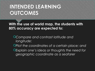
  • 1. INTENDED LEARNING OUTCOMES With the use of world map, the students with 80% accuracy are expected to: Compare and contrast latitude and longitude; Plot the coordinates of a certain place; and Explain one’s ideas or thoughts the need for geographic coordinate as a seafarer
  • 3. Maps are flat models of three-dimensional objects. Latitude Longitude
  • 4. What’s the difference between latitude and longitude?
  • 6.  Both latitude and longitude are needed to locate precise positions on Earth. to form GRID LINES
  • 7. 1. Go to your respective groups 1st TASK: 2. Get your world map 3. List down 10 places (country/ city) from each continent (except Antartica) you would like to travel The first group to finish will earn bonus points IN 3 MINUTES
  • 8.
  • 9.
  • 10.
  • 13. 12 X 3 = 36 122 X 9 = 1 098 15 638 X 127 = 1 986 026
  • 14.
  • 15. Grids and grid coordinates Grids and geographic coordinates are used to locate places on a map. Grids are evenly spaced horizontal and vertical lines placed on a map. Letters or numbers are placed along the sides of a grid. They are combined to give grid coordinates for any location.
  • 16. what’s the difference between GRID AND GRID COORDINATES?
  • 17. Grids and grid coordinates Alphanumeric means a combination of letters and numbers.  On this map, the grid coordinates are alphanumeric. Locate the sports oval at Blair College. The oval is easily located within the square bounded by the grid coordinates. The grid coordinate is C3. Note that the coordinate for the horizontal grid lines is given first, and the vertical grid coordinate second.
  • 18. Eastings, and Northings The numbers that refer to the vertical grid lines are called eastings.They increase in value as you move across in an easterly direction.
  • 19. The numbers that refer to the horizontal grid lines are called northings. They increase in value as you move up in a northerly direction. Eastings, and Northings
  • 20.
  • 21. 3 BASIC WAYS TO DISPLAY COORDINATES
  • 22.
  • 23. Examples (given the place/ countries) 6°S ,147°EPapua New Guinea 4°N ,56°WSuriname
  • 24. Examples (given the coordinates) 43°N ,25°E Bulgaria 27°N ,30°E Egypt 51°N ,9°E Germany
  • 25. 1. Find the coordinates of the places you have listed 2nd TASK: IN 8 MINUTES
  • 26. EVALUATION: On a ¼ sheet of paper give the corresponding geographic coordinates or the place of the following: Vanuatu Romania Zimbabwe 20°S ,175°W 15°N ,48°E China 4°N ,72°W Denmark 27°N ,133°W 1°N ,38°E

Notas do Editor

  1. <number>
  2. <number>
  3. <number> Grids and grid coordinates On click - image appears ‘Compass and map’ On click - text appears ‘Grids and geographic coordinates are used to locate places on a map.’ On click - text appears ‘Grids are evenly spaced horizontal and vertical lines placed on a map.’ On click - text appears ‘Letters or numbers are placed along the sides of a grid. They are combined to give grid coordinates for any location.’
  4. <number> Grids and grid coordinates On click - map appears ‘Alphanumeric grid map’ On click - text appears ‘On this map, the grid coordinates are alphanumeric.’ On click - text appears ‘Alphanumeric means a combination of letters and numbers.’
  5. <number> Eastings, northings and area references On click - text appears ‘The numbers that refer to the vertical grid lines are called eastings.’
  6. <number> Eastings, northings and area references On click - text appears ‘The numbers that refer to the horizontal grid lines are called northings. They increase in value as you move up in a northerly direction.’