Part 4. 2014 notable disasters. floods

Floods, which can be either slow onset or rapid onset events (i.e., flash floods), occur when a locale cannot process the amount of water that it is receiving in a normal manner. Communities throughout the world know why it is urgent for their stakeholders to continue working on becoming FLOOD and especially FLOOD-INDUCED LANDSLIDE DISASTER RESILIENT. Each community knows that it is only a matter of time until the inevitable flood event occurs that can expose its physical and social vulnerabilities. THE REASONS FOR A FLOOD DISASTER TO OCCUR: The community is UN-PREPARED for the flood hazards (INUNDATION, LANDSLIDES, etc.,) that are likely to happen. The community has NO DISASTER PLANNING SCENARIO or LAND USE PLANS or ORDINANCES in place as a strategic framework for identification and coordinated local, national, regional, and international countermeasures. The community has NO EARLY WARNING SYSTEM or COMMINITY EVACUATION PLANS in place as a strategic framework for identi-fication and coordinated local, national, regional, and international countermeasures. The community LACKS THE CAPACITY TO RESPOND to the full spectrum of expected and unexpected emergency situations in a timely and cost-effective manner. The community is INEFFECIVE during recovery and reconstruction because it HAS NOT LEARNED IMPORTANT LESSONS from either the current experience or the cumulative prior experiences.

Recomendados
Mais conteúdo relacionado
Mais procurados
Mais procurados (20)
Destaque
Destaque (20)
Semelhante a Part 4. 2014 notable disasters. floods
Semelhante a Part 4. 2014 notable disasters. floods (20)
Mais de Professor Eric K. Noji, M.D., MPH, DTMH(Lon), FRCP(UK)hon
Mais de Professor Eric K. Noji, M.D., MPH, DTMH(Lon), FRCP(UK)hon (20)
Último
Último (20)
Part 4. 2014 notable disasters. floods
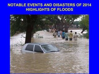
- 1. NOTABLE EVENTS AND DISASTERS OF 2014 HIGHLIGHTS OF FLOODS
- 2. 2014: FLOODS ARE A GLOBAL NATURAL HAZARD CONTINUUM • FLOODS • SEVERE WINDSTORMS • EARTHQUAKES • DROUGHTS • VOLCANIC ERUPTIONS • ETC.
- 3. FLOODS • Floods occur somewhere in the world 10,000 times or more each year.
- 4. FLOOD-INDUCED LANDSLIDES • Many of the global flood occurrences also trigger landslides, mudslides, mudflows, and rock falls.
- 5. FLOODS • Floods, which can be either slow onset or rapid onset events (i.e., flash floods), occur when a locale can not process the amount of water that it is receiving in a normal manner.
- 6. FLOODS occur when water accumulates too rapidly to be processed in the locale from: a) natural events such as rainfall and snow melt, b) storm surge and heavy rain from hurricanes and typhoons, and c) tsunami waves
- 9. THE “PINEAPPLE EXPRESS” FLOODS • Pineapple Express is a non- technical, meteorological term for an “atmospheric river” of moisture from the waters adjacent to the Hawaiian Islands that extend to any location along the Pacific coast of North America.
- 10. LOSS OF FUNCTION OF STRUCTURES IN FLOODPLAIN FLOODS INUNDATION INTERACTION WITH HAZARDOUS MATERIALS STRUCTURAL/CONTENTS DAMAGE FROM WATER WATER BORNE DISEASES (HEALTH PROBLEMS) EROSION AND MUDFLOWS CONTAMINATION OF GROUND WATER CAUSES OF RISK CASE HISTORIES
- 11. WIND PENETRATING BUILDING ENVELOPE SEVERE WINDSTORMS UPLIFT OF ROOF SYSTEM FLYING DEBRIS STORM SURGE IRREGULARITIES IN ELEVATION AND PLAN SITING PROBLEMS FLOODING AND LANDSLIDES CAUSES OF DAMAGE “DISASTER LABORATORIES”
- 12. HIGH VELOCITY IMPACT OF INCOMING WAVES TSUNAMIS INLAND DISTANCE OF WAVE RUNUP VERTICAL HEIGHT OF WAVE RUNUP INADEQUATE RESISTANCE OF BUILDINGS FLOODING INADEQUATE HORIZONTAL AND VERTICAL EVACUATION PROXIMITY TO SOURCE OF TSUNAMI CAUSES OF DAMAGE “DISASTER LABORATORIES”
- 13. NOTE: INUNDATION BECOMES A POTENTIAL DISASTER AGENT WHEN IT a) TRIGGERS LANDSLIDES, b) INTERACTS WITH A COMMUNITY’S BUILDINGS, CRITICAL INFRASTRUCTURE, CROPS, AND c) CREATES A FAVORABLE ENVIRONMENT FOR INFECTIOUS DISEASES
- 14. 2014: EXAMPLES OF NOTABLE FLOOD EVENTS FLOOD EVENTS Flood-induced Mudslide in Washington After the Iquique, Chile Tsunami After Typhoon Hagupit in The Philippines The “Pineapple Express” in California
- 15. FLOOD-INDUCED MUDSLIDE IN WASHINGTON STATE, USA SATURDAY, MARCH 22, 2014
- 16. LOCATION MAP
- 17. THE 2014 MUDSLIDE • The slide, which occurred on Saturday morning, was triggered by heavy rainfall and reported to be about 25 m (80 feet) deep in some parts.
- 18. THE 2014 MUDSLIDE • Officials described the mudslide as "a big wall of mud and debris” that blocked about a mile of State Route 530 near the town of Oso, about 55 miles north of Seattle.
- 19. WALL OF MUD MOVED AFTER HEAVY RAINFALL
- 20. THE MUDSLIDE
- 21. THE MUDSLIDE
- 22. NEITHER THE LOCATION NOR THE EVENT WERE A SURPRISE
- 23. PRIOR PREPAREDNESS ACTIVITIES • In 2006 after a smaller landslide occurred on the north fork of the Stillaguamish River, millions of dollars were spent on regional mitigation measures.
- 24. PRIOR PREPAREDNESS ACTIVITIES • In 2010, a report commissioned by the county in order to be in compliance with federal regulations identified the hillside that collapsed Saturday outside of the community of Oso as particularly susceptible.
- 25. The 15 million cubic foot mudslide destroyed about 50 homes
- 26. PREPARING FOR SEARCH AND RESCUE
- 27. THE DILEMNA FOR SEARCH AND RESCUE TEAMS • The debris pile was about a square mile (2 1/2 square kilometers) and 30 to 80 feet (9 to 25 meters) deep in places, with a surface that includes quicksand- like muck, rain-slickened mud, and ice. • The terrain was difficult to navigate on foot and very treacherous when heavy equipment was brought in.
- 28. THE DILEMNA FOR SEARCH AND RESCUE TEAMS • To make matters worse, the debris pile includes other hazards such as fallen trees, propane and septic tanks, twisted vehicles, and countless pieces of shattered homes
- 29. --- AND CONTINUING RAINFALL INCREASED THE LIKELIHOOD OF FLASH FLOODS AND ADDITIONAL MUDSLIDES
- 30. SAR: SLOW, DANGEROUS WORK WITH FEW SUCCESSES
- 31. 176 MISSING 14 DEAD AS OF TUESDAY, MARCH 25
- 33. Specialized teams and high- tech equipment — including technology to locate cellphone pings under the wreckage — were deployed
- 35. Due to the dangerous environment, as bodies were being discovered underneath the rubble, they are being flown out together in groups each afternoon instead of one at a time in helicopters.
- 36. TSUNAMI WAVE RUN UP IN IQUIQUE, CHILE APRIL 1, 2014
- 37. IQUIQUE, CHILE EARTHQUAKE (April 1, 2014)
- 38. IQUIQUE, CHILE: FLOODING FROM TSUNAMI WAVE RUN UP
- 39. TYPHOON HAGUPIT STRIKES THE PHILIPPINES December 6-8, 2014
- 40. Typhoon Hagupit made a painfully slow landfall at 11 kph (7 mph) in the Philippines on Saturday, lashing the island of Samar with 200 kph (125 mph) winds and unloading at least 40 cm (16 in) of rain over coastal areas.
- 41. Typhoon Hagupit, known locally asTyphoon Ruby, first landed at Eastern Samar on Saturday and moved slowly across the country, bringing heavy rains and strong winds.
- 42. 3 DAYS OF HEAVY RAINFALL
- 43. At least 21 people in the Philippines were killed before Typhoon Hagupit weakened into a tropical storm Monday. The storm forced more than one million people out of their homes and into shelters.
- 44. THE “PINEAPPLE EXPRESS” STRIKES CALIFORNIA 11-14 DECEMBER 2014
- 45. A weather system fueled by the "Pineapple Express," a long, narrow atmospheric plume that continuously piped moisture from Hawaii into the western United States, started delivering heavy rainfall to the San Francisco area and the entire state on 10 December.
- 46. RAIN, AND MORE RAIN
- 47. RAIN-INDUCED MUDSLIDE: PACIFIC COAST HIGHWAY
- 48. RAIN-INDUCED ROCK SLIDE: SOME HOUSES BURIED
- 49. BEYOND 2014: Communities throughout the world know why it is urgent for their stakeholders to continue working on becoming FLOOD and FLOOD-INDUCED LANDSLIDE DISASTER RESILIENT
- 50. Each community knows that it is only a matter of time until the inevitable flood event e occurs that can expose its physical and social vulnerabilities
- 51. YOUR COMMUNITY DATA BASES AND INFORMATION HAZARDS: GROUND SHAKING GROUND FAILURE SURFACE FAULTING TECTONIC DEFORMATION TSUNAMI RUN UP AFTERSHOCKS •MONITORING •HAZARD MAPS •INVENTORY •VULNERABILITY •LOCATION RISK ACCEPTABLE RISK UNACCEPTABLE RISK BOOKS OF KNOWLEDGE •PREPAREDNESS •PROTECTION •EARLY WARNING •EM RESPONSE •RECOSTRUCTION AND RECOVERY FLOOD DISASTER RESILIENCE
- 52. THE PEOPLE CONTINUUM 7 + BILLION (DISTRIBUTED IN COMMUN-ITIES AND RURAL AREAS THROUGHOUT THE WORLD)
- 53. THE COMMUNITY CONTINUUM: (BUILDINGS. INFRASTRUCTURE, ENTERPRISE) • GOVERNMENTS • DWELLINGS • SCHOOLS • HEALTH CARE FACILITIES • BUSINESSES • INFRA- STRUCTURE
- 54. THE REASONS FOR A FLOOD DISASTER TO OCCUR. . . The community is UN-PREPARED for the flood hazards (INUNDATION, LANDSLIDES, etc.,) that are likely to happen.
- 55. THE REASONS ARE . . . The community has NO DISASTER PLANNING SCENARIO or LAND USE PLANS or ORDINANCES in place as a strategic framework for identification and coordinated local, national, regional, and international countermeasures.
- 56. THE REASONS ARE . . . The community has NO EARLY WARNING SYSTEM or COMMINITY EVACUATION PLANS in place as a strategic framework for identi- fication and coordinated local, national, regional, and international countermeasures.
- 57. THE REASONS ARE . . . The community LACKS THE CAPACITY TO RESPOND to the full spectrum of expected and unexpected emergency situations in a timely and cost- effective manner.
- 58. THE REASONS ARE . . . The community is INEFFECIVE during recovery and reconstruction because it HAS NOT LEARNED IMPORTANT LESSONS from either the current experience or the cumulative prior experiences.