
Recomendados
Mais conteúdo relacionado
Mais procurados
Mais procurados (20)
Semelhante a Latitude and longitude powerpoint
Semelhante a Latitude and longitude powerpoint (20)
Mais de edwatt
Último
Último (20)
Latitude and longitude powerpoint
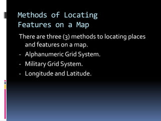
- 1. Methods of Locating Features on a Map There are three (3) methods to locating places and features on a map. - Alphanumeric Grid System. - Military Grid System. - Longitude and Latitude.
- 3. 33 34 35 36 37 38 39 22 21 20 19 18 17 16 . A . B . C . D
- 4. Lines of Latitude - Are imaginary lines. - They run east to west around the globe. - They are parallel to one another. - They are located approximately 111km apart on the earth’s surface.
- 6. Geography of Canada Longitude Imaginary lines on a map that divides the planet into vertical wedges. Sometimes these lines are called Meridians They do not run parallel to each other, but converge at the North / South Poles. The line of longitude at 00 is called the Prime Meridian and can be located in Greenwich, London, England. The International Dateline is at 1800 and is found on the opposite side of the planet.
- 7. Geography of Canada Longitude Time Zones the planet is divided into one hour segments. each segment is approximately 150 and makes up 24 sections/hours. Canada has six (6) time zones (Newfoundland, Atlantic, Eastern, Central, Mountain & Pacific.
- 8. Geography of Canada Longitude Navigation Uses lines of longitude are used in unison with latitudinal lines to locate places and features on a map. found in GPS, satellites, military, aviation, nautical systems, etc.
- 9. Assignment for Today Textbook Assignment - Read pages 30-37. - Answer questions 1- 10 on page 32. - Complete the “Take aTrip” paragraphs by filling in the blanks in the story. - First to complete the “Take aTrip” assignment (page 36) accurately will win a prize.
- 10. Geography of Canada: Longitude Time Zones Canadian, Sir Stanford Fleming, proposed a worldwide system of time zones in 1879. He advocated his system at several international conferences, thus is widely credited with the invention. By about 1900, almost all time on Earth was in the form of standard time zones, only some of which used an hourly offset from GMT.
- 13. Geography of Canada Time Zones Why are the time zones not always 15o? Political - Major cities in an area will have the same time. - Opening and closing of government offices would be standard in an area. - Provinces will have standard for continuity. Economical - Stores and offices will be open at convenient times of the day. - People leaving home will have the same time as their place of work. - Phoning /emailing places around the world will be standardized by region. Social - People with similar cultural characteristics who live in a particular region will have a standard time.
- 14. Geography of Canada Time Zones How are the Zones determined? - Using water barriers, like rivers, lakes and seas. - Physical barriers, like mountains, deserts, forests. - Political boundaries could be used to separate time zones. Any physical or human feature that causes a natural break in the communication between populations living in an area.
- 16. Geography of Canada The 24 hour Clock 01:00 = 1am 02:00 = 2am 11:00 = 11am 13:00 = 1pm 16:00 = 4pm 19:00 = 7pm 21:00 = 9pm 23:00 = 11pm
- 17. Geography of Canada Answer the Question You have a flight from St. John’s, Newfoundland which takes off at 7am.The flight is to Edmonton and will take 4 hours.What is the time in Edmonton when you arrive? Answer The time in St. John’s when you arrive in Edmonton is 11am. Edmonton’s time difference is 3.30 hours. Therefore the time of arrival is 7.30am.