

Recomendados
Mais conteúdo relacionado
Mais procurados
Mais procurados (20)
Semelhante a Faulting
Semelhante a Faulting (20)
Último
Último (20)
Faulting
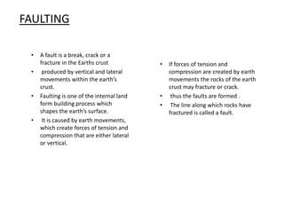
- 1. FAULTING • A fault is a break, crack or a fracture in the Earths crust • produced by vertical and lateral movements within the earth’s crust. • Faulting is one of the internal land form building process which shapes the earth’s surface. • It is caused by earth movements, which create forces of tension and compression that are either lateral or vertical. • If forces of tension and compression are created by earth movements the rocks of the earth crust may fracture or crack. • thus the faults are formed . • The line along which rocks have fractured is called a fault.
- 2. Types of Faults • Normal fault • Reverse fault • Tear/Shear fault • Thrust fault • Anticlinal fault
- 3. Formed when rocks are subjected to tensional forces . Normal faults develops. One block of land slides downwards in relation to the other. These types of faults are common in the East African section of the Great Rift valley. Normal Fault Down throw upthrow
- 4. Reverse faults • These are also known as thrust faults . • caused by the forces of compression. • when the strata or layers are compressed or pressed ,the rocks will crack and faults will be formed. • One block of rocks may override another to form a block . • mountain or a horst. • Such faults are common in western Uganda. • The Ruwenzori mountain is an example of a block mountain formed by thrust faults Down throw Up throw
- 5. Tear faults When lateral movement is taking place particularly during an earthquake, tear faults may occur. Tear faults are also known as wrench or transform faults. If a tear fault occurs across the course of a river, then the river’s course may be slightly offset.
- 6. FEATURES FORMED (PRODUCED) AS A RESULT OF FAULTING Faulting has produced a variety of physical features over the surface of the earth. Among the most remarkable features are; Block mountains Rift Valleys Tilt blocks Escarpments/Fault scarp
- 7. A BLOCK MOUNTAIN A block mountain is also known as a Horst. It is formed when the middle block which is bounded by more or less parallel faults is made to rise or is uplifted by the compressional forces. The best example of a block mountain in East Africa is mount. Ruwenzori ranges, also known as the mountains of the moon. Others include Mathews ranges and Nyiru Ndoto in Northern Kenya. Ablockmountainisalsoknownasa Horst.It
- 8. Rift valleys or grabens
- 9. Tilt Blocks Tilt blocks are formed when one side of the middle block is uplifted higher than the other side. The top of the middle block will not be flat but will be tilted. E.g. west Kenya tilt block, which rises to about 1900 meters towards lake Victoria.
- 10. Escarpments Escarpments are steep cliff-like slopes. Escarpments are said to have been formed during the formation of the rift valleys. Some escarpments are steep and may extend several hundreds of kilometers . When escarpments are eroded, they become fault scarps. Examples of such escarpments in East Africa include: Nandi(Kenya) Butiaba (Uganda) Elgeyo Marakwet (Kenya) Kikuyu (Kenya) Mau (Kenya) Lake Manyara (Tanzania) Nyando (Kenya) Keiyo (Kenya) Nyandarua or Aberdares (Kenya) Chuya (Tanzania.)
- 11. Problems faced by the people living in the Rift valley areas of East Africa High temperatures lead to shortage of water. Earthquakes (tremors) which destroy property Little rainfall or drought in the Rain shadow areas Poor means of transport and communication because of the steep escarpments
- 12. Importance of faulting • Faulting has resulted into the formation of high mountains in East Africa. For example the Ruwenzori in western Uganda, the southern highlands and the Usambara mountains in Tanzania and the Mathew ranges in Kenya. These are the most productive areas, where both cash crops and subsistence crops are grown. • These highlands receive abundant and reliable rainfall. • Rift valley lakes for example L. Tanganyika, lake Turkana, lake Naivasha and lake Baringo are fishing grounds. • Some of these lakes have fresh water which can be used for irrigation and also for domestic purposes and industrial use. • L.Magadi contains vast deposits of soda ash, which is one of the most important minerals in Kenya. • Faulting presents an impressive scenery which can be used for tourism. For example L.Nakuru has millions of colorful flamingos and other birds. • Some highlands have been made into National parks and game reserves e.g. the slopes of the Nyandarua and Ruwenzori mountains . These parks attract many tourists. • Faulting can also cause the formation of waterfalls such as the Karuma falls, Murchison falls. • Problems caused by faulting • Escarpments and mountains hinder transport development. • Rift valleys are very hot and only suitable for grazing because they are in the rain shadow unless irrigation is practiced as with the case of mubuku. • There is severe soil erosion and mass wasting on the step slopes which result in the destruction of soil surface, crops and at times people's property. For example Ruwenzori mountains. • It is difficult to settle on the steep areas on the rift valley escarpments.
- 13. RIFT VALLEYS A rift valley is an elongated trough bound by two in- facing escarpments. Rift valleys are long, narrow depressions on the earth surface bounded by more or less parallel faults. A rift valley is also known as a graven. Rift valleys are thought to have been developed either from the action of tensional forces in the crust or from the action of compressional forces. The East Africa rift valley system extends southwards from the Red sea. Through Ethiopia and East Africa to Malawi. The east Africa rift valley covers a distance of approximately 5,600km .it is divided into two branches that is, the western rift valley and the eastern rift valley. The Western branch stretches from lake Albert in Uganda to lake Malawi. The eastern branch stretches from lake Turkana in northern Kenya to lake Malawi. The width of the rift valley varies from place to place. The average width is between 50km and 60km. On the floor of the rift valley there are a number of rift lakes and volcanic craters such as Longonot crater and Menengai craters.
- 14. Origin of the rift valleys • A number of theories have been put forward to explain the origin of rift valleys. However, two have remained popular thus, there the two theories which attempt to explain the origin of rift valleys. One relies on the forces of tension and the other on the forces of compression. Both theories depend on upward swells, along the sides of which faults develop.
- 15. Origin of the rift valleys Theory 1: Tensional forces Theory 2. Compressional forces After subsidence a depression with steep fault scarp sides i.e. a rift valley is formed. It is trapped in position by later pressure. Theory 1: Tensional forces a) Tension forces act on the layers of rock b) Gradually two parallel faults appear and the central block begins to subside (sink). c) Land in between sinks in forming a rift valley. The land on either sides stays in place. a) Layers of rocks are subjected to compressional forces. b) Faults develop and the outer blocks move upwards (Reverse faults are formed). c) Central block stays in place and a rift valley is formed.
- 16. RIFT VALLEY LAKES • These have been formed on the floor of the rift valley and they vary in size, depth and salinity. Examples of the salty lakes are Natron, and Magadi. The rift valley has several in land water basins which contain lakes. Rift valley lakes of East Africa i.e. • Kenya • Uganda • Tanzania include: • L. Turkana • L. Tanganyika • L. Baringo • L. Edward • L .Rukwa • L. Nakuru • L. George. • L. Natron • L .Elmentaita • L .Eyasi • L. Naivasha • L. Manyara. • L. Albert • L. Magadi
- 17. FAULTED AREAS IN EAST AFRICA • There are faulted areas in east Africa outside the rift valley such as: • Kavirondo rift at Kisumu. • Northern face of which is the Nandi scarp • Usambara mountains have fault scarps
- 18. Benefits of the Rift valley to the people of East Africa • The beautiful scenery attracts tourists • Lakes in the Rift valley provide fish. For example L . Tanganyika, L. Albert etc. • Rift valley lakes provide water for domestic and agricultural use • Lakes help in navigation (water transport). • Forests on the slopes are sources of timber • Gentle slopes are used for crop farming and settlement due to fertile soils • Rift valley lakes are used for mining for example soda ash from L. Magadi • Areas of little rainfall (rain shadow) provides pasture for grazing| • Study purposes or research • Wildlife conservation. For example game parks in rift valley areas.