SlideShare uma empresa Scribd logo
1 de 5
Baixar para ler offline
Moscow slams Kiev’s MH17 satellite data — RT
News
Published time: August 01, 2014 10:27
Edited time: August 03, 2014 16:11
The satellite image on the left was provided by the Russian Defense Ministry on 14 July, 2014. On
the right is the image that Kiev claims were taken by its satellites on July 16, 2014. Image from
mil.ru
Satellite images Kiev published as 'proof' it didn't deploy anti-aircraft batteries around the MH17
crash site carry altered time-stamps and are from days after the MH17 tragedy, the Russian Defense
Ministry has revealed.
The images, which Kiev claims were taken by its satellites at the same time as those taken by
Russian satellites, are neither Ukrainian nor authentic, according to Moscow's statement.
The Defense Ministry said the images were apparently made by an American KeyHole
reconnaissance satellite, because the two Ukrainian satellites currently in orbit, Sich-1 and Sich-2,
were not positioned over the part of Ukraine's Donetsk Region shown in the pictures.
Moscow claims weather and lighting conditions in the images were not possible at the dates and
times Ukraine claims they were made, the Russian ministry said.
At least one of the images published by Ukraine shows signs of being altered by an image editor, the
statement added.
The ministry also criticized images published by Kiev to back its allegations that Russia smuggled
heavy weapons over the border and shelled Ukrainian army positions.
The images lack proper time stamps and coordinates, while Kiev didn't bother to explain why it
believes that whatever vehicles are shown in them are Russian, the statement said.
"It's the latest 'masterpiece' in the Ukrainian exercise in conspiracy theories, an attempt to divert
responsibility," the ministry said.
"It can take a deserved place next to other allegations against Russia voiced by Kiev that claimed
that Russia was responsible for masterminding the Maidan protest and the tragedy in Odessa."
"Apparently that's why the real owners of those photos are hesitating to publish them under their
own name, since it would derail the myth of the omniscience of their space reconnaissance," the
Russian ministry said.
A comparison of satellite images published by Russia and Ukraine as presented by Kiev in an
attempt to dispute the authenticity of Moscow's photos. The shadows are cast in different directions
in the two images, proving that they could not have been almost at the same time two days apart, as
indicated by the time stamps.
The weather is also clearly different, with the Russian image showing a cloudy day, while the image
presented by Kiev shows a clear day - showing that the images could not have been taken less than
an hour apart, as claimed by the time stamps. The Russian military say the actual weather conditions
at the time can be easily double-checked by independent sources.
In another comparison with the images used by Ukraine, it was purposely degraded in quality in
order to point out some irregularities. No such irregularities are present in the original image, the
Russian military said.
Malaysian Airlines flight MH17 crashed in Ukraine's Donetsk Region, which is engulfed by armed
hostilities between Ukrainian troops and local militias. The plane was apparently shot down by a
missile, although neither the type of missile nor who shot it has yet been properly established.
As a troubled investigation into the tragedy, which claimed almost 300 lives, is underway, Kiev and
some Western countries were quick to say that the militias and Russia were culpable for the deed.
Kiev said it had no capabilities to take down the plane.
The Russian Defense Ministry published satellite images and radar data, saying that evidence
proved that Ukraine had both ground-based anti-aircraft batteries and military aircraft capable of
firing an air-to-air missile deployed in the region on the day of the MH17 shoot-down.
Some days later Kiev published its own set of images, claiming that those released by Russia were
false.
http://rt.com/news/177296-ukraine-mh17-satellite-images/

Mais conteúdo relacionado

Destaque (11)

Surat pernyatan k2
Surat pernyatan k2Surat pernyatan k2
Surat pernyatan k2
 
Fracture osteochondroma
Fracture osteochondromaFracture osteochondroma
Fracture osteochondroma
 
Silabus b.indo smk kelas x 2006
Silabus b.indo smk kelas x 2006Silabus b.indo smk kelas x 2006
Silabus b.indo smk kelas x 2006
 
Contoh proposal pkt c
Contoh proposal pkt cContoh proposal pkt c
Contoh proposal pkt c
 
Buku juknis sarana pkbm
Buku juknis sarana pkbmBuku juknis sarana pkbm
Buku juknis sarana pkbm
 
KATEGORI 2 PERNYATAAN
KATEGORI 2 PERNYATAANKATEGORI 2 PERNYATAAN
KATEGORI 2 PERNYATAAN
 
Proposal mutu-pkbm
Proposal mutu-pkbmProposal mutu-pkbm
Proposal mutu-pkbm
 
Presentation on flow through simple pipes and flow through compound pipe
Presentation on flow through simple pipes and flow through compound pipePresentation on flow through simple pipes and flow through compound pipe
Presentation on flow through simple pipes and flow through compound pipe
 
CONTOH SK
CONTOH SKCONTOH SK
CONTOH SK
 
Бабочки и кондоры. Почему они не летают?
Бабочки и кондоры. Почему они не летают?Бабочки и кондоры. Почему они не летают?
Бабочки и кондоры. Почему они не летают?
 
ценообразование опционов
ценообразование опционовценообразование опционов
ценообразование опционов
 

Moscow slams Kiev’s MH17 satellite data — RT News

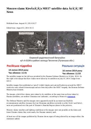
  • 1. Moscow slams Kiev’s MH17 satellite data — RT News Published time: August 01, 2014 10:27 Edited time: August 03, 2014 16:11 The satellite image on the left was provided by the Russian Defense Ministry on 14 July, 2014. On the right is the image that Kiev claims were taken by its satellites on July 16, 2014. Image from mil.ru Satellite images Kiev published as 'proof' it didn't deploy anti-aircraft batteries around the MH17 crash site carry altered time-stamps and are from days after the MH17 tragedy, the Russian Defense Ministry has revealed. The images, which Kiev claims were taken by its satellites at the same time as those taken by Russian satellites, are neither Ukrainian nor authentic, according to Moscow's statement. The Defense Ministry said the images were apparently made by an American KeyHole reconnaissance satellite, because the two Ukrainian satellites currently in orbit, Sich-1 and Sich-2, were not positioned over the part of Ukraine's Donetsk Region shown in the pictures. Moscow claims weather and lighting conditions in the images were not possible at the dates and times Ukraine claims they were made, the Russian ministry said. At least one of the images published by Ukraine shows signs of being altered by an image editor, the statement added.
  • 2. The ministry also criticized images published by Kiev to back its allegations that Russia smuggled heavy weapons over the border and shelled Ukrainian army positions. The images lack proper time stamps and coordinates, while Kiev didn't bother to explain why it believes that whatever vehicles are shown in them are Russian, the statement said. "It's the latest 'masterpiece' in the Ukrainian exercise in conspiracy theories, an attempt to divert responsibility," the ministry said. "It can take a deserved place next to other allegations against Russia voiced by Kiev that claimed that Russia was responsible for masterminding the Maidan protest and the tragedy in Odessa." "Apparently that's why the real owners of those photos are hesitating to publish them under their own name, since it would derail the myth of the omniscience of their space reconnaissance," the Russian ministry said. A comparison of satellite images published by Russia and Ukraine as presented by Kiev in an attempt to dispute the authenticity of Moscow's photos. The shadows are cast in different directions in the two images, proving that they could not have been almost at the same time two days apart, as indicated by the time stamps.
  • 3. The weather is also clearly different, with the Russian image showing a cloudy day, while the image presented by Kiev shows a clear day - showing that the images could not have been taken less than an hour apart, as claimed by the time stamps. The Russian military say the actual weather conditions at the time can be easily double-checked by independent sources.
  • 4. In another comparison with the images used by Ukraine, it was purposely degraded in quality in order to point out some irregularities. No such irregularities are present in the original image, the Russian military said. Malaysian Airlines flight MH17 crashed in Ukraine's Donetsk Region, which is engulfed by armed hostilities between Ukrainian troops and local militias. The plane was apparently shot down by a missile, although neither the type of missile nor who shot it has yet been properly established.
  • 5. As a troubled investigation into the tragedy, which claimed almost 300 lives, is underway, Kiev and some Western countries were quick to say that the militias and Russia were culpable for the deed. Kiev said it had no capabilities to take down the plane. The Russian Defense Ministry published satellite images and radar data, saying that evidence proved that Ukraine had both ground-based anti-aircraft batteries and military aircraft capable of firing an air-to-air missile deployed in the region on the day of the MH17 shoot-down. Some days later Kiev published its own set of images, claiming that those released by Russia were false. http://rt.com/news/177296-ukraine-mh17-satellite-images/