Sustainable Rural Tourism:Mizoram, India
•Transferir como PPT, PDF•
8 gostaram•1,652 visualizações

Strategies for development of sustainable tourism in Mizoram

Recomendados
Mais conteúdo relacionado
Mais procurados
Mais procurados (20)
Destaque
Destaque (20)
Semelhante a Sustainable Rural Tourism:Mizoram, India
Semelhante a Sustainable Rural Tourism:Mizoram, India (20)
Mais de Dhiraj Salhotra
Último
Último (20)
Sustainable Rural Tourism:Mizoram, India
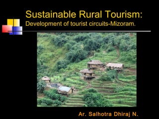
- 1. Sustainable Rural Tourism: Development of tourist circuits-Mizoram. Ar. Salhotra Dhiraj N.
- 2. North East India Introduction to North east India. Features of Mizoram. Scope for rural tourism in Mizoram. Current five year plan and its objectives for rural tourism. Strategy of tourist circuit development. Tourist circuits.
- 3. North East India It touches its border with China, Bhutan, Myanmar and Bangladesh and is connected to the rest of India by a 20 km wide ‘chicken neck’ corridor of land. This beautiful area of rolling forested hills and lush green lowlands has its head amongst the snow capped peaks of eastern Himalayas, with its feet touching the waters of the Bay of Bengal.
- 4. North East India: Eight States Assam occupies the lush lowlands of the Brahmaputra Valley Arunachal Pradesh occupies the densely forested and sparsely populated foothills of the Himalayas, Meghalaya, with its pine clad hills and lakes, is famous as the wettest region of the world. Nagaland has a rich war history that attracts tourists. Manipur, known as the ‘land of jewels’, Sikkim and Tripura make up a fascinating area consisting of green valleys, lush hills with variety of flora and fauna. Mizoram is beautiful area of rolling forested hills and lush green lowlands has its head amongst the snow capped peaks of eastern Himalayas, with its feet touching the waters of the Bay of Bengal.
- 5. Mystique: North East India "..This land is not like our land; its sky is not like our sky. It sends rain down without the originating cause of clouds; On its ground the green grass sprouts up without any aid from the soil. It stands outside the circle of the Earth and the bowels of the enveloping Sphere The seasons all begin here at the time of their conclusion elsewhere. Here there is heat in our winter and chill in our summer its roads are frightful as path leading to the Nook of Death; Fatal to life is its expense like the un-peopled City of Destruction. Its forests are full of violence like the heart of the ignorant. Its rivers are beyond limit and estimate like the minds of the wise…" Wrote Mullah Darvish of Herat in his accounts of his expeditions to the land bordering Northeast India.
- 6. Mizoram: "Land of the Highlanders". The Mizo Hills, dominate the state's topography, rise to more than 6560 ft near the Myanmar border. About three-fourths of the population earns their livelihood from agriculture. Small-scale irrigation projects are being developed to increase the crop yield.
- 7. Mizoram: "Land of the Highlanders". Physical Features: The state is covered by high mountains that 2000 meters high. Blue Mountain that 2165 meters. Climate: is temperate but pleasant. Flora and Fauna: is a storehouse of exotic flora and fauna.
- 8. Mizoram: “People". People: Sociable, hospitable and fun loving with very strong community bonds-the Mizos are often referred to as the ‘Songbird of the North east’. Ethnicity : They are of Mongolian origin, believed to have migrated from northwestern China. With the passage of time, a number of people with their own culture and tradition and belonging to diverse ethnicity have made the state their home . Arts and Crafts : The choice of bright color in everything is a unique facet of Mizo art and crafts.
- 9. Mizoram: “Culture and Music". Music and Dance : Cheraw Khuaflam, Chheih Iam, Musical instruments Shield drums "tingtang" (Guitar), a string instrument. "Phenglawng" (a flute)
- 10. Mizoram: “Culture and Festivals". Chapchar-Kut: A spring festival Mim-Kut & Pawl-Kut: to celebrate the completion of the harvesting season Thalfavang-Kut is celebrated after the completion of weeding of the land in preparation for the forthcoming harvesting season Christmas Christmas is one of the most important events of the Mizos
- 11. Mizoram: “Culture and Myth". Rihdil The end of every souls journey ‘…the soul before leaving the material world climbs up the Thasiama seno neihna step before diving in to the Rihdil lake for the final purification of the soul after which it eats the flower of its garden and bids forever…’ Mythical belief Thasiama seno neihna step Rihdil lake in Myanmar
- 12. TOURISM POTENTIALS Aizawl, is a religious and cultural centre of Mizoram. Champhai is a resort on the Myanmar border. Tamdil a natural lake with virgin forest is 60 km from Aizawl and 10 km from tourist resort of Saitual. Vantawng falls (137 km), five km from hill station Thezawl, are the highest and most beautiful waterfalls in Mizoram. The Museum and Mini Zoological Garden at Aizawl, Bung (picnic spot), and Paikhai.) and Champai (204 km) are some other picnic sites of the state.
- 13. Setbacks Northeast India today, lags behind in many areas of development, particularly in the area of revenue generation. The majority of the population of this region depends on agriculture and the forests for their livelihood, which is only of subsistence level with no knowledge or means for long- term benefits. The rich biodiversity of the region is also being drastically reduced due to the "Jhum Cultivation" (slash and burn cultivation) in the hilly areas. Most of the older generations possessing traditional knowledge have not been able to transfer it to the younger generation.
- 14. ECOTOURISM: A Solution Ecotourism appears to be a viable option for sustainable development and conservation of rich culture and environment of this region. Development of ecotourism in this fragile biotic and cultural situation will therefore be challenging. It would require innovative inputs. Its unfathomable beauty, cultural diversity and geographical location offer great potentials for and sustainable development for the entire region.
- 15. Need of the hour A comprehensive tourism action plan and marketing, which presents the Northeast as one destination, with tightly knit cooperation between all the northeast states. Planning the economic use of natural resources with the right inputs, tourism infrastructure project development and community participation to generate employment for local population. The various components of eco-tourism, such as the use of local materials and designs, use of eco-friendly techniques, proper waste management systems, recycling of garbage etc, should be made use of in schemes and projects.
- 16. The objectives for rural tourism in India, under the 10th Five year plan. To enhance the employment potential within the tourism sector as well as to foster economic development through developing linkages with other sectors. The focus under this scheme is on the improvement of existing product and developing new tourism products to world standard along with integrated infrastructure development of the tourist sites. Thrust is to promote village tourism as the primary tourism product to spread tourism and its socio- economic benefits to rural and its new geographic regions.
- 17. Southern and Eastern tourist circuit development To increase tourist traffic both national and international, also with interstate tourist can be promoted once the infrastructure and planned facilities are made available at various proposed locations. The sites for proposed developments as shown by Directorate of Tourism, Mizoram at various locations covered in this report have been inspected along with the official of State Tourism Department. The site and the requirements have been analyzed and complete conceptual scheme proposed accordingly.
- 18. Southern and Eastern tourist circuit development Southern Tourist Circuit Hrangchalkwan – Tawipui – Lawngtlai – Tuipang – Saiha – Vawmbuk – Sangau - S.Vanlaiphai Eastern Tourist Circuit Keitum- N.Vanlaiphai- E.Lungdar- Khawbung- Farkawn- Zokhawtar- Hnahlan- Saitual- Tamdil
- 19. Eastern tourist circuit Keitum- N.Vanlaiphai- E.Lungdar- Khawbung- Farkawn- Zokhawtar- Hnahlan- Saitual- Tamdil N.Vanlaiphai - It is located around 60 Kms away from Keitum, which itself is located around120 Kms to the south of Aizwal. E.Lungdar - It is located around 30 Kms away from N.Vanlaiphai, towards its North.
- 20. Eastern tourist circuit Keitum- N.Vanlaiphai- E.Lungdar- Khawbung- Farkawn- Zokhawtar- Hnahlan- Saitual- Tamdil Khawbung - It is located around 55Kms away from E.Lungdar, towards its South East side. Farkawn - It is located around 80 Kms away from N.Vanlaiphai, towards its North East. .
- 21. Eastern tourist circuit Keitum- N.Vanlaiphai- E.Lungdar- Khawbung- Farkawn- Zokhawtar- Hnahlan- Saitual- Tamdil Zokhawtar - Zokhawtar village is located near Champhai town at the border of Mizoram and Myanmar. Zokhawtar is also being developed as a Border trade center due to its strategic importance. The village is one of the most attractive place for tourist in the eastern part of Mizoram as the surrounding area has scenic views and the famous ‘Rih Dil’ lake near by across
- 22. Eastern tourist circuit Keitum- N.Vanlaiphai- E.Lungdar- Khawbung- Farkawn- Zokhawtar- Hnahlan- Saitual- Tamdil Hnahlan- - It is located around 60 Kms away from Champhai, towards its North East. Saitual- - It is located around 80 Kms away from Champhai, on route to Aizawl. .
- 23. Eastern tourist circuit Keitum- N.Vanlaiphai- E.Lungdar- Khawbung- Farkawn- Zokhawtar- Hnahlan- Saitual- Tamdil Tamdil - It is located around 40 kms away from Aizwal town on route between Champhai an aizwal.
- 24. Southern tourist circuit Hrangchalkwan – Tawipui – Lawngtlai – Tuipang – Saiha – Vawmbuk – Sangau - S.Vanlaiphai Hrangchalkwan - It is strategically located on the National Highway-54 to the south of Aizawl on route to Lunglei and the dividing junction for Lawngtlai and Lunglei. Tawipui - It is located between Lunglei and Lwangtalai, in the Lunglei district, almost 60 kms away from Hrangchalkwan.
- 25. Southern tourist circuit Hrangchalkwan – Tawipui – Lawngtlai – Tuipang – Saiha – Vawmbuk – Sangau - S.Vanlaiphai Lawngtlai - Is the head quarter of Lawngtalai district. – Tuipang - Tuipang is located in the Palak district, which is the southern tip of Mizoram,close to the bordering peaks of Myanmar.It is around 420 Kilometers to the south of Aizawl.
- 26. Southern tourist circuit Hrangchalkwan – Tawipui – Lawngtlai – Tuipang – Saiha – Vawmbuk – Sangau - S.Vanlaiphai Saiha - It is termed as the anglers paradise as Saiha is located on the Chhimtuipui River, Mizoram's biggest river. It is 378 Kms. Away from Aizawl, to the South. Phawngpui is only 30 Kms. Away from Saiha. Phawngpui is a National park melded to the Blue Mountain .
- 27. Southern tourist circuit Hrangchalkwan – Tawipui – Lawngtlai – Tuipang – Saiha – Vawmbuk – Sangau - S.Vanlaiphai Vawmbuk - It is the farthest point in the southern tourist circuit. It is from here the trekking route as a gateway to the Blue Mountain. It witnesses the peaks of Myanmar, from a strategic location, which overlooks the deep valleys and the peaks alike.
- 28. Southern tourist circuit Hrangchalkwan – Tawipui – Lawngtlai – Tuipang – Saiha – Vawmbuk – Sangau - S.Vanlaiphai Sangau - It is located on the route, which connects Tuipang to Lunglei via Zobawk. The site is a small town at a strategic location as a mid point to Saiha and Zobawk. It offers a base line to the journey towards the Mt.Phawngpui.
- 29. Southern tourist circuit Hrangchalkwan – Tawipui – Lawngtlai – Tuipang – Saiha – Vawmbuk – Sangau - S.Vanlaiphai S.Vanlaiphai - It is in proximity to the north of the Mt.Phwanpui, which makes it a strategic location. It is an alternative route to the Mt.Phwangpui to Vawmbuk in the south.
- 30. Achievements of tourist circuit development 1. To foster economic prosperity and conservation of the environment. 2. Improve as many lives as possible. 3. Ideally, it includes cooperation between Government, Non Governmental Organizations and the affected communities.