Potensi Pariwisata Singbebas
•
2 gostaram•1,682 visualizações

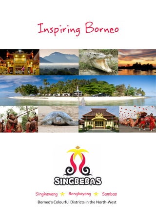
Singkawang City is located in West Kalimantan, Indonesia and has a population of 186,000 people. It has a large Chinese population and is known as the "City of 1000 Klenteng" due to the many Chinese temples. Singkawang hosts several cultural festivals throughout the year, most notably the Chinese Lantern Festival (Cap Go Meh) and the Islamic Lantern Festival (Keriang Bandong). It also lies near several beaches and mountains that provide opportunities for hiking.

Recomendados
Mais conteúdo relacionado
Destaque
Semelhante a Potensi Pariwisata Singbebas
Semelhante a Potensi Pariwisata Singbebas (20)
Mais de Pemerintah Kota Singkawang
Mais de Pemerintah Kota Singkawang (20)
Potensi Pariwisata Singbebas
- 1. Singkawang Bengkayang Sambas Borneo’s Colourful Districts in the North-West
- 2. Introduction to Borneo 4 (Photo: Nono Suprayitno) Cultural Diversity 6 (Photo: Dinas Sambas) Map with Destination Overview 8 (Photo: Thomas Ulrich) Singkawang City 10 (Photo: Nono Suprayitno) Bengkayang Regency 16 (Photo: Frans / Budpar) Sambas Regency 22 (Photo: Dinas Sambas ) Information about Singbebas Tourism 27 (Photo: Folder CGM 2011) 2
- 3. Welcome to North-West Borneo (Singbebas) Singbebas is the acronymic name given to the area of regional cooperation formed between the city administration of Singkawang, and the Regencies of Bengkayang and Sambas that have a combined population of 809,000. Bengkayang and Sambas share a border with Sarawak in Malaysian Borneo and, as such, form the northern triangle of West Kalimantan. The international airport at Pontianak has direct flight connections to Singapore, Kuching, Jogjakarta, Batam and Surabaya and 16 daily flights to Indonesia’s capital city of Jakarta. Visitors arriving at Pontianak and travelling further to Singbebas will cross the equator marked by the Tugu Khatulistiwa (The Equator Monument) located seven kilometres north of Pontianak, which is also home to a small museum. The area’s climate is tropical, making it hot and humid in lowland areas, but more moderate at higher elevations. Temperatures fluctuate little over the course of the year with an average low at sea level of 23° C and the average high is 32° C. June, July and August are the driest months, while more rainfall occurring during the remainder of the year, with November being the wettest month. Singbebas’ amazing cultural diversity derives from its indigenous Dayak tribes and the Malay and Chinese who are relative newcomers to the area. Each of these groups has their own unique tradition of festivals and ceremonies that tourists are welcome to enjoy. The city of Singkawang, with its majority ethnic Chinese population, is known as a centre of Chinese culture in Kalimantan. Singkawang also offers many beach attractions catering to domestic visitors, while the surrounding mountains provide attractive opportunities for nature loving enthusiasts. Singkawang is well known for its annual Chinese lantern festival (Cap Go Meh) celebrated during the first full moon of the each lunar year. In Bengkayang Regency visitors can enjoy nature and culture tourism attractions such as the many waterfalls and the large protected rainforest areas of Mount Niut, the highest peak in Singbebas, where a genuine Borneo jungle adventure awaits adventurous visitors. Bengkayang is also starting point to experience Bidayu Dayak villages such as Sebujit, where a large annual harvest festival is held. At Randayan Island visitors can enjoy an isolated tropical paradise surrounded by rich coral reefs. In Sambas Regency an uninterrupted 42-kilometer-long sand beach between the Paloh River and the village of Temajuk remains largely virginal, offering an endless succession of bays and small capes set against a lush rainforest backdrop facing a clear and pristine sea. Home to what is believed to be the longest and most unspoilt sand beach in Southeast Asia, the beach at Sambas is also known as one of the world’s major nesting places for threatened sea turtles. Also not to be missed at Sambas is the Sultan’s palace that houses a small museum. xxxxxxxxxxxxxxxxxx xxxxxx of the West Kalimantan Province Kuala Lumpur Kuching Singapore 0° 0° Sumatra Pontianak Kalimantan Sulawesi (Photo: Thomas Ulrich) Jakarta Java Bali Statue at the Equator Museum 7 km north of Pontianak wikitravel.org/en/West_Kalimantan 3
- 4. Introduction to Borneo With an area of 743,330 square kilometres - an area more than twice the size of Germany, Borneo is the third largest island of the world. Borneo is located at the centre of Southeast Asia and includes the territories of 3 countries: Indonesia (73%), Malaysia (26%) and Brunei (1%). Kalimantan is the Indonesian name for the island of Borneo. Kalimantan is known for its 130 million year old rainforest and its more than 15,000 species of flowering plants, 3,000 species of trees, 221 species of terrestrial mammals and 420 species of birds. The Borneo rainforest is also the natural habitat for the Borneo orang-utan, Asian elephant, Sumatran rhinoceros and the Borneo clouded leopard. Once covered by a pervasive rainforest, the total area of forested jungle has now shrunk due to heavy logging and the introduction of palm oil plantations that are encroaching on the last remnants of primary rainforest. The endemic rainforest is also being destroyed by forest fires, many started by local farmers clearing forested lands for crop cultivation. (Photo: Volker Kess) According to ancient Chinese, Indian and Javanese manuscripts, the western coastal cities of Borneo were already established as trading ports during the first millennium. In the 14th century, almost all coastal parts of Borneo fell under the control of a Javanese Majapahit kingdom that referred to the island as “Nusa Tanjungnagara”. During World War II (1941-1945), Japanese forces gained control of Borneo. Local populations were decimated and numerous Malay intellectuals were killed. Australian allied forces liberated Borneo from the Japanese in 1945. 12 years after the proclamation of Indonesian independence in (Photo: Junaidi) 1945, Kalimantan was divided into three provinces and in 1957 and a year later in 1958 into four provinces. Borneo was the centre of Indonesia’s political and armed opposition to the creation of Malaysia during the “Konfrontasi” of 1962-1966. Rafflesia flowers may reach over 100 centime- tres in diameter, and weigh up to 10 kilograms . According to Indonesian and Malaysian censuses in 2010, Borneo had The flower is named after Sir Thomas Stamford 19.8 million inhabitants (26 inhabitants per square kilometer) with most Raffles, the leader of the expedition that first of the population congregated in coastal cities, with the hinterlands described it. populated by small towns and villages located along the island’s river- banks. The island’s population consists of traditional Malays (including Banjar and Bugis), Chinese and indigenous Dayak ethnic groups. (Photo: Bobby Bong) (Map: Nono Suprayitno) 4 wikitravel.org/en/West_Kalimantan
- 5. Introduction to Borneo (Photo: Nono Suprayitno) Rivers still are a major means of transport for large parts of the population of West Borneo Introduction to West Borneo With an area of 146,760 square kilometres - roughly equivalent in size to Nepal, West Kalimantan is home to a population of 4.4 million people, divided among the three main ethnic groups. The Chinese, representing (Photo: Frans / Disbudpar) 17% of the population, migrated in past times from south-eastern China, with many families now in their 7th generation on the island. Prior to the 17th century, the native Dayaks represented the main inhabitants of West Kalimantan, while today the Malay population forms the majority of the the population. During the Japanese occupation, an estimated 21,000 peo- ple (including sultans, nobleman, commoners, women and children) were kidnapped, tortured and massacred by Japanese troops. Tambah Malay With the end of the regional ethnic conflicts between the indigenous Dayak people and migrants from the island of Madura, that raged from (Photo: Disdbudpar) 1996 until 2001, Kalimantan is today considered as a safe destination for both travellers and residents alike. wikitravel.org/en/West_Kalimantan 5
- 6. Cultural Diversity Cultural Diversity Dayak culture The Dayak are the aboriginal people of Borneo. The tribal name of “Dayak” refers to more than 200 riverine and hill-dwelling ethnic subgroups occupying the interior of Borneo. Although all ethnically Dayak, each of these groups possesses its own dialect, customs, laws, home territory and culture. In time’s past, the animistic Dayak were feared for their ancient tradition of headhunting. After conversion to Christianity and Islam anti-headhunting legislation was introduced by colonial rules precipitating the gradual disappearance of this gruesome tradition. Traditionally, Dayak agriculture was based on slash and burn shifting rice cultivation techniques. As a result, agricultural land was largely limited to hillside rice farming and forest plots. These days approximately 90% of Dayaks are Christian, a religion introduced by missionaries in the 19th century. Under Indonesia's transmigration program, farmers from densely populated areas in Java and Madura were encouraged to settle in the Indonesian provinces of Borneo. Under Indonesia's transmigration program, farmers from densely populated areas in Java and Madura were encouraged to settle in the Indonesian provinces of Borneo. This large-scale transmigration, however, resulted in social tensions and violent conflicts causing the Indonesian government officially ended the transmigration program in 2001. Malay culture The Malay race are an Austronesian people who inhabit the Malay Peninsula, (Photo: Frans / Disbudpar) Sumatra, the southernmost parts of Thailand, Burma’s southern coast, coastal Borneo - including Brunei, West Kalimantan, coastal Sarawak and Sabah, and the smaller islands that lay between these locations. The golden age of Malay sultanates dating from the 15th century, introduced the foundations of a common Malay identity based on language, Islamic belief and cultural traditions. The Sultanate of Brunei ruled a large part of northern Borneo from the 15th to 17th century. By the 18th century, the area from Sambas to Berau became vassals of the (Photo: Frans / Disbudpar) (Photo: Jomandi Loka) 6
- 7. Cultural Diversity (Photo: Dispudbar Sambas) (Photo: Nono Suprayitno) By the 18th century, the area from Sambas to Berau became vassals of the Banjar Kingdom, which under the reign of Prince Nata Dilaga (1808-1825) relinquished its territories, including Sambas, to the Dutch East Indies. During the 19th century, the Dutch established their own district kingdoms, installing native leaders who owed their allegiance to the colonial government. Chinese culture (Photo: Dispudbar Sambas) Successive waves of Chinese emigration to Sambas were driven by wars and starvation taking place in mainland China. Most immigrants were illiterate farmers and laborers, historically known as “coolies.” The sultans of Western Borneo imported Chinese laborers in the 18th century to work in gold or tin mines. In Singkawang and Sambas the first major Chinese mining settlements dates from around 1760. Some of these mining settlements managed to gain a degree of political autonomy, such as the Lanfang Republic that existed from 1777 until its end in 1884, when the Dutch took control in an action recorded as breaking up of a "Chinese uprising". The Chinese descendants, known as “Tionghoa”, who initially settled across the Singbebas region, remain there today seven generations later. The Sin Min ritual is part of the Cap Go Meh festival during the Chinese new year celebrations (Photos: Nono Suprayitno) 7
- 8. Map with Destination Overview 8 wikitravel.org/en/West_Kalimantan
- 9. Map with Destination Overview wikitravel.org/en/West_Kalimantan 9
- 11. Singkawang City Singkawang City Singkawang City, with a population of 186,000, is the visitor gateway for those arriving overland from Pontianak or Kuching. The name ‘Singkawang’ is believed to derive from the Hakka Chinese phrase, “san khewjong” that translates as “a town in hills nearby the sea and an estuary.” Singkawang offers a good range of hotels and restaurants located in the city centre and along the city’s beachfront. Singkawang has the highest proportion of ethnic Chinese population among all Indonesian cities, a fact reflected in its reputation as the “City of 1000 Klenteng” (Chinese temples). (Photo: Disdbudpar) Chinese Lantern Festival The Cap Go Meh festival takes place 15 days after the Chinese New Year and marks the end of each year’s Chinese New Year celebrations. Local tradition dictates that the Chinese New Year should be celebrated during the first full moon of the lunar year marked by the hanging of thousands of colourful lanterns. During this festive time, people enjoy trying to solve mysteries and riddles painted on lanterns, eat yuan xiao (glutinous rice balls), and, most importantly, enjoy family reunions. The colourful lanterns are symbolic of good luck and hope. (Photo: Disdbudpar) Cheek piercing with sharp objects is a ritual of purification and to invoke the spirits. This is part of the street procession called Sekong Mun (Photo: Disdbudpar) Cap Go Meh (Photo: Nono Suprayitno) wikitravel.org/en/Singkawang 11
- 12. Singkawang City Keriang Bandong Keriang Bandong is a tradition linked to the Islamic fasting month of Ramadan that sees families illuminate their front yards and streets with traditional bamboo oil lamps. With the passage of time oil lamps gave way to lanterns that nowadays have yielded to electrical lights. These lanterns are usually mounted in the yards of the houses on the night of Lailatul Qadr (21st night of the fasting month) and remain in place until Eid-ul-Fitr, the Muslim High Holiday that marks the end of Ramadan, the Islamic holy month of fasting. It is believed that during the night of Lailatul Qadr angels descend to earth, necessitating that all houses must be clean and illuminated as a sign of welcome. The Singkawang Keriang Bandong has evolved to become a festival with nightly lantern and music street parades. Lantern street parade during Keriang Bandong, a tradition linked to the Is- lamic fasting month of Ramadan (Photos: Iwan / Disbudpar 12 wikitravel.org/en/Singkawang
- 13. Singkawang City (Photo: Iwan / Disbudpar) Traditional performances of the Dayak Salako tribe during the Ngabayotn harvest festival Ngabayotn - Harvest Festival Ngabayotng is a ritual ceremony of the Dayak Salako tribe held in the traditional village of Bagak Sahwa, Singkawang. Set among beautiful local landscapes, the ceremonies last for 3 to 4 days starting May 29 with the peak of the festivities on June 1st. Ritual offerings are made in the houses of the villagers, who sacrifice chickens, pigs and tradi- tional rice cakes to thank the gods and ancestors for the harvest and to (Photos: Nono Suprayitno) ask for a prosperous start of the coming planting season. The festival The peak of the Ngabayotn harvest festival is on June includes the performances of traditional games such as spinning of 1st with ceremonies held in the traditional community tops and slingshot matches. Traditional music and dances, pandan house (rumah adat) in the village of Bagak Sawa leave basket weaving and rice husking competitions also form a part of the festivities. (Photo: Iwan / Disbudpar) wikitravel.org/en/Singkawang 13
- 14. Singkawang City Singkawang Mountains and Beaches Singkawang is surrounded by mountains: Mount Poteng (660 m), Mount Raya (920 m) Mount Passi (780 m) and Mount Sari (280 m). Hiking trails lead up to the peaks of these mountains where nature lovers can enjoy the rainforest and occasional aromatic encounters with the, rare Rafflesia Arnoldii flower - the largest individual flower on earth. While all of the Singkawang mountain can be climbed as day trips, a recommendable alternative is to combine the climb of Mount Poteng and Mount Raya in a two day trekking. The most un- touched and rewarding rain forest can be experienced while climb- (Photo: Nono Suprayitno) ing Mout Raya or Mount Passi. At Mount Raya there is a high likeli- hood to see gibbons (Müller's Bornean gibbon). (Photo: Thomas Ulrich) (((((Photo: Junaidi) (((((Photo: Yoga B. ) ((((((Photo: Bobby Bong) 14
- 15. Singkawang City (Photo: Nono Suprayitno) Pasir Panjang, one of the many beaches of Singkawang Numerous wide sand beaches are to be found along the coastline, north and south of Singkawang city. However, due to the many rivers flowing from the interior of Kalimantan a large quantity of dissolved soil is carried into the sea causing the sea water along these beaches to be cloudy for much of the year. Long Beach or Pasir Panjang is the main beach of Singkawang and can be easily reached in 20 minutes from the city centre. Visitors can enjoy a day trip or pause for a longer stay at the Beach Hotel. The hotel has (Photo: Nono Suprayitno) a large swimming pool that is open to the public, as well as meeting room facilities. Restaurants and a large number of local food stalls are in close proximity as are a range of sports, such as banana boat and flying fox rides. For detailed information on attractions, activities, accommodation, lo- cal transport and other travel practicalities please visit: wikitravel.org/en/Singkawang (Photos: Thomas Ulrich (Photo: Nono Suprayitno) wikitravel.org/en/Singkawang 15
- 16. Bengkayang Regency Bengkayang Regency The Bengkayang Regency has a population of 215,000 with the region’s capital at Bengkayang, a city located in the interior at an altitude of 160meters above sea level, about 90 kilometres east of Singkawang. The regency stretches from the border of Sarawak in the east down the coastline, south of Singkawang City. The majority of the population are indigenous Dayaks. Waterfalls The hinterland of Bengkayang is largely untouched by modernity making the region particularly inviting to nature lovers. Bengkayang offers waterfalls in abundance set in beautiful rainforest settings. Among the most impressive is Barawatn, 84 meters high with an inviting natural swimming pool at its base. To get there drive from Bengkayang towards Seluas, turn right at the village of Sahan. From Sahan follow the road until Melayang Pangkok. From there follow the hiking trail to the waterfall (30 minutes). Along the path hikers will get a glimpse of the daily life of villagers and farmers. Local children eagerly accompany visitors on their walk to (Photo: Yoga B. Handoko) the waterfall. Bromheadia finlaysoniana is an orchid with a flower size of 8 cm and grows in open dry spaces and in low land forests (Photos: Frans / Disbudpar) (Photo: Jomandi Loka) Barawatn, 98m high is the most impressive of the many waterfalls in Bengkayang (Photo: Frans / Disbudpar) 16 wikitravel.org/en/Bengkayang
- 17. (Photo: Bobby Bong) Arriving at Randayan Island resort, a perfect retreat for travelers who like to spend some days on a secluded island Randayan Island (Photo: Bobby Bong) Randayan Island, located 17 kilometres offshore from Sungai Raya, it is the smallest and probably the most beautiful among a group of islands, measuring only 450 meters in length and an average 250 meters wide. Two-thirds of its shoreline is comprised of white sandy beaches where visitors can snorkel. Nature enthusiasts might observe green or hawksbill turtles laying eggs on Randayan Island during the annual hatching season of May to August. Boats to Randayan are available at Teluk Suak, 24 kilometres south of Singkawang. A bungalow resort allows overnight stays and offers delicious fresh seafood. The resort also offers diving equipment for rent, but no licensed dive master is available. Cristal clear water and amazing coral reefs await visitors to Randayan Island. (Photos: Thomas Ulrich) wikitravel.org/en/Bengkayang 17
- 18. Bengkayang Regency Mount Niut Rainforest With an altitude of 1,687 m above sea level Mount Niut is the highest peak of Singbebas and is located in the heart of the largest rain forest area of the region. Adventurous visitors can climb to the peak of Mount Niut during a 2-3 day trek. The forest is home to an isolated and small population of orangutans and a larger population of gibbons (Müller's Bornean gibbon). These gibbons are masters of swinging from branch to branch for distances of up to 15 meters at speeds as fast as 56 kilometres per hour are the fastest and most agile of all apes. They defend the boundaries of their territory with vigorous visual and vocal displays. The gibbon’s Indonesian name “Owa-Owa” refers to the very loud duet sung by a mated pair and can be often heard in the distance while trekking in the Niut forest. The extremely rich flora and fauna of this region provides for a real Borneo jungle adventure that can only briefly be highlighted in this brochure. Travellers might be able to spot orangutan sleeping nests high up in the trees but only a lucky few will actually see them in their natural habitat. Orangutans prefer to feed on fruits, favouring the aromatic Durian, but they also eat vegetation, (Photo: Thomas Ulrich ) View from the peak of Mount Niut over the vast rain forest area (Photo: Chien C. Lee) (Photo: Chien C. Lee) Müller's Bornean gibbons are masters of swinging from branch to branch for distances of up to 15 me- ters . (Photo: Frans / Disbudpar) 18 wikitravel.org/en/Bengkayang
- 19. Bengkayang Regency ((Photo: Thomas Ulrich) (Photo: Yoga B.) The peak of Mount Niut is lo- The beautiful Mahogany frog is cated in the in the largest rain just an example of the extremely forest area of Bengkayang. rich fauna that awaits visitors. (((Photo: Frans / Disbudpar) Ask your trekking guide also to show you the many types of Nepenthes, also popularly known as tropical pitcher plants or “monkey cups” - be- cause monkeys have been observed drinking rainwater from these plants. Pitcher plants are carnivorous, possessing a deep cavity filled with liquid known as a pitfall trap. Insects are attracted to the cavity by visual lures (pigments) and sweet nectar. The starting point for a jungle trek in this region is in the village of Dawar, 77 kilometres from Bengkayang. Drive from Bengkayang to Sanggau Ledo, turn right and drive up to the end of the narrow but paved road in Dawar. Ask the village head in Dawar to make arrangements for guides and porters. The most experienced guide is Pak Ajam. On the day of arrival climbers can either stay in the village or hike to the base camp hut 90 minutes above Dawar located at the edge of the forest. Trekkers need to bring along their own outdoor equipment, including tent, mattress, sleeping bag, stove and a strong mosquito repellent for shoes, socks and legs in order to keep leeches away. Hardcore adventurers can cross the mountain range and descend to the east side until you finally reach Entikong by long boat. This trip requires 4-5 days and participants need to be prepared to traverse tough and difficult terrain. It is essential to hire a guide who has done this trip before. (Photos: Yohanes Kurnia Irawan) Tropical pitcher plants or “monkey cups” . The greatest diversity of these carnivorous plants occurs in Borneo with many endemic species. (Photo: Yoga B.) wikitravel.org/en/Bengkayang 19
- 20. Bengkayang Regency Dayak Village Sebujit The Bidayuh Dayak form one of the major Dayak groups in West Kalimantan and are the second largest Dayak group found in nearby in Sarawak, Malaysia. The village of Sebujit is located 72 kilometres northeast of Bengkayang. From Bengkayang it takes 1.5 hours by car to Seluas. From there, the most scenic access to Sebujit is by longboat, a trip that takes another 1.5 hours. At low water levels (usually July/August), the access by longboat is not always possible, leaving the alternative route from Seluas to Sebujit by motorbike taxi. Every year a major harvest festival called Gawai is celebrated on the 15thof June. The festival lasts for a total of 7 days and is believed to be the largest festival of its kind in Borneo, attracting guests and visitors from Bidayuh Dayak (Photo: Marathon Siregar) villages in both Sarawak and West Kalimantan. During the Gawai festival traditional games as well as traditional music and dances are performed. Visitors staying in Sebujit in periods outside of the Gawai festival can be introduced to the use of blowpipes or witness village rituals such as the upside-down bamboo stem climbing, normally performed by a husband whose wife is in an advanced stage of pregnancy. Local belief holds that the wife of any man successfully performing this ritual will experience an easy birth. At Sebujit visitors can stay in basic but well-designed bamboo chalets. For detailed information on attractions, activities, accommodation, transport (Photo: Frans / Disbudpar) and other travel practicalities please visit: wikitravel.org/en/Bengkayang A Bidayuh hunter loading his blow-pipe (Photos: Frans / Disbudpar) Part of the Gawai festival is the ritual bathing of human skulls called Nyobeng. The skulls are stored in an elevated barn called “Baluk”, positioned about ten meters above the ground. Nyobeng was traditionally practiced by pagan Bidayuh to welcome warriors returning from headhunting expeditions. The skulls are stored in an elevated barn called “Baluk,” positioned approximately 10 meters above the ground 20 wikitravel.org/en/Bengkayang
- 21. (Photo: Yoga B. Handoko) 21
- 22. Sambas Regency (Photo: WWF Indonesia) The mosque of the Keraton Samnbas, built entirely from ironwood with a Javanese style multi-level roof Sambas Regency The Sambas regency has a population of 496,000 and forms the northernmost part of Singbebas. The city of Sambas is historically known for its Sultanate that once controlled a large part of the coastal area of West Kalimantan. Sambas shares a long common border with the Malaysian state of Sarawak. Keraton Sambas - Sultan’s Palace The sultan’s palace is beautifully situated at the junction of 3 rivers: little Sambas river, Teberau river and Subah river. The original palace in this location was built by Sultan Muhammad Tajuddin I (Raden Bima) who reigned from 1668-1708. The current palace building dates from the reign of Sultan Muhammad Mulia Ibrahim Shafiuddin who ruled Sambas from 1931-1944 and who was executed by the Japanese occupation forces in 1944. The graveyard of the Sultan is located nearby the palace and is locally known as Makam Sultan Mohammad Tsafioedin. The palace is entirely constructed from ironwood, golden yellow is its dominant architectural colour. The complex includes a mosque, built entirely from ironwood in 1885, in a syncretic Javanese mosque style using a tall, multi-level timber roof instead of the more globally ubiquitous Islamic dome. (Photo: Thomas Ulrich) The palace can be visited free of charge and hosts a collection of regalia, historic photo- graphs and furniture . (Photo: Thomas Ulrich) (Photos: Disbudpar Sambas) 22 wikitravel.org/en/Sambas
- 23. Sambas Regency Paloh River and the Spirits of Batu Bejamban A boat tour, taken either in the early morning or afternoon hours, allows visitors to view the flora of the mangrove ecosystem and a sampling of the regions rich fauna such as proboscis monkeys (Nasalis larvatus), smooth otters (Lutrogale perspicillata), and saltwater crocodiles (Crocodylus porosus), the largest of all living reptiles. The boat tour combines beautifully with a visit to the mystical site of Batu Bejamban that literally means “a stone that never becomes dry.” Considered locally to be a holy spring, this stone boulder has two major holes: one that is thought to connect to the Sultanate of Brunei and the other one to the Sultanate of Sambas. It is believed until this day that a former Paloh kingdom was located at Batu Bejamban, but all of a sudden went into decline and disappeared after a boat crew failed to ask for permission to attach the rope of their boat at Batu Bajamban. To the Chinese, Batu Bejamban is believed (Photo: Chien C. Lee) to be a place of mystical power that brings unconditional fortune to the visitors. For the Malays, Batu Bejamban is a place to pray and make a wish to become a place of pilgrimage once those wishes are fulfilled. Boats for this trip can be arranged at the food stalls on both sides of the Paloh river ferry crossing. (Photos: WWF Indonesia) (Photo: Chien C. Lee) The saltwater crocodile is the largest of all living reptiles. (Photos: Thomas Ulrich) To the Chinese, Batu Bejamban is believed to be a place of mystical power. wikitravel.org/en/Sambas 23
- 24. Sambas Regency Temajuk Village and Cape Datu Since July 2012 the village of Temajuk has been accessible by car. Because the road is still partly under construction, travellers should prepare for a rough ride, although a four-wheel drive vehicle is not necessary. A more beautiful and exotic mode of access is by motorbike taxi along the long beach at low tide. Motorbike taxis are available in Paloh or Sebubus. The village of Temajuk is located at the western base of Cape Datu, around (Photo: Thomas Ulrich) 44 km north of the Paloh river ferry crossing. Farmers and fishermen first started to settle in this isolated location bordering with Sarawak some 40 years ago. Go for a beach stroll to enjoy the amazing rock formations and secluded sand beaches north of the village or take a hiking trip to the mountain ridge to observe monkeys, hornbills, and other diverse forms of flora and fauna. Nature lovers should not fail to arrange a trekking trip from the Cape Dato lighthouse back to Temajuk. A local boat at Temajuk harbour can be rented and will drop visitors at a small beach at the cape. From the boat landing follow the hiking trail up to the lighthouse. From there the trail continues (Photo: Public domain) along the mountain ridge to a scenic vantage point on top of a giant stone boulder called “Batu Bajulang” at 450 meters above sea level. From this location enjoy breathtaking views to the east (Sarawak, Tanjung Dato National Park) and the west coast. The trail follows the mountain ridge back to Temajuk. A variety of monkeys can be seen and the many hornbill birds, such as the majestic rhinoceros hornbill, can be heard along this trip of 6-7 hours utilizing a well-defined hiking trail. Depending on luck and season, guides might point out a Rafflesia flower, the official state flower of Indonesia and named after Sir Thomas Stamford Raffles, the leader of the expedition who first described the flower to western science. (Photo: Thomas Ulrich) It is possible to spend a night with the lighthouse guardians and to observe the birdlife and incredible sunsets from the observation platform. Less adventurous visitors can enjoy the return trip to the lighthouse by boat. In Temajuk visitors can stay at a guesthouse called “Pondok Wisata” offering very basic facilities located 4 km north of the village in a beauti- ful beachside setting. Local hosts can arrange a seafood barbeque at the beach providing an order is placed well in advance. (Photo: Thomas Ulrich) Delicious fresh seafood arriving at Te- majuk harbor (Photo: S. Hendratno / WWF) 24 wikitravel.org/en/Sambas
- 25. ((Photo: S. Hendratno WWF Indonesia) The Longest Beach (Photo: Thomas Ulrich) The 42 km long sand beach stretches from the Paloh River crossing in the south and ends north of the village of Temajuk. This beach is still in pristine condition and is comprised of an endless succession of bays and small capes with a rainforest backdrop and perfectly clear water. This is believed to be the longest (uninterrupted) and most untouched sand beach in Southeast Asia. The beach is a major nesting place for four species of sea turtles, the (Photo: S. Hendratno WWF Indonesia) ones most often seen are: The green sea turtle (Chelonia mydas), is listed as endangered and can be found in tropical and subtropical seas around the world. The average weight of mature individuals is 130 kilograms and the average length is 1 meter. The adults commonly inhabit shallow lagoons and feed (graze) mostly on sea grasses. The hawksbill sea turtle (Eretmochelys imbricate) is a critically endangered sea turtle that lives in tropical coral reefs and feeds on sea sponges, algae, jellyfish and sea anemones. It grows up to 1 meter in length, weighing an average 80 kilograms. WWF Indonesia has started its first sea turtle conservation project in this area in 2009 aiming at the conservation of sea turtles and their habitat. Visitors eager to observe the sea turtles are advised to report to the very helpful staff at the WWF office in Sebubus, Paloh District. . (Photo: Frans Dinsbudpar Bengkayang) wikitravel.org/en/Sambas 25
- 26. Sambas Regency (Photo: S. Hendratno / WWF Indonesia) Beautifully decorated traditional model boats filled with offerings are ready to be released Antar Ajung Planting Ceremony into the sea to ask the gods and spirits for a good rice planting season Antar Ajung literally means “to bring a boat” and is a ceremony held at the start of the rice planting season to pray for a good future harvest. For this ceremony villagers build beautifully decorated small boats that are filled with offerings such as coconut oil and yellow rice that are released into the sea. The model boats are up to 40cm wide and 4m long and are (Photo: Agri Aditya / WWF Indonesia) faithful copies of traditional sailing boats. The night before the release of the boats a ritual is held by the traditional village leader. The ceremonies also include traditional games, dances and music performances. Antar Ajung ceremonies take place from June - August in coastal villages of the districts of Tangaran dan Kecamatan Paloh. The biggest ceremony is held at the village of Arung Parak about 20 kilometres south of Paloh. (Photo: S. Hendratno / WWF Indonesia) (Photo: Hendro Susanto / WWF Indonesia) 26 wikitravel.org/en/Sambas
- 27. Information about Singbebas Tourism More information about Singbebas tourism: Internet sources: Online travel guide West Kalimantan: wikitravel.org/en/West_Kalimantan Online travel guide Singkawang: wikitravel.org/en/Singkawang Online travel guide Bengkayang: wikitravel.org/en/Bengkayang Online travel guide Sambas: wikitravel.org/en/Sambas Online travel guide Temajuk: wikitravel.org/en/Temajuk Online and GPS map downloads: www.openstreetmap.org or www.navigasi.net/goptd.php Satellite maps and pictures: Google Earth with Panoramic pictures Official tourism offices: West Kalimantan (Pontianak) Provincial Government Culture & Tourism Office in Pontianak, Jl. Letjen Sutoyo No. 17, Phone: +62 561 742 838, open Mo-Fri 07:00-15.00 Singkawang: City Tourism Office in Singkawang, Jl. Fridaus No. 1 Phone: +62 562 631 423, open Mo-Fri 08:00-16:00 Bengkayang: Regency Government Tourism Office in Bengkayang Jl. Guna Baru Trans Rangkang, open Mo-Fri 08:00-16:00 Sambas: Regency Government Tourism Office in Sambas, Jl. Pembangunan, Phone: +62 562 391 802, open Mo-Fri 08:00-15:00 Acknowledgments This tourism profile brochure has been compiled through the support provided by the Regional Economic Development (GIZ-RED) programme for Singbebas, West Kalimantan commissioned by the German Federal Ministry for Economic Cooperation and Development (BMZ). Intended to assist in the development of tourism, this publication represents the efforts and inputs of stakeholders from the regencies of Sambas and Bengkayang and the city administration of Singkawang, expert consultants, and provincial officials - particularly from the BAPPEDA and the Tourism Service; and the people of the Singbebas region who have contributed valuable information used in preparing this brochure. We wish to thank the contact persons of the tourism services (Dinas Pariwisata) who organized and provided information and pictures of the attractions: Mr. Supardiana and Mr. Iwan (Singkawang), Mr. Zulfan and Mr. Herizal (Sambas) and Mr. Mustaqim and Mr. Frans Wijaya (Bengkayang). Special thanks to Mr. Sumastro from BAPPEDA Singkawang and to Mr. Sukari, head of tourism working group Singbebas, for their tremen- dous support to make the inter-district cooperation of Singbebas a success. Many thanks to the WWF team in Paloh who supported us in the field assessments, provided their office as a base camp and contributed their knowledge as well as pictures. Special thanks to all photographers who contributed excellent pictures without charge in order to support the success of Singbebas tourism. (Photographers are credited below the pictures). Thanks also to the team of GIZ-RED in West Kalimantan for their help in bringing this brochure to fruition. Finally, great thanks are due to all the people and development stakeholders in the Singbebas region for their friendship, frankness and openness that permitted this publication’s completion. Field assessments, concept, text and coordination: Thomas Ulrich Tourist map: Chandra Wijaya Graphic design and picture editing: Volker Kess Text editing and proof reading: John M. Daniels 27
- 28. Volker; Bitte die Reihenfolge der Logos so ändern dass Singkawang (links) Bengkayang (rechts) und Sambas (links) angeordnet sind Working together for the success of North-West Borneo Tourism through regional cooperation 28