Spatial modelling of multiple pressures to support the implementation of the MSFD and MSP

We present two different approaches to study human pressures within the context of the Marine Strategy Framework Directive (MSFD) and further developments on Maritime Spatial Planning (MSP). The first approach considers a single driver or sector (ie., maritime transport) and its relation to multiple pressures and their relationship with descriptors from MSFD. We use data of automated identification systems (AIS) and highlight the potential applications of this new source of data. The second approach integrates multiple drivers, which results in multiple pressures, into an integrative cumulative index. The study area is the Gulf of Lyon (NW Mediterranean), as a trans-boundary case study developed in the FP7 project KnowSeas. The results obtained highlight the potential of both approaches to be used in different steps of the MSFD.

Recomendados
Mais conteúdo relacionado
Destaque
Destaque (19)
Último
Último (20)
Spatial modelling of multiple pressures to support the implementation of the MSFD and MSP
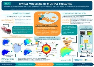
- 1. SPATIAL MODELLING OF MULTIPLE PRESSURES 2104 TO SUPPORT THE IMPLEMENTATION OF THE MARINE STRATEGY FRAMEWORK DIRECTIVE (MSFD) AND MARINE SPATIAL PLANNING (MSP) DAVID MARCH (IMEDEA-CSIC: david@imedea.uib-csic.es), CARLA MURCIANO (Plan Bleu), JOAN ALBAIGÉS (IDEA-CSIC), RAFAEL SARDÁ (CEAB-CSIC), JOAQUIN TINTORÉ (IMEDEA-CSIC, SOCIB) CUMULATIVE PRESSURES MARITIME TRAFFIC ONE DRIVER, MULTIPLE PRESSURES MOTORWAYS OF THE SEA MULTIPLE DRIVERS, ONE INDEX • IMPORTANT ROLE IN THE WORLD TRADE AND ITS ECONOMIC DEVELOPMENT • ENCLOSED SEA SUCH AS THE MEDITERRANEAN PARTICULARLY VULNERABLE •PRESSURES RELATED TO MSFD DESCRIPTORS: BIODIVERSITY, ALIEN SPECIES, POLLUTION, LITTER, NOISE HOLISTIC APPROACH CASE STUDY: GULF OF LYON AIS: AUTOMATED IDENTIFICATION SYSTEMS - REGISTER THE POSITION OF COMMERCIAL SHIPS - WE DEVELOP A SYSTEM TO STORE, MANAGE, ANALYSE AND VISUALIZE AIS DATA USING POSTGIS AND R. - WE GENERATE DIFFERENT GRIDDED PRODUCTS TO REPRESENT RELATED PRESSURES USING GIS PRESSURE MAPPING • TRANS-BOUNDARY CASE STUDY (TWO EU COUNTRIES) • MARINE SPATIAL DATA INFRASTRUCTURE, CONTAINING: + PHYSICAL SYSTEM + BIOLOGICAL SYSTEM +HUMAN SYSTEM 57 WWTP 208 OIL SPILLS 8 MAIN PORTS 45,000 MOORINGS 69 MARINAS 236 SCUBA SPOTS 7,000 PORT TRANSITS 310 BATHING SITES 20 MT FISH CATCHES •GOOD ENVIRONMENTAL STATUS OF MARINE ENVIRONMENTS CONDITIONED BY WIDE SET OF PRESSURES FROM HUMAN ACTIVITIES •A HOLISTIC APPROACH IS ESSENTIAL FOR THE MANAGEMENT OF MARINE AREAS •IDENTIFICATION, COMPARISON AND QUANTIFICATION OF CUMULATIVE PRESSURES ARE NEEDED HIGH-RESOLUTION CUMULATIVE PRESSURE ANALYSIS 35 PRESSURE MAPS 16 ECOSYSTEM TYPES 35 x 16 VULNERABILITY MATRIX 750,000 GRID CELLS HOW WE CALCULATE THE INDEX? QUALITATIVE DESCRIPTORS OF GOOD ENVIRONMENTAL STATUS (GES) Qualitative Descriptors of Good Environmental Status - GES Annex I of MSD FINAL GES Final GES ENERGY Energy AND NOISE BIODIVERSITY and noise Biodiversity UNDERWATER NOISE TRAFFIC DENSITY Marine MARINE litter LITTER RISK OF INTRODUCTION OF ALIEN SPECIES IMPLICATIONS FOR THE MSFD INITIAL ASSESSMENT TANKER DENSITY NORMALIZATION MAP Population of POPILATION OF commercial COMMERCIAL SPECIES species CONTAMINATION Contaminants ALTERATIONS OF HYDROGRAPHY Alterations of hydrography TRANSFORMATION NON-INDIGENOUS Non-Indigenous SPECIES species Sea-food SEA-FOOD contaminants CONTAMINATION AIS DATA MODELLING Eutrophication FOOD WEBS Eutrophication EUTROPHICATION SEA-FLOOR INTEGRITY Sea-floor integrity © Finn Bjørklid • WE PROVIDE BASELINE INFORMATION TO SUPPORT INITIAL ASSESSMENT • MONITORING PROGRAMS COULD USE THIS INFORMATION FOR SAMPLING DESIGN • PROGRAMS OF MEASURES AND MSP NEED TO CONSIDER HUMAN ACTIVITIES ENVIRONMENTAL TARGETS MONITORING PROGRAM CUMULATIVE PRESSURE INDEX SUPPORTED BY PROGRAM OF MEASURES GOOD ENVIRONMENTAL STATUS