2017 Urbanism Summit 4B | Climate & Resiliency: Local Perspectives for a Global Challenge
•Transferir como PPTX, PDF•
0 gostou•201 visualizações

John Ford Moderator, Horsley Witten Group Stephanie Zurek, Union Studio Leah Bamberger, City of Providence

Recomendados
Recomendados
Mais conteúdo relacionado
Mais procurados
Mais procurados (20)
Semelhante a 2017 Urbanism Summit 4B | Climate & Resiliency: Local Perspectives for a Global Challenge
Semelhante a 2017 Urbanism Summit 4B | Climate & Resiliency: Local Perspectives for a Global Challenge (20)
Mais de New England Chapter of the Congress for the New Urbanism
Mais de New England Chapter of the Congress for the New Urbanism (20)
Último
Último (20)
2017 Urbanism Summit 4B | Climate & Resiliency: Local Perspectives for a Global Challenge
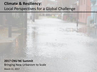
- 1. Climate & Resiliency: Local Perspectives for a Global Challenge 2017 CNU NE Summit Bringing New Urbanism to Scale March 31, 2017
- 2. WHO WE ARE: Jonathan Ford, PE – moderator Horsley Witten Group Senior Project Manager – Community Design Stephanie Zurek, AIA Union Studio Associate Leah Bamberger City of Providence Director of Sustainability Anne Tate, AIA Rhode Island School of Design Professor of Architecture
- 3. ecoRI News & NOAA Technical Report NOS CO-OPS 083, January, 2017
- 4. New York Times, March 21, 2017 & Yale Program on Climate Communication
- 5. New York Times, March 21, 2017 & Yale Program on Climate Communication
- 10. CLIMATE AND RESILIENCY: LOCAL INSIGHTS FOR A GLOBAL CHALLENGE Starting the conversation: a case study from Newport, RI Photo: Caroline Goddard
- 11. CLIMATE AND RESILIENCY: LOCAL INSIGHTS FOR A GLOBAL CHALLENGE Photo: onne van der wal
- 12. CLIMATE AND RESILIENCY: LOCAL INSIGHTS FOR A GLOBAL CHALLENGE Howe, P., Mildenberger, M., Marlon, J., & Leiserowitz, A. (2015) “Geographic variation in opinions on climate change at state and local scales in the USA,” Nature Climate Change. DOI: 10.1038/nclimate2583. http://climatecommunication.yale.edu/visualizations-data/ycom-us-2016/
- 13. CLIMATE AND RESILIENCY: LOCAL INSIGHTS FOR A GLOBAL CHALLENGE • What are current environmental conditions? • What are environmental projections? • Where are the social, economic, environmental and infrastructure vulnerabilities? • What are the options – short-term, medium-term and long-term? • How do we effectively weigh those options? • What resources are available and how should they be allocated? • Who decides? • Changes will affect communities – very personal and emotional decision-making process In communities across the country, we have large, sticky conversations ahead of us:
- 14. CLIMATE AND RESILIENCY: LOCAL INSIGHTS FOR A GLOBAL CHALLENGE 74 Bridge Street Case Study The Point, Newport, RI The Point Downtown Newport
- 15. CLIMATE AND RESILIENCY: LOCAL INSIGHTS FOR A GLOBAL CHALLENGE
- 16. CLIMATE AND RESILIENCY: LOCAL INSIGHTS FOR A GLOBAL CHALLENGE • Current environmental conditions:
- 17. CLIMATE AND RESILIENCY: LOCAL INSIGHTS FOR A GLOBAL CHALLENGE The Point
- 18. CLIMATE AND RESILIENCY: LOCAL INSIGHTS FOR A GLOBAL CHALLENGECLIMATE AND RESILIENCY: LOCAL INSIGHTS FOR A GLOBAL CHALLENGE Affected areas of projected sea level rise: 1’, 3’, 5’ - Newport, RI Rendering: Markley Boyer • Environmental projections: The Point
- 19. CLIMATE AND RESILIENCY: LOCAL INSIGHTS FOR A GLOBAL CHALLENGE
- 20. CLIMATE AND RESILIENCY: LOCAL INSIGHTS FOR A GLOBAL CHALLENGE • Social, economic, environmental and infrastructure vulnerabilities? Social: homes, livelihoods, cultural heritage Environmental: Changes in local species and habitats Economic: Flood insurance, loss of tax base Infrastructure: Stormwater system, Tide gates
- 21. CLIMATE AND RESILIENCY: LOCAL INSIGHTS FOR A GLOBAL CHALLENGE • What are the options? Sea level rise Stormwater Design Guidelines
- 22. CLIMATE AND RESILIENCY: LOCAL INSIGHTS FOR A GLOBAL CHALLENGE • How do we effectively weigh the options?
- 23. CLIMATE AND RESILIENCY: LOCAL INSIGHTS FOR A GLOBAL CHALLENGE City Residents Engineers Historic
- 24. CLIMATE AND RESILIENCY: LOCAL INSIGHTS FOR A GLOBAL CHALLENGE • What resources are available and how should they be allocated?
- 25. CLIMATE AND RESILIENCY: LOCAL INSIGHTS FOR A GLOBAL CHALLENGE • Who decides? Photo: F. Mullin
- 26. CLIMATE AND RESILIENCY: LOCAL INSIGHTS FOR A GLOBAL CHALLENGE Unlike infrastructure and planning efforts that we have seen in the past, this is not a singular policy decision. It must involve everyone – at the national, state and local level; but, most importantly citizens must get on board with: • Understanding climate change basic facts/science • Understanding local implications of climate change (flooding, sea level rise, increased temperatures, etc) • Problem-solving efforts • Empower communities with knowledge and decision-making tools Photo: C. Goddard
- 28. Mayor Jorge O. Elorza Leah Bamberger, Director of Sustainability
- 29. 29
- 31. 84% 1% 5% 1% 6% 1% 2% 1% White White | Two or more races Two or more races Black or African American | American Indian and Alaska Native Black or African American Asian | Two or more races Asian American Indian and Alaska Native | Two or more races ResilientPVD Lab - Race Demographics 31
- 32. ResilientPVD Lab Recommendations • Establish a people of color led community Advisory Committee • Implement a Race and Social Justice screen • Develop an Equitable Engagement Checklist • Fund Community organizations to lead engagement processes
- 33. Meanwhile… 33
- 34. Update sustainability plan with racial equity lens Get community’s recommendations for a process to incorporate racial equity Co-create a community- driven process Build stronger relationships Equity in Sustainability Initiative
- 36. Racial & Environmental Justice Committee Tasks • Identify key concerns, issues and needs of the community • Base-building • Provide recommendatio ns for a long- term process and structure
- 37. Racial and Environmental Justice Committee Members • 10 community members – 2 Southside – 1 West End – 1 North End – Racial justice – Environmental justice – Indigenous – Low-income – Refugee/Immigrant – Education/Youth • 5 municipal representatives – Sustainability – Mayor’s Office / Policy – Community Development – Healthy Communities – Arts, Culture, & Tourism
- 38. Challenges and Lessons Learned • “Change happens at the pace of trust” • “Control is the opposite of trust” • Inside/outside strategy • Stay focused on long-term goals • Value of a third party consultant • Language, cultural, and economic barriers persist 38
- 39. Early Impacts and Results • High interest in this work • New partnerships and connections • Approach grant applications and program and policy development differently 39
- 40. What’s Next? • Continue to build relationships between the City and community • Initiate larger process to amend current sustainability plan to include racial equity lens • Begin implementation of REJC recommendations • Continue to support base-building and community organizing • Transfer lessons learned from this initiative across City departments 40
- 43. Contact Us Jonathan Ford, PE Anne Tate, AIA jford@horsleywitten.com atate@risd.edu Leah Bamberger Stephanie Zurek, AIA lbamberger@providenceri.gov stephanie@unionstudioarch.com
- 45. COURAGEOUS COMMUNITIES Jonathan Ford, PE Horsley Witten Group
- 49. INUNDATION HT + 2’ SLR + 100-Year Event SVR Design Bath, Maine AIA DART
- 50. SVR Design Bath, Maine AIA DART FRAMEWORK
- 51. RESILIENCY GreenBath • Build Greenways: Work with water – weave green/blue fingers into downtown • Allow migration: Plan new wetland migration zones for SLR, shoreline retreat • Treat runoff: Green Infrastructure to naturally filter runoff •Harden edge: Elevate buildings & armor edge for storm surge ge: Kevin Robert Perry
- 52. SVR DesignMike Davis, FAIA, Bergmeyer
- 53. Mike Davis, FAIA, Bergmeyer
- 54. Mike Davis, FAIA, Bergmeyer
Notas do Editor
- Climate change as a challenge to coastal communities in New England that have cultural, economic and historic ties to the water
- But, when only 40% of americans believe that climate change will affect them personally, how do we move the conversation now? Let alone issue of adaptation…
- Studied specific house in context of broader point neighborhood – one of most historic and unique sections of Newport
- Not just singular events; residents Experience regular flooding that affects homes and disrupts daily life Combination of stormwater drainage butting heads with tidal water in the drainage infrastructure system
- Involves looking backwards, as well as forward
- This map shows the effects of 1’, 3’ and 5’ SLR. Although, climate scientists have now revised estimates for RI to 9’-10” by 2100. Predictions for future: RI – NOAA revised estimate 9’-10” SLR by 2100
- Putting all ideas out on the table, identifying priorities for decision-making and taking action
- Investing in long-term solutions vs short-term solutions?
- Because adaptation involves so many parties; it is about putting all information out there in the most concise and clear way to allow residents and policy-makers to decide together
- It is our job to be facilitators
- Brookings said it focused on the difference between households at the top – those earning more than 95 percent of all other households – and those closer to the bottom – those earning more than 20 percent of all other households – for each of the 100 largest U.S. metro areas and the largest city in each of those metro areas, based on 2014 data. Providence showed a large difference in household incomes - $196,691 at the 95th percentile and $12,795 at the 20th percentile, creating a 95/20 ratio of 15.4 percent. In comparison, Boston’s ratio was 17.8 percent, based on high earners at $266,224 and low earners at $14,942.
- Community-centered planning is essential to achieving equitable climate preparedness outcomes. Create a Community-Defined vision of resilience. Develop Neighborhood-Specific climate vulnerability assessments and resilience plans, include metrics. • Work at the Nexus of Climate Preparedness & Neighborhood Needs. • Increase Individual and Community disaster preparedness. Culturally appropriate emergency preparedness outreach. Neighborhood emergency hubs. Empowered and Connected Neighbors are More Resilient
- Enhance the relationship between the City of Providence and the neighborhoods that it works to serve Create a model and mechanism for developing a sustainable city with community-based decision-making that influences city governance. Make recommendations for short and long-term actions to better incorporate social and racial equity in the City’s sustainability planning efforts.
- Committee member roles Provide recommendations for integrating concerns of people of color into City sustainability planning. Attend four committee meetings between November 2016 and June 2017. Participate in a two-day racial equity training led by internationally-known trainers from thePeople’s Institute for Survival and Beyond. Create and execute a work plan for engaging five to ten community members throughout the seven-month process to drive participation and collect feedback from your community base. Report feedback from your community members to the REJ Committee during REJ meetings. Help design and attend a final public meeting, present recommendations, and discuss next steps
- Committee member roles Provide recommendations for integrating concerns of people of color into City sustainability planning. Attend four committee meetings between November 2016 and June 2017. Participate in a two-day racial equity training led by internationally-known trainers from thePeople’s Institute for Survival and Beyond. Create and execute a work plan for engaging five to ten community members throughout the seven-month process to drive participation and collect feedback from your community base. Report feedback from your community members to the REJ Committee during REJ meetings. Help design and attend a final public meeting, present recommendations, and discuss next steps
- -The Process is slow - All project partners are taking a risk by giving up some control of their work - Press release example -Inside/outside strategy – community and government need to tackle this work simultaneously but independently, yet in close coordination - challenge of translating this work to colleagues -some organizations can’t get involved because of other hot-button issues w/ the City. That’s okay. Need to start with bridge builders—people who are willing and able to take a step back and take a long-view. Community needs both. -Addressing conflicting community perspectives: the community doesn’t have one voice -folks refusing translation / not being comfortable speaking about personal concerns in public / participation challenges
- Interest in the work from peers in government, other community organizations (YIA), and funders (Island Foundation, year 2) -Many colleagues are eager and excited to have these conversations internally. And I am now seen as a resource to other departments to improve community relations and get more diverse participation and engagement. This is a great entry way for some departments to begin this work. Who shows up is highly visible, and people are highly critical of this. The pursuit of a diverse turnout at a community meeting makes some people willing to try a different approach and is a great gateway into the subject -turnout at REJC base building meeting – RI GIC connection Approach to work Ensure funding for community participation Develop proposals with community partners and get early buy-in
- Continue to build relationships between the City and community Create an Equity in Sustainability implementation plan to based on REJC recommendations Begin implementation of at least one recommendation from the REJC that is identified as critical for laying the groundwork for long-term success and institutional change Support base-building and community organizing to ensure the long-term success of this work. Transfer lessons learned from this initiative across City departments
- A resilient Bath will integrate these four planning and design strategies into downtown’s future vision. The inundation mapping clearly demonstrates a need to redefine and harden the waterfront edge east of Front Street to combat SLR. Retreating the shoreline west over time will help redirect growth to higher ground while also allowing for establishment of new wetland migration zones. The community is intensely aware of and connected to the water, so a public spirit of celebration of water can extend into the downtown with the establishment of “green/blue fingers”. Elm Street and Water Street, for example, could be redesigned to include natural wetland systems and safely and strategically allow temporary storm surge into the downtown. This could be a cost effective way to handle storm inundation – working with the water – and also enhance economic value as a cultural and aesthetically pleasing downtown visual element.
- Sea level rise is only one impact of climate change to be considered when planning the direction of Bath’s downtown. According to the Intergovernmental Panel on Climate Change (IPCC), precipitation intensity and variability have increased over most land areas. In Bath, MHHW plus 2 feet of sea level rise, possible within the next 40 years, combined with storm surge impact from a 100-Year storm event, expands the impact west across Commercial Street and down Elm/Water Street. It is interesting to note that the configuration of downtown Bath is not a coincidence when viewed through this lens, as the heart of downtown is located on an island of high ground. Front Street used to be the waterfront street, and the waterfront was expanded east over time including the addition of Commercial Street. Current Water Street and the railroad corridor both are historic streams.
- Bath’s downtown framework concept centers on Front Street and Washington Street as existing north-south spines, with desire to extend the Front Street downtown experience north of Elm Street towards the Hampton Inn. Opportunities include reimagining of existing connections between Front Street and Commercial Street as “ways to the water” prioritizing pedestrian connectivity, waterfront open space, and viewsheds. Vine Street is often perceived as a neglected fragment of the downtown fabric. Enhancement of gateway nodes at the intersections of Front/Vine and Washington/Vine would be high-value improvements.
- A resilient Bath will integrate these four planning and design strategies into downtown’s future vision. The inundation mapping clearly demonstrates a need to redefine and harden the waterfront edge east of Front Street to combat SLR. Retreating the shoreline west over time will help redirect growth to higher ground while also allowing for establishment of new wetland migration zones. The community is intensely aware of and connected to the water, so a public spirit of celebration of water can extend into the downtown with the establishment of “green/blue fingers”. Elm Street and Water Street, for example, could be redesigned to include natural wetland systems and safely and strategically allow temporary storm surge into the downtown. This could be a cost effective way to handle storm inundation – working with the water – and also enhance economic value as a cultural and aesthetically pleasing downtown visual element. 1. LOVABLE 2. PILOT Green infrastructure helps to mimic nature by naturally filtering and infiltrating stormwater as close to where it falls as possible. Infiltration may be limited given the high groundwater and ledge conditions in downtown Bath, but green infrastructure still provides water quality filtration benefit and helps to slow and soak in stormwater runoff.
- The long-term vision for downtown includes a network of green streets and green/blue fingers. The primary green/blue finger is Elm Street and Water Street, which could be rebuilt to work with the water including created wetland systems and safe accommodation of temporary inundation during storm events. Relatively steep east-west streets connecting Front Street and Commercial Street should be improved to prioritize pedestrian traffic and include green infrastructure to slow and filter stormwater runoff before discharge to the river. Parking lots can also be green, including bioretention systems and permeable pavement.
- The long-term vision for downtown includes a network of green streets and green/blue fingers. The primary green/blue finger is Elm Street and Water Street, which could be rebuilt to work with the water including created wetland systems and safe accommodation of temporary inundation during storm events. Relatively steep east-west streets connecting Front Street and Commercial Street should be improved to prioritize pedestrian traffic and include green infrastructure to slow and filter stormwater runoff before discharge to the river. Parking lots can also be green, including bioretention systems and permeable pavement.
- The long-term vision for downtown includes a network of green streets and green/blue fingers. The primary green/blue finger is Elm Street and Water Street, which could be rebuilt to work with the water including created wetland systems and safe accommodation of temporary inundation during storm events. Relatively steep east-west streets connecting Front Street and Commercial Street should be improved to prioritize pedestrian traffic and include green infrastructure to slow and filter stormwater runoff before discharge to the river. Parking lots can also be green, including bioretention systems and permeable pavement.