SlideShare uma empresa Scribd logo
1 de 59
Baixar para ler offline
B    U N D O R A N    F A R M
    A Conservation Community
PREPARED BY


AN AFFILIATE OF


       2
CONTENTS
INTRODUCTION                                04


THE VISION                                  05


THE PROPERTY                                06


THE REGION                                  08


THE HISTORY                                 10


SITE INVENTORY & ANALYSIS                   13
     PROCESS
     EXISTING ROADWAYS
     PUBLIC VIEWSHED
     STREAM CORRIDORS & WETLANDS
     PRODUCTIVE FARMLAND
     FOREST/WILDLIFE HABITAT
     MOUNTAIN PROTECTION ZONES
     PRESERVATION AREAS
     POTENTIAL DEVELOPABLE AREAS
     HOMESITES
     SLOPE
     ASPECT


SITE DESIGN ELEMENTS                        29
     EASEMENTS
     PROPOSED ROADWAYS
     PHASING
     MASTER PLAN
     SUSTAINABILITY CENTER PROCESS
     SUSTAINABILITY CENTER DESIGN
     HOMESITE DEVELOPMENT
     PRIVATE RESIDENCE
     AUDUBON


SUMMARY                                     47


APPENDIX                                    49


3
BUNDORAN FARM


INTRODUCTION
In Southern Albemarle, on the upper
branches of the Hardware River, lies
Bundoran Farm. Home to a family
of farmers since 1940, this valley is a
place where the traditions of peaceful,
sustainable country life have never gone
away. The landscape is as varied as it is
spectacular. The vast areas of verdant
pasture, orchard, and well-managed
forest are interspersed with riding and
walking trails; and the breathtaking
views of the farm, the valleys, and
the Ragged Mountains in the distance
cultivate a sense of a place that is
enduring, timeless, and deeply rooted in
tradition.

Bundoran farm is comprised of 2,300
acres of rolling Albemarle County
countryside located twenty minutes
from Charlottesville and the renowned
University of Virginia. The mindful
stewardship of this land over the years
has resulted in a place that would
not be unfamiliar to a visitor from
the time of Thomas Jefferson. Heavy
stands of orchard grass and fescue
cover a landscape of rolling pastures
and secluded valleys and hollows. A
fifteen-mile network of riding trails,
sprinkled with benches and gazebos,
leads visitors through a dazzling variety
of mature Piedmont forest species,
through and along the streams that
tumble down through each valley.
Two ponds provide a place for quiet
reflection or fishing; and farm buildings
and cottages dot the landscape, framing
views that typify the slower pace and
natural beauty of the Albemarle County
lifestyle.

Bundoran Farm is also the location of a
new kind of rural community; one that
presents a unique concept of farmland
and forest preservation, combined
with extremely limited residential
development. In the case of Bundoran
Farm, these principles result in a low-
density community of approximately
one hundred homesites, with the great
majority of the farm’s acreage put under
a unique regime of easements and deed
restrictions to ensure the character,
function, and maintenance of the farm
in perpetuity.


                                            4
THE VISION
Analogous to the principles of             At the heart of the vision for Bundoran
sustainability and the “triple bottom      Farm is the idea of the “Working
line,” the fundamental model of            Landscape”. It is one of the key
Preservation Development has been          elements that distinguishes Preservation
described as a “three-legged stool.”       Development from other real estate
Each leg of this stool represents a        developments, even those that place
different activity and a different         lands in conservation or preservation
constituency, and all three bear an        covenants. Bundoran Farm is a working
equal amount of weight. At Bundoran        industry whose base of operations is
Farm the three legs of the stool are:      the topsoil. This is true of all farms (and
                                           when we speak of farms here, we speak
1. Farming – represented by                broadly, including all properties that
   agricultural work and land              make productive use of the land for
   management activities;                  pasturelands, woodlots, orchards, etc.).
2. Environmental Goals – expressed         Unique to Preservation Development
   at Bundoran Farm by the work of         is the fact that we are retaining that
   Audubon International; and              working arrangement, so any successful
3. Home Development – exhibited            approaches to developing the land must
   by home ownership and residency         be consonant with this situation. This is
   on a working farm.                      not an approximation of living on a golf
                                           course or beside a national park. The
Taken together, these three                land has been and will continue to be
interdependent legs of the stool           manipulated, worked, and managed. As
create a seat or platform that is          such, it is not “natural” in the romantic
both enduring, meaning capable             sense of the word, which is to say it is
of sustaining itself into future           not pristine. These lands are and will
generations, and replicable, serving as    remain, however, earthy, beautiful,
a model for similar developments that      meaningful, and deeply rooted not only
share this approach.                       in nature but also in millennia of human
                                           activity.
Historically, the settlement of
rural areas was accomplished by
cataloging valuable resources such
as water, soils, crops, and trees and
then building where the land was
least productive. The creation of the
Bundoran Farm community followed
a similar pattern. The result is not
reflective of a particular idealogy, such
as “New Urbanism,” “New Ruralism,”
or “Conservation Development.”
Rather, the design has been a process
of rigorous analysis and a great deal
of time spent in the field.

To start, the project team designated
areas for permanent protection and
enhancement and worked backward
to locate homesites that leave
intact the most precious and fragile
resources of the land.


     5
BUNDORAN FARM


THE PROPERTY
Bundoran Farm rests in the serene
countryside of Central Virginia that
Thomas Jefferson once described as “the
Eden of the United States”.

The 2,300 acres of Bundoran Farm
comprise an extraordinary parcel of
farmland, forest, orchards, cottages, and
estates in southern Albemarle County.
Straddling Plank Road (SR 692) west
of US 29 South, as well as Edge Valley
Road (SR 696) north of Plank Road, this
scenic property is familiar to commuters
and cyclists and to the Albemarle
agricultural community as the previous
home of the Albemarle County Fair.

The farm’s landscape is varied, but in
many ways typical of rural Albemarle.
1,000 acres, or roughly half of the
farm, is wooded and a good example
of well-managed mature Piedmont
hardwood forests. Orchards bearing
red and golden delicious apples
cover approximately 200 acres. The
remainder, roughly 1,100 acres, is
fenced, well-watered pastures of
orchard grass and fescue, and includes
a cow-calf operation. The farm is
also home to two estates; nine rental
cottages; and numerous agricultural
shops, barns, and other outbuildings.

The property, assembled by continuous
acquisitions of parcels over the past
sixty years, has for decades embodied
the value of stewardship of forest land.
Very limited harvesting, as well as
localized timber stand improvement
and, more recently, aggressive invasive
eradication work in conjunction with the
Virginia Department of Forestry have
resulted in large areas of exemplary
mature forest. Likewise, the careful
management of the farm over many
years has resulted in pastures and
orchards relatively free of many of the
invasive-species challenges typical
of nearby parcels. Management of
cattle operations has been generally
good, but uneven, across the various
pasture areas. Over the past few years,
pastures have been under several leases,
with varying levels of commitment
to rotational grazing and other best
management practices.

Baseline water testing for sedimentation
and for marker species (“bug counts”),
bears out this initial assessment,
showing markedly reduced impacts
in areas with faster rotation schedules.


                                            6
The farm has, over the past decade
    or so, moved in this direction and is
    expanding the lease area of the operator
    with the most fervent commitment to
    these principles.

    The farm abuts the southern edge of the
    Rivanna watershed, but the property
    itself drains to the Hardware River. In
    fact, one primary perennial stream is the
    Middle Branch of the North Fork of the
    Hardware River. In accordance with
    county and state policies, a wetlands
    delineation was performed on the
    property and submitted with the Final
    Plat Application.

    Two constructed ponds can also be
    found on the property. In one case,
    Lake Scogo, the dammed stream has
    sponsored a limited, though functional
    vegetated wetland. Intervention in
    this area will be include a long-term
    program of assessment and invasive-
    reduction.

    The thousand or so acres of hardwood
    forest include valuable habitat, as do the
    large grassland areas of the pastures.
    Initial assessment tells us that the
    primary habitat of value, in a regional
    perspective, is the large unfragmented
    areas of interior forest. Of special
    value are those on the west side of the
    property, which abut large contiguous
    acreage used for timber. However,this
    habitat faces issues typical of large
    forested parcels in the area, particularly
    those concerning deer population
    control.

    The property hosts an active hunt
    club, implementing a state-directed
    deer management assistance
    program (DMAP), a site-specific deer
    management program that increases a
    landowner’s or hunt club’s management
    options for control of deer populations.
    The team is committed to continuing the
    DMAP program in perpetuity. Other
    communities in the area that have not
    responded to this challenge at the time
    of development are often forced to do
    so later, with concurrent disruption and
    expense.


7
BUNDORAN FARM


THE REGION
Albemarle County is located in Central      Perhaps the most noted characteristic
Virginia and within the Piedmont            of the region is its exceptional natural                                                                                                                                           29

Plateau. Boasting a rich history,           beauty and magnificent surroundings.
Albemarle County is known worldwide         Situated in the foothills of the stunning
as the home of Thomas Jefferson’s
                                                                                                             240
                                            Blue Ridge Mountains, the area draws                    CROZET


Monticello, James Monroe’s Ash Lawn-        on the best traditions of Virginia country                                250
                                                                                                                                                                    IVY
                                                                                                                                                                                                        250

Highland, and Patrick Henry’s Red           living and its distinctive and individual                                                                                                                         29
Hill and is within close proximity to       lifestyle. Located just minutes from                                                                              64                                        UVA
                                                                                                                                                                                                                                    250

some of the most notorious battle sites     historic Charlottesville, Bundoran’s                                                       DS
                                                                                                                                            ROAD
                                                                                                                                                                                                                            DOWNTOWN


of the Civil War, including Richmond,       residents will be part of this progressive,
                                                                                                                                  OO
                                                                                                                              W                                                                           CHARLOTTESVILLE
                                                                                                                          K                                                                                                               64
                                                                                                                       DIC


Wilderness, and Appomattox.                 vibrant community which offers fine
                                            art museums, an array of performing


                                                                                                                                                          .
                                                                                                                                                        RD
                                                                                            BATESVILLE
Albemarle County enjoys a modified           arts venues, annual equestrian events,


                                                                                                                                                          P
                                                                                                                                                       GA
                                                                                                                                                    RS
continental climate with mild winters


                                                                                                                                                  LO
                                            and the nationally recognized Virginia


                                                                                                                                              TAY
                                                                                                                            VALL
                                                                                                                GE              EY                                 29
                                                                                                              ED


and mild to humid summers. The              Film Festival. In addition, residents and                                                                                                         AD
                                                                                                                                                                                            RO

average temperature from June to            their guests will enjoy experiencing the
                                                                                                             PL


                                                                                                                                                                                        G
                                                                                                               AN


                                                                                                                                                                                      UR
                                                                                                                 K
                                                                                                                     RD


                                                                                                                                                                                    HB
                                                                                                                       .      NORTH GARDEN


                                                                                                                                                                                  NC
August is 75 degrees and the average        area’s many award-winning vineyards,


                                                                                                                                                                               LY
                                                                                                                                                                          OL
                                                                                                                                                                            D                      20
                                                                                                                                            712
for December through February is 37         fine antique shops, and the University of
degrees. Average annual rainfall is         Virginia’s Academical Village.
47.29 inches and snowfall is 24.2 inches.

Albemarle County was formed in 1744
from Goochland County and named
for William Anne Keppel, the second
Earl of Albemarle, titular governor of
Virginia from 1737 to 1754. In 1761
the county government was moved to
Charlottesville, which was established
as a town in 1762. Albemarle County
is approximately 110 miles southwest
of Washington, D.C., 70 miles west of                                                     ALBEMARLE COUNTY, VIRGINIA
                                                                                          Located in the Piedmont region of Central Virginia
Richmond, and 115 miles northeast of
Roanoke. The county surrounds the
city of Charlottesville and shares the
University of Virginia campus.

The majority of the county’s 721 square
miles are designated for rural area
protections, with just over 72 square-
miles, or roughly 10 percent, set aside
for urban-residential, commercial, and
industrial land uses. As of 2007, 895
farms were operating in the County,
accounting for 158,317 acres, or a little
over 34 percent of the County’s total
land area. Farming practices are diverse
and include cattle, equestrian, and even
buffalo operations as well as a number
of orchards and a rapidly growing
number of vineyards.


                                                                                          BUNDORAN FARM
                                                                                          SE portion of Albemarle County,
                                                                                          Piedmont Upland Physiographic Region


                                                                                8
tai ian
  un ch
       ns
Mo pala
 Ap


                  JAMES RIVER


              Charlottesville


                   NORTH


 9
BUNDORAN FARM


THE HISTORY
The rolling hills and valleys of
Bundoran Farm are the product of
billions of years of natural history and
thousands of years of human use. It has
known landlocked mountains reaching
higher than the Himalayas; it has been
a coastline, a seabed, and a featureless
plain. The land has been nourished
with minerals washed from rivers
and mulched with the rich compost
of innumerable species of plants. The
area’s rivers have revealed its valleys as
mountains have slowly risen again, and
may still be rising.

Even before Europeans arrived, the
land around Bundoran might have
been cleared and cultivated. Within a
virgin forest of magnificent American
Chestnut, whose trees towered as
much as 160 feet above the ground,
the ancestors of the Monacan Indian
Nation may have maintained fields near
villages here.

Although we have no certain proof,
the rich soils still present today suggest
that natives might have settled and
cultivated fields in the bottom lands of
Bundoran. They would have burned
such fields annually in order to keep
them open, either for agriculture or to
attract wildlife. And these first peoples
likely would have cultivated tobacco
here, which was sacred to them, and
probably taught visitors how to do the
same.

Bundoran’s topsoil has been in nearly
constant production since that time,
including tobacco which was a popular
crop even among the earliest settlers.
Unfortunately, these pioneer farmers
did not necessarily understand the
benefits of growing their crops in line
with the land’s contours. Moreover,
tobacco does not grow well in soggy
soil, so it appears that early tobacco
farmers dug deep ditches down the
hillsides, perpendicular to the contours,
to drain water from the rolling fields.
Such practices put the topsoil at risk.
And this, combined with the heavy toll
tobacco takes on the soil’s nutrients,
meant that farmers had to turn to other
other crops that were better suited to the
conditions, such as corn and fruit.

Luckily the hills around Bundoran are
ideal for growing apples. Each spring,
the cool air sinks along the slope of


                                             10
the hillsides and drains away from
     the new apple buds, preventing them
     from freezing. The lower grounds have
     always provided perfect pasturelands
     for livestock.

     The land itself was discovered by
     settlers in the early 18th century when
     scouts following the North Fork of the
     Hardware River determined that the
     area we know as Bundoran Farm was
     a prime site for settlement and called
     it North Garden. Other westward
     explorers following the South Fork of
     the Hardware River named that region
     South Garden. North Garden and
     South Garden can be geographically
     described as two natural “bowls” with
     higher ground between them. The fertile
     bottomland soils surrounding mountain
     forests and the adjacent Hardware
     River provided the basic needs for early
     settlers and opportunities to trade and
     prosper.

     After the Revolutionary War, more
     and more settlers crossed the Blue
     Ridge Mountains of Virginia to
     live in the Shenandoah Valley and
     Trans-Allegheny region. A way of
     transportation connecting the east and
     west was needed to accommodate
     the increasing population, and so the
     Staunton or Rockfish Gap Turnpike
     was authorized in 1818. Bisecting the
     southwest quarter of the county, the
     turnpike linked the port of Scottsville
     on the James River directly with the
     Shenandoah Valley and its many
     agricultural products. The high ground
     between North and South Garden
     emerged as a regional hub when
     the new Staunton or Rockfish Gap
     Turnpike created an intersection with
     Old Lynchburg Road. Locals called it
     the Crossroads. In 1818, the Sutherland
     family built the Crossroads Tavern on
     the corner of Rt. 29 and Plank Road (SR
     692) for travelers and farmers using the
     Staunton and James River Turnpike.

     The farm as we know it today was
     originally purchased by the Scott
     family in the 1940s, was assembled by
     continuous acquisitions of parcels over
     the past sixty years, and has for decades
     been a testament to the value of land
     stewardship.


11
BUNDORAN FARM


                12
SITE INVENTORY & ANALYSIS
A number of inventory and          Field visits and on-site reconnaissance
analysis studies were conducted    were necessary to investigate design
pertaining to the physical         opportunities and constraints and to
elements of the farm property.     familiarize the team with the property.
These studies, and the resulting   Assessment of natural and man-made
findings, assisted the team in      factors and land uses were all part of
making solid, justified, and        the site investigation. The following
appropriate planning and design    analysis describes the implications and
decisions for the project.         characteristic of each physical element.


PROCESS                                                                  14


EXISTING ROADWAYS                                                        16


PUBLIC VIEWSHED                                                          17


STREAM CORRIDORS AND WETLANDS                                            18


PRODUCTIVE FARMLAND                                                      19


FOREST/WILDLIFE HABITAT                                                  20


MOUNTAIN PROTECTION ZONES                                                21


PRESERVATION AREAS                                                       22


POTENTIAL DEVELOPABLE AREAS                                              23


HOMESITES                                                                24


SLOPE                                                                    25


ASPECT                                                                   26


13
BUNDORAN FARM


PROCESS
“A SUBTRACTIVE PROCESS”                     On top of these, the design team then
                                            mapped critical natural resources of all
The design of the Bundoran Farm             kinds, including forest and meadow
community has embodied the notion           habitats; water resources such as
of a bottom-up approach. The                streams, wetlands, and ponds; and
design team came to the land with           many individual areas particularly
a great deal of combined experience         threatened by development or farming
in land-planning, conservation, and         activity, such as steep slopes, micro-
community development, but with no          habitats, and wildlife corridors. This
preconceptions.                             analysis extended to improvements and
                                            common area amenities such as trails,
The design process at Bundoran              recreation areas, and scenic views.
Farm began with the land itself. An
exhaustive, iterative process, involving    Finally, the selection of homesite
numerous professionals from the fields       locations and the design of the final
of landscape architecture, engineering,     homesite is the result of the culmination
farming, forestry, and real estate          of this rigorous anaylsis and assessment
development was applied. In the case        process, coupled with considerable time
of the 2,300 acres comprising Bundoran      spent on the ground.
Farm, this process took the team
over a year to complete and reflects a
philosophy to “let the land tell you what
to do.”

First, the areas of the farm under
cultivation or pasture were cataloged
and evaluated, with the goal of
identifying the most productive,
economically viable, and sustainable
agricultural land. The key here was
to protect large, contiguous, accessible
areas with good soils, shade, and
water. At Bundoran Farm, this analysis
extended to the identification and
protection of important stands of timber
and forest environments.

Next, the design team overlaid a
“viewshed” analysis, documenting
areas of the farm that are visible from
public and private roads, homesites,
and adjacent properties during different
seasons in order to determine areas
that should be preserved to maintain
the scenic and rural character of the
property.


                                                                               14
15
BUNDORAN FARM


EXISTING ROADWAYS
LAY LIGHTLY ON THE LAND

The existing roads, paths, and trails
were located, studied, and whenever
possible, incorporated into the
engineered road system of the Farm.
The end results are roads that “lay
lightly on the land” as well as minimal
soil disturbance.

EXISTING ROADS

-State Roads (Plank, Edge Valley)
-Existing Paved/Treated Roads
-Existing Farm Roads (dirt/gravel)


                                                EXISTING STATE ROADS


                          EXISTING FARM ROADS


                        EXISTING PAVED ROADS


                                                Red - Existing Roadways


                                                                          16
PUBLIC VIEWSHED
                                        PROTECTION OF THE PUBLIC
                                        VIEWSHED

                                        The land of Bundoran Farm is an
                                        iconic image of Albemarle County. A
                                        top priority was to protect the visual
                                        character of this landscape. A series
                                        of studies were undertaken to fully
                                        understand what people see and
                                        experience as they travel along the
                                        public roads and through the pastures
                                        and meadows of the farm


PUBLIC VIEWSHED


   Yellow – Areas Visible From
   Public Roads During
   Non-Winter Months.


                                 17
BUNDORAN FARM


STREAM CORRIDORS & WETLANDS
The streams, ponds, and wetlands
found at Bundoran Farm are valued,
sensitive resources. In addition to
providing water for agricultural and
recreational activities, the water courses
lead to the Hardware River, the James
River, and eventually to the Chesapeake
Bay. Ongoing water quality testing is
underway to fully assess the impacts of
the development and natural resource
management concepts.

PROTECTION OF STREAM CORRIDORS
& WETLANDS

-Two major constructed ponds
-Stream corridors delineate perennial /
 intermittent watercourses
-Preserves on and off site water quality
-Creates abundant wildlife habitat


                                             CONSTRUCTED POND


                                                    STREAM CORRIDOR


                                CONSTRUCTED POND


                                                 Light Blue - Stream Corridors &
                                                 Wetlands


                                                                          18
PRODUCTIVE FARMLAND
                                                  PROTECTING THE FARM

                                                  A major focus of the design process was
                                                  protecting and preserving the Bundoran
                                                  landscape. This was accomplished in
                                                  part by placing all areas of the farm that
                                                  are actively managed for agriculture
                                                  practices under agriculture easement.

                                                  Under guidance from a steering
                                                  committee and an on-site Natural
                                                  Resources Manager, the resident
                                                  farmer is allowed use of this land for
                                                  cattle, orchards, or other farm use,
                                                  employing practices approved Audubon
                                                  International for Bundoran Farm.
                                                  Most forested areas of the property are
                                                  under conservation easement, which
                                                  commits the managers to maintain the
                                                  forest under a professionally-developed
                                                  plan for timber stand and wildlife
                                                  preservation.

                                                  Individual homesites are located in
                                                  the seams between these important
                                                  agricultural and forest areas, typically
PASTURE/CATTLE                                    in locations with good access and
                                                  incomparable views. In the end,
                                                  with many individuals owning a
                                                  piece of the property, the farm still
      ORCHARD                                     provides large contiguous areas for
                                                  pasture, recreation, and forestry which
                                                  guarantee the future viability of all these
                                                  functions. Furthermore, road access is
                                                  not designed to minimize expense, an
                                                  approach that typically results in short
                                                  culs-de-sac and homes located close to
                                                  public roads. Rather, Bundoran Farm
                                                  accepts unusually long roads, when
                                                  required, to minimize fragmentation
                                                  or other disturbance of agricultural or
                                                  forestal uses.

                                                  In return for allowing easements on
                                                  their property, homeowners receive
                                                  two benefits. First, though they may
                                                  have bought only a few acres, they are
                                                  welcome to use the entire farm property.
                                                  Second, the maintenance of this land as
                                                  farmland protects the investment of the
                                                  homeowner, as there is no possibility
                                                  of a neighbor changing the character of
                                                  adjacent property to non-agricultural
                                                  use.

                                                  Large, contiguous areas of productive
                                                  farmland are essential to maintaining
                                                  the local economy, culture and
  Light Yellow – Pasture / Cattle                 landscape. Bundoran Farm’s pastures
  Operations                                      and orchards not only help to enable
  Orange – Under Orchard Leases                   more efficient agricultural operations,
  Essential to maintenance of local               they also protect the primary public
  economy, culture and landscape.                 viewsheds.
  Principal public viewsheds.


                                      19
BUNDORAN FARM


FOREST/WILDLIFE HABITAT
FOREST STEWARDSHIP

Recognizing that this land is part of the
larger ecosystem of the area’s Piedmont
forests, Bundoran Farm will continue in
its commitment to sustainable, long-
term thinking in forestry management.
While management plans that have been
in place for decades will continue to be
followed and updated, the Bundoran
project has partnered with Audubon
International to create a comprehensive
plan for the property with the goal         FOREST/WILDLIFE HABITAT
of maintaining and improving the
important functions of this land in the
areas of water quality and wildlife
habitat. Large portions of forested land
on the site will remain as preserves for
wildlife; and the streams, ponds, and
wetlands will be monitored, maintained,
and protected for future generations.

A significant component of the land and
natural resource management includes
native wildlife habitat protection
and enhancement. Large contiguous
areas of Piedmont hardwoods have
been mapped and will continue to
benefit from a comprehensive forest
management plan. These vast acreages
provide a wonderful and diverse
habitat for plants, animals, and human
recreation.

PLANT & ANIMAL HABITAT

Although a number of struggling native
species such as the white-tailed deer
have recovered, losses of other native
plants and animals are a significant
concern. For example, a number of
eastern migratory songbirds are in
decline, likely due to human activities.
Those declines are caused by several
factors such as fragmentation of
habitat-- the dividing of large areas
into smaller parcels, and the resulting
disruption of forest cover.

As stated in the Albemarle County
Comprehensive Plan: “Wildlife
is a renewable natural resource
which requires both protection and
harvesting for proper management.
The mountainous areas of the County
contain the more dense populations of
wildlife...” By planning for the active
management and protection of wildlife
habitat, the design team sought to            Green - Forest/Wildlife Habitat
position Bundoran Farm as a model of
this philosophy.

PRESERVE FOREST/WLIDLIFE HABITAT

Because of its high value for wildlife
habitat the main focus was on the
preservation of:
Large Contiguous Interior Forest
Areas Adjacent to Neighboring Forests
Areas more threatened than edge
habitat.


                                                                       20
MOUNTAIN PROTECTION ZONES
                                               PROTECTION OF MOUNTAIN
                                               LANDSCAPES

                                               Albemarle County’s mountains have
     MOUNTAIN PROTECTION ZONE                  been and continue to be a source of
                                               income, natural resources, scenic
                                               beauty, and recreation. Directly and
                                               indirectly, the County’s mountainous
                                               areas provide tens of millions of dollars
                                               to the local community in employment,
                                               tourism, and agricultural and forest
                                               products. Beyond the economic benefits,
                                               the mountains provide important
                                               natural functions, such as provision of
                                               clean water, contributions to healthy
                                               air, and habitat for many plant and
                                               animal species. To many residents, the
                                               “blue” backdrop of the mountains gives
                                               Albemarle County its sense of place,
                                               a quality that makes this area special
                                               and consistently ranked among the top
                                               places to live in the United States.

                                               Concerns regarding disturbance of steep
                                               land become pronounced in mountain
                                               areas due to generally shallow soils
                                               and length of grade on side slopes. Soil
                                               erosion, surface water runoff, and septic
                                               system contamination are amplified in
                                               these areas. Forest cover is the optimum
                                               land use for minimizing soil erosion
                                               and maximizing water quality. Soils on
                                               steep slopes are typically more erodible
                                               than in other areas. Inaccessibility and
                                               isolated location of development sites
                                               in mountain areas necessitate longer
                                               driveways and access roads disturb
                                               many times more land area than a
                                               dwelling itself.

                                               Because of their high ecological and
                                               cultural value as well as their propensity
                                               for soil erosion, the mountainous areas
                                               at Bundoran Farm were removed
                                               from the area being considered for the
                                               development of homesites.


Blue – Mountain Protection Zone


                                    21
BUNDORAN FARM


PRESERVATION AREAS
COMBINE PRESERVATION AREAS

By overlaying the previously outlined
elements we were able to determine
the areas suitable for development and
those that should be preserved. This
subtractive approach allowed for the
further refinement of the initial analysis
of the property and provided the
outlines used for the determination of
the developable areas.

Using this subtractive approach versus
the standard by-right development, we       Pasture/Cattle Operations
were allowing the existing landscape to
dictate the location of the developable
areas. By mapping the areas containing
critical natural resources of all kinds,
the team was able to determine those
areas of the landscape with the highest
                                            FOREST/WILDLIFE
cultural and ecological value and those
that were suitable for further analysis     HABITAT
and refinement for the creation of
homesites.                                  EXISTING ROADWAY


                                            STREAM CORRIDORS
                                            & WETLANDS


                                            UNDER ORCHARD LEASE


                                            MOUNTAIN
                                            PROTECTION
                                            ZONE


                                            PUBLIC
                                            VIEWSHED


                                                   Red - Existing Roadways

                                                   Yellow – Areas Visible from Public Roads during non-winter months

                                                   Light Blue - Stream Corridors & Wetlands

                                                   Light Yellow – Pasture/Cattle Operations

                                                   Orange – Under Orchard Leases Principal public viewsheds

                                                   Green - Forest/Wildlife Habitat

                                                   Blue – Mountain Protection Zone


                                                                             22
POTENTIAL DEVELOPABLE AREAS
                                               HOMESITE SELECTION & REFINEMENT

                                               After the project team identified and
                                               overlaid all of these resources on a
                                               map, what was left was the area to be
                                               considered for development. A pattern
                                               of “seams” began to appear, between
                                               forest and field, between wetland and
                                               upland. Within this initial “developable
                                               area,” homesites were defined,
        REMAINING AREAS                        paying close attention to the location
                                               to minimize intrusion on the natural
                                               landscape.

                                               As these site selections were continually
                                               refined over many months both in
                                               the office and in the field, functional
                                               elements like roads, driveways, and
                                               septic systems were considered. Lot
                                               lines were drawn after the fact to
                                               accommodate zoning and to delineate
                                               areas of oversight and easement for each
                                               homesite. The result is a selection of
                                               homesites, at a very low overall density,
                                               each of which share common recreation
                                               areas, viewsheds, and resources in a
                                               way that makes each homesite part of a
                                               larger whole. Each lot is also connected
                                               to many miles of trail and common
                                               resources which, in a more typical
                                               development, would require ownership
                                               of a much larger parcel.

                                               HOMESITE SELECTION CRITERIA

                                               -Areas between and beyond zones
                                                targeted for preservation.
                                               -Beyond public viewshed
                                               -Leaving contiguous productive
                                                farmland
                                               -Removed from prime habitat
                                               -Far from water/stream corridors.


Yellow – Potential Developable
Areas Remaining After Overlay
of all Analysis Layers


                                    23
BUNDORAN FARM


HOMESITES
HOMESITE AREAS REFINED

After appropriate areas for homesites
were identified outside of the
preservation zones, the selections were
further refined by walking the land.
Key selection criteria for individual
homesites included views, privacy,
access, and ease of building. Options
were further reduced to accommodate
landscape features, farm activity, road
access, and environmentally sensitive
zones.


                                          HOMESITES


                                            Yellow – Refined Homesite
                                            Locations


                                                                  24
SLOPE
                      Slope plays a considerable role in
                      determining land use. In terms of the
                      envisioned programming for Bundoran
                      Farm, agricultural fields require gently
                      sloped areas while housing, trail, and
                      wildlife habitat may best be situated on
                      steeper zones.

                      For analysis purposes, site slopes fall
                      into one of four distinct gradient ranges;
                      0 – 15% slope, 15 – 25% slope, 25 – 40%
                      slope, 40 - 50% slope, and greater than
                      50% slope. The vast majority of the
                      open land is in 0 – 15% and 15 – 25%
                      slopes. There are some wooded areas
                      where these modest slopes are found,
                      but they consist of small pockets of a
                      few acres here and there on upland
                      knobs and low boggy areas in the center
                      of one or more ravines. While some
                      areas within the wooded ravines have
                      rather gentle slopes, they typically
                      contain grades in the 25 – 40%, 40 - 50%,
                      or 50% + range. For a property of this
                      size, a very low percentage of the terrain
                      is in critical slopes of 25% or greater.
                      These steep slopes occur mainly in the
                      mountainous forested areas.

                      A small portion of the critical slopes are
                      man-made; created as a by-product of
                      roadway construction performed over
                      the years. With the exception of the
                      farm lanes, the site remains largely in its
                      natural topographic state.


0 - 15% Slope

15 - 25% Slope

25 - 40% Slope

40 - 50% Slope

50% + Slope


                 25
BUNDORAN FARM


ASPECT
Aspect refers to the direction in which
terrain is oriented in relation to the solar
position. This determines vegetative
plant growth, plant species, and
microclimatic conditions throughout
the day and year. This positioning also
helps us understand the most useful and
valuable places to locate buildings.

Solar analyses, according to the slope
aspect, were developed for the property
on four different days (corresponding
to winter and summer solstice and the
spring and fall equinoxes), and at three
different times of day.


JUNE 21 (summer solstice)
  8 a.m. | 12 p.m. | 5 p.m.

MARCH/SEPT. 21 (spring/fall equinox)
 8 a.m. | 12 p.m. | 5 p.m.
                                                    N
DECEMBER 21 (winter solstice)
 8 a.m. | 12 p.m. | 5 p.m


         W                                                                                             E


     E
     V
     E                                                                                                     M
     N                                                                                                     O
     I                             6p                                                                      R
     N                                                                               e 21                  N
                                                                             Jun
     G                                                                                                     I
                                                                                                           N
                                                                                                  21
                                                                                            pt.            G
                                                                                        Se
                                                                          21 /
                                                                    rch
                                                              Ma
                                               1p

                                                                                 1
                                                                          er 2
                                                                 emb
                                                              Dec


                                                         9a


                                                    S


                                                    26
JUNE 21 (SUMMER SOLSTICE)


                                       8 A.M.        12 P.M.   5 P.M.


MARCH/SEPT. 21 (SPRING/FALL EQUINOX)


                                       8 A.M.        12 P.M.   5 P.M.


DECEMBER 21 (WINTER SOLSTICE)


                                       8 A.M.        12 P.M.   5 P.M.


                                                27
BUNDORAN FARM


                28
SITE DESIGN ELEMENTS
The magnificence of Bundoran Farm is        The various elements that were planned
representative of the distinct landscape   and designed fall into one of two levels
of Albemarle County. The challenge         of development:
of designing on such a spectacular
piece of property was overcome by not      OVERALL MASTER PLANNING: elements
only ensuring that the overall master      that emphasize the Bundoran Farm
planning placed the development areas      property as a whole, allowing for the
lightly on the land but also that the      preservation of the unique Piedmont
design and planning occurred at various    working farm landscape character.
scales. By moving from a coarser
master planning scale to a finer site       SITE DESIGN: elements that specifically
design scale, it allowed us to capture     focus on the design and development
the overarching character of Bundoran      of a single lot either for a community
Farm at every level of development.        building such as the sustainability
                                           center or an individual homesite. This
The impacts of development were            scale of development enables us to focus
alleviated by both the community           in on the small details used to create a
design process (in the form of sensitive   unique homesite while maintaining the
roads and maintenance of rural             overarching goals of preservation and
character in all common features) and      active use of the land.
by vigorous enforcement and promotion
of standards for sustainability in
construction, landscaping, and use of
both individual and easement land.


       EASEMENTS                                                                   30


       PROPOSED ROADWAYS                                                           32


       PHASING                                                                     34


       MASTER PLAN                                                                 35


       SUSTAINABILITY CENTER PROCESS                                               36


       SUSTAINABILITY CENTER DESIGN                                                38


       HOMESITE DEVELOPMENT                                                        40


       PRIVATE RESIDENCE                                                           42


       AUDUBON                                                                     44


       29
BUNDORAN FARM


EASEMENTS
CROSS EASEMENTS & RESTRICTIVE                These easement areas are defined
PROVISIONS OVERVIEW                          irrespective of individual parcel
                                             boundaries, and every lot in the
                                             community includes acreage (usually
Preservation Development integrates
                                             the majority of lot acreage) under
a small number of homes positioned
                                             common management. As a result,
strategically within an operating farm,
                                             these areas may not be built upon by
pasture, and/or timberland. The
                                             owners, although driveways and sub-
farmland is protected permanently
                                             grade utilities may be introduced with
by a deeded easement system. This
                                             permission. Each owners’ “Public
“farmbelt” easement not only protects
                                             Greenbelt” acreage is agglomerated
the farmland from other uses, it
                                             with their neighbors’ land into large
explicitly grants farmers the right to
                                             contiguous areas of well-managed
farm the ground as they reasonably see
                                             land, where cattle may graze, grapes
fit. The remaining land is then examined
                                             or apples may be grown, or where
to determine what parts should be
                                             ecological reserves such as wetlands
permanently conserved in their natural
                                             restorations may take place.
state. Lots suitable for development are
finally located within these “seams.”
                                             PRIVATE GREENBELT
Within these lots are relatively small,
                                             At a smaller scale, each lot contains
strategically located homesites that
                                             an area of approximately two acres
combine attractiveness of location and
                                             designated “Private Greenbelt.” These
view with compatibility with farm
                                             areas, which surround the intended
activities and conservation. Each is
                                             home site, are not part of the Public
associated with a larger greenbelt area,
                                             Greenbelt, in that only the lot owner
the steward’s “lot.” Each steward
                                             has access. The use of the land in this
purchases a specific area for a homesite,
                                             area is controlled by the homeowner,
along with a larger portion of greenbelt,
                                             but construction is not permitted. The
and a share of the farmbelt as well.
                                             intention is to give the owner a private
While the homesite and lot remain for
                                             landscape, some “elbow room” in
the steward’s sole use, the majority
                                             their forest or field landscape. In this
of the conservation lands is given
                                             area more intensive landscape work,
over to the community for passive
                                             such as walls, fences and gardens are
recreation. Each of the owners holds
                                             permitted.
easements over the other areas and
together endorse the farm operations.
                                             HOMESITE
This arrangement provides capital and
incentives for profitable, productive
                                             At the other end of the spectrum is the
use of the land. The considerable
                                             “Homesite,” typically 1/2 to 1 acre on
value added to each homesite by
                                             each of Bundoran Farm’s 108 potential
the design and protection of the
                                             lots. These areas are carefully located
community permits lower density while
                                             for minimal impact on the visual
maintaining a satisfactory financial
                                             character and agricultural operations
return. This density cannot be too
                                             of the farm. While these zones are
low, however, or the critical mass that
                                             specifically exempted from the
makes a “community” and supports it
                                             easement restrictions on the Public
financially is lost.
                                             and Private Greenbelts, building
                                             activity is still regulated.
The development at Bundoran Farm
employed the following three types of
                                             Within the Homesite envelope, a
easements.
                                             “Development Zone” is defined
                                             where home construction is
PUBLIC GREENBELT
                                             anticipated, and any construction
                                             must comply with design guidelines.
The most prominent features of
                                             These guidelines are defined by the
Bundoran Farm are the nearly 1,000
                                             “Bundoran Farm Pattern Book,” a
acres of mature hardwood forest,
                                             survey of architectural and landscape
and the 1,100 acres of high-quality
                                             approaches suitable to the farm
open pastures. Together these zones
                                             landscape, and by the “Bundoran
account for over 90% of the land area
                                             Farm Sustainability Guide,” which
of the property, and their preservation
                                             outlines minimum standards and
and ongoing management are the
                                             opportunities for ecologically sensitive
essential goal of all plans related to the
                                             and resource-efficient design.
development.
                                             Critically, the applicability of specific
                                             elements of these guidelines is defined
The great majority of these lands are
                                             at the level of every individual lot
designated as “Public Greenbelt,”
                                             in a “Lot Portfolio.” This two-page
meaning that all members of the
                                             summary of each lot at Bundoran
community have access to these
                                             Farm reviews specific characteristics
areas--to the extent that access will
                                             of the location, hydrology, solar
not impinge on agricultural work--
                                             orientation and agricultural operations
but the management of these lands
                                             on the lot, and fine tunes the
is in professional hands, guided
                                             development patterns of the farm to
by a committee of developer and
                                             these characteristics.
homeowners.


                                                                                30
CROSS EASEMENTS & RESTRICTIVE
     PROVISIONS

     Each owner has right to passively use
     the entirety of the property (own 5 acres,
     experience 2,300 acres);

     Each owner has right to protection of all
     greenbelt/farmbelt land;

     Penalties are large and lienable;

     Property Owners’ Association (POA):
     has specific dues and responsibilities,
     such as maintaining the forest and trail
     system and renewing and plowing
     roads;

     All owners look out for environment
     and act individually or through the
     Farm Management Committee; and

     Design Committee facilitates
     development consistent with established
     vision.


31
BUNDORAN FARM


PROPOSED ROADWAYS
ROAD LAYOUT IN THE FIELD

The result of roadways designed with
deference to the landscape and with
the siting of homes means more linear
footage of road. The project team has
attempted to mitigate this impact by
designing very low-impact roads and
by integrating stormwater management
into the agricultural functions of the
land. The country roads have been
designed to be as narrow as possible to
retain the natural contours and water
flow of the landscape.

Roadways are private as allowed by
special permit in Albemarle County.
The design team was able to provide
narrower roads of 14 feet in width
which are more in keeping with the
farm roads that were present on the
site prior to development. Realizing it
may be difficult for two vehicles to pass
on such a road, grass shoulders were
designed to handle this scenario as well
as blend into grass swales designed
for stormwater attenuation. The
standards for private roads (as opposed
to those of the Virginia Department
of Transpiration) allow not only for
narrower road widths but also steeper
grades and tighter turning radii which,
aside from keeping with the aesthetic
of the existing farm roads, also reduce
the overall cost of road infrastructure.
In the case of Bundoran Farm,
approximately $800,000 was saved in
earthwork alone, not to mention the cost
savings from not having to construct
curb-and-gutter and roads with more
sub-base and pavement surface.


                                     CARPENTER ROAD


                                                      32
sr STATE ROADS


p PAVED/TREATED ROADS


     FARM ROADS
fr


     BRIDGES
b


     CULVERTS
c


                        33
BUNDORAN FARM


PHASING
PHASED DEVELOPMENT TO MEET MARKET
DEMAND AND REDUCE INITIAL TAX BURDEN

The Bundoran farm property is zoned
Rural Area, the tax rate for which
is considerably less than that for
residential use. Due to the size of the
project and anticipated market demand,
the conservation community was
developed and platted in two phases to
reduce the initial real estate tax to only
that for roughly half the number of total
residential lots that would ultimately be
recorded.


                                                       PHASE I


                                                  PHASE II


                                             34
MASTER PLAN
PROPOSED MASTER PLAN

96 Total Lots

12 “Dependencies”: Additional
Restricted Development Right Attached
to Primary Lots

Homesites arranged to minimize
disturbance

Lot lines configured to allow large
contiguous cross-easements


                                        35
BUNDORAN FARM


SUSTAINABILITY CENTER
PROCESS

Every lot and every home at Bundoran
is unique; but just as every farm
building in history has responded to
the climate, topography, resources, and
traditions, the homes and community
buildings on Bundoran Farm will
reflect the values of the area’s agrarian
legacy, respond to environmental
changes, and be rooted in their cultural
heritage.

To fully address the variety of issues
related to designing a sustainability
center based around an agricultural
development, the design team took
cues from both the property and
from historical settlement patterns.
By researching historical agrarian
development patterns the team
was able to better understand the
relationship between the development
and the agricultural landscape.
Additionally, much as with the overall
master planning process, a subtractive
process was used along with a
thorough analysis of solar orientation,
wind, slopes, soils, vegetation, and
wildlife to determine the layout of the
sustainability center.

Based on these considerations, a
pattern began to emerge that remained
throughout the design process and
ultimately informed the design of
the sustainabilty center. This pattern
can be seen in the way the center is
placed along the ridgeline creating a
curved pattern similar to that of an
amphitheater. Indeed, according to A
History of the Valley of Virginia, Farms in
the western parts of Pennsylvania and
Virginia bear a striking resemblance to
an amphitheater. The buildings occupy
a low situation and the tops of the
surrounding hills are the boundaries
of the tract… everything comes to the
house down hill.”


                                              36
INITIAL SKETCH OF CENTER LAYOUT
                                       1


            REVISED LAYOUT CONCEPT
                                       2


            FURTHER REFINED LAYOUT
                                       3


37
BUNDORAN FARM


SUSTAINABILITY CENTER
DESIGN                                      place for local and farm-related
                                            concerns; to enlighten, encourage,
The Sustainability Center, formally         and inform regarding Preservation
known as the Baldwin Center                 Development and the practical side of
for Preservation Development, is            sustainability, environmental action,
the nucleus for farm operations,            and the role of the farm in modern
environmental monitoring and                life.
education, and homeowner interaction
at Bundoran Farm. It demonstrates                                                                SHADE TOLERANT NATIVE PLANT NURSERY
how buildings, landscape, and people                                                    DEMONSTRATION SHED WITH PHOTO-VOLTAIC ROOF PANELS
interact in a sustainable manner;
exemplifying the governing ideas of                                                 MAINTENANCE BARN WITH RAINWATER CISTERN
the larger farm at a smaller scale. At
the broadest scale, the Center will serve
as the social and informational hub for                                                                                       “BARN YARD”
Bundoran Farm.

As the headquarters for the Baldwin                                                               SUSTAINABILITY CENTER + CONFERENCE BUILDING
Center for Preservation Development,                      LOG CABIN
a non-profit foundation whose                              (WOOF WORKING DEMONSTRATION BUILDING)                     VEGETABLE + HERB GARDEN
mission is to showcase innovative                                                                             FARM OPERATIONS OFFICE
practices in agricultural preservation,
environmental stewardship, and
sustainable ground, the building                             SUSTAINABLE HARVESTED HARDWOOD NURSERY
houses members of the Bundoran Farm
development, management, and real
estate sales teams.

In addition to hosting the Inaugural
Baldwin Center Symposium,
“Residential Development and the
Working Landscape” (attended by
over fifty participants from across the
country), a number of groups with
missions and goals consistent with
the Baldwin Center’s have enjoyed
gathering here. Equally important is
how this new facility along Edge Valley
Road has become the place to find all
there is to know about Bundoran Farm
and how to become a part of it.

The Center serves:

Residents – as training, orientation
and education, a source of design and
builder information, and as a gathering
place on Bundoran Farm

Farmer/operations – as a source of                                                        MAIL DEPOT + COMMUNITY RECYCLING CENTER
best practices, recommendations and
research for this Farm

Developers – as a “proof of concept”
for Preservation Development, and
a source of information, tools, and
advice.

Neighbors and the general public –
As an education center, a gathering


                                                                             38
THE BALDWIN CENTER FOR PRESERVATION DEVELOPMENT


                       39
BUNDORAN FARM


HOMESITE DEVELOPMENT
EVOLUTION OVER TIME                         The following conventions identify
                                            site-specific development restrictions.
Bundoran Farm houses will be                                                                     HOMESITE
designed to fit into and work with the       (1) Lots and Homesites: Each
existing landscape. The traditional and     lot at Bundoran Farm contains a
cherished houses of the region exhibit      predetermined homesite as shown
a subtle sense of existing within the       on the Lot Portfolio. The remainder
landscape. Care and responsiveness to       of each lot contains Farmbelt and         FARMBELT/GREENBELT EASEMENT
the use, slope, and character of the land   Greenbelt easements that are
are fundamental principles guiding the      accessible to residents and guests of
placement of buildings, the locations       Bundoran Farm but are managed by
of drives, and the definitions of yards.     others.
Throughout Albemarle County, there
is a rich history of patterns that grew     (2) A Development Zone has been
out of an intuitive understanding of the    identified within each homesite.
relationship between the house and the      The Development Zone defines the
land.                                       absolute boundary for any potential
                                            disturbance on the site, other than for                                     LOT
Homes will be built in carefully            selective clearing or septic purposes,
chosen development zones that sit in        unless otherwise approved by the
strategically located homesites within      Bundoran Farm Design Committee.
larger property boundaries, (greenbelt/     The intent of the Development Zone
farmbelt) ranging in size from 2 to 200     is to assure that the most sensitive
acres, with an average size of 20 acres.    areas of the site are preserved while
The lots themselves have been so chosen     allowing flexibility in determining the
to ensure that the diverse activities of    location of the house.
this working farm and managed forest
are not in any way compromised, so          (3) The Selective Clearing Zone
that the land, under cultivation already    encompasses all land within the
for centuries, can remain productive in     homesite not occupied by the
perpetuity.                                 Development Zone. The Selective                    SELECTIVE
                                            Clearing Zone establishes a                   CLEARING ZONE
Historically, many houses have evolved      second tier of preservation for the
over time, some starting as a rough         lot. In general, all vegetation and
hewn log structure or a wood frame          topography in the Selective Clearing
cottage. Later, a more refined and           Zone should be preserved with the
                                                                                      DEVELOPMENT ZONE
larger main house is constructed that       exception of the establishment of
may have had rooms added as the             partial views and utility routes.
family grew. Outbuildings that served
utilitarian needs of the rural household
created yet another quality recognized
as part of the physical and cultural
fabric of Albemarle County.

Home owners at Bundoran Farm are
encouraged to build and design in much                                                                              HOMESITE
the same way – thoughtfully, carefully,
and incrementally – responding to
a family’s needs and an evolving
understanding of the land. Houses at
Bundoran Farm are designed so they
can grow over time; the body of the
house is largely linear in form and
narrow in depth in order to work with
the land and to minimize grading and
level changes. Bundoran Farm houses
use traditional and familiar proportions,
materials, colors, and detailing.


                                                                               40
Bundoran Farm homesites are carefully
     placed so they engage the surrounding
     environment without compromising
     it. Each homesite was individually
     evaluated for its beauty, buildability,
     privacy, and potential impacts on the
     overall community. Throughout the
     property, the homesites generally fall
     into one of three categories:

     RIDGE VIEW HOMESITES
     Homesites providing long views of the
     ridges of the surrounding Blue Ridge
     and Ragged Mountains over Bundoran
     Farm’s pastures and forest.

     MEADOW VIEW HOMESITES
     Homesites providing expansive and
     protected views of meadows, forest,
     lakes, and streams within Bundoran
     Farm’s landscape.

     FOREST PRESERVE HOMESITES
     Secluded homesites nestled within
     mature, well-managed stands of native
     hardwood trees near Bundoran Farm’s
     extensive trail network.

     While each homesite throughout
     the farm is unique, the approaches
     to designing and building on each
     homesite are similar. The preservation
     of the woodlands and wildlife habitat
     found through much of Bundoran Farm
     is crucial to sensitive development of
     the landscape. Development patterns
     must protect as much of the existing
     tree stands and existing vegetation
     as possible through thoughtful
     house placement, delicate grading,
     and efficient use of space. A smaller
     envelope of disturbance may be
     achieved by organizing the layout
     of the house and grounds in a linear
     fashion running with, and parallel to,
     the contours of the existing slope of the
     land.


41
BUNDORAN FARM


PRIVATE RESIDENCE
FIRST RESIDENTIAL LOT
DEVELOPMENT AT BUNDORAN FARM

The decision to build a home at
Bundoran Farm reaches beyond
the desire for a new house. This
commitment signifies the beginning
of a lifestyle and of a meaningful
relationship with the land.This
environment is not a typical
subdivision or estate development. It
is a working farm, surrounded by vast
managed forests, the whole ecosystem
supporting a tremendous variety of
important uses, including agriculture,
recreation, and wildlife habitat. The
quality of this unique landscape as a
place for life experiences and an
investment depends on decisions
we make. These decisions will
reverberate in this landscape for
generations to come.

McKee Carson worked in conjunction
with a local builder on the design and
development of the first residential lot
at Bundoran Farm.

For individual house sites, careful
consideration of solar orientation,
prevailing winds, creeks, sloping
hillsides, and desired views will help
to preserve this delicate environment.
This information will help to orient the
building to take advantage of natural
drainage, daylighting, solar energy,
natural ventilation, scenic views, and
the ability for surrounding vegetation
to offer protection from the winter wind
and summer sun. Given the sloping
terrain of many sites in Bundoran Farm,
it is advantageous to orient the massing
of the house and grounds parallel to the
contours of the slope.

For the design of the plantings
surrounding the house the intential was
for the plant pallete to blend seemlessly
into the Bundoran Farm landscape
and incorporate native tree and shrub
species, including in many instances
those already found on the farm.


                                            42
43
BUNDORAN FARM


AUDUBON
BUNDORAN FARM DESIGNATED
A CERTIFIED GOLD AUDUBON
INTERNATIONAL SIGNATURE
SANCTUARY

Audubon International (AI) has been
key to the design of this project. An
offshoot of the Audubon Society of
New York, AI has worked for years
with developers to assist in the design
of systems that work with, rather than
against, the environment. Best known
for their work in the certification of
sustainable golf courses, AI sought to
use Bundoran Farm as a model for the
application of their new “Signature
Sanctuary” program. Supplying
knowledgeable and experienced
freshwater ecologists, environmental
toxicologists, wildlife biologists, and
other experts, AI worked with McKee
Carson to help shape both the overall
development plan, and many specific
elements of the design, from stream
crossing strategies to design of interior
forest preserves and watercourse
buffers.

Most importantly, a Natural Resource
Manager in residence at Bundoran
Farm will implement the Ecological
Design and stewardship plans for the
community. This work will consist
of both mediation between farm
operations and the environment, and
long-term ecological restoration and
preservation projects on the property,
as well as education and outreach
to help property owners and the
community make responsible choices.

“The Bundoran Farm project is unique
to all other Gold Signature projects
that we are involved with around the
globe with respect to the commitment
made to include working agriculture
as an integral part of the development
process” said Ronald G. Dodson,
President and CEO of Audubon
International. “We are proud and
excited to be part of the Bundoran
Farm project because we believe
it will become not only a Certified
Audubon Gold Signature project, but
it will be an internationally significant
demonstration effort in sustainable
development” concluded Dodson.

The Audubon Gold Signature Program
is considered the leading not-for-
profit environmental education and
certification program in the world and
has garnered praise and awards from
international, national, state, and local
governmental agencies; other not-
for-profit organizations; businesses;
universities; and citizens around the
globe.

Audubon has established a permanent
presence at Bundoran Farm. This is
the first time that they have engaged
in a partnership with an agricultural
project. From their facilities on the


                                            44
property, located in the Robert Baldwin
     Center for Preservation Development,
     AI will conduct research as well as
     provide analyses and recommendations
     that will assist the farm, orchard, and
     timber managers to protect water
     quality and prevent topsoil erosion. The
     goal is to protect, preserve, and enhance
     the environment of this farm, not merely
     as an untouched and untouchable
     piece of landscape, but as a productive
     venture, one that continues to evolve
     and improve, contributing meaningfully
     to our economy, to our wellbeing as a
     society, and to our global environment.

     Audubon’s work will be on behalf
     of the homeowners here as well as
     the farm operators. Those who make
     their homes at Bundoran will design
     and occupy dwellings that fit within
     their landscape, complement farm life,
     delight their occupants, and contribute
     meaningfully to the wise use of the
     earth’s resources. Those who live here
     will benefit from the resources of the
     Baldwin Sustainability Center, which
     will provide spaces for meetings;
     resources for education; advice for
     ventures; and best practices for farmers,
     homeowners, and developers – not just
     for those who live here, but for all those
     who are attracted to the promise of this
     way of life.

     Audubon International’s website can be
     viewed at:
     http://www.auduboninternational.org/


45
BUNDORAN FARM


                46
SUMMARY
     McKee Carson was tasked with
     providing a master plan and site designs
     for Bundoran Farm in Albemarle
     County, Virginia, that established
     both an overall design vision and
     planning recommendations for future
     use. The proposed recommendations
     are programmed to function for
     the enhancement and preservation
     of rural agriculture and recreation
     pursuits while allowing for residential
     development. Interweaving the
     programmatic elements with the
     dynamic patterns of the site’s ecological
     processes recognizes Bundoran Farm as
     a unique, meaningful, multi-functional
     agricultural-based conservation
     community.

     Speaking for the entire team, we have
     seen few properties as unique and
     distinctly Virginian as Bundoran Farm.
     We are extremely pleased to have been
     involved with the master planning and
     site design work, and are honored to
     have the opportunity to continue our
     involvement in realizing the vision for
     Bundoran Farm.


     PLANNED IN COLLABORATION WITH:
     Qroe Farm Preservation Development
        Robert Baldwin
        David Hamilton
     Celebration Associates, LLC
        Charles Adams
        Joseph Barnes

     PHOTO CREDITS:
     Robert Llewellyn


     COPYRIGHT:
     This document is intended for the sole
     use of the offices of McKee Carson and
     Field Sport Concepts, Ltd. It is to be
     used for internal design discussions
     only and should not be reproduced
     without express consent of McKee
     Carson, an affiliate of Field Sport
     Concepts, Ltd.


               McKeeCarson
                  an affiliate of
         Field Sport Concepts, Ltd
              301 East High Street
            Charlottesville, VA 22902

               p: 434 . 977 . 7522
               f: 434 . 979 . 1194
             www.mckeecarson.com
              www.fieldsport.com


47
BUNDORAN FARM


                48
APPENDIX
This appendix provides more       determination of alternative types of
background into the process       stream crossing and road types. These
and deliverables that resulted    elements assisted in the creation of the
in the creation of the planning   overall master plan and the site-specific
and design for Bundoran Farm.     design of the roadways and homesites.
Items included in this appendix
range from the initial identity
mapping done for the property
to an in-depth vegetation
analysis to boards created for


IDENTITY MAPPING                                                       50


PROPERTY DEVELOPMENT GOALS                                             51


VEGETATION ANALYSIS                                                    52


STREAM CROSSING ALTERNATIVES                                           54


ROAD TYPE MENU                                                         56


ROAD ALIGNMENT REVISIONS EXHIBIT                                       58


49
BUNDORAN FARM


IDENTITY MAPPING


                   50
PROPERTY DEVELOPMENT GOALS


   51
Bundoran Farm
Bundoran Farm
Bundoran Farm
Bundoran Farm
Bundoran Farm
Bundoran Farm
Bundoran Farm
Bundoran Farm

Mais conteúdo relacionado

Mais procurados

Jonathan Davies: Priorities for Research in the Wetland Forests of Brunei
Jonathan Davies: Priorities for Research in the Wetland Forests of BruneiJonathan Davies: Priorities for Research in the Wetland Forests of Brunei
Jonathan Davies: Priorities for Research in the Wetland Forests of BruneiWetlands International
 
Pandi ZDRULI "Impacts of agricultural practices on manmade soils and ecologic...
Pandi ZDRULI "Impacts of agricultural practices on manmade soils and ecologic...Pandi ZDRULI "Impacts of agricultural practices on manmade soils and ecologic...
Pandi ZDRULI "Impacts of agricultural practices on manmade soils and ecologic...Global Risk Forum GRFDavos
 
Irrigation performance and seasonal changes under permanent raised beds on Ve...
Irrigation performance and seasonal changes under permanent raised beds on Ve...Irrigation performance and seasonal changes under permanent raised beds on Ve...
Irrigation performance and seasonal changes under permanent raised beds on Ve...Joanna Hicks
 
WETLAND FORESTS IN BRUNEI DARUSSALAM: The Endangered Ecosystems
WETLAND FORESTS IN BRUNEI DARUSSALAM: The Endangered EcosystemsWETLAND FORESTS IN BRUNEI DARUSSALAM: The Endangered Ecosystems
WETLAND FORESTS IN BRUNEI DARUSSALAM: The Endangered EcosystemsWetlands International
 
ICAR - National Bureau of Soil Survey and Land Use Planning
 ICAR - National Bureau of Soil Survey and Land Use Planning ICAR - National Bureau of Soil Survey and Land Use Planning
ICAR - National Bureau of Soil Survey and Land Use PlanningExternalEvents
 
Korean Soil Information System
Korean Soil Information System Korean Soil Information System
Korean Soil Information System ExternalEvents
 
Moisture conservation practices 3102
Moisture conservation practices 3102Moisture conservation practices 3102
Moisture conservation practices 3102Muhammad Faheem
 
Saving the peat swamp forests of Brunei
Saving the peat swamp forests of BruneiSaving the peat swamp forests of Brunei
Saving the peat swamp forests of BruneiWetlands International
 
Ecological networking of two quarries by Heidelberger Biotopschutz (Germany)
Ecological networking of two quarries by Heidelberger Biotopschutz (Germany)Ecological networking of two quarries by Heidelberger Biotopschutz (Germany)
Ecological networking of two quarries by Heidelberger Biotopschutz (Germany)Quarry Life Award by HeidelbergCement
 
Soil Organic Carbon as observed in lowlands of Continuous Rice Cropping in Gu...
Soil Organic Carbon as observed in lowlands of Continuous Rice Cropping in Gu...Soil Organic Carbon as observed in lowlands of Continuous Rice Cropping in Gu...
Soil Organic Carbon as observed in lowlands of Continuous Rice Cropping in Gu...QUESTJOURNAL
 
Soil moisture conservation techniques
Soil moisture conservation techniquesSoil moisture conservation techniques
Soil moisture conservation techniquesMANU MOHAN
 
I. MINED LANDS RECLAMATION USING LEGUME-BASED CROPPING SYSTEMS IN THE TALENSI...
I. MINED LANDS RECLAMATION USING LEGUME-BASED CROPPING SYSTEMS IN THE TALENSI...I. MINED LANDS RECLAMATION USING LEGUME-BASED CROPPING SYSTEMS IN THE TALENSI...
I. MINED LANDS RECLAMATION USING LEGUME-BASED CROPPING SYSTEMS IN THE TALENSI...QUESTJOURNAL
 
Xeriscape - Fayette County Groundwater Conservation District
Xeriscape - Fayette County Groundwater Conservation DistrictXeriscape - Fayette County Groundwater Conservation District
Xeriscape - Fayette County Groundwater Conservation DistrictEric832w
 
Project on establishment and maintenance of different athletic fields
Project on establishment and maintenance of different athletic fieldsProject on establishment and maintenance of different athletic fields
Project on establishment and maintenance of different athletic fieldsKeerthanParuchuru
 
Coyote Creek Historical Ecological Study
Coyote Creek Historical Ecological StudyCoyote Creek Historical Ecological Study
Coyote Creek Historical Ecological StudySon Lam
 
4 Chapter 7 Land Supply
4 Chapter 7  Land Supply4 Chapter 7  Land Supply
4 Chapter 7 Land Supplymslim
 

Mais procurados (19)

Jonathan Davies: Priorities for Research in the Wetland Forests of Brunei
Jonathan Davies: Priorities for Research in the Wetland Forests of BruneiJonathan Davies: Priorities for Research in the Wetland Forests of Brunei
Jonathan Davies: Priorities for Research in the Wetland Forests of Brunei
 
Pandi ZDRULI "Impacts of agricultural practices on manmade soils and ecologic...
Pandi ZDRULI "Impacts of agricultural practices on manmade soils and ecologic...Pandi ZDRULI "Impacts of agricultural practices on manmade soils and ecologic...
Pandi ZDRULI "Impacts of agricultural practices on manmade soils and ecologic...
 
Irrigation performance and seasonal changes under permanent raised beds on Ve...
Irrigation performance and seasonal changes under permanent raised beds on Ve...Irrigation performance and seasonal changes under permanent raised beds on Ve...
Irrigation performance and seasonal changes under permanent raised beds on Ve...
 
WETLAND FORESTS IN BRUNEI DARUSSALAM: The Endangered Ecosystems
WETLAND FORESTS IN BRUNEI DARUSSALAM: The Endangered EcosystemsWETLAND FORESTS IN BRUNEI DARUSSALAM: The Endangered Ecosystems
WETLAND FORESTS IN BRUNEI DARUSSALAM: The Endangered Ecosystems
 
ICAR - National Bureau of Soil Survey and Land Use Planning
 ICAR - National Bureau of Soil Survey and Land Use Planning ICAR - National Bureau of Soil Survey and Land Use Planning
ICAR - National Bureau of Soil Survey and Land Use Planning
 
Korean Soil Information System
Korean Soil Information System Korean Soil Information System
Korean Soil Information System
 
Experiences of MERET Project of Ministry of Agriculture in integrated watersh...
Experiences of MERET Project of Ministry of Agriculture in integrated watersh...Experiences of MERET Project of Ministry of Agriculture in integrated watersh...
Experiences of MERET Project of Ministry of Agriculture in integrated watersh...
 
Criteria 3 : Soil Conservation
Criteria 3 : Soil ConservationCriteria 3 : Soil Conservation
Criteria 3 : Soil Conservation
 
Moisture conservation practices 3102
Moisture conservation practices 3102Moisture conservation practices 3102
Moisture conservation practices 3102
 
Mitigation Site Identification in Southeast Alaska.
Mitigation Site Identification in Southeast Alaska. Mitigation Site Identification in Southeast Alaska.
Mitigation Site Identification in Southeast Alaska.
 
Saving the peat swamp forests of Brunei
Saving the peat swamp forests of BruneiSaving the peat swamp forests of Brunei
Saving the peat swamp forests of Brunei
 
Ecological networking of two quarries by Heidelberger Biotopschutz (Germany)
Ecological networking of two quarries by Heidelberger Biotopschutz (Germany)Ecological networking of two quarries by Heidelberger Biotopschutz (Germany)
Ecological networking of two quarries by Heidelberger Biotopschutz (Germany)
 
Soil Organic Carbon as observed in lowlands of Continuous Rice Cropping in Gu...
Soil Organic Carbon as observed in lowlands of Continuous Rice Cropping in Gu...Soil Organic Carbon as observed in lowlands of Continuous Rice Cropping in Gu...
Soil Organic Carbon as observed in lowlands of Continuous Rice Cropping in Gu...
 
Soil moisture conservation techniques
Soil moisture conservation techniquesSoil moisture conservation techniques
Soil moisture conservation techniques
 
I. MINED LANDS RECLAMATION USING LEGUME-BASED CROPPING SYSTEMS IN THE TALENSI...
I. MINED LANDS RECLAMATION USING LEGUME-BASED CROPPING SYSTEMS IN THE TALENSI...I. MINED LANDS RECLAMATION USING LEGUME-BASED CROPPING SYSTEMS IN THE TALENSI...
I. MINED LANDS RECLAMATION USING LEGUME-BASED CROPPING SYSTEMS IN THE TALENSI...
 
Xeriscape - Fayette County Groundwater Conservation District
Xeriscape - Fayette County Groundwater Conservation DistrictXeriscape - Fayette County Groundwater Conservation District
Xeriscape - Fayette County Groundwater Conservation District
 
Project on establishment and maintenance of different athletic fields
Project on establishment and maintenance of different athletic fieldsProject on establishment and maintenance of different athletic fields
Project on establishment and maintenance of different athletic fields
 
Coyote Creek Historical Ecological Study
Coyote Creek Historical Ecological StudyCoyote Creek Historical Ecological Study
Coyote Creek Historical Ecological Study
 
4 Chapter 7 Land Supply
4 Chapter 7  Land Supply4 Chapter 7  Land Supply
4 Chapter 7 Land Supply
 

Destaque

Field Sport Concepts Portfolio
Field Sport Concepts PortfolioField Sport Concepts Portfolio
Field Sport Concepts Portfoliocmantle
 
Decisicion traps
Decisicion trapsDecisicion traps
Decisicion trapsFebriandika
 
Field Sport Concepts Brochure
Field Sport Concepts BrochureField Sport Concepts Brochure
Field Sport Concepts Brochurecmantle
 
Terra Chula
Terra ChulaTerra Chula
Terra Chulacmantle
 
The Fork
The ForkThe Fork
The Forkcmantle
 
Little Mountain Ranch
Little Mountain RanchLittle Mountain Ranch
Little Mountain Ranchcmantle
 
คุณธรรมและจริยธรรมด้านไอซีที
คุณธรรมและจริยธรรมด้านไอซีทีคุณธรรมและจริยธรรมด้านไอซีที
คุณธรรมและจริยธรรมด้านไอซีทีParadorn Sriarwut
 
การใช้ซอฟต์แวร์ Open source (alpha miner) วิเคราะห์ลักษณะลูกค้าเป้าหมาย (cust...
การใช้ซอฟต์แวร์ Open source (alpha miner) วิเคราะห์ลักษณะลูกค้าเป้าหมาย (cust...การใช้ซอฟต์แวร์ Open source (alpha miner) วิเคราะห์ลักษณะลูกค้าเป้าหมาย (cust...
การใช้ซอฟต์แวร์ Open source (alpha miner) วิเคราะห์ลักษณะลูกค้าเป้าหมาย (cust...Paradorn Sriarwut
 
ตัวอย่างการวิเคราะห์ความได้เปรียบทางการแข่งขันขององค์กร
ตัวอย่างการวิเคราะห์ความได้เปรียบทางการแข่งขันขององค์กรตัวอย่างการวิเคราะห์ความได้เปรียบทางการแข่งขันขององค์กร
ตัวอย่างการวิเคราะห์ความได้เปรียบทางการแข่งขันขององค์กรParadorn Sriarwut
 

Destaque (13)

AFS Pipeline Solutions
AFS Pipeline SolutionsAFS Pipeline Solutions
AFS Pipeline Solutions
 
Slide share obrada mp
Slide share obrada mpSlide share obrada mp
Slide share obrada mp
 
Field Sport Concepts Portfolio
Field Sport Concepts PortfolioField Sport Concepts Portfolio
Field Sport Concepts Portfolio
 
Slide share obrada mp
Slide share obrada mpSlide share obrada mp
Slide share obrada mp
 
Decisicion traps
Decisicion trapsDecisicion traps
Decisicion traps
 
Field Sport Concepts Brochure
Field Sport Concepts BrochureField Sport Concepts Brochure
Field Sport Concepts Brochure
 
Terra Chula
Terra ChulaTerra Chula
Terra Chula
 
The Fork
The ForkThe Fork
The Fork
 
Práctica 10
Práctica 10Práctica 10
Práctica 10
 
Little Mountain Ranch
Little Mountain RanchLittle Mountain Ranch
Little Mountain Ranch
 
คุณธรรมและจริยธรรมด้านไอซีที
คุณธรรมและจริยธรรมด้านไอซีทีคุณธรรมและจริยธรรมด้านไอซีที
คุณธรรมและจริยธรรมด้านไอซีที
 
การใช้ซอฟต์แวร์ Open source (alpha miner) วิเคราะห์ลักษณะลูกค้าเป้าหมาย (cust...
การใช้ซอฟต์แวร์ Open source (alpha miner) วิเคราะห์ลักษณะลูกค้าเป้าหมาย (cust...การใช้ซอฟต์แวร์ Open source (alpha miner) วิเคราะห์ลักษณะลูกค้าเป้าหมาย (cust...
การใช้ซอฟต์แวร์ Open source (alpha miner) วิเคราะห์ลักษณะลูกค้าเป้าหมาย (cust...
 
ตัวอย่างการวิเคราะห์ความได้เปรียบทางการแข่งขันขององค์กร
ตัวอย่างการวิเคราะห์ความได้เปรียบทางการแข่งขันขององค์กรตัวอย่างการวิเคราะห์ความได้เปรียบทางการแข่งขันขององค์กร
ตัวอย่างการวิเคราะห์ความได้เปรียบทางการแข่งขันขององค์กร
 

Semelhante a Bundoran Farm

Growing Natural Capital to Develop Resilient Dryland Farm Landscapes - New Ze...
Growing Natural Capital to Develop Resilient Dryland Farm Landscapes - New Ze...Growing Natural Capital to Develop Resilient Dryland Farm Landscapes - New Ze...
Growing Natural Capital to Develop Resilient Dryland Farm Landscapes - New Ze...Fujita64g
 
Riparian plants part 1 display version
Riparian plants part 1 display versionRiparian plants part 1 display version
Riparian plants part 1 display versionshirley43
 
Wetlands of Pakistan, their Conservation & Management
Wetlands of Pakistan, their Conservation & ManagementWetlands of Pakistan, their Conservation & Management
Wetlands of Pakistan, their Conservation & Managementuniversity of gujrat
 
Layout, Western Toad Mgmt in the SLA May 23km
Layout, Western Toad Mgmt in the SLA May 23kmLayout, Western Toad Mgmt in the SLA May 23km
Layout, Western Toad Mgmt in the SLA May 23kmKaren Marshall
 
UMass Campus Pond - Amherst Conservation Commission Supporting Documentation ...
UMass Campus Pond - Amherst Conservation Commission Supporting Documentation ...UMass Campus Pond - Amherst Conservation Commission Supporting Documentation ...
UMass Campus Pond - Amherst Conservation Commission Supporting Documentation ...Julie Meyer
 
Habitat Loss and Fragmentation
Habitat Loss and FragmentationHabitat Loss and Fragmentation
Habitat Loss and FragmentationOhMiss
 
Land tenure in pastoralist society: Pastoralists Land Rights
Land tenure in pastoralist society: Pastoralists Land RightsLand tenure in pastoralist society: Pastoralists Land Rights
Land tenure in pastoralist society: Pastoralists Land RightsLoupa Pius
 
Forest as a resource in colonialism.pdf
Forest as a resource in colonialism.pdfForest as a resource in colonialism.pdf
Forest as a resource in colonialism.pdfShreya187600
 
Local agroecological knowledge reveals adoption barriers and options for tree...
Local agroecological knowledge reveals adoption barriers and options for tree...Local agroecological knowledge reveals adoption barriers and options for tree...
Local agroecological knowledge reveals adoption barriers and options for tree...World Agroforestry (ICRAF)
 
Human impacts on pristine environment in the knuckles mountain fore...
Human impacts on pristine environment in the knuckles           mountain fore...Human impacts on pristine environment in the knuckles           mountain fore...
Human impacts on pristine environment in the knuckles mountain fore...Nimashi Herath
 
cropped clm - winter-2015-low res[1]
cropped clm - winter-2015-low res[1]cropped clm - winter-2015-low res[1]
cropped clm - winter-2015-low res[1]Linden Hawthorne
 

Semelhante a Bundoran Farm (20)

Growing Natural Capital to Develop Resilient Dryland Farm Landscapes - New Ze...
Growing Natural Capital to Develop Resilient Dryland Farm Landscapes - New Ze...Growing Natural Capital to Develop Resilient Dryland Farm Landscapes - New Ze...
Growing Natural Capital to Develop Resilient Dryland Farm Landscapes - New Ze...
 
Riparian plants part 1 display version
Riparian plants part 1 display versionRiparian plants part 1 display version
Riparian plants part 1 display version
 
Ch 13 ed
Ch 13 edCh 13 ed
Ch 13 ed
 
Wetlands of Pakistan, their Conservation & Management
Wetlands of Pakistan, their Conservation & ManagementWetlands of Pakistan, their Conservation & Management
Wetlands of Pakistan, their Conservation & Management
 
Farmland Protection Trailblazers
Farmland Protection TrailblazersFarmland Protection Trailblazers
Farmland Protection Trailblazers
 
GD3_FOREST REST
GD3_FOREST RESTGD3_FOREST REST
GD3_FOREST REST
 
Chapt13 lecture
Chapt13 lectureChapt13 lecture
Chapt13 lecture
 
DERMA Management
DERMA ManagementDERMA Management
DERMA Management
 
Grassland ecosystem.pptx
Grassland ecosystem.pptxGrassland ecosystem.pptx
Grassland ecosystem.pptx
 
Layout, Western Toad Mgmt in the SLA May 23km
Layout, Western Toad Mgmt in the SLA May 23kmLayout, Western Toad Mgmt in the SLA May 23km
Layout, Western Toad Mgmt in the SLA May 23km
 
UMass Campus Pond - Amherst Conservation Commission Supporting Documentation ...
UMass Campus Pond - Amherst Conservation Commission Supporting Documentation ...UMass Campus Pond - Amherst Conservation Commission Supporting Documentation ...
UMass Campus Pond - Amherst Conservation Commission Supporting Documentation ...
 
Habitat Loss and Fragmentation
Habitat Loss and FragmentationHabitat Loss and Fragmentation
Habitat Loss and Fragmentation
 
Presentation1
Presentation1Presentation1
Presentation1
 
F0353048054
F0353048054F0353048054
F0353048054
 
Project NarrativeW
Project NarrativeWProject NarrativeW
Project NarrativeW
 
Land tenure in pastoralist society: Pastoralists Land Rights
Land tenure in pastoralist society: Pastoralists Land RightsLand tenure in pastoralist society: Pastoralists Land Rights
Land tenure in pastoralist society: Pastoralists Land Rights
 
Forest as a resource in colonialism.pdf
Forest as a resource in colonialism.pdfForest as a resource in colonialism.pdf
Forest as a resource in colonialism.pdf
 
Local agroecological knowledge reveals adoption barriers and options for tree...
Local agroecological knowledge reveals adoption barriers and options for tree...Local agroecological knowledge reveals adoption barriers and options for tree...
Local agroecological knowledge reveals adoption barriers and options for tree...
 
Human impacts on pristine environment in the knuckles mountain fore...
Human impacts on pristine environment in the knuckles           mountain fore...Human impacts on pristine environment in the knuckles           mountain fore...
Human impacts on pristine environment in the knuckles mountain fore...
 
cropped clm - winter-2015-low res[1]
cropped clm - winter-2015-low res[1]cropped clm - winter-2015-low res[1]
cropped clm - winter-2015-low res[1]
 

Bundoran Farm

  • 1. B U N D O R A N F A R M A Conservation Community
  • 3. CONTENTS INTRODUCTION 04 THE VISION 05 THE PROPERTY 06 THE REGION 08 THE HISTORY 10 SITE INVENTORY & ANALYSIS 13 PROCESS EXISTING ROADWAYS PUBLIC VIEWSHED STREAM CORRIDORS & WETLANDS PRODUCTIVE FARMLAND FOREST/WILDLIFE HABITAT MOUNTAIN PROTECTION ZONES PRESERVATION AREAS POTENTIAL DEVELOPABLE AREAS HOMESITES SLOPE ASPECT SITE DESIGN ELEMENTS 29 EASEMENTS PROPOSED ROADWAYS PHASING MASTER PLAN SUSTAINABILITY CENTER PROCESS SUSTAINABILITY CENTER DESIGN HOMESITE DEVELOPMENT PRIVATE RESIDENCE AUDUBON SUMMARY 47 APPENDIX 49 3
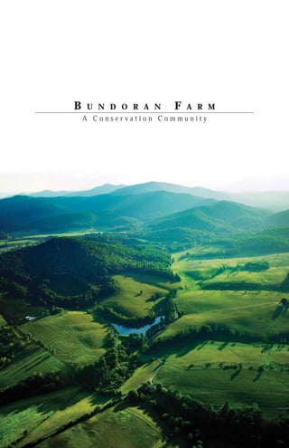
  • 4. BUNDORAN FARM INTRODUCTION In Southern Albemarle, on the upper branches of the Hardware River, lies Bundoran Farm. Home to a family of farmers since 1940, this valley is a place where the traditions of peaceful, sustainable country life have never gone away. The landscape is as varied as it is spectacular. The vast areas of verdant pasture, orchard, and well-managed forest are interspersed with riding and walking trails; and the breathtaking views of the farm, the valleys, and the Ragged Mountains in the distance cultivate a sense of a place that is enduring, timeless, and deeply rooted in tradition. Bundoran farm is comprised of 2,300 acres of rolling Albemarle County countryside located twenty minutes from Charlottesville and the renowned University of Virginia. The mindful stewardship of this land over the years has resulted in a place that would not be unfamiliar to a visitor from the time of Thomas Jefferson. Heavy stands of orchard grass and fescue cover a landscape of rolling pastures and secluded valleys and hollows. A fifteen-mile network of riding trails, sprinkled with benches and gazebos, leads visitors through a dazzling variety of mature Piedmont forest species, through and along the streams that tumble down through each valley. Two ponds provide a place for quiet reflection or fishing; and farm buildings and cottages dot the landscape, framing views that typify the slower pace and natural beauty of the Albemarle County lifestyle. Bundoran Farm is also the location of a new kind of rural community; one that presents a unique concept of farmland and forest preservation, combined with extremely limited residential development. In the case of Bundoran Farm, these principles result in a low- density community of approximately one hundred homesites, with the great majority of the farm’s acreage put under a unique regime of easements and deed restrictions to ensure the character, function, and maintenance of the farm in perpetuity. 4
  • 5. THE VISION Analogous to the principles of At the heart of the vision for Bundoran sustainability and the “triple bottom Farm is the idea of the “Working line,” the fundamental model of Landscape”. It is one of the key Preservation Development has been elements that distinguishes Preservation described as a “three-legged stool.” Development from other real estate Each leg of this stool represents a developments, even those that place different activity and a different lands in conservation or preservation constituency, and all three bear an covenants. Bundoran Farm is a working equal amount of weight. At Bundoran industry whose base of operations is Farm the three legs of the stool are: the topsoil. This is true of all farms (and when we speak of farms here, we speak 1. Farming – represented by broadly, including all properties that agricultural work and land make productive use of the land for management activities; pasturelands, woodlots, orchards, etc.). 2. Environmental Goals – expressed Unique to Preservation Development at Bundoran Farm by the work of is the fact that we are retaining that Audubon International; and working arrangement, so any successful 3. Home Development – exhibited approaches to developing the land must by home ownership and residency be consonant with this situation. This is on a working farm. not an approximation of living on a golf course or beside a national park. The Taken together, these three land has been and will continue to be interdependent legs of the stool manipulated, worked, and managed. As create a seat or platform that is such, it is not “natural” in the romantic both enduring, meaning capable sense of the word, which is to say it is of sustaining itself into future not pristine. These lands are and will generations, and replicable, serving as remain, however, earthy, beautiful, a model for similar developments that meaningful, and deeply rooted not only share this approach. in nature but also in millennia of human activity. Historically, the settlement of rural areas was accomplished by cataloging valuable resources such as water, soils, crops, and trees and then building where the land was least productive. The creation of the Bundoran Farm community followed a similar pattern. The result is not reflective of a particular idealogy, such as “New Urbanism,” “New Ruralism,” or “Conservation Development.” Rather, the design has been a process of rigorous analysis and a great deal of time spent in the field. To start, the project team designated areas for permanent protection and enhancement and worked backward to locate homesites that leave intact the most precious and fragile resources of the land. 5
  • 6. BUNDORAN FARM THE PROPERTY Bundoran Farm rests in the serene countryside of Central Virginia that Thomas Jefferson once described as “the Eden of the United States”. The 2,300 acres of Bundoran Farm comprise an extraordinary parcel of farmland, forest, orchards, cottages, and estates in southern Albemarle County. Straddling Plank Road (SR 692) west of US 29 South, as well as Edge Valley Road (SR 696) north of Plank Road, this scenic property is familiar to commuters and cyclists and to the Albemarle agricultural community as the previous home of the Albemarle County Fair. The farm’s landscape is varied, but in many ways typical of rural Albemarle. 1,000 acres, or roughly half of the farm, is wooded and a good example of well-managed mature Piedmont hardwood forests. Orchards bearing red and golden delicious apples cover approximately 200 acres. The remainder, roughly 1,100 acres, is fenced, well-watered pastures of orchard grass and fescue, and includes a cow-calf operation. The farm is also home to two estates; nine rental cottages; and numerous agricultural shops, barns, and other outbuildings. The property, assembled by continuous acquisitions of parcels over the past sixty years, has for decades embodied the value of stewardship of forest land. Very limited harvesting, as well as localized timber stand improvement and, more recently, aggressive invasive eradication work in conjunction with the Virginia Department of Forestry have resulted in large areas of exemplary mature forest. Likewise, the careful management of the farm over many years has resulted in pastures and orchards relatively free of many of the invasive-species challenges typical of nearby parcels. Management of cattle operations has been generally good, but uneven, across the various pasture areas. Over the past few years, pastures have been under several leases, with varying levels of commitment to rotational grazing and other best management practices. Baseline water testing for sedimentation and for marker species (“bug counts”), bears out this initial assessment, showing markedly reduced impacts in areas with faster rotation schedules. 6
  • 7. The farm has, over the past decade or so, moved in this direction and is expanding the lease area of the operator with the most fervent commitment to these principles. The farm abuts the southern edge of the Rivanna watershed, but the property itself drains to the Hardware River. In fact, one primary perennial stream is the Middle Branch of the North Fork of the Hardware River. In accordance with county and state policies, a wetlands delineation was performed on the property and submitted with the Final Plat Application. Two constructed ponds can also be found on the property. In one case, Lake Scogo, the dammed stream has sponsored a limited, though functional vegetated wetland. Intervention in this area will be include a long-term program of assessment and invasive- reduction. The thousand or so acres of hardwood forest include valuable habitat, as do the large grassland areas of the pastures. Initial assessment tells us that the primary habitat of value, in a regional perspective, is the large unfragmented areas of interior forest. Of special value are those on the west side of the property, which abut large contiguous acreage used for timber. However,this habitat faces issues typical of large forested parcels in the area, particularly those concerning deer population control. The property hosts an active hunt club, implementing a state-directed deer management assistance program (DMAP), a site-specific deer management program that increases a landowner’s or hunt club’s management options for control of deer populations. The team is committed to continuing the DMAP program in perpetuity. Other communities in the area that have not responded to this challenge at the time of development are often forced to do so later, with concurrent disruption and expense. 7
  • 8. BUNDORAN FARM THE REGION Albemarle County is located in Central Perhaps the most noted characteristic Virginia and within the Piedmont of the region is its exceptional natural 29 Plateau. Boasting a rich history, beauty and magnificent surroundings. Albemarle County is known worldwide Situated in the foothills of the stunning as the home of Thomas Jefferson’s 240 Blue Ridge Mountains, the area draws CROZET Monticello, James Monroe’s Ash Lawn- on the best traditions of Virginia country 250 IVY 250 Highland, and Patrick Henry’s Red living and its distinctive and individual 29 Hill and is within close proximity to lifestyle. Located just minutes from 64 UVA 250 some of the most notorious battle sites historic Charlottesville, Bundoran’s DS ROAD DOWNTOWN of the Civil War, including Richmond, residents will be part of this progressive, OO W CHARLOTTESVILLE K 64 DIC Wilderness, and Appomattox. vibrant community which offers fine art museums, an array of performing . RD BATESVILLE Albemarle County enjoys a modified arts venues, annual equestrian events, P GA RS continental climate with mild winters LO and the nationally recognized Virginia TAY VALL GE EY 29 ED and mild to humid summers. The Film Festival. In addition, residents and AD RO average temperature from June to their guests will enjoy experiencing the PL G AN UR K RD HB . NORTH GARDEN NC August is 75 degrees and the average area’s many award-winning vineyards, LY OL D 20 712 for December through February is 37 fine antique shops, and the University of degrees. Average annual rainfall is Virginia’s Academical Village. 47.29 inches and snowfall is 24.2 inches. Albemarle County was formed in 1744 from Goochland County and named for William Anne Keppel, the second Earl of Albemarle, titular governor of Virginia from 1737 to 1754. In 1761 the county government was moved to Charlottesville, which was established as a town in 1762. Albemarle County is approximately 110 miles southwest of Washington, D.C., 70 miles west of ALBEMARLE COUNTY, VIRGINIA Located in the Piedmont region of Central Virginia Richmond, and 115 miles northeast of Roanoke. The county surrounds the city of Charlottesville and shares the University of Virginia campus. The majority of the county’s 721 square miles are designated for rural area protections, with just over 72 square- miles, or roughly 10 percent, set aside for urban-residential, commercial, and industrial land uses. As of 2007, 895 farms were operating in the County, accounting for 158,317 acres, or a little over 34 percent of the County’s total land area. Farming practices are diverse and include cattle, equestrian, and even buffalo operations as well as a number of orchards and a rapidly growing number of vineyards. BUNDORAN FARM SE portion of Albemarle County, Piedmont Upland Physiographic Region 8
  • 9. tai ian un ch ns Mo pala Ap JAMES RIVER Charlottesville NORTH 9
  • 10. BUNDORAN FARM THE HISTORY The rolling hills and valleys of Bundoran Farm are the product of billions of years of natural history and thousands of years of human use. It has known landlocked mountains reaching higher than the Himalayas; it has been a coastline, a seabed, and a featureless plain. The land has been nourished with minerals washed from rivers and mulched with the rich compost of innumerable species of plants. The area’s rivers have revealed its valleys as mountains have slowly risen again, and may still be rising. Even before Europeans arrived, the land around Bundoran might have been cleared and cultivated. Within a virgin forest of magnificent American Chestnut, whose trees towered as much as 160 feet above the ground, the ancestors of the Monacan Indian Nation may have maintained fields near villages here. Although we have no certain proof, the rich soils still present today suggest that natives might have settled and cultivated fields in the bottom lands of Bundoran. They would have burned such fields annually in order to keep them open, either for agriculture or to attract wildlife. And these first peoples likely would have cultivated tobacco here, which was sacred to them, and probably taught visitors how to do the same. Bundoran’s topsoil has been in nearly constant production since that time, including tobacco which was a popular crop even among the earliest settlers. Unfortunately, these pioneer farmers did not necessarily understand the benefits of growing their crops in line with the land’s contours. Moreover, tobacco does not grow well in soggy soil, so it appears that early tobacco farmers dug deep ditches down the hillsides, perpendicular to the contours, to drain water from the rolling fields. Such practices put the topsoil at risk. And this, combined with the heavy toll tobacco takes on the soil’s nutrients, meant that farmers had to turn to other other crops that were better suited to the conditions, such as corn and fruit. Luckily the hills around Bundoran are ideal for growing apples. Each spring, the cool air sinks along the slope of 10
  • 11. the hillsides and drains away from the new apple buds, preventing them from freezing. The lower grounds have always provided perfect pasturelands for livestock. The land itself was discovered by settlers in the early 18th century when scouts following the North Fork of the Hardware River determined that the area we know as Bundoran Farm was a prime site for settlement and called it North Garden. Other westward explorers following the South Fork of the Hardware River named that region South Garden. North Garden and South Garden can be geographically described as two natural “bowls” with higher ground between them. The fertile bottomland soils surrounding mountain forests and the adjacent Hardware River provided the basic needs for early settlers and opportunities to trade and prosper. After the Revolutionary War, more and more settlers crossed the Blue Ridge Mountains of Virginia to live in the Shenandoah Valley and Trans-Allegheny region. A way of transportation connecting the east and west was needed to accommodate the increasing population, and so the Staunton or Rockfish Gap Turnpike was authorized in 1818. Bisecting the southwest quarter of the county, the turnpike linked the port of Scottsville on the James River directly with the Shenandoah Valley and its many agricultural products. The high ground between North and South Garden emerged as a regional hub when the new Staunton or Rockfish Gap Turnpike created an intersection with Old Lynchburg Road. Locals called it the Crossroads. In 1818, the Sutherland family built the Crossroads Tavern on the corner of Rt. 29 and Plank Road (SR 692) for travelers and farmers using the Staunton and James River Turnpike. The farm as we know it today was originally purchased by the Scott family in the 1940s, was assembled by continuous acquisitions of parcels over the past sixty years, and has for decades been a testament to the value of land stewardship. 11
  • 13. SITE INVENTORY & ANALYSIS A number of inventory and Field visits and on-site reconnaissance analysis studies were conducted were necessary to investigate design pertaining to the physical opportunities and constraints and to elements of the farm property. familiarize the team with the property. These studies, and the resulting Assessment of natural and man-made findings, assisted the team in factors and land uses were all part of making solid, justified, and the site investigation. The following appropriate planning and design analysis describes the implications and decisions for the project. characteristic of each physical element. PROCESS 14 EXISTING ROADWAYS 16 PUBLIC VIEWSHED 17 STREAM CORRIDORS AND WETLANDS 18 PRODUCTIVE FARMLAND 19 FOREST/WILDLIFE HABITAT 20 MOUNTAIN PROTECTION ZONES 21 PRESERVATION AREAS 22 POTENTIAL DEVELOPABLE AREAS 23 HOMESITES 24 SLOPE 25 ASPECT 26 13
  • 14. BUNDORAN FARM PROCESS “A SUBTRACTIVE PROCESS” On top of these, the design team then mapped critical natural resources of all The design of the Bundoran Farm kinds, including forest and meadow community has embodied the notion habitats; water resources such as of a bottom-up approach. The streams, wetlands, and ponds; and design team came to the land with many individual areas particularly a great deal of combined experience threatened by development or farming in land-planning, conservation, and activity, such as steep slopes, micro- community development, but with no habitats, and wildlife corridors. This preconceptions. analysis extended to improvements and common area amenities such as trails, The design process at Bundoran recreation areas, and scenic views. Farm began with the land itself. An exhaustive, iterative process, involving Finally, the selection of homesite numerous professionals from the fields locations and the design of the final of landscape architecture, engineering, homesite is the result of the culmination farming, forestry, and real estate of this rigorous anaylsis and assessment development was applied. In the case process, coupled with considerable time of the 2,300 acres comprising Bundoran spent on the ground. Farm, this process took the team over a year to complete and reflects a philosophy to “let the land tell you what to do.” First, the areas of the farm under cultivation or pasture were cataloged and evaluated, with the goal of identifying the most productive, economically viable, and sustainable agricultural land. The key here was to protect large, contiguous, accessible areas with good soils, shade, and water. At Bundoran Farm, this analysis extended to the identification and protection of important stands of timber and forest environments. Next, the design team overlaid a “viewshed” analysis, documenting areas of the farm that are visible from public and private roads, homesites, and adjacent properties during different seasons in order to determine areas that should be preserved to maintain the scenic and rural character of the property. 14
  • 15. 15
  • 16. BUNDORAN FARM EXISTING ROADWAYS LAY LIGHTLY ON THE LAND The existing roads, paths, and trails were located, studied, and whenever possible, incorporated into the engineered road system of the Farm. The end results are roads that “lay lightly on the land” as well as minimal soil disturbance. EXISTING ROADS -State Roads (Plank, Edge Valley) -Existing Paved/Treated Roads -Existing Farm Roads (dirt/gravel) EXISTING STATE ROADS EXISTING FARM ROADS EXISTING PAVED ROADS Red - Existing Roadways 16
  • 17. PUBLIC VIEWSHED PROTECTION OF THE PUBLIC VIEWSHED The land of Bundoran Farm is an iconic image of Albemarle County. A top priority was to protect the visual character of this landscape. A series of studies were undertaken to fully understand what people see and experience as they travel along the public roads and through the pastures and meadows of the farm PUBLIC VIEWSHED Yellow – Areas Visible From Public Roads During Non-Winter Months. 17
  • 18. BUNDORAN FARM STREAM CORRIDORS & WETLANDS The streams, ponds, and wetlands found at Bundoran Farm are valued, sensitive resources. In addition to providing water for agricultural and recreational activities, the water courses lead to the Hardware River, the James River, and eventually to the Chesapeake Bay. Ongoing water quality testing is underway to fully assess the impacts of the development and natural resource management concepts. PROTECTION OF STREAM CORRIDORS & WETLANDS -Two major constructed ponds -Stream corridors delineate perennial / intermittent watercourses -Preserves on and off site water quality -Creates abundant wildlife habitat CONSTRUCTED POND STREAM CORRIDOR CONSTRUCTED POND Light Blue - Stream Corridors & Wetlands 18
  • 19. PRODUCTIVE FARMLAND PROTECTING THE FARM A major focus of the design process was protecting and preserving the Bundoran landscape. This was accomplished in part by placing all areas of the farm that are actively managed for agriculture practices under agriculture easement. Under guidance from a steering committee and an on-site Natural Resources Manager, the resident farmer is allowed use of this land for cattle, orchards, or other farm use, employing practices approved Audubon International for Bundoran Farm. Most forested areas of the property are under conservation easement, which commits the managers to maintain the forest under a professionally-developed plan for timber stand and wildlife preservation. Individual homesites are located in the seams between these important agricultural and forest areas, typically PASTURE/CATTLE in locations with good access and incomparable views. In the end, with many individuals owning a piece of the property, the farm still ORCHARD provides large contiguous areas for pasture, recreation, and forestry which guarantee the future viability of all these functions. Furthermore, road access is not designed to minimize expense, an approach that typically results in short culs-de-sac and homes located close to public roads. Rather, Bundoran Farm accepts unusually long roads, when required, to minimize fragmentation or other disturbance of agricultural or forestal uses. In return for allowing easements on their property, homeowners receive two benefits. First, though they may have bought only a few acres, they are welcome to use the entire farm property. Second, the maintenance of this land as farmland protects the investment of the homeowner, as there is no possibility of a neighbor changing the character of adjacent property to non-agricultural use. Large, contiguous areas of productive farmland are essential to maintaining the local economy, culture and Light Yellow – Pasture / Cattle landscape. Bundoran Farm’s pastures Operations and orchards not only help to enable Orange – Under Orchard Leases more efficient agricultural operations, Essential to maintenance of local they also protect the primary public economy, culture and landscape. viewsheds. Principal public viewsheds. 19
  • 20. BUNDORAN FARM FOREST/WILDLIFE HABITAT FOREST STEWARDSHIP Recognizing that this land is part of the larger ecosystem of the area’s Piedmont forests, Bundoran Farm will continue in its commitment to sustainable, long- term thinking in forestry management. While management plans that have been in place for decades will continue to be followed and updated, the Bundoran project has partnered with Audubon International to create a comprehensive plan for the property with the goal FOREST/WILDLIFE HABITAT of maintaining and improving the important functions of this land in the areas of water quality and wildlife habitat. Large portions of forested land on the site will remain as preserves for wildlife; and the streams, ponds, and wetlands will be monitored, maintained, and protected for future generations. A significant component of the land and natural resource management includes native wildlife habitat protection and enhancement. Large contiguous areas of Piedmont hardwoods have been mapped and will continue to benefit from a comprehensive forest management plan. These vast acreages provide a wonderful and diverse habitat for plants, animals, and human recreation. PLANT & ANIMAL HABITAT Although a number of struggling native species such as the white-tailed deer have recovered, losses of other native plants and animals are a significant concern. For example, a number of eastern migratory songbirds are in decline, likely due to human activities. Those declines are caused by several factors such as fragmentation of habitat-- the dividing of large areas into smaller parcels, and the resulting disruption of forest cover. As stated in the Albemarle County Comprehensive Plan: “Wildlife is a renewable natural resource which requires both protection and harvesting for proper management. The mountainous areas of the County contain the more dense populations of wildlife...” By planning for the active management and protection of wildlife habitat, the design team sought to Green - Forest/Wildlife Habitat position Bundoran Farm as a model of this philosophy. PRESERVE FOREST/WLIDLIFE HABITAT Because of its high value for wildlife habitat the main focus was on the preservation of: Large Contiguous Interior Forest Areas Adjacent to Neighboring Forests Areas more threatened than edge habitat. 20
  • 21. MOUNTAIN PROTECTION ZONES PROTECTION OF MOUNTAIN LANDSCAPES Albemarle County’s mountains have MOUNTAIN PROTECTION ZONE been and continue to be a source of income, natural resources, scenic beauty, and recreation. Directly and indirectly, the County’s mountainous areas provide tens of millions of dollars to the local community in employment, tourism, and agricultural and forest products. Beyond the economic benefits, the mountains provide important natural functions, such as provision of clean water, contributions to healthy air, and habitat for many plant and animal species. To many residents, the “blue” backdrop of the mountains gives Albemarle County its sense of place, a quality that makes this area special and consistently ranked among the top places to live in the United States. Concerns regarding disturbance of steep land become pronounced in mountain areas due to generally shallow soils and length of grade on side slopes. Soil erosion, surface water runoff, and septic system contamination are amplified in these areas. Forest cover is the optimum land use for minimizing soil erosion and maximizing water quality. Soils on steep slopes are typically more erodible than in other areas. Inaccessibility and isolated location of development sites in mountain areas necessitate longer driveways and access roads disturb many times more land area than a dwelling itself. Because of their high ecological and cultural value as well as their propensity for soil erosion, the mountainous areas at Bundoran Farm were removed from the area being considered for the development of homesites. Blue – Mountain Protection Zone 21
  • 22. BUNDORAN FARM PRESERVATION AREAS COMBINE PRESERVATION AREAS By overlaying the previously outlined elements we were able to determine the areas suitable for development and those that should be preserved. This subtractive approach allowed for the further refinement of the initial analysis of the property and provided the outlines used for the determination of the developable areas. Using this subtractive approach versus the standard by-right development, we Pasture/Cattle Operations were allowing the existing landscape to dictate the location of the developable areas. By mapping the areas containing critical natural resources of all kinds, the team was able to determine those areas of the landscape with the highest FOREST/WILDLIFE cultural and ecological value and those that were suitable for further analysis HABITAT and refinement for the creation of homesites. EXISTING ROADWAY STREAM CORRIDORS & WETLANDS UNDER ORCHARD LEASE MOUNTAIN PROTECTION ZONE PUBLIC VIEWSHED Red - Existing Roadways Yellow – Areas Visible from Public Roads during non-winter months Light Blue - Stream Corridors & Wetlands Light Yellow – Pasture/Cattle Operations Orange – Under Orchard Leases Principal public viewsheds Green - Forest/Wildlife Habitat Blue – Mountain Protection Zone 22
  • 23. POTENTIAL DEVELOPABLE AREAS HOMESITE SELECTION & REFINEMENT After the project team identified and overlaid all of these resources on a map, what was left was the area to be considered for development. A pattern of “seams” began to appear, between forest and field, between wetland and upland. Within this initial “developable area,” homesites were defined, REMAINING AREAS paying close attention to the location to minimize intrusion on the natural landscape. As these site selections were continually refined over many months both in the office and in the field, functional elements like roads, driveways, and septic systems were considered. Lot lines were drawn after the fact to accommodate zoning and to delineate areas of oversight and easement for each homesite. The result is a selection of homesites, at a very low overall density, each of which share common recreation areas, viewsheds, and resources in a way that makes each homesite part of a larger whole. Each lot is also connected to many miles of trail and common resources which, in a more typical development, would require ownership of a much larger parcel. HOMESITE SELECTION CRITERIA -Areas between and beyond zones targeted for preservation. -Beyond public viewshed -Leaving contiguous productive farmland -Removed from prime habitat -Far from water/stream corridors. Yellow – Potential Developable Areas Remaining After Overlay of all Analysis Layers 23
  • 24. BUNDORAN FARM HOMESITES HOMESITE AREAS REFINED After appropriate areas for homesites were identified outside of the preservation zones, the selections were further refined by walking the land. Key selection criteria for individual homesites included views, privacy, access, and ease of building. Options were further reduced to accommodate landscape features, farm activity, road access, and environmentally sensitive zones. HOMESITES Yellow – Refined Homesite Locations 24
  • 25. SLOPE Slope plays a considerable role in determining land use. In terms of the envisioned programming for Bundoran Farm, agricultural fields require gently sloped areas while housing, trail, and wildlife habitat may best be situated on steeper zones. For analysis purposes, site slopes fall into one of four distinct gradient ranges; 0 – 15% slope, 15 – 25% slope, 25 – 40% slope, 40 - 50% slope, and greater than 50% slope. The vast majority of the open land is in 0 – 15% and 15 – 25% slopes. There are some wooded areas where these modest slopes are found, but they consist of small pockets of a few acres here and there on upland knobs and low boggy areas in the center of one or more ravines. While some areas within the wooded ravines have rather gentle slopes, they typically contain grades in the 25 – 40%, 40 - 50%, or 50% + range. For a property of this size, a very low percentage of the terrain is in critical slopes of 25% or greater. These steep slopes occur mainly in the mountainous forested areas. A small portion of the critical slopes are man-made; created as a by-product of roadway construction performed over the years. With the exception of the farm lanes, the site remains largely in its natural topographic state. 0 - 15% Slope 15 - 25% Slope 25 - 40% Slope 40 - 50% Slope 50% + Slope 25
  • 26. BUNDORAN FARM ASPECT Aspect refers to the direction in which terrain is oriented in relation to the solar position. This determines vegetative plant growth, plant species, and microclimatic conditions throughout the day and year. This positioning also helps us understand the most useful and valuable places to locate buildings. Solar analyses, according to the slope aspect, were developed for the property on four different days (corresponding to winter and summer solstice and the spring and fall equinoxes), and at three different times of day. JUNE 21 (summer solstice) 8 a.m. | 12 p.m. | 5 p.m. MARCH/SEPT. 21 (spring/fall equinox) 8 a.m. | 12 p.m. | 5 p.m. N DECEMBER 21 (winter solstice) 8 a.m. | 12 p.m. | 5 p.m W E E V E M N O I 6p R N e 21 N Jun G I N 21 pt. G Se 21 / rch Ma 1p 1 er 2 emb Dec 9a S 26
  • 27. JUNE 21 (SUMMER SOLSTICE) 8 A.M. 12 P.M. 5 P.M. MARCH/SEPT. 21 (SPRING/FALL EQUINOX) 8 A.M. 12 P.M. 5 P.M. DECEMBER 21 (WINTER SOLSTICE) 8 A.M. 12 P.M. 5 P.M. 27
  • 29. SITE DESIGN ELEMENTS The magnificence of Bundoran Farm is The various elements that were planned representative of the distinct landscape and designed fall into one of two levels of Albemarle County. The challenge of development: of designing on such a spectacular piece of property was overcome by not OVERALL MASTER PLANNING: elements only ensuring that the overall master that emphasize the Bundoran Farm planning placed the development areas property as a whole, allowing for the lightly on the land but also that the preservation of the unique Piedmont design and planning occurred at various working farm landscape character. scales. By moving from a coarser master planning scale to a finer site SITE DESIGN: elements that specifically design scale, it allowed us to capture focus on the design and development the overarching character of Bundoran of a single lot either for a community Farm at every level of development. building such as the sustainability center or an individual homesite. This The impacts of development were scale of development enables us to focus alleviated by both the community in on the small details used to create a design process (in the form of sensitive unique homesite while maintaining the roads and maintenance of rural overarching goals of preservation and character in all common features) and active use of the land. by vigorous enforcement and promotion of standards for sustainability in construction, landscaping, and use of both individual and easement land. EASEMENTS 30 PROPOSED ROADWAYS 32 PHASING 34 MASTER PLAN 35 SUSTAINABILITY CENTER PROCESS 36 SUSTAINABILITY CENTER DESIGN 38 HOMESITE DEVELOPMENT 40 PRIVATE RESIDENCE 42 AUDUBON 44 29
  • 30. BUNDORAN FARM EASEMENTS CROSS EASEMENTS & RESTRICTIVE These easement areas are defined PROVISIONS OVERVIEW irrespective of individual parcel boundaries, and every lot in the community includes acreage (usually Preservation Development integrates the majority of lot acreage) under a small number of homes positioned common management. As a result, strategically within an operating farm, these areas may not be built upon by pasture, and/or timberland. The owners, although driveways and sub- farmland is protected permanently grade utilities may be introduced with by a deeded easement system. This permission. Each owners’ “Public “farmbelt” easement not only protects Greenbelt” acreage is agglomerated the farmland from other uses, it with their neighbors’ land into large explicitly grants farmers the right to contiguous areas of well-managed farm the ground as they reasonably see land, where cattle may graze, grapes fit. The remaining land is then examined or apples may be grown, or where to determine what parts should be ecological reserves such as wetlands permanently conserved in their natural restorations may take place. state. Lots suitable for development are finally located within these “seams.” PRIVATE GREENBELT Within these lots are relatively small, At a smaller scale, each lot contains strategically located homesites that an area of approximately two acres combine attractiveness of location and designated “Private Greenbelt.” These view with compatibility with farm areas, which surround the intended activities and conservation. Each is home site, are not part of the Public associated with a larger greenbelt area, Greenbelt, in that only the lot owner the steward’s “lot.” Each steward has access. The use of the land in this purchases a specific area for a homesite, area is controlled by the homeowner, along with a larger portion of greenbelt, but construction is not permitted. The and a share of the farmbelt as well. intention is to give the owner a private While the homesite and lot remain for landscape, some “elbow room” in the steward’s sole use, the majority their forest or field landscape. In this of the conservation lands is given area more intensive landscape work, over to the community for passive such as walls, fences and gardens are recreation. Each of the owners holds permitted. easements over the other areas and together endorse the farm operations. HOMESITE This arrangement provides capital and incentives for profitable, productive At the other end of the spectrum is the use of the land. The considerable “Homesite,” typically 1/2 to 1 acre on value added to each homesite by each of Bundoran Farm’s 108 potential the design and protection of the lots. These areas are carefully located community permits lower density while for minimal impact on the visual maintaining a satisfactory financial character and agricultural operations return. This density cannot be too of the farm. While these zones are low, however, or the critical mass that specifically exempted from the makes a “community” and supports it easement restrictions on the Public financially is lost. and Private Greenbelts, building activity is still regulated. The development at Bundoran Farm employed the following three types of Within the Homesite envelope, a easements. “Development Zone” is defined where home construction is PUBLIC GREENBELT anticipated, and any construction must comply with design guidelines. The most prominent features of These guidelines are defined by the Bundoran Farm are the nearly 1,000 “Bundoran Farm Pattern Book,” a acres of mature hardwood forest, survey of architectural and landscape and the 1,100 acres of high-quality approaches suitable to the farm open pastures. Together these zones landscape, and by the “Bundoran account for over 90% of the land area Farm Sustainability Guide,” which of the property, and their preservation outlines minimum standards and and ongoing management are the opportunities for ecologically sensitive essential goal of all plans related to the and resource-efficient design. development. Critically, the applicability of specific elements of these guidelines is defined The great majority of these lands are at the level of every individual lot designated as “Public Greenbelt,” in a “Lot Portfolio.” This two-page meaning that all members of the summary of each lot at Bundoran community have access to these Farm reviews specific characteristics areas--to the extent that access will of the location, hydrology, solar not impinge on agricultural work-- orientation and agricultural operations but the management of these lands on the lot, and fine tunes the is in professional hands, guided development patterns of the farm to by a committee of developer and these characteristics. homeowners. 30
  • 31. CROSS EASEMENTS & RESTRICTIVE PROVISIONS Each owner has right to passively use the entirety of the property (own 5 acres, experience 2,300 acres); Each owner has right to protection of all greenbelt/farmbelt land; Penalties are large and lienable; Property Owners’ Association (POA): has specific dues and responsibilities, such as maintaining the forest and trail system and renewing and plowing roads; All owners look out for environment and act individually or through the Farm Management Committee; and Design Committee facilitates development consistent with established vision. 31
  • 32. BUNDORAN FARM PROPOSED ROADWAYS ROAD LAYOUT IN THE FIELD The result of roadways designed with deference to the landscape and with the siting of homes means more linear footage of road. The project team has attempted to mitigate this impact by designing very low-impact roads and by integrating stormwater management into the agricultural functions of the land. The country roads have been designed to be as narrow as possible to retain the natural contours and water flow of the landscape. Roadways are private as allowed by special permit in Albemarle County. The design team was able to provide narrower roads of 14 feet in width which are more in keeping with the farm roads that were present on the site prior to development. Realizing it may be difficult for two vehicles to pass on such a road, grass shoulders were designed to handle this scenario as well as blend into grass swales designed for stormwater attenuation. The standards for private roads (as opposed to those of the Virginia Department of Transpiration) allow not only for narrower road widths but also steeper grades and tighter turning radii which, aside from keeping with the aesthetic of the existing farm roads, also reduce the overall cost of road infrastructure. In the case of Bundoran Farm, approximately $800,000 was saved in earthwork alone, not to mention the cost savings from not having to construct curb-and-gutter and roads with more sub-base and pavement surface. CARPENTER ROAD 32
  • 33. sr STATE ROADS p PAVED/TREATED ROADS FARM ROADS fr BRIDGES b CULVERTS c 33
  • 34. BUNDORAN FARM PHASING PHASED DEVELOPMENT TO MEET MARKET DEMAND AND REDUCE INITIAL TAX BURDEN The Bundoran farm property is zoned Rural Area, the tax rate for which is considerably less than that for residential use. Due to the size of the project and anticipated market demand, the conservation community was developed and platted in two phases to reduce the initial real estate tax to only that for roughly half the number of total residential lots that would ultimately be recorded. PHASE I PHASE II 34
  • 35. MASTER PLAN PROPOSED MASTER PLAN 96 Total Lots 12 “Dependencies”: Additional Restricted Development Right Attached to Primary Lots Homesites arranged to minimize disturbance Lot lines configured to allow large contiguous cross-easements 35
  • 36. BUNDORAN FARM SUSTAINABILITY CENTER PROCESS Every lot and every home at Bundoran is unique; but just as every farm building in history has responded to the climate, topography, resources, and traditions, the homes and community buildings on Bundoran Farm will reflect the values of the area’s agrarian legacy, respond to environmental changes, and be rooted in their cultural heritage. To fully address the variety of issues related to designing a sustainability center based around an agricultural development, the design team took cues from both the property and from historical settlement patterns. By researching historical agrarian development patterns the team was able to better understand the relationship between the development and the agricultural landscape. Additionally, much as with the overall master planning process, a subtractive process was used along with a thorough analysis of solar orientation, wind, slopes, soils, vegetation, and wildlife to determine the layout of the sustainability center. Based on these considerations, a pattern began to emerge that remained throughout the design process and ultimately informed the design of the sustainabilty center. This pattern can be seen in the way the center is placed along the ridgeline creating a curved pattern similar to that of an amphitheater. Indeed, according to A History of the Valley of Virginia, Farms in the western parts of Pennsylvania and Virginia bear a striking resemblance to an amphitheater. The buildings occupy a low situation and the tops of the surrounding hills are the boundaries of the tract… everything comes to the house down hill.” 36
  • 37. INITIAL SKETCH OF CENTER LAYOUT 1 REVISED LAYOUT CONCEPT 2 FURTHER REFINED LAYOUT 3 37
  • 38. BUNDORAN FARM SUSTAINABILITY CENTER DESIGN place for local and farm-related concerns; to enlighten, encourage, The Sustainability Center, formally and inform regarding Preservation known as the Baldwin Center Development and the practical side of for Preservation Development, is sustainability, environmental action, the nucleus for farm operations, and the role of the farm in modern environmental monitoring and life. education, and homeowner interaction at Bundoran Farm. It demonstrates SHADE TOLERANT NATIVE PLANT NURSERY how buildings, landscape, and people DEMONSTRATION SHED WITH PHOTO-VOLTAIC ROOF PANELS interact in a sustainable manner; exemplifying the governing ideas of MAINTENANCE BARN WITH RAINWATER CISTERN the larger farm at a smaller scale. At the broadest scale, the Center will serve as the social and informational hub for “BARN YARD” Bundoran Farm. As the headquarters for the Baldwin SUSTAINABILITY CENTER + CONFERENCE BUILDING Center for Preservation Development, LOG CABIN a non-profit foundation whose (WOOF WORKING DEMONSTRATION BUILDING) VEGETABLE + HERB GARDEN mission is to showcase innovative FARM OPERATIONS OFFICE practices in agricultural preservation, environmental stewardship, and sustainable ground, the building SUSTAINABLE HARVESTED HARDWOOD NURSERY houses members of the Bundoran Farm development, management, and real estate sales teams. In addition to hosting the Inaugural Baldwin Center Symposium, “Residential Development and the Working Landscape” (attended by over fifty participants from across the country), a number of groups with missions and goals consistent with the Baldwin Center’s have enjoyed gathering here. Equally important is how this new facility along Edge Valley Road has become the place to find all there is to know about Bundoran Farm and how to become a part of it. The Center serves: Residents – as training, orientation and education, a source of design and builder information, and as a gathering place on Bundoran Farm Farmer/operations – as a source of MAIL DEPOT + COMMUNITY RECYCLING CENTER best practices, recommendations and research for this Farm Developers – as a “proof of concept” for Preservation Development, and a source of information, tools, and advice. Neighbors and the general public – As an education center, a gathering 38
  • 39. THE BALDWIN CENTER FOR PRESERVATION DEVELOPMENT 39
  • 40. BUNDORAN FARM HOMESITE DEVELOPMENT EVOLUTION OVER TIME The following conventions identify site-specific development restrictions. Bundoran Farm houses will be HOMESITE designed to fit into and work with the (1) Lots and Homesites: Each existing landscape. The traditional and lot at Bundoran Farm contains a cherished houses of the region exhibit predetermined homesite as shown a subtle sense of existing within the on the Lot Portfolio. The remainder landscape. Care and responsiveness to of each lot contains Farmbelt and FARMBELT/GREENBELT EASEMENT the use, slope, and character of the land Greenbelt easements that are are fundamental principles guiding the accessible to residents and guests of placement of buildings, the locations Bundoran Farm but are managed by of drives, and the definitions of yards. others. Throughout Albemarle County, there is a rich history of patterns that grew (2) A Development Zone has been out of an intuitive understanding of the identified within each homesite. relationship between the house and the The Development Zone defines the land. absolute boundary for any potential disturbance on the site, other than for LOT Homes will be built in carefully selective clearing or septic purposes, chosen development zones that sit in unless otherwise approved by the strategically located homesites within Bundoran Farm Design Committee. larger property boundaries, (greenbelt/ The intent of the Development Zone farmbelt) ranging in size from 2 to 200 is to assure that the most sensitive acres, with an average size of 20 acres. areas of the site are preserved while The lots themselves have been so chosen allowing flexibility in determining the to ensure that the diverse activities of location of the house. this working farm and managed forest are not in any way compromised, so (3) The Selective Clearing Zone that the land, under cultivation already encompasses all land within the for centuries, can remain productive in homesite not occupied by the perpetuity. Development Zone. The Selective SELECTIVE Clearing Zone establishes a CLEARING ZONE Historically, many houses have evolved second tier of preservation for the over time, some starting as a rough lot. In general, all vegetation and hewn log structure or a wood frame topography in the Selective Clearing cottage. Later, a more refined and Zone should be preserved with the DEVELOPMENT ZONE larger main house is constructed that exception of the establishment of may have had rooms added as the partial views and utility routes. family grew. Outbuildings that served utilitarian needs of the rural household created yet another quality recognized as part of the physical and cultural fabric of Albemarle County. Home owners at Bundoran Farm are encouraged to build and design in much HOMESITE the same way – thoughtfully, carefully, and incrementally – responding to a family’s needs and an evolving understanding of the land. Houses at Bundoran Farm are designed so they can grow over time; the body of the house is largely linear in form and narrow in depth in order to work with the land and to minimize grading and level changes. Bundoran Farm houses use traditional and familiar proportions, materials, colors, and detailing. 40
  • 41. Bundoran Farm homesites are carefully placed so they engage the surrounding environment without compromising it. Each homesite was individually evaluated for its beauty, buildability, privacy, and potential impacts on the overall community. Throughout the property, the homesites generally fall into one of three categories: RIDGE VIEW HOMESITES Homesites providing long views of the ridges of the surrounding Blue Ridge and Ragged Mountains over Bundoran Farm’s pastures and forest. MEADOW VIEW HOMESITES Homesites providing expansive and protected views of meadows, forest, lakes, and streams within Bundoran Farm’s landscape. FOREST PRESERVE HOMESITES Secluded homesites nestled within mature, well-managed stands of native hardwood trees near Bundoran Farm’s extensive trail network. While each homesite throughout the farm is unique, the approaches to designing and building on each homesite are similar. The preservation of the woodlands and wildlife habitat found through much of Bundoran Farm is crucial to sensitive development of the landscape. Development patterns must protect as much of the existing tree stands and existing vegetation as possible through thoughtful house placement, delicate grading, and efficient use of space. A smaller envelope of disturbance may be achieved by organizing the layout of the house and grounds in a linear fashion running with, and parallel to, the contours of the existing slope of the land. 41
  • 42. BUNDORAN FARM PRIVATE RESIDENCE FIRST RESIDENTIAL LOT DEVELOPMENT AT BUNDORAN FARM The decision to build a home at Bundoran Farm reaches beyond the desire for a new house. This commitment signifies the beginning of a lifestyle and of a meaningful relationship with the land.This environment is not a typical subdivision or estate development. It is a working farm, surrounded by vast managed forests, the whole ecosystem supporting a tremendous variety of important uses, including agriculture, recreation, and wildlife habitat. The quality of this unique landscape as a place for life experiences and an investment depends on decisions we make. These decisions will reverberate in this landscape for generations to come. McKee Carson worked in conjunction with a local builder on the design and development of the first residential lot at Bundoran Farm. For individual house sites, careful consideration of solar orientation, prevailing winds, creeks, sloping hillsides, and desired views will help to preserve this delicate environment. This information will help to orient the building to take advantage of natural drainage, daylighting, solar energy, natural ventilation, scenic views, and the ability for surrounding vegetation to offer protection from the winter wind and summer sun. Given the sloping terrain of many sites in Bundoran Farm, it is advantageous to orient the massing of the house and grounds parallel to the contours of the slope. For the design of the plantings surrounding the house the intential was for the plant pallete to blend seemlessly into the Bundoran Farm landscape and incorporate native tree and shrub species, including in many instances those already found on the farm. 42
  • 43. 43
  • 44. BUNDORAN FARM AUDUBON BUNDORAN FARM DESIGNATED A CERTIFIED GOLD AUDUBON INTERNATIONAL SIGNATURE SANCTUARY Audubon International (AI) has been key to the design of this project. An offshoot of the Audubon Society of New York, AI has worked for years with developers to assist in the design of systems that work with, rather than against, the environment. Best known for their work in the certification of sustainable golf courses, AI sought to use Bundoran Farm as a model for the application of their new “Signature Sanctuary” program. Supplying knowledgeable and experienced freshwater ecologists, environmental toxicologists, wildlife biologists, and other experts, AI worked with McKee Carson to help shape both the overall development plan, and many specific elements of the design, from stream crossing strategies to design of interior forest preserves and watercourse buffers. Most importantly, a Natural Resource Manager in residence at Bundoran Farm will implement the Ecological Design and stewardship plans for the community. This work will consist of both mediation between farm operations and the environment, and long-term ecological restoration and preservation projects on the property, as well as education and outreach to help property owners and the community make responsible choices. “The Bundoran Farm project is unique to all other Gold Signature projects that we are involved with around the globe with respect to the commitment made to include working agriculture as an integral part of the development process” said Ronald G. Dodson, President and CEO of Audubon International. “We are proud and excited to be part of the Bundoran Farm project because we believe it will become not only a Certified Audubon Gold Signature project, but it will be an internationally significant demonstration effort in sustainable development” concluded Dodson. The Audubon Gold Signature Program is considered the leading not-for- profit environmental education and certification program in the world and has garnered praise and awards from international, national, state, and local governmental agencies; other not- for-profit organizations; businesses; universities; and citizens around the globe. Audubon has established a permanent presence at Bundoran Farm. This is the first time that they have engaged in a partnership with an agricultural project. From their facilities on the 44
  • 45. property, located in the Robert Baldwin Center for Preservation Development, AI will conduct research as well as provide analyses and recommendations that will assist the farm, orchard, and timber managers to protect water quality and prevent topsoil erosion. The goal is to protect, preserve, and enhance the environment of this farm, not merely as an untouched and untouchable piece of landscape, but as a productive venture, one that continues to evolve and improve, contributing meaningfully to our economy, to our wellbeing as a society, and to our global environment. Audubon’s work will be on behalf of the homeowners here as well as the farm operators. Those who make their homes at Bundoran will design and occupy dwellings that fit within their landscape, complement farm life, delight their occupants, and contribute meaningfully to the wise use of the earth’s resources. Those who live here will benefit from the resources of the Baldwin Sustainability Center, which will provide spaces for meetings; resources for education; advice for ventures; and best practices for farmers, homeowners, and developers – not just for those who live here, but for all those who are attracted to the promise of this way of life. Audubon International’s website can be viewed at: http://www.auduboninternational.org/ 45
  • 47. SUMMARY McKee Carson was tasked with providing a master plan and site designs for Bundoran Farm in Albemarle County, Virginia, that established both an overall design vision and planning recommendations for future use. The proposed recommendations are programmed to function for the enhancement and preservation of rural agriculture and recreation pursuits while allowing for residential development. Interweaving the programmatic elements with the dynamic patterns of the site’s ecological processes recognizes Bundoran Farm as a unique, meaningful, multi-functional agricultural-based conservation community. Speaking for the entire team, we have seen few properties as unique and distinctly Virginian as Bundoran Farm. We are extremely pleased to have been involved with the master planning and site design work, and are honored to have the opportunity to continue our involvement in realizing the vision for Bundoran Farm. PLANNED IN COLLABORATION WITH: Qroe Farm Preservation Development Robert Baldwin David Hamilton Celebration Associates, LLC Charles Adams Joseph Barnes PHOTO CREDITS: Robert Llewellyn COPYRIGHT: This document is intended for the sole use of the offices of McKee Carson and Field Sport Concepts, Ltd. It is to be used for internal design discussions only and should not be reproduced without express consent of McKee Carson, an affiliate of Field Sport Concepts, Ltd. McKeeCarson an affiliate of Field Sport Concepts, Ltd 301 East High Street Charlottesville, VA 22902 p: 434 . 977 . 7522 f: 434 . 979 . 1194 www.mckeecarson.com www.fieldsport.com 47
  • 49. APPENDIX This appendix provides more determination of alternative types of background into the process stream crossing and road types. These and deliverables that resulted elements assisted in the creation of the in the creation of the planning overall master plan and the site-specific and design for Bundoran Farm. design of the roadways and homesites. Items included in this appendix range from the initial identity mapping done for the property to an in-depth vegetation analysis to boards created for IDENTITY MAPPING 50 PROPERTY DEVELOPMENT GOALS 51 VEGETATION ANALYSIS 52 STREAM CROSSING ALTERNATIVES 54 ROAD TYPE MENU 56 ROAD ALIGNMENT REVISIONS EXHIBIT 58 49