Lucknow Housewife Escorts by Sexy Bhabhi Service 8250092165
Fraser island
1.
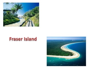
2. Fraser Island is a heritage-listed island located along the
southern coast of Queensland, Australia, approximately 200
kilometres (120 mi) north of Brisbane. It is a locality within
the Fraser Coast Region.Its length is about 120 kilometres
(75 mi) and its width is approximately 24 kilometres
(15 mi). It was inscribed as a World Heritage site in
1992.[ The island is considered to be the largest sand
island in the world at 1840 km2.[ It is also Queensland's
largest island, Australia's sixth largest island and the largest
island on the East Coast of Australia.
3. The island has rainforests, eucalyptus
woodland, mangrove forests, wallum and peat
swamps, sand dunes and coastal heaths. It is
made up of sand that has been accumulating
for approximately 750,000 years on volcanic
bedrock that provides a natural catchment for
the sediment which is carried on a strong
offshore current northwards along the coast.
Unlike on many sand dunes, plant life is
abundant due to the naturally
occurring mycorrhizal fungi present in the
sand, which release nutrients in a form that
can be absorbed by the plants.Fraser Island is
home to a small number of mammal species,as
well as a diverse range of birds, reptiles and
amphibians, including the occasional saltwater
crocodile. The island is part of the Fraser Coast
Region and protected in the Great Sandy
National Park.
4. Fraser Island is separated from the mainland by Great Sandy
Strait. The southern tip, near Tin Can Bay, is situated to the
north of Inskip Peninsula. The most northern point of the island
is Sandy Cape where the Sandy Cape Light operated from 1870
to 1994. The establishment of the lighthouse was the first
permanent European settlement on the island. The nearest
large town to Fraser Island is Hervey Bay,
whileMaryborough and Bundaberg are also close by. The bay
on the north east coast is called Marloo Bay and on the north
west coast is Platypus Bay. The most westerly place on the
island is Moon Point.
5. Eli Creek is the largest creek on the east coast
of the island with a flow of 80 million litres per
day. Eli Creek has its own unique and varied
wild life. Coongul Creek on the west coast has
a flow rate of four to five million litres per
hour.[Some of the swamps on the island
are fens, particularly near Moon Point. This
was only discovered in 1996 when a group of
experts who had attended
a Ramsar conference in Brisbane flew over the
island and conducted an aerial survey.
6. The total volume of sand above sea level on
Fraser Island is directly proportional to the
mass of 113 cubic kilometres (27 cubic
miles).All of the sand, which originated in
the Hawkesbury Hunter and Clarence River
catchments in New South Wales has been
transported north bylongshore
transport. Along the eastern coast of the island
the process is removing more sand than it is
depositing, resulting in the slow erosion of
beaches which may accelerate with sea level
rises attributed to climate change.
7. All hills on the island have been formed by
sandblowing. Sandblows are parabolic dunes
which move across the island via the wind and
are devoid of vegetation. In 2004, there was an
estimated total of 36 sandblows on the
island.]With year-round south-easterly wind,
the sand dunes on the island move at the rate
of 1 to 2 metres a year and grow to a height of
244 metres. The dune movement creates
overlapping dunes and sometimes intersects
waterways and covers forests. Dune-building
has occurred in episodes as the sea levels have
changed and once extended much further to
the east. The oldest dune system has been
dated at 700,000 years, which is the world's
oldest recorded sequence
8. The coloured sands found at Rainbow Gorge,
The Cathedrals, The Pinnacles and Red Canyon
are examples of where the sand has been
stained over thousands of years due to the
sand conglomerating with clay Hematite, the
mineral pigment responsible for the staining
acts like cement. This allows the steeper cliffs
of coloured sand to form. Coffee rock, so-
called because when it is dissolved in water it
turns the colour of coffee, is found in outcrops
along the beaches on both sides of the island.
9. Fraser Island has over 100 freshwater lakes,as well as the second
highest concentration of lakes in Australia after Tasmania. The
freshwater lakes on Fraser Island are some of the cleanest lakes in the
world.A popular tourist area is Lake McKenzie which is located inland
from the small town of Eurong. It is a perched lake sitting on top of
compact sand and vegetable matter 100 metres (330 ft) above sea
level. Lake McKenzie has an area of 150 hectares and is just over 5
metres (16 ft) in depth. The beach sand of Lake McKenzie is nearly
pure silica. The lakes have very few nutrients and ph varies,
though sunscreen and soaps bare a problem as a form of pollution.
10. Freshwater on the island may become stained
by organic acids found in decaying vegetation.
Because of the organic acids a pH level of 3.7
has been measured in some of the island's
perched lakes. The high acidity levels prevent
many species from finding habitat in the lakes.
11. Another perched lake on the island is Lake
Boomanjin, which at 200 hectares in size, is the
largest perched lake in the world.[ In total
there are 40 perched lakes on the island, half
of all known lakes of this kind on the
planet. Lake Boomanjin is fed by two creeks
that pass through a wallum swamp where
it collects tannins which tint the water
red. Lake Wabby is the deepest lake on the
island, at 12 metres (39 ft) in depth and also
the least acidic which means it has the most
aquatic life of all the lakes.
12. Fraser Islands climate is generally mild and is not subject to
extremes in temperature due to the moderating influence of the
ocean. Temperatures rarely rise above 35 °C or drop below 5 °C
and humidity is consistently high. Rainfall is heaviest during the
summer and early autumn, and the annual average is 1271mm
(50.04 in). Cyclones can be a threat, Cyclone Hamish brushed
the island as a category 5 in March 2009, while Cyclone
Oswald in January 2013 was significantly weaker at a Category 1.
Both storms however caused severe beach erosion, particularly
on the islands northern tip
13. Mammals
Estimates of the number of mammal species
present on the island range from 25 to
50.[Mammals found on Fraser Island
include swamp
wallabies, echidnas, ringtail andbrushtail
possums, sugar gliders, squirrel
gliders, phascogales, bandicoots, potoroos, flyi
ng foxes and dingoes. The swamp wallaby finds
protection from dingos in the swampy areas
which have dense undergrowth.There are 19
species of bats which live on or visit Fraser
Island.
Until 2003, when they were removed by the
Environmental Protection Agency,[there were a
few brumbies (horses) on the island,
descendants of Arab stock turned loose for
breeding purposes, and joined in 1879 by
horses brought over for the logging industry
14. here has been a total of 74 different species of
reptiles recorded on Fraser Island.18 species of
snakes have been identified with one third of
them considered dangerous, including the
extremely venomous eastern brown
snake. Goannas, snakes geckos skinks and fro
gs are all present on the island. Some frog
species have evolved to cope with the acidic
waters of lakes and swamps on the island, and
are appropriately called acid frogs.[ The island
is home to the recently discovered Fraser
Island sand skink. Freshwater turtles such
as Kreffts river turtle are found in the island's
lakes and creeks.
15. Saltwater crocodiles are exclusively tropical reptiles and usually found in Far
North Queensland (several hundred kilometres north-west of Fraser Island,)
however, occasionally during the warmer season (December through March,
when water temperatures reach consistent tropical temperatures) crocodiles
may appear in areas in and around Fraser Island. During the 2008–2009
summer several crocodiles (one over 4 metres in length) were present in the
surrounding ocean.[ It is thought that these reptiles are seasonal visitors, as
they always disappear during the cold months (presumably returning to
tropical northern Queensland.)
16. Fraser Island is part of the local government
area Fraser Coast Region, which was created in
March 2008 as a result of the report of the
Local Government Reform Commission
released in July 2007. Before the local
government reorganisation, the island was
split up evenly between the City of Hervey
Bay (northern part) and the City of
Maryborough (southern part)
17. In 1971, the northern half of the island was declared a national
park.Now almost all of Fraser Island is included in the Great Sandy
National Park, which is administered by Queensland's Environmental
Protection Agency. This was extended in 1992 when heritage listing was
granted. Except for a few small urban areas the island is protected by
a Wild Rivers declaration.
18. The name Fraser Island comes from Eliza
Fraser and her story of survival from a
shipwreck on the island. Captain James Fraser
and his wife, Eliza Fraser, were shipwrecked on
the island in 1836. Their ship, theStirling
Castle, set sail from Sydney to Singapore with
18 crew and passengers. The ship was holed
on coral while travelling through the Great
Barrier Reef north of the island
19. Archaeological research and evidence shows that Aboriginal
Australians occupied Fraser Island at least 5000 years ago. There was
a permanent population of 400–600 that grew to 2000–3000 in the
winter months due to abundant seafood resources. The arrival of
European settlers in the area was an overwhelming disaster for the
Badtjala people. European settlement in the 1840s overwhelmed the
Aboriginal lifestyle with weapons, disease and lack of food. By the
year 1890, Aboriginal numbers had been reduced to only 300 people
20. The geological wealth of the island lay in its rich deposits
of rutile, ilmenite, zircon and monazite. Sand mining leases
were first granted in 1950, and mining continued until
1977.[ Without public knowledge the Queensland Government
granted mining leases to the American mining company
Dillingham-Murphyores in the 1960s. In 1971, the Fraser Island
Defense Organisation (FIDO) opposed the granting of more
leases to the company. Despite more than 1,300 submissions
that were made to the local mining warden objecting to new
leases, the submission was granted.
https://www.youtube.com/watch?v=D0daSNw
SwXQ