C1.08A: The OceanSITES program of fixed open-ocean sustained timeseries - Uwe Send

Time series at critical or representative locations are an essential element of the global ocean observing system. They can provide a unique view of the full temporal behavior of a system; accurate reference and long-time baseline data; and the maximum possible range of interlinked variables from the seafloor to the atmosphere while enabling shared resources. The mission of the international OceanSITES program is to collect, deliver and promote the use of high-quality data from long-term, high-frequency observations at fixed locations in the open ocean. OceanSITES typically aim to collect multidisciplinary data worldwide from the full-depth water column as well as the overlying atmosphere. The presentation will cover the status, benefits, and structure of OceanSITES, some prominent examples of long fixed timeseries in the system, and plans for the future including the OceanSITES contribution to the Deep Ocean Observing System. Some emphasis will also be placed on the data management system, delivering homogeneous data sets in a unified format from single data portals.

Recomendados
Recomendados
Mais conteúdo relacionado
Mais procurados
Mais procurados (13)
Destaque
Destaque (17)
Semelhante a C1.08A: The OceanSITES program of fixed open-ocean sustained timeseries - Uwe Send
Semelhante a C1.08A: The OceanSITES program of fixed open-ocean sustained timeseries - Uwe Send (20)
Mais de Blue Planet Symposium
Mais de Blue Planet Symposium (20)
Último
Último (20)
C1.08A: The OceanSITES program of fixed open-ocean sustained timeseries - Uwe Send
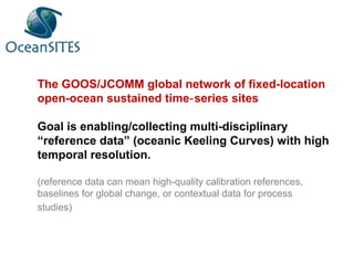
- 1. The GOOS/JCOMM global network of fixed-location open-ocean sustained time series sites‐ Goal is enabling/collecting multi-disciplinary “reference data” (oceanic Keeling Curves) with high temporal resolution. (reference data can mean high-quality calibration references, baselines for global change, or contextual data for process studies)
- 2. All sites are or aim to be: - sustained - serving multiple disciplines - open-ocean or relevant for the open ocean - freely sharing their data
- 3. The OceanSITES data system OceanSITES •has developed a time series data format based on international standards (netCDF files with CF metadata conventions) which can be used by anybody •has an active and experienced data management team •provides a data management system (regional DACs, GDACs, archive) with formatting support, to disseminate data •freely shares data publicly without delay •works with scientific user communities e.g. via GOOS, CLIVAR panels, and regional/thematic groups, to engage data users
- 4. New emphasis of community/user engagement via usage of the existing infrastructure, e.g. sharing of platforms (“moorings of opportunity”) and sensors •provide existing moorings for other PI’s or programs to add sensors •provide sensors to add to moorings of others in OceanSITES •use existing sites as RADs (researcher aggregating devices) •share operating costs and ship time, saving cost for all involved parties (example California Current: NOAA climate, NOAA OA program, NOAA fisheries) •can quickly and at low cost respond to emerging new needs (example Deep Ocean Observations) OceanSITES moorings can carry nearly any sensors desired.
- 5. Initial emphasis on deep T/S measurements Several types of contributions 1.Sites which already had deep T/S measurements 2.PIs willing to add deep T/S sensors to existing moorings to contribute to DOOS 3.OceanSITES pool of sensors exists which can be used to enhance additional existing moorings 4.Completely new sites which could be started using OceanSITES sensors: needs community mandate/ DOOS interaction 5.Can also add BGC sensors…. OceanSITES contribution to the DOOS (Deep Ocean Observing System):
- 6. OceanSITES visions for core biogeochemical and ecosystem observations at subset of sites Looking for enhanced interaction and collaboration with bgc and ecosystem communities
- 7. Join forces with BGC and ecosystem programs/communities Achieve high percentage of data submission Generate set of products and indices from the network Close gaps in the global coverage Make OceanSITES infrastructure widely used and attract programs, scientists, process studies to/around the sites. Develop routine users, especially for model validation and other reference data needs Forward Look
- 8. Please visit www.oceansites.org for list of benefits, Mission Statement, Governance, data manuals (data submission, data use, data format), etc. Thank you