Forest Hills Initiative Presentation Revised Version
•Transferir como PPT, PDF•
0 gostou•474 visualizações

The document summarizes a community planning process for the Forest Hills area of Boston. Over the course of 10 meetings between 2006 and 2008, hundreds of community residents provided feedback. This input was used to develop a community vision for the Forest Hills station area with goals of promoting residential and business growth while preserving open space. The vision included elements like a vibrant mixed-use district, improved traffic, community orientation, green and sustainable development, and enhanced green spaces.
![[object Object],[object Object],[object Object],[object Object],[object Object],The Road Ahead](data:image/gif;base64,R0lGODlhAQABAIAAAAAAAP///yH5BAEAAAAALAAAAAABAAEAAAIBRAA7)
Recomendados
Recomendados
Mais conteúdo relacionado
Mais procurados
Mais procurados (20)
Semelhante a Forest Hills Initiative Presentation Revised Version
Semelhante a Forest Hills Initiative Presentation Revised Version (20)
Forest Hills Initiative Presentation Revised Version
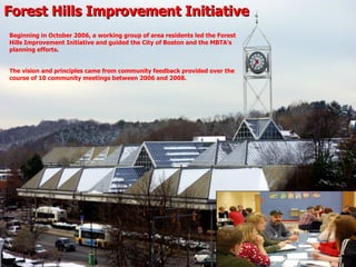
- 1. Forest Hills Improvement Initiative Beginning in October 2006, a working group of area residents led the Forest Hills Improvement Initiative and guided the City of Boston and the MBTA’s planning efforts. The vision and principles came from community feedback provided over the course of 10 community meetings between 2006 and 2008.
- 3. Consensus Participants in Forest Hills Task Force Community Organizations City Agencies: Office of Neighborhood Services Greater Forest Hills Area Task Force Massachusetts Bay Transportation Authority Boston Redevelopment Authority Boston Transportation Department Boston Parks and Recreation Department Department of Conservation and Recreation Community Residents Area Businesses
- 6. Guiding Principles Goals & Outcomes: A community vision for the Forest Hills station area that guides and promotes The best possible residential and business growth, and open space preservation .
- 8. Arborway Yards Not included in this presentation Fitzgerald Parking Lot MBTA Parcel S Parking Lot MBTA Parcel W MBTA Parcel V MBTA Parcel U Map of Study Area
- 9. Fitzgerald Parking Lot A mix of residential, retail, commercial and community space. Proposed Housing: 135 Units 2.31 Acres 100,477 Sq. Ft.
- 11. MBTA Parcel S (Parking Lot) A mix of commercial, office, institutional, retail, community uses, and commuter parking. 3.16 Acres 137,662 Sq. Ft.
- 13. MBTA Parcels U, V, & W
- 14. MBTA Parcel U Hyde Park Avenue & Ukraine Way A mix of residential, retail, and community uses. Proposed Housing: 120 Units 2.82 Acres 122,799 Sq. Ft.
- 16. MBTA Parcels V & W Information current as of February 1, 2010 Parcel W: WCI is in negotiations with a national grocer chain to possibly open up a store that will occupy approximately 8,000 – 10.000 square feet of space. Retail Uses WCI is actively exploring incorporating a number of green and sustainable building elements into the project. WCI has engaged the services of a traffic consultant who worked with the BRA during the community planning process. Additional Comments Provide space for local commercial businesses to support area community needs and as an anchor use for district. Commercial Uses Current plans by developer do not call for housing although this is subject to change. Residential Uses WCI Corp. has been designated developer. Filed project forms with BRA in December 2009. Disposition Status 22,975 SF / 0.53 Acres 58,541 SF / 1.34 Acres Parcel V Parcel W
- 17. MBTA Parcel W 1.34 Acres 58,541 SF
- 18. MBTA Parcel V 0.53 Acres 22,975 SF