Hydrogeology-of-the-Dry-Zone-Central-Myanmar PART-2

https://waterpartnership.org.au/hydrogeology-of-the-dry-zone-central-myanmar-published/ https://waterpartnership.org.au/publications/ https://waterpartnership.org.au/wp-content/uploads/2017/10/Hydrogeology-of-the-Dry-Zone-Central-Myanmar-Summary.pdf Hydrogeology of the Dry Zone, Central Myanmar Hydrogeology of the Dry Zone – Central Myanmar, is a major study by Dr Leonard Drury, prepared with assistance from the Ministry of Agriculture, Livestock and Irrigation (MOALI). The study revises and updates hydrogeological surveys and a drilling program begun in the late 1970s to mid-1980s. It represents an understanding of the groundwater resources of the Dry Zone based on decades of experience from hydrogeologists from Myanmar and Dr Drury’s extensive international experience (read full summary). Download Book: Hydrogeology of the Dry Zone, Central Myanmar 118mb Acknowledgements This report has been prepared by Dr Len Drury, Aqua Rock Konsultants, with assistance from the Groundwater Division, Irrigation and Water Utilization Management Department (IWUMD) of the Ministry of Agriculture, Livestock and Irrigation (MOALI). The figures and maps were digitised by International Centre Environmental Management (ICEM). The text was peer reviewed by the International Water Management Institute (IWMI). The author is grateful to colleagues (active and retired) from the Rural Water Supply Division (RWSD) of the Agricultural Mechanisation Department (AMD) and IWUMD, other government departments, universities, city and township development committees, Non-Government Organisations, and consulting companies who readily provided their hydrogeological reports and databases. Special thanks to Deputy Director General U Tin Maung Aye Htoo, Director U Htay Lwin, and Assistant Director U Than Zaw (IWUMD) whose professionalism and enthusiasm was outstanding; and U Myint Thein, Hydrogeological Advisor to the National Water Resources Committee (NWRC) – Advisory Group, who facilitated meetings and gave valuable input. Research Interests: Hydrogeology, Myanmar, Dry Zone, and central myanmar

Recomendados
Recomendados
Mais conteúdo relacionado
Mais de MYO AUNG Myanmar
Mais de MYO AUNG Myanmar (20)
Último
Último (17)
Hydrogeology-of-the-Dry-Zone-Central-Myanmar PART-2
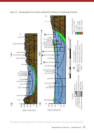
- 1. Hydrogeology of the Dry Zone — Central Myanmar 70 Figure 21 Hydrogeological Cross Section and Specific Conductance: Taungdwingyi Sub-basin L.Pleistocene toU.Miocene MiddleMiocene 200 300 ELEVATION(mAMSL) -100 100 200 300 ELEVATION(mAMSL) 6,000-10,000 3,000-6,000 1,500-3,000 <1,500 -1 510012.5515km LEGEND Quaternary Alluvium Recentsand IrrawaddyFormation PeguGroup ObogonFm. Artesianaquifer Directionofgroundwaterflow Potentiometricsurface IWUMDtubewellnumber(5465) 0 95⁰15'95⁰30' 95⁰30'95⁰15' A A' BB' Pokaingsan(5465) Popaukkan(3244) Yewai(3249) Gyokekone(2729) ThebyuChaung Samonywathit(2723) Wachangga(5453) Hingayaw(0764) BASINAXIS Mahtisanpya(6186) Kungyansu(6189) Shweoh(3122) TAUNGDWINGYITWS Sipinthaya(3038) YeU(5507) Palanbin(3901) Twingyi(6154) Yeyo(5318) Thityagaing(6157) BASINAXIS Myo-Oo(5310) NATMAUK AungSan(5312) YinChaung Wunbe-in(0867) MountPopaAnticline Kalashin(0865) Kabaungkongyi(1046) Lebu(1074) SpecificConductance (µScmat25⁰C) NandwinTawya Monastery ArtesianArea ShweHmawTaw Pagoda 250-270mDeeptoBlueGreyAquifer Hydrogeologicaldivide Gwegyo 400 Taungbyin ?? IrrigationOffice -100 -200 100 0 ? Yellowaquifer Bluegreyaquifer NOTE: Regional cross sections give general trends only. Thickness of Irrawaddy Formation unknown. At specific sites variations in detail will occur
- 2. 71 Hydrogeology of the Dry Zone — Central Myanmar Photo 24: Exit of Yin Chaung from Sub-basin – Dry Season 2017 Historically the Pegu Group rocks of the Bago Yoma have been considered poor aquifers, in terms of both quality and quantity. Overall brackish to salty groundwater occurs in the synclinal structures which have low hydraulic characteristics. Groundwater is confined to joint and fracture systems within the various rock types. North and northeast of Natmauk tubewells have intersected groundwater in fractured, semi-confined aquifers. The depth to aquifer varies from 25 to 140 metres, being dependent on topography and fracture location. Potential tubewell yield usually varies from 0.1 to 3 L/sec. Thayetchin Village is located on the flank of an unnamed syncline. This tubewell has a potential groundwater yield of 5 L/sec from fractured rock intersected at 92 to 101 metres. Nearby, deeper tubewells have only encountered smaller water supplies. The potentiometric surface is generally 10 to 20 metres below the surface during the dry period with a seasonal water level fluctuation of up to six metres. The dominant chemical type of the Bago Yoma aquifers is Na+ :Clˉ. Sulphate rich water occurs in shallow aquifers along major anticlinal structures. Specific conductance ranges from 2,140 to 9,200 µS.cm-1 . Chemical analysis from a shallow tubewell in Kalashin Village, east of Natmauk indicates that the Na+ :Clˉ type groundwater is brackish (3,690 µS.cm-1 ), has high alkalinity (pH 10) and elevated sulphate content76 . Low yielding, confined aquifers are intersected in fractured shale and fine sandstone on the Yedwet Anticline at depths of 150 to 240 metres. The potentiometric surface is 120 to 180 metres, depending on topographic relief. The specific conductance of groundwater ranges from 3,000 to 7,000 µS.cm-1 , the dominant chemical constituents being Na+ :Clˉ and Ca2+ :SO4 2- . Low salinity groundwater supplies are available from shallow dugwells constructed in the weathered zones. They usually dry up or become saline during January to May. Groundwater movement from the Bago Yoma is west and southwest towards Yin Chaung. The Yedwet Anticline forms a hydraulic barrier boundary to the Sub-basin with groundwater movement west to the Ayeyarwady River. Recharge is by direct rainfall into the exposed weathered fracture systems. 8.3 Irrawaddy Formation Based on colour the Irrawaddy Formation can be divided into two geological units77 : • Upper horizon- yellow / brown clay and fine to coarse sand ͳͳ western area- 75 to 270 metres thick; and ͳͳ eastern area- less than 300 metres. 76 Tin Nyi Nyi Win (2013) 77 Tin Linn et. al. (1988) Photo 25: Low Flow DTW- Lat Pan Kwae Village. 2016
- 3. Hydrogeology of the Dry Zone — Central Myanmar 72 • Lower horizon- bluish sandy clay with minor medium to coarse sand ͳͳ western area – 270 to greater than 400 metres thick; and ͳͳ eastern area – below 300 metres. The deeper sediments are located along the synclinal basin axis south of Myothit- mainly beneath and west of Taungdwingyi Town. The Irrawaddy Formation consists of fluviatile, fine to medium quartzose and lithic (mainly feldspar and mica) sand, conglomerate, grit, clay and shale. Thick yellow and deep blue clay aquitards overlie the thin aquifers. The sand and clayey sand aquifers usually account for 10 to 20 percent of the lithological sequence. The aquifers are weakly consolidated with ferruginous, calcareous and argillaceous cement. Siliceous, calcareous and iron oxide concretions and fossil wood are abundant. In the Natmauk and Myothit townships there is no record on groundwater discharge, potentiometric behaviour, long term pump-out tests or hydraulic parameters. In Taungdwingyi Township some drawdown and discharge data and pump-out tests are available, thus transmissivity can be estimated. 8.3.1 Northern Areas North and northeast of Natmauk the semi-confined aquifers occur as a synclinal inlier within the Bago Anticlinorium. This area has partially been inundated by the Kandaw Dam. Aquifers are generally intersected within 160 metres (210 m AMSL) with yields invariably less than 5 L/sec. Depth to the potentiometric surface ranges from 12 to 50 metres, mainly being a function of surface topography. Brackish to saline groundwater is Na+ :Clˉ type. On the alluvial flats, the Gwegyo Village tubewell intersected brackish water (2,650 µS.cm-1 ) with high hardness (860 mg/L) and elevated calcium (574 mg/L) content. In the elevated flanks of the Yedwet Anticline, the depth to aquifer is consistently 140 to 200 metres with the potentiometric surface at 75 to 120 metres. Most yields of the Na+ :HCO3 ˉ type, low salinity groundwater are below 5 L/sec. At Gwechaung Village the tubewell has a potential groundwater yield of 10 L/sec. The chemical type and low salinity is a marked contrast to that in neighbouring Peguan aquifers. Natmauk Town Water Supply No reticulated municipal water supply. Source: Hundreds of small diameter private tubewells screened in both Alluvium ( 20 metres) and Irrawaddy Formation aquifers. Groundwater yield varies from 0.5 to 5 L/sec. Town Water Demand: Assuming a population of 18,818 (Census 2014) and water consumption of 130 L/d/p, the town water supply demand is 2.5 ML/day. 8.3.2 Central to Southern Areas Between Taungdwingyi Town and Yin Chaung, tubewells intersect multiple yellow brown, semi-confined aquifers. Blue grey sands are encountered deeper at 270 metres, some exceeding 350 metres. At Kokkogwa Village the blue grey aquifer is 36 metres thick. Specific conductance of the Na+ :HCO3 ˉ water varies from 700 to 1,150 µS.cm-1 . Nandwin Tawya Monastery (Depth: 350 m): November 2016 Specific Conductance: 860 µS.cm-1 , Total Dissolved Salts: 610 mg/L, pH: 8.3, Temperature: 38.5o C.
- 4. 73 Hydrogeology of the Dry Zone — Central Myanmar A recent completed tubewell in Taungbyin (2) Ward, Taungdwingyi intersected clayey Alluvium to 75 metres then yellow/brown clay with minor silty sand lenses (124 to 132, 165 to 175 metres) (see Photo 26). The main lithology was clay and silt. Photo 26: Taungbyin (2) Ward, Taungdwingyi. Yellow/Brown Clayey/Silty Sand Aquifer (165-175 m), Nov 2016 Artesian conditions occur west of Taungdwingyi over synclinal axis. The eastern area partially overlaps the Alluvium artesian zone. Groundwater flow is small, the maximum discharge being 1.5 L/sec at Hingayaw Village. Initial artesian pressures have not been recorded. Due to continuous, uncontrolled flow groundwater discharge and pressure has reduced over time. For example, since 2005 the flow from the Lan Pan Kwae Village tubewell (230 metres) has decreased from 1 to 0.05 L/sec with increased salinity. The specific conductance of the Na+ :HCO3 ˉ type water is less than 1,500 µS.cm-1 . Groundwater from deep aquifers is quite warm (35o C). Lan Pan Kwae: November 2016 Specific Conductance: 1,150 µS.cm-1 , Total Dissolved Salts: 825 mg/L, pH: 8.6, Temperature: 39.30 C. Larger artesian flows may be encountered if appropriately designed and constructed tubewells are sunk into the deep blue grey aquifers in the centre of the synclinal trough. Maintenance of artesian pressure by regulating groundwater flow is an important water management issue that is currently absent. There is a general trend for brackish water (greater than 2,500 µS.cm-1 )to be in the yellow brown aquifers and better quality ( 1,000 µS.cm-1 ) closer to Yin Chaung and in the deep, blue sand aquifers. For example, a dugwell (30 metres) and the deeper tubewell (305 to 314 metres) at Kokkogwa Village have specific conductances of 6,700 and 700 µS.cm-1 respectively. A few pump-out tests have been carried out: • yellow/brown aquifer ͳͳ transmissivity (6 to 75 m2 /day); ͳͳ average hydraulic conductivity (2.5 m/day). • blue/grey silty fine to medium sand aquifer ͳͳ transmissivity (9 to 750 m2 /day); ͳͳ average hydraulic conductivity (21 m/day). Some of the aquifers west of Taungdwingyi have moderate transmissivity values but provide high potential tubewell yield due to their large available water level drawdown. Some clean sand and gravel aquifers have high transmissivity values (for example, 750 m2 /day at Inywagyi Village). These aquifers close to Yin Chaung offer a potential groundwater yield from large diameter tubewells greater than 50 L/sec.
- 5. Hydrogeology of the Dry Zone — Central Myanmar 74 Taungdwingyi Town Water Supply Operator: Taungdwingyi Township Development Committee. Source: Nine JICA constructed tubewells (eight constructed in 1980s and one in 2016) supply 2.4 ML/day. Depth ranges from 180 to 240 metres in yellow Irrawaddy Formation. JICA anticipates a yield of 0.9 ML/day from the new tubewell. Total TWS supply is thus 3.3 ML/day. The tubewells are located throughout the northern to central part of town, most close to Yadana Pwint Lake. JICA (2016) suggests aquifer recharge is from this surface water body. The slightly alkaline groundwater (pH 8.3 to 9.0) has TDS of 766 to 932 mg/L and hardness of 50 to 220 mg/L. Other: Within Taungdwingyi Town there are 1,100 private DTW supplying 2.3 ML/day. Town Water Demand: Assuming a population of 43,023 (Census 2014) and water consumption of 130 L/d/p, the town water supply demand is 5.6 ML/day. The current mix of government and private tubewells can achieve the town’s requirements. To the south of Taungdwingyi low salinity Na+:HCO3 ˉ type groundwater is intersected 100 to 230 metres below the surface. These aquifers have a transmissivity range of 10 to 100 m2 /day. At the villages of Kangyigon, Thetkegyin, Yedwinggaung and Nyaungbingwin the tubewells have a potential yield greater than 20 L/sec. Recharge to the aquifers is primarily by surface runoff from the Bago Yoma, direct infiltration of rainfall and surface water from the sandy chaungs during the Wet Season and permanent waterbodies (such as Yadana Pwint Lake). Under a moderately steep hydraulic gradient groundwater movement is towards the basin centre with discharge directed towards Yin Chaung, the overlying alluvial sediment in the central valley and locally to the flowing tubewells. Tritium analyses on five groundwater samples from the Irrawaddy Formation indicate that the water is pre-thermonuclear. Photo 27: Drill Site, Taungbyin (2) Ward, Taungdwingyi Town Photo 28: Taungdwingyi TWS Tubewell, Irrawaddy Formation
- 6. 75 Hydrogeology of the Dry Zone — Central Myanmar 8.4 Alluvium Due to the weathered nature and yellow colour of the shallow Irrawaddy Formation it is difficult to distinguish the contact zone with the overlying Recent Alluvium without palynological examination. An arbitrary depth of 75 metres is set as the boundary; this being based on similar depths in other nearby intermountain basins. The Alluvium consists of: • Younger Alluvium – three to 10 metres thick. Aquifers consist of sand, minor gravel; and • Older Alluvium – 75 metres thick. Aquifers consist of clayey sand and gravel. In the central valley between Natmauk and Myothit the aquifers are shallow (10 to 50 metres) and water table close to the surface. Tubewell yields are generally below 5 L/sec. However, several tubewells near Natmauk (Aung San Village) have potential groundwater yields more than 10 L/sec. The specific conductance of the Na+ :HCO3 ˉ type water is less than 1,000 µS.cm-1 . Shallow dugwells are constructed in unconsolidated sand beds close to Yin Chaung and associated tributaries to obtain reliable, low salinity domestic water supplies. The water table in the semi-unconfined aquifers varies from five to eight metres, with an annual fluctuation of 1.5 to five metres. High salinity groundwater is tapped by shallow dugwells away from the watercourses towards the Sub-basin boundaries. Deeper alluvial sediments are intersected by tubewells from Myothit to south of Taungdwingyi. Some permeable, unconsolidated sand aquifers, less than 60 metres deep are located along Ngamin, Seikpu and Yabe chaungs. Transmissivity ranges from 45 to 200 m2 /day. Potential yields of low salinity water near chaungs may exceed 10 L/sec (for example Tamarbin and Sarde villages). Some farmers use solar powered pumps to extract 6 L/sec from shallow alluvial sand aquifers for irrigation purposes. The specific conductance of deeper alluvial sediments ranges from 250 to 1,800 µS.cm-1 , the average being 1,000 µS.cm-1 . In most parts of the Taungdwingyi Town, potential groundwater yields are below 5 L/sec. Water from deeper alluvial aquifers is of lower salinity. For example, a dugwell and a tubewell in Alluvium under Shwebo Quarter, Taungdwingyi have specific conductance of 5,138 and 2,450 µS.cm-1 respectively. Na+ :Clˉ are the major ions in the dugwell and Na+ :HCO3 ˉ in the tubewell. Artesian flow from alluvial aquifers is encountered under Taungdwingyi at depths of 40 to 75 metres. Maximum natural groundwater discharge is 1.5 L/sec, the average being 0.7 L/sec. The specific conductance varies from 480 to 2,540 µS.cm-1 . The trend is for groundwater yield to decrease and salinity to increase towards the west. Groundwater recharge into the Alluvium occurs by infiltration from sandy and gravelly, intermittently flowing chaungs; directly from precipitation and from the underlying Irrawaddy Formation. Groundwater discharge from the Taungdwingyi Sub-basin only occurs as baseflow in Yin Chaung and westerly flowing throughflow in the underlying Alluvium and Irrawaddy Formation
- 7. Hydrogeology of the Dry Zone — Central Myanmar 76 8.5 Areas of High Groundwater Yield and Low Salinity Potential high yield and low salinity aquifers are concentrated along the synclinal axis of the Sub-basin (Figure 20). These include: • shallow Alluvium along the perennial Yin Chaung and intermittently flowing tributaries through spearpoint batteries or collector well systems; • lower sections of the yellow sand of the Irrawaddy Formation; and • the deep blue sand and gravel of the Irrawaddy Formation along the Sub-basin axis. Large diameter, deep, screened and gravel packed pumping bores would be required. 8.6 Water Balance Annual Recharge Estimation Future Research: A water balance model for the Taungdwingyi Sub-basin was developed but not successfully completed. The large rainfall recharge (assumed 10 to 15 percent) through the extensive exposure of Alluvium and Irrawaddy Formation could not be balanced with known groundwater extraction and end of Dry Season baseflow measurements. Groundwater needs to exit the sub-basin either through either discharge to Yin Chaung or underflow through the Alluvium and Irrawaddy Formation at the narrow western exit point.
- 8. 77 Hydrogeology of the Dry Zone — Central Myanmar 9 Hydrogeology of the Pakokku District 9.1 Introduction The Pakokku area is geologically complex. It is situated in the upper part of the Minbu Basin towards the 22o N Uplift. Regional structures include the Kabet-Shinmataung Anticline, Shinmataung Fault, Pakokku Syncline, Myaing and Letpanto anticlinal complexes, Medin Fault, Myaing-Kyaukpadaung and Bahin-Pagan structural lines, Yenangyat Anticline and Yenangyat Thrust Fault. The axis of the Salin Syncline is to the west of the features shown on Figures 22 to Figure 24. The Eocene to Mid Miocene rocks of Myaing, Letpanto and Yenangyat are highly fractured. They appear as tight, ripple-like, elongated, symmetrical folds segmented by transverse faults. Major gas and oil fields occur in the Yenangyat and Letpanto areas. The easterly dipping rocks of the Shinmataung Range also are highly faulted. A few geological or hydrogeological reports have been written specifically on the Pakokku area78 . Typical aquifer details in various rocks and geographical locations are given in Table 26. 9.2 Eocene Rocks The Eocene rocks crop out along the Myaing and Letpanto anticlinal complexes and along part of the Shinmataung Range. They consist of massive fossiliferous sandstone and marine bluish/black shale of the Pondaung and Yaw formations. Successful village water supply tubewells, intersecting semi-confined aquifers are located north of Letpanto to Myaing. These are located on both highly elevated plateaus and near the base of the escarpment slope. The depths to aquifers range from 41 to 93 metres, the higher elevated tubewells generally, although not consistently, being the deepest. On the hills, the depth to aquifer varies from 284 to 256 m AMSL, whilst along the escarpment base it ranges from 222 to 207 m AMSL. The depth of the potentiometric surface reflects the topographic elevation of the intersected aquifer. In the Letpanto area the water level varies between 310 to 293 m AMSL. The main direction of groundwater movement is north and northeast from recharge in the elevated plateau to discharge under the alluvial plain. Many abandoned tubewells also exist in the same area. Transmissivity is low ranging from 3 to 30 m2 /day. Only a few of the deeper aquifers at Gokekon and Tanaunggon villages have a potential tubewell yield of 6 L/sec. Most tubewells yield less than 1 L/sec. The tubewells on the plateau are in a hydrocarbon rich area. At Sinzwe, Gokekon and Tanaunggon villages the presence of methane gas is reported. High salinity occurs in some aquifers. For example, the specific conductance at Thinma and Nyaunggon villages is 8,000 and 12,530 µS.cm-1 . The main dissolved ions are 78 United Nations (1978), Tin Shwe et. al. (1979), Tahal (Water Planning) Ltd (1963), UNICEF (1980), Aung Myint (1983), Wan Maung et. al. (1984), Aung Myint et. al. (1986), JICA (1985), Ko Ko Gyi (2012)
- 9. Hydrogeology of the Dry Zone — Central Myanmar 78 Photo 29: Pauk Khaung Village TW, Lepanto, Eocene Aquifer Na+ :Clˉ and Na+ :SO4 2 . The high salinity is probably due to the presence of brine associated with oil/ gas accumulation and large deposits of gypsum observed along fractures within the anticlinal cores. Salinity decreases away from the structurally complex hydrocarbon areas as the fractured aquifers are recharged from rainfall and surface water runoff. In marked contrast, lower salinity groundwater (740 to 2,000 µS.cm-1 ) occurs in fractured Pondaung Sandstone lenses at Pauk Khaung and Wedaung villages respectively. In both cases upgradient intermittent watercourses traverse the Pondaung Sandstone outcrop which dips towards the villages. Other areas of low salinity within this overall saline environment may occur. In siting such tubewells consideration of geological structure, rock type, surface drainage systems and depth need to be considered. Pauk Khaung Village: May 2017, Depth: 101- 114, 155 – 165 m Specific Conductance: 740 µS.cm-1 , Total Dissolved Salts: 480 mg/L, pH: 8.3. Eocene rocks are intersected along the Medin Fault at a depth less than 200 metres. Transmissivities up to 85 m2 /day are recorded with a potential groundwater yield of 8 L/sec. This is the highest recorded Eocene transmissivity in the Pakokku area and reflects the good groundwater yielding potential of fractured aquifer systems associated with major fault zones. The average groundwater salinity is 3,400 µS.cm-1 . There is no tubewell data available in the Eocene rocks along the mid-western periphery of the Shinmataung Range. 9.3 Pegu Group The Oligocene age Shwezetaw, Padaung and Okhmintaung formations are exposed in the Letpanto to Myaing area whilst the upper two formations crop out along the Yenangyat Anticline and Shinmataung Range. North of Yesagyo, the Oligocene age Pegu Group is superficially covered by Alluvium. The complete sequence of Lower to Middle Miocene rocks is exposed along the anticlinal flanks of the Yenangyat Anticline and south of Letpanto. Aquifers in Pegu Group rocks of the easterly dipping Shinmataung Range usually provide high salinity and low yields. The specific conductance of the predominantly Na+ :Clˉ type water ranges from 1,100 to 10,100 µS.cm-1 , the average being 6,000 µS.cm-1 . The areal spread of salinity is erratic and appears confined to disjointed faulted blocks. The lowest salinity at A Nyar Taw Village (1,100 µS.cm-1 ) is sited in a fault adjacent to an intermittent watercourse. Within the village old tubewells away from the fault have salinities up to 8,400 µS.cm-1 . Consideration of structural geology is critical to siting successful tubewells in the Pegu Group rocks. Photo 30: Pondaung Sandstone Dipping South and Chaung
- 10. 79 Hydrogeology of the Dry Zone — Central Myanmar Figure22 SchematicGeologicalandHydrogeologyMap:Pakokku M ya i ngChaung 95°15'E95°E94°45'E 21°45'N 21°45'N 21°30'N 21°30'N G G G G G G GG
- 11. Hydrogeology of the Dry Zone — Central Myanmar 80 95°15'E95°E94°45'E 21°15'N 21°15'N 21°N 21°N G G Quaternary U.Miocene L.toM.Miocene Oligocene Eocene L.Pleistoceneto Alluvium Recentriversand IrrawaddyFormation PeguGroup Directionofgroundwater E EGeologicalcrosssection Synclinewithplungedirection Anticlinewithplungedirection E *Successfultubewells-Alluvium !(Successfultubewells-IrrawaddyFm. LEGEND F E M E PliocenetoUpperMiocene Alternatingsandstoneandshaleformations Extrusiveigneousrocks #Spotelevation(mAMSL) !(Successfultubewells-PeguGroup Methanegasinhole!( Tritiumanalysis!( Successfultubewell-Eocene/ ArtesiantubewellÓHydrogeologicalboundary (5454)IWUMDtubewellNo. [ 06123 Kilometres Drillingmudcirculationloss
- 12. 81 Hydrogeology of the Dry Zone — Central Myanmar Figure23 SchematicHydrogeologicalandHydrochemicalMap:Pakokku ^_ ^_^_^_^_^_^_ ^_ M ya i ngChaung 95°10'E95°E94°50'E94°40'E 21°50'N 21°50'N 21°40'N 21°40'N 21°30'N 21°30'N G G G G GG G G G
- 13. Hydrogeology of the Dry Zone — Central Myanmar 82 95°10'E95°E94°50'E94°40'E 21°20'N 21°20'N 21°10'N 21°10'N 21°N 21°N G Quaternary U.Miocene L.toM.Miocene Oligocene Eocene L.Pleistoceneto Alluvium Recentriversand IrrawaddyFormation PeguGroup *Successfultubewells-Alluvium !(Successfultubewells-IrrawaddyFm. LEGEND PliocenetoUpperMiocene Alternatingsandstoneandshaleformations Extrusiveigneousrocks #Spotelevation(mAMSL) !(Successfultubewells-PeguGroup Successfultubewell-Eocene/ ArtesiantubewellÓ [ Potentialhighyield(6L/sec) /lowsalinity(1,500µS.cm-1 Specificconductance(µS.cm-1 )630 ^_Arsenic50µg/L Specificconductance (µS.cm-1 at25°C) 1,500 1,500-3,000 3,000-6,000 6,000-10,000 10,000 3,000nearsurface,10,000atdepth 10,000nearsurface,1,500atdepth 06123 Kilometres NOTE:RegionalHydrogeologicalandHydrochemicalmapgivesgeneraltrendsonly.Atspecificsitesvariationsindetailwilloccur
- 14. 83 Hydrogeology of the Dry Zone — Central Myanmar Figure 24 Hydrogeological Cross Section and Specific Conductance: Pakokku A' Htanaungwin(0730) BanonChaung Konzin(1064) Kyauksaukma(0623) Kanzwe(2224) Nipasaydaw(4158) ShinmataungFault Kokkozu(4157) Tegyi(N)(2243) Danbingan(0535) Peikthingat(0701) Auko(3800) ChindwinRiver 95⁰00' NorthtoNgaKonYamaChaungGroundwatermovementNEtoChindwinRiver A 300 400 500 -100 0 100 ELEVATION(mAMSL) 200 Letpanto (1098) Wedaung (4184) Magyigon(4183) Gokekon(4201) Nyaunggon(3379) MyaingAnticline MedinFault Myaukse(3498) 94⁰45' GroundwatermovementnorthnorthwesttoNyaKonYamaChaung ELEVATION(mAMSL) B' Kyingan(1672) PaukU(3210) ChindwinRiver GroundwatermovementeasttoChindwinRiver -100 0 100 200 300 400 B LowerIrrawaddy UpperIrrawaddy WaterLevel Upper Irrawaddy YebyaChaung ChongaukChaung Kyauklon(3488) Ywathit(5412) Sebingyi(3583) Sebya(3493) BahinPagan StructuralLine Na-inChaung Daungo(0636) MyaingAnticline Sobyin(5413) MyaingKyaukpadaung TangedawChaung StructuralLine Chaungudo(3366) Tawwaygan(0693) Kyauksauk(3495) TangedawChaung YindaikpinChaung ShinmataungFault PakokkuSyncline YindaikpinChaung Obyun(3356) ShinmataungRange Daungogyi(1074) Yagyigon(1668) Theingon(1667) 95⁰ Chinyagon(4154) Hmaikbingone(5756) Myinthlachaung(4153) 00'45'94⁰ Groundwatermovementsouthwards PerchedAquifer Groundwatermovementsouthwards ??? PerchedAquifer NOTE: Regional cross sections give general trends only. Thickness of Irrawaddy Formation unknown. At specific sites variations in detail will occur
- 15. Hydrogeology of the Dry Zone — Central Myanmar 84 Figure 24 (continued) Hydrogeological Cross Section and Specific Conductance: Pakokku ELEVATION(mAMSL) IWUMDtubewellnumber(I234) -100 100 300 0 200 400 Directionofgroundwaterflow Fault Oligocene Potentionmetricsurface Obogon,Kyaukkok,Pyawbwe, Okhmintaung,Padaung,Shwezetaw LowertoMiddleMiocene Quaternary PeguGroup{ Alluvium Extrusiveigneousrocks 1005115km52.5 C' -1 C YawChaung Yebya(2317) Myingyangone(5754) Nyamolay(3615) Nyaungpintha(2443) HnawbaukChaung Natuyin(4192) YenangyatFault Thanbo(3568) Magyithonbin(3569) AyadawChaung Gyobyan(0651) Kanma Letpya(3570) Paunggwe(5719) ChaungmagyiChaung Kanthit(3489) Thitbingyi(5016) Kinywa(1058) Magyikoebin(1056) PakokkuSyncline ShwekyaungChaung Myauklugan(0506) Pongan(3571) ShinmataungFault Kyiywa(1062) Kyiywa(2013) Kabet-ShinmataungAnticline Paunglaungkan(1099) Magyibinpu(4165) Singyo(2237) Nathnyun(4826) AyeyarwadyRiver MovementtoYawChaungGroundwatermovementsouthwardstoAyeyarwadyRiverGroundwatermovementeast toAyeyarwadyRiverTheOasis 94⁰45'95⁰00' EoceneAlternatingsandstoneandshaleformations PliocenetoUpperMiocene L.PleistocenetoU.Miocene IrrawaddyFormation Claylens 6,000-10,000 3,000-6,000 1,500-3,000 1,500 10,000 SpecificConductance (µScmat25⁰C)Hydrogeologicaldivide Oilandgasfield(atdepth) Known-projecteddepthtoaquifer Leya-LayOld New( KanmaHospital LEGEND NOTE: Regional cross sections give general trends only. Thickness of Irrawaddy Formation unknown. At specific sites variations in detail will occur
- 16. 85 Hydrogeology of the Dry Zone — Central Myanmar Table26 AquiferDetailsfromVariousRockTypesinthePakokkuArea79 FormationAreaVillageTubewell number Surface Elevation (mAMSL) Alldatafromsurface(m)DD (m) Airlift Yield (L/sec) Transmissivity (m2 /d) Specific Conductivity (µS.cm-1 ) DepthAquiferSWLDDL Eocene LetpantoPaukKhaung180100-115 155-165 90100100.1174079 Pegu/Irrawaddy Shinmataung Anticline Kyiywa HtanNgeTaw 1062+86 +90 92 146 83-91 27-37 32 22 3647 3 24613,000 6,940 Irrawaddy Formation MyitcheHorsebreeding MyitChay AingGyi 3370+61 +60 +58 58 43 40 17-55 38-41 35-38 12 9 5 15 13 12 3 4 7 13 7 9 514 240 180 520 Chaungmagyi Chaung ZigonWest4176+10210482-101444846179660 PaleSub-basinDamathaya (seeCh.10) 3478+138202174-195243179179900 Pakokku Syncline Kangyigon Kontatkon GTCstation IndustrialZone 3362 4167 +128 +122 +135 +120 95 128 91 79 62-92 101-125 55-61 64-70 13 56 26 23 16 59 29 3 3 6 13 5 8 513 206 200 480 720 680 820 Bahin-PaganShainggaung TaNaung 5415+205 +210 198 50 177-186 38-41 122 19 129761071,500 1,200 HighPlateauSinsein5409+3057057-6620233105971,050 Shinmataung Range Thadaing HtanNgeTaw 0746+76 +90 36 146 32-35 28-36 8 22 11362392,500 6,940 W.Fault Shinmataung TaungOo Kyauksauk +145 +150 13575-90 101-110 60-66 91-105 20 18202 5 3200 640 1,200 Alluvium SouthPakokkuLeya Mongon 3575 3603 +73 +61 62 47 41-57 29-37 9 9 14 11 5 2 6 3 172 206 1,250 700 NorthPakokkuMagyibinpu Inma 4165 1605 +61 +55 52 31 39-46 21-27 4 8 8 1 4 1 8 4 258 770 510 300 YawChaungSanyaun4327+1734024-346714606540 Source:IWUMDdatabase. 79 IntermittentchaungrechargeintoPondaungSandstone
- 17. Hydrogeology of the Dry Zone — Central Myanmar 86 A Nyar Taw Village: May 2017, Depth: 107- 116, 122 – 128 m Specific Conductance: 1,100 µS.cm-1 , Total Dissolved Salts: 720 mg/L, pH: 7.4. The general trend is for salinity to increase with depth, but this is not always the case. The depth to aquifers is highly variable ranging from 24 to 214 metres. The potentiometric surface is located 7 to 28 metres below the surface in conformity with the topography. Some aquifers appear to be interconnected whilst others are likely to be isolated between fault blocks. Tritium analysis of groundwater from an aquifer at Satthwa Village indicates pre-thermonuclear water. The aquifers above 45 metres are clayey and yield below 5 L/sec; the majority less than 0.5 L/sec. Once the unweathered fracture zone is intersected the potential yield may exceed 10 L/sec. Transmissivity in the deeper aquifers ranges from 15 to 65 m2 /day, the average being about 35 m2 /day. Groundwater recharge occurs by rainfall onto the exposed fracture systems along the Shinmataung Range. Groundwater movement is east towards the Chindwin River and southeast towards the Ayeyarwady River. Immediately south of the Shinmataung Range and east of the Shinmataung Fault and Kabet-Shinmataung Anticline, aquifers in fractured Pegu Group rocks are intersected beneath a thin cover of Irrawaddy Formation. Here multiple aquifer systems are encountered between 17 to 140 metres. The potentiometric surface in the shallow aquifer is 5 to 30 metres whilst the water levels in the deeper zones range between 34 to 69 metres. These aquifers have poor hydraulic interconnection. The fractured, semi-confined to confined aquifers contain weathered zones and yields are less than 5 L/sec. Transmissivity ranges from four to 30 m2 /day. The salinity of the Na+: Clˉ type groundwater ranges from 5,000 µS.cm-1 in the shallow aquifers to more than 10,000 µS.cm-1 at depth. West of the Shinmataung Fault the Pegu Group rocks are down-faulted and not encountered for at least 180 metres. Northeast of the Shinmataung Range several tubewells intersect aquifers of the Pegu Group after passing through a superficial alluvial or Irrawaddy Formation cover. The depth to the fractured aquifer system is highly variable (17 to 100 metres) with tubewell yield below 5 L/sec. Transmissivity ranges from 10 to 30 m2 /day and the specific conductance from 1,300 to 5,700 µS.cm-1 . Peguan aquifers are also intersected within the Letpanto oilfield at depths of 86 to 107 metres. Methane gas is frequently reported. The potentiometric surface in these low yielding aquifers slopes sharply to the south. The salinity of the Na+ :Clˉ and Na+ :SO4 2- type groundwater at Kyauktagin Village exceeds 10,000 µS.cm-1 . The salinity and chemical characteristics of this water possibly result from a mixture of brine water (in association with the hydrocarbons) and the high solubility of the abundant gypsum deposits located within the fracture systems. No successful groundwater tubewell is documented along the Yenangyat Anticline. 9.4 Irrawaddy Formation Rocks of the Irrawaddy Formation consist of fine to medium-grained, poorly argillaceous cemented sand, conglomerate, gravel, shale, clay, fossil wood and lignite. These intermountain sediments are aligned along the orientation of the major regional features. In some areas, sediments of both the Upper and Lower Irrawaddy units can be identified. Both yellow brown and blue grey aquifers are present. Groundwater movement and yield is strongly controlled by the regional geological structures and lithology within which they are associated. The depth to aquifers closely conforms to the associated tectonic structural features. Once these major structures are identified, confident prediction on depth, quality and yield should be possible.
- 18. 87 Hydrogeology of the Dry Zone — Central Myanmar Shallow perched aquifers (Figure 24) are located: • south of Myaing along the upper catchment of Tangedaw Chaung; • between Yela-Ale to Gyobyan villages- locally known as ‘The Oasis’; and • southwest of Ywathit. The latter two are located within a broad synclinal area between the Bahin-Pagan Structural Line and the Yenangyat Anticline. Other small perched aquifer systems may be present. Most perched aquifers are of limited extent. They may be useful for shallow domestic water supplies, if the salinity is of acceptable quality. Figure 22 indicates the hydrogeological boundaries and direction of groundwater movement. The location of the subsurface groundwater divide separating the Pale Sub-basin from the Pakokku Syncline passes near Kangyigon and Alegan villages to the east of Myaing. 9.4.1 Pakokku Syncline Groundwater movement in aquifers within the Pakokku Syncline is mainly south towards the Ayeyarwady River; being bounded to the west by the Medin Fault and east by the Shinmataung Fault and the Kabet-Shinmataung Anticline. Due to the latter two tectonic structures, no groundwater movement occurs to the east towards the Ayeyarwady and Chindwin rivers. To the west of the Shinmataung Fault, yellow clay and sand occurs to 200 metres and then blue grey sands and clay to at least 400 metres. Aquifers occupy 20 to 25 percent of the sediment. Groundwater yields are usually 2 to 10 L/sec. The specific conductance of the Na+ :HCO3 ˉ water is usually less than 1,500 µS.cm-1 . There are a few exceptions in some shallow aquifers where salinity varies from 1,500 to 3,000 µS.cm-1 . Salinity increases around the flanks of the Pegu Group and Eocene rock outcrops. Groundwater recharge occurs along the sandy Tangedaw Chaung and associated watercourses. Movement is into either the highly permeable, perched aquifers or direct into the deeper aquifers of the Pakokku Syncline. Some artesian flowing tubewells occur in topographic depressions. Photo 31: Lithological Variation in Kyauksauk Village TW, Irrawaddy Formation (41-46, 55-60, 142-146 m), Pakokku Syncline Taung Oo Village presents an excellent interpretation of hydrogeological conditions in the Pakokku Syncline. Several saline tubewells are in the village on the western flank of the Shinmataung Range. The new tubewell was sited 1.5 kilometres west of the Shinmataung Fault and intersected high yield, low salinity groundwater at depths of 75 to 110 metres. The potable water is pumped via pipeline back to the village. Kyauksauk Artesian Tubewell: November 2016 Specific Conductance: 1,430 µS.cm-1 , Total Dissolved Salts: 1,037 mg/L, pH: 7.2.
- 19. Hydrogeology of the Dry Zone — Central Myanmar 88 Htanngetaw Village Artesian Tubewell: November 2016 Specific Conductance: 1,450 µS.cm-1 , Total Dissolved Salts: 1,039 mg/L, pH: 7.2, Temperature 28.8o C. Taung Oo Village: May 2017, Aquifer Depth: 75- 90, 101 – 110 metres Specific Conductance: 640 µS.cm-1 , Total Dissolved Salts: 322 mg/L, pH: 8.1. Pakokku Town Water Supply Operator: The Pakokku Township Development Committee. Source: 12 deep tubewells located throughout town. Depths: varying from 73 to 138 metres in Alluvium and Irrawaddy Formation. Groundwater Yield: 2.5 to 14 L/sec. pumping 2 to 15 hours/day. Total Yield Capacity: 5.4 ML/day. Potentiometric surface: 10 metres (alluvial flats) to 50 metres (on hills). Summary of Water Quality: pH: 6.5 to 6.94, Electrical Conductivity: 571- 1,865 µS.cm-1 , TDS 411- 1,320 mg/L. Other: Within Pakokku there are over 1,000 private DTW and hundreds of DW supplying 6.4 ML/day. Town Water Demand: For a population of 90,842 (Census 2014) the town water demand is 11.8 ML/day, supplied by municipal and private sources. Pakokku Town Water Supply: Su Gyi Pan Quarter: November 2016 Specific Conductance: 700 µS.cm-1 , Total Dissolved Salts: 501 mg/L, pH: 7.1, Temperature: 32.1o C. Photo 32: Myaing TWS Tubewell No. 2, Irrawaddy Fm. Photo 33: Collecting Water, New DTW, Taung Oo Village, Irrawaddy Fm.
- 20. 89 Hydrogeology of the Dry Zone — Central Myanmar Myaing Town Water Supply Operator: The Myaing Township Development Committee operates eight DTWs and has recently completed five new DTWs (not yet equipped). The water supply scheme was paid by municipal funds and parliamentary budget. Sources: When complete, the water supply system will consist of 13 DTWs screened in Irrawaddy Formation aquifers. The DTWs are in the eastern part of town away from the Eocene rocks. Groundwater yield and water levels are declining, thus the need for the additional DTWs along Myaing Chaung. The yield is also restricted by available electric power supply. Tubewell log (No. 2 Quarter) indicates a depth of 128 metres with screens at 66 to 70, 90 to 99, 108 to 114 metres. Depth: 125 to 150 metres. Groundwater Yield: 1 to 6 L/sec; average 2 L/sec. Each new production tubewells yields 4 L/sec. Current Wet Season Yield: 8 DTWs x 2 L/sec x 10 hours/day = 0.58 ML/day. Current Dry Season Yield: 8 DTWs x 2 L/sec x 24 hours/day = 1.4 ML/day (if power consistently available). Potentiometric surface: 20 to 27 metres. Groundwater salinity: varies from 1,146 to 1,881 µS.cm-1 . New DTW near Myaing Chaung is 513 to 627 µS.cm-1 . Town Water Demand: The water demand for a population of 7,706 (Census 2014) is around 1 ML/ day. Assuming a reliable electricity power supply and pumps installed in new holes the municipal water supply should achieve the town’s requirements. Myaing Town Water Supply, Tubewell No. 2 Quarter (in town): November 2016 Specific Conductance: 1,340 µS.cm-1 , Total Dissolved Salts: 975 mg/L, pH: 7.1, Temperature: 28.9o C. Myaing Town Water Supply, Tubewell No. 1 Quarter (in town): November 2016 Specific Conductance: 1,400 µS.cm-1 , Total Dissolved Salts: 1,000 mg/L, pH: 6.9, Temperature: 29.1o C. 9.4.2 Southwest of Shinmataung Range Near the southwestern extent of the Shinmataung Range several tubewells intersect highly saline aquifers. Salinity increases with depth. For example, at Kyiywa Village (TW Nos 2013 and 1062) aquifers were intersected with a specific conductance of 2,180 and 10,000 µS.cm-1 at depths of 40 to 47 metres and 85 to 90 metres respectively. A recently abandoned tubewell in Htan Nge Taw Village intersected brackish groundwater (6,940 µS.cm-1 ) at 25 metres. The dominant soluble ions change from Na+ :HCO3 ˉ in the shallow aquifers to Na+ :Clˉ with depth. A similar change in salinity occurs at Paunglaungkan Village where at depths of four to six, 27 to 31, and 76 to 79 metres, the specific conductance increases from 2,660, 4,360 to 12,500 µS.cm-1 respectively. The two shallow aquifers contain Na+ :HCO3 ˉ type water whereas the deeper groundwater is Na+ :Clˉ. Drilling for potable water in this area should be avoided. The increase in salinity with depth is assumed to be saline groundwater drainage from Peguan aquifers within the Shinmataung Range.
- 21. Hydrogeology of the Dry Zone — Central Myanmar 90 Htan Nge Taw Village: May 2017, Depth: 25 – 40 m Specific Conductance: 6,940 µS.cm-1 , Total Dissolved Salts: 4,510 mg/L, pH: 8.2. 9.4.3 Bahin-Pagan and Myaing-Kyaukpadaung Structural Lines In the broad trough between the Bahin-Pagan and Myaing-Kyaukpadaung structural lines groundwater movement is SSE to south from the elevated Letpanto and Myaing areas towards the Ayeyarwady River. Low salinity, Na+ :HCO3 ˉ type groundwater is usually intersected, except near Pegu Group rock outcrops. Along the road west from Pakokku the depth to the regional aquifer increases from 60 to 100 metres as surface topography rises. In the Oasis, the perched and regional aquifers have different aquifer depth, potentiometric surface, yield and salinity variations (Table 27). Table 27 Features of Perched and Regional Aquifers – The Oasis Area, Pakokku Village Depth Screen SWL Airlift Yield (L/sec) Specific Conductance (µS.cm-1 ) Status (m) Local Perched Irrawaddy Formation Aquifer Leya Lay (new) 76 70- 76 19 2 1,640 Operational Leya Lay (old) 61 50- 55 18 1 10,000 Abandoned Gyobyan 91 70- 79 19 3 1,840 Operational Regional Irrawaddy Formation Aquifer Kan Ma Hospital 132 119- 125 49 6 1,570 Operational Paunggwa 147 104- 110 61 4 770 Operational Magyithanbin 214 207- 213 61 6 680 Operational Source: IWUMD database. The abandoned Leya Lay Village tubewell intersected Na+ :Clˉ type water at a depth less than 55 metres with specific conductance more than 10,000 µS.cm-1 . The replacement tubewell, with the shallow aquifer sealed off, intersected better quality water (1,640 µS.cm-1 ) at greater depth. The Gyobyan Village tubewell intersected Na+ :HCO3 ˉ type water with a specific conductance of 1,840 µS.cm-1 . The reason for such a marked change in chemical character and salinity within the perched aquifer system has not been adequately investigated. Evapotranspiration and lithological variations may need to be considered. Throughout the Oasis area, tubewells deeper than 100 metres intersect the regional aquifer system with Na+ :HCO3 ˉ type water below 1,600 µS.cm-1 . During tubewell construction, the upper aquifers should be cement-sealed to prevent the movement of saline water into the tubewell. Groundwater recharge occurs along the sandy watercourses. Leya Lay (new): November 2016 Specific Conductance: 1,640 µS.cm-1 , Total Dissolved Salts: 1,198 mg/L, pH: 7.9, Temperature: 23.6o C. Kan Ma Hospital: November 2016 Specific Conductance: 1,570 µS.cm-1 , Total Dissolved Salts: 1,164 mg/L, pH:8.1, Temperature:23.6o C. To the west of the Yenangyat Anticline low salinity water in the Irrawaddy Formation moves towards Yaw Chaung.
- 22. 91 Hydrogeology of the Dry Zone — Central Myanmar The Irrawaddy Formation in the Letpanto area is located overlying hydrocarbon rich Eocene to Mid Miocene rocks. Methane gas is observed in Kanthit and Sinsein tubewells at depths of 110 to 134 metres and 57 to 66 metres respectively. 9.4.4 Loss of Mud Circulation Loss of drilling mud circulation during tubewell construction has been recorded in unsaturated yellow, coarse sediment. The problem areas are in the broad synclinal trough between the Bahin-Pagan and Myaing-Kyaukpadaung structural lines and a small part of the Pakokku Syncline. Depths to aquifer and potentiometric surface in most cases are greater than 150 and 90 metres respectively. 9.4.5 Tritium Dating Tritium analyses taken from nine tubewells indicate that most of the groundwater is pre-thermonuclear. The exception is at Paunglaunkgan Village (TW No 1099) where the shallow, saline water appears to be a mixture of both Modern and older groundwater. 9.5 Alluvium Alluvial deposits of Pleistocene to Recent age are located along the Ayeyarwady and Chindwin rivers, and Chaungmagyi, Nga Kon Yama and Yaw chaungs. These unconsolidated sediments consist of clay, silt, sand and gravel. Alluvial terraces consisting of gravel and sand are observed southwest of Pakokku near the village of Leya. A proliferation of private shallow and deep tubewells occurs along these alluvial flats and terraces. Southwest of Pakokku, tubewells intersect semi-unconfined, yellow brown sand and gravel aquifers at depths of 14 to 72 metres. The water level varies from five to 12 metres. Low salinity Na+ :HCO3 ˉ type groundwater is located within the shallow alluvial aquifers. With a transmissivity range of 50 to 420 m2 / day and specific conductance of 400 to 1,250 µS.cm-1 some aquifers are relatively permeable and high groundwater yields of low salinity water should be available. Recharge to the shallow aquifer is from the sandy tributaries that traverse the alluvial flats. Groundwater movement is towards the Ayeyarwady River. Groundwater levels adjacent to the Ayeyarwady River fluctuate with the river height80 due to direct hydraulic connection. During flood periods, a localised reversal in groundwater movement may occur. Tritium analyses of shallow groundwater at Aletaik and Aungtha villages, indicate a pre-thermonuclear age. These villages are two and four kilometres from the Ayeyarwady River and appear to be recharged upgradient from Shwekyaung and Chaungmagyi chaungs respectively. Northeast of Pakokku semi-unconfined gravel and sand aquifers are located near the Ayeyarwady River. The depth to aquifer varies from 12 to 52 metres and potential yield frequently exceeds 10 L/sec. Transmissivity ranges from 25 to 650 m2 /day. Low salinity Na+ :HCO3 ˉ water is available from shallow aquifers, especially close to the Ayeyarwady River where hydraulic interconnection is likely. Excessive groundwater withdrawals from the shallow aquifers close to Pegu Group rocks may induce salt water intrusion and result in a deterioration in water quality. Being along the flowpath of saline groundwater from the Shinmataung Range, deeper aquifers, if present may be unsuitable for irrigation or domestic purposes. 80 Local farmers pers. comm.
- 23. Hydrogeology of the Dry Zone — Central Myanmar 92 Near Yesagyo the aquifers consist of clean sand and gravel at depths of 15 to 40 metres. The water level varies from five to nine metres. Transmissivity values range from 60 to 200 m2 /day. The yield of low salinity groundwater may exceed 10 L/sec. Tritium results from Kudok Village indicate Modern water and thus is in a recharge zone. IWUMD reports that since commencement of the Wayathazi River Pumping Scheme groundwater salinity has reduced and water levels risen due to vertical leakage from overlying irrigation water. Table 17 indicates that from 522 dugwells and tubewells in Yesagyo Township arsenic exceeds the WHO and NDWQS standards of 10 and 50 µS.cm-1 by 18.4 and 1.3 percent respectively. Most were from the shallow Alluvium. In the Oasis area, the specific conductance of water from the shallow alluvial aquifers ranges from 4,500 to 15,000 µS.cm-1 . An irrigation tubewell at the horse breeding farm at Myitche is equipped with an electrosubmersible pump capable of yielding 10 L/sec. Groundwater salinity near Chaungmagyi Chaung is 400 µS.cm-1 . West of the Yenangyaung Anticline many dugwells and tubewells are sunk into unconfined to semi-confined, medium to coarse grained sand aquifers along Yaw Chaung. The depth to aquifer ranges from eight to 15 metres (shallow Alluvium) and 65 metres (older Alluvium). Transmissivity values range from 55 to 500 m2 /day. Water levels are from three to nine metres. The likely source of aquifer recharge is Yaw Chaung. Tritium dating at Myingyawgone Village indicates Modern water. The potential groundwater yield may exceed 20 L/sec, especially from the deeper aquifers. The specific conductance of this Na+ :HCO3 ˉ type groundwater is less than 1,000 µS.cm-1 . 9.6 Areas of High Groundwater Yield and Low Salinity Figure 23 shows that high yielding aquifers of low salinity water should be located: • around Myitche near the Ayeyarwady River (transmissivity up to 514 m2 /day); • along Chaungmagyi Chaung and the Bahin-Pagan Structural Line passing the Pakokku-Pauk Road before reaching The Oasis (transmissivity up to 179 m2 /day); • around Pakokku (transmissivity up to 513 m2 /day); • between Pakokku and Myaing overlying the Pakokku Syncline (transmissivity up to 107 m2 /day); • the Pale Sub-basin (see Chapter 10); • west of Yenangyat Anticline along Yaw Chaung (transmissivity up to 200 m2 /day); and • east of the Shinmataung Anticline and Shinmataung Range (transmissivity up to 250 m2 /day). Groundwater in the Irrawaddy Formation and Alluvium close to the Pegu Group or Eocene rocks may be unsuitable for irrigation due to their high salinity. The areas excluded are: • The Oasis as the potentiometric surface usually exceeds 60 metres and is overlain by brackish areas; and • the elevated area around Sinsein Village (transmissivity up to 600 m2 /day) due to the depth to aquifer and potentiometric surface and the upgradient high salinity groundwater of the Pegu Group. 9.7 Water Balance Annual Recharge Estimation Water balance for the ARC and estimates of groundwater in storage are given in Chapter 17.
- 24. 93 Hydrogeology of the Dry Zone — Central Myanmar 10 Hydrogeology of the Pale Sub-basin 10.1 Introduction The agricultural-based Pale Sub-basin is situated within Yinmabin and Salingyi townships, Sagaing Region. Yinmabin and Pale are the main administrative centres. Table 28 indicates geological equivalents to the stratigraphic column for the Pale Sub-basin. The nomenclature used here is based on the Standard Minbu Basin, the 2014 Geological Map (Myanmar Geosciences Society), IWUMD terminology and other references81 . Some geological and hydrogeology reports on the Pale Sub-basin have been prepared82 . The geology and hydrogeology are shown on Figure 25 to Figure 27. Examples of aquifer details are on Table 29. Table 28 Stratigraphic Column for Pale Sub-basin8384 STAGE (assumed)83 PALE SUB-BASIN84 PRESENT REPORT MINBU BASIN QUATERNARY Holocene Kangon Fm Unconsolidated Sediment Unconsolidated Sediment Pleistocene Upper Middle Lower Kokkogon Fm including Kokkogon Aquifer Ywatha/Aungban Aquifer Volcanics Maw Gravel TERTIARY Pliocene Magyigon Fm Upper Irrawaddy Fm Lower Irrawaddy Fm Miocene Upper Middle Lower Damapala Fm Obogon Kyaukkok Pyawbwe Obogon Kyaukkok Pyawbwe PeguGroup Oligocene Upper Middle Lower Okhmintaung Padaung Shwezetaw Okhmintaung Padaung Shwezetaw Eocene Upper Middle Lower Pondaung Wazein Taung Fm Yaw Pondaung Tabyin Tilin Laungshe Yaw Pondaung Tabyin Tilin Laungshe Palaeocene Upper Middle Lower Paunggyi Paunggyi Basement Complex Basement Complex Basement Complex Cretaceous 81 GDC (1983), Tin Win (2016) 82 Sein Myint et. al. (1970), Ahed (1979), Yin Swe et. al. (1979), Groundwater Development Consultants (1979, 1980a,b, 1981a-g, 1982a-c, 1983a,b, 1984a-c), Ko Ko et. al. (1980), Toe Yi (1980), Kyaw Aung (1984), Htet Wai Aung (2015), Myo Kyaw Tun (2015), Tin Win (2016), Aung Khaing Moe (2016), Hein Thu (2016) 83 geological age (million years) is not given as author does not recognise method of determination 84 Htet Wai Aung (2015), Myo Kyaw Tu (2015)
- 25. Hydrogeology of the Dry Zone — Central Myanmar 94 Figure 25 Schematic Geological and Hydrogeological Map: Pale Sub-basin 95°E 95°E 94°45'E 94°45'E 22°15'N 22°15'N 22°N 22°N 21°45'N 21°45'N Alternating sandstone and Quaternary U.Miocene L.Pleistocene to Alluvium recent river sand Irrawaddy Formation L E G E N D Oligocene Eocene U.Miocene L.Pleistocene to Extrusive igneous rocks Pegu Group Intrusive igneous rock Direction of groundwater E E Geological cross section E Test tubewell - Irr. Dept.A! Hydrogeological boundary # Spot elevation (m AMSL) !( Successful tubewells - Irrawaddy Fm. !( Successful tubewells - Pegu Group Successful tubewells - Eocene/ Tritium analysis!( 1/15 Irrigation Dept. tubewell number shale formation Syncline with plunge direction Anticline with plunge directionF E M E Potentiometric surface – Kokkogon Potentiometric surface – Y/B Aquifer #* Successful tubewells-Alluvium 99 Ponds G/W Irrigation Project C-14 dating C-14 dating C-14 dating C-14 dating ( Radiocarbon dating 0 6 123 Kilometres [ NOTE: Regional cross sections give general trends only. Thickness of Irrawaddy Formation unknown. At specific sites variations in detail will occur
- 26. 95 Hydrogeology of the Dry Zone — Central Myanmar Figure 26 Schematic Hydrogeological and Hydrochemical Map: Pale Sub-basin 95°0'E 95°0'E 94°45'E 94°45'E 22°15'N 22°15'N 22°0'N 22°0'N 21°45'N 21°45'N Alternating sandstone and Quaternary U.Miocene L.Pleistocene to Alluvium recent river sand Irrawaddy Formation L E G E N D Oligocene Eocene U.Miocene L.Pleistocene to Extrusive igneous rocks Pegu Group Intrusive igneous rock Test tubewell - Irr. Dept.A! !( Successful tubewells - Irrawaddy Fm. !( Successful tubewells - Pegu Group Successful tubewells - Eocene/shale formation #* Successful tubewells-Alluvium Potential high yield (6 L/sec) / low salinity (1,500 µS.cm-1 ) Specific conductance (µS.cm-1 at 25°C) 1,500 1,500 - 3,000 3,000 - 6,000 6,000 - 10,000 10,000 G G Specific conductance (µS.cm-1 )790 [ 0 6 123 Kilometres NOTE: Regional Hydrogeological and Hydrochemical map gives general trends only. At specific sites variations in detail will occur
- 27. Hydrogeology of the Dry Zone — Central Myanmar 96 Figure 27 Hydrogeological Cross Section and Specific Conductance: Pale Sub-basinArtesiantubewells KokkogonaquiferAA' 300 (0571) 200 1/14 Anticline PW1/1 EH1/3 Nweshauk Springs (3512) 1/22 YP22 Kabaing Syncline (5212) Lengauk Anticline YP20 1/9 (4037) Yinmabin (5233) (2906) (3587) (4574) NorthYamaR. Syncline (3419) Blueclay Sandandgravel,blue (Ywatha/AungbanAquifer) Unconsolidatedyellowbrownclaysilt 1500 Artesiantubewells KokkogonAquifer BB' MedinFault PotentiometricSurface-Ywatha/AungbanAquifer ELEVATION(mAMSL) IWUMDtubewellnumber(3411) IDtubewellnumber1/20 Potentiometricsurface-KokkogonAquifer Artesiantubewells-Ywatha/Aungban L.PleistocenetoU.Miocene 1500-3000 SpecificConductance (µScmat25⁰C) Fault Quaternary ZidanSprings ArtesianFlow Sandandgravel,yellow (KokkogonAquifer) 0 100 -100 -200 ? ? 300 (5243) Monbuit Chaung PW1/2 1/15 (3594) 2.55km00.51.252.5 100 -100 -200 ELEVATION(mAMSL) 0 -1 EH1/4 Pale (3584) 1/25 1/22 ? 200 Obo 1/8 ? (3411) (3520) (1014) NOTE: Regional cross sections give general trends only. Thickness of Irrawaddy Formation unknown. At specific sites variations in detail will occur
- 28. 97 Hydrogeology of the Dry Zone — Central Myanmar Table29 ExamplesofAquiferDetailsfromSelectedTubewellsinthePale-YinmabinArea FormationAreaVillageTubewell Number Surface Elevation (mAMSL) Alldatafromsurface(m)DD(m)Airlift Flow (L/sec) Transmissivity (m2 /d) Specific Conductivity (µS.cm-1 ) DepthAquiferSWL*+DDL Kokkogon Aquifer PaleLetpagan Mintaingbin Pale Nyaungbingyi-su Kyadet Kokkogon Letaunggyi Pale YoywaNorth PW1/2 3520 3515 EH1/3 EH1/5 EH1/22 3584 EH1/4 YP22 +152 +178 +133 +135 +131 72 144 189 78 18 98 267 249 116 32-45 138-144 180-188 56-78 9-18 43-74 89-98 258-267 113-121 151-166 91-107 +2 4 4 1.3 8.1 +1 0 7 6 47 116 6.9 11.9 60 8 43 42 5.3 3.8 60 3 2 3 2 1 1 0.1 0.05 45 30 9 26-88 26-32 0.7-1 2-6 1,240 1,100 1,380 1,200 980 1,100 1,080 1,440 2,075 Ywatha/ Aungban Aquifer YinmabinYwahdaung Ngamaung Tagayin Ywadaung Ngamaung Nyanugbingyisu Kyadet Lengauk 2906 1/9 1/20 1/1 1/10 1/11 1/24 YP20 +111 +117 +125 +123 158 168 140 164 13 169 239 27 146-158 101-119 104-141 152-164 101-131 152-159 162-162 199-269 220-239 24-27 +11 +6 +3 +11 +6 +7 6 +4.5 0 +1 +2 0 0.5 3.3 5 1 11 5 1 11 5.5 3.7 1 3.5 98 15 6 88 14 8 41 3 1,059 388 746 880 265 241-1,040 282-2,025 273 600 700 620 730 810 660 770 Pale- Aungban Kyaingkamuk TegyiAungban Kyadet Kanni Sonda 3596 3411 3401 0319 3408 +128 +128 +128 213 247 203 113 146 209-216 223-248 181-201 107-113 134-146 2 6 6 13.8 6 3 13 11 17 9 1 7 5 3.2 3 26 39 19 3 9 2,100 664 700 97 329 510 500 510 720 650 Pegu Group SalingyiPowintaung Shwethamin Magyitataung 3413 3595 3591 +166 +154 +149 60 136 149 50-62 49-137 43-108 40 14 11 42 61 64 2 47 60 1 5 1 58 2 2,080 5,300 2,640 *+metresabovegroundsurface Source:IWUMDdatabaseandUmbrellaReports(GDC1979-1984).
- 29. Hydrogeology of the Dry Zone — Central Myanmar 98 The Pale Sub-basin is located within the Western Trough. It is infilled with Recent intermountain alluvial sediment in topographic lows and underlain and surrounded by rocks of the Irrawaddy Formation (Kokkogon and Ywatha/Aungban aquifers). Eocene age rocks crop out on the western boundary. The Central Volcanic Line (granite, andesite, rhyolite and basalt) and Pegu Group rocks crop out to the east. This eastern ‘Salingyi Uplift’ forms a hydrogeological divide that partly isolates this sub-basin from the Chindwin River Basin. Groundwater resources are primarily located in the Irrawaddy Formation aquifers. The NW-SE trending Kabaing Syncline crosses the centre of the sub-basin and is offset near Pale by the NNE-SSW orientated Medin Fault. Beneath Nga Kon Yama Chaung, Pegu Group bedrock has been uplifted to the east of the Medin Fault and down-dropped to the west. The Lengauk Anticline trends NW-SE and is offset by faulting. This anticline is hydrogeologically significant since it is a conduit for groundwater flow85 . Zidaw Springs emanates to the surface from this structure. The perennial North Yama Chaung and intermittent Nga Kon Yama Chaung traverse west to east through the area. They are the only water discharge points from the sub-basin into the Chindwin River Valley. North Yama Chaung Dam (lower) and Nga Kon Yama Chaung Dam are used for irrigation and intentionally designed for groundwater recharge. Channels from the two dams supply irrigation water to the western part of the sub-basin (irrigation area of 40 x 52 kilometres). North Yama Chaung Dry Season base flow was recorded at 2,400 L/sec (pre-dam construction)86 . End of Dry Season discharge at the exit channel has recently been measured at 3,937 L/sec (2017). This latter measurement may include some water from the upstream dam. 10.2 Eocene and Pegu Group Rocks Eocene rocks crop out on the basin’s western periphery. This area has been intensely faulted, especially along the major fault systems: • to the south, fractured sandstone aquifers are intersected at depths of 120 to 280 metres. They have moderate to high salinity (1,850 to 10,000 µS.cm-1 , average being 3,800 µS.cm-1 ), Na+ :Clˉ type water and low to moderate yields (0.5 to 5 L/sec). The general trend is for salinity to increase with depth; and • further north block faulting has produced a highly fractured sandstone aquifer. Depth to aquifer is 60 to 80 metres, yield 1 to 10 L/sec, salinity below 1,000 µS.cm-1 and potentiometric surface of eight to 15 metres. Tubewells in the Pegu aquifers have low yield and a salinity range of 1,500 to 5,500 µS.cm-1 . 10.3 Irrawaddy Formation The Irrawaddy Formation has been subdivided into two units: • Kokkogon Formation- Pleistocene age. The upper yellow brown sediment consists predominantly of clay, sandy clay and silt. Its thickness is 270 metres along the Kabaing Syncline. Saturated sand and gravel layers (known as the Kokkogon Aquifer) spasmodically occur within this predominantly clayey sequence, especially west of the Medin Fault towards Pale. The thickness of individual lenses is highly variable. Aquifer percentage varies from one to 46 percent of the stratigraphic column (average 20 percent). Due to the brown/yellow colour and weakly cemented nature, the contact with the overlying unconsolidated Alluvium is hard to determine; and 85 Tin Win (2016) 86 GDC (1984a)
- 30. 99 Hydrogeology of the Dry Zone — Central Myanmar • Ywatha/Aungban Aquifer- Pliocene to Upper Miocene. The deeper, blue grey sediment consists of highly permeable fine gravel and sand with minor clay and silt. It forms the regionally extensive and large groundwater yielding aquifer in this area. The aquifer is confined beneath clays and has strong artesian pressure in the north. Depth to aquifer is over 500 metres along the Kabaing Syncline and below 30 metres over the Lengauk Anticline. It has only been exploited in the northeast where drill depths are less than 310 metres. The aquifer comprises 25 to 30 percent of the borehole logs. This unit may continuously overlie basin bedrock. The contact between the Kokkogon Formation and Ywatha/Aungban aquifers is variable, depending on geological structure and distance to the basin edge. Colour change within the strata usually occurs in a clay sequence, some five to 50 metres above the main blue grey sand and gravel zone. 10.3.1 Kokkogon Formation/Kokkogon Aquifer Stratigraphically the Kokkogon Formation is considered 50 percent Alluvium and 50 percent Irrawaddy Formation (Minbu Basin nomenclature). On cross sections, the Alluvium/Kokkogon Formation interface is assumed at 250 m AMSL. Because of its stratified nature and dominance of silt and clay the multiple aquifers possess less favourable hydraulic characteristics and groundwater yield than the underlying Ywatha/Aungban Aquifer. An average permeability of the Kokkogon Aquifer is in the order of 30 m/day (range 1 to 65 m/day). Groundwater yield is 1 to 5 L/sec. The depth to aquifer is variable at 10 to 270 metres depending on lithology and tectonic structure. Artesian STW Kokkogon Village, Pale Sub-basin: May 2017 Specific Conductance: 1,130 µS.cm-1 , Total Dissolved Salts: 814 mg/L, pH: 7.9, Temperature: 280 C Artesian tubewells are located to the west and southwest of Pale. Flows are dependent on surface topography and hydraulic head. The initial groundwater flow from all tubewells has gradually declined to being negligible in 2017. Most tubewells are sub-artesian. Groundwater moves from the west and southwestern hills towards the sub-basin centre. Discharge points are located at the Nweshauk Springs, Nga Kon Yama Chaung, artesian and sub-artesian tubewells and marshes over the Lengauk Anticline west of Yinmabin. The specific conductance of the predominantly Na+ :HCO3 ˉ type water ranges from 600 to 1,900 µS.cm-1 . The general trend is for salinity to increase down the flowpath towards the Pale artesian area. The shallow water bearing layers are slightly more saline than the deeper aquifers. Photo 34: Artesian Kokkogon Aquifer, Kokkogon Village, 2017 Photo 35: Shallow Tubewell, Panzwa, Ywatha/Aungban
- 31. Hydrogeology of the Dry Zone — Central Myanmar 100 Tritium analyses at Ywathaleingon and Chitpyit villages (TW Nos 3511 and 5005) are dated as pre-thermonuclear. The radiocarbon age of groundwater from the Kokkogon artesian area in the sub-basin centre is about 6,400 years. Table 30 Radiocarbon Dating of Groundwater in the Kokkogon Aquifer, Pale Sub-basin Location Depth (m) Screen (m) Formation Sample Date ‘17 C-14 Dating (years) Comment Kokkogon Village 98 43- 74 Kokkogon 12th May 6,415 ± 35 Kokkogon artesian area 10.3.2 Ywatha/Aungban Aquifer 10.3.2.1 Aquifer Occurrence The semi-confined, blue grey Ywatha/Aungban Aquifer consists of porous and highly permeable, poorly cemented (sometimes cement absent) quartzose sand and gravel. The grain size becomes finer towards the centre of the sub-basin. Pyrite crystals are sometimes present. Kabaing Syncline - within the Kabaing Syncline this aquifer is not usually utilised for domestic purposes due to its depth (750 metres) and tubewells are sub-artesian (potentiometric surface five to 30 metres beneath the surface). Most village tubewells have been successfully completed in the overlying Kokkogon Aquifer. Lengauk Anticline - the Ywatha/Aungban Aquifer is extensively exploited for both irrigation and domestic purposes in the east where the aquifer is relatively shallow and artesian aquifer thickness is frequently greater than 60 metres. In this area: • depth of aquifer varies from 30 to 310 metres, depending on the sub-surface geological structure; • initial artesian flows are up to 80 L/sec (Ywadaung Village) with maximum recorded artesian pressure head of 15 metres (135 m AMSL); • transmissivity ranges from 200 to 1,500 m2 /day; • a representative permeability value is 100 m/day (range from 30 to 2,600 m/day); • large gravel packed, screened and developed tubewells may have yield capacity 100 L/sec; and • specific conductance is 400 to 900 µS.cm-1 . The main anion is HCO3 ˉ, the cations vary between Na+ , Mg2+ and Ca2+ dominance. Zidaw Spring, Pale Sub-basin: May 2017 Specific Conductance: 400 µS.cm-1 , Total Dissolved Salts: 390 mg/L, pH: 7.5, Temperature: 31.3o C. Nga Kon Yama Chang - numerous artesian tubewells in topographic lows are used for small scale irrigation. For example, over 100 artesian shallow tubewells exist around the base of Panzwa Village, each flowing low salinity water at 1 L/sec for irrigation purposes. All tubewells intersect aquifers between 30 to 50 metres. Artesian STW Panzwa Village, Pale Sub-basin: November 2016 Specific Conductance: 790 µS.cm-1 , Total Dissolved Salts: 556 mg/L, pH: 7.6, Temperature: 30.5o C.
- 32. 101 Hydrogeology of the Dry Zone — Central Myanmar The Ywatha/Aungban Aquifer is in hydraulic connection with the coarse-grained sandstone of the Irrawaddy Formation that crops out around the basin periphery. Regional groundwater movement is from the recharge areas in the surrounding hills towards the Lengauk Anticline in the basin centre. Groundwater discharge is mainly to Zidaw Springs (along the anticline), the North Yama River and the artesian tubewells. The high potentiometric surface exists due to: • groundwater recharge in the regionally extensive outcrops around the elevated basin periphery; • low topographic surface of the alluvial plain; and • the two-narrow groundwater exit channels from the Pale Sub-basin (North Yama and Nga Kon Yama chaungs), through Pegu Group and volcanics, partially retard groundwater flow leaving the basin. Salingyi Town Water Supply Operator: Salingyi Township Development Committee. Salingyi is sited over Pegu Group rocks. The town and environs are within a saline environment. Groundwater is piped 14.5 kilometres from the Pale Sub-basin to the town. Source: Groundwater – One x 150 mm dia. production tubewell is sited on the eastern limb of the Ywatha/Aungban Aquifer underlain by Pegu Group rocks. Drilled to 50 metres and screened between 10 to 46 metres the DTW can be pumped at 25 L/sec for 22 hours/day (2.1 ML/day), if required. Static potentiometric surface is three metres. Surface Water – pumping from the Chindwin River is an alternative water supply option. Other: Within Salingyi there are a few large diameter dugwells and private shallow tubewells in weathered volcanics and Pegu Group containing brackish water. Town Water Demand: Assuming a population of 5,553 (Census 2014) and water consumption of 130 L/d/p, the town water supply demand is 1 ML/day. 10.3.2.2 Groundwater Irrigation Activity - Pre-1986 Before 1986 there was some groundwater irrigation activity in the Yinmabin to Lengauk area87 : • 480 L/sec was being extracted from 42 uncontrolled, artesian tubewells; • three ponds (flow of 150 L/sec from 16 artesian tubewells) irrigated 240 hectares of rice; and • the ID had also constructed artesian and sub-artesian irrigation tubewells. 10.3.2.3 99 Ponds Groundwater Irrigation Project The ‘99 Ponds Irrigation Project’ was constructed in August 1994 to February 1995. The objective was to irrigate a proposed command area of 1,335 hectares. Each pond was designed to receive 2,500 m3 /day (1 cusec) from two to five artesian tubewells constructed within each impoundment. The ponds were 60 x 60 x 2.5 metres and were slightly elevated for gravity water delivery through channels. 87 Drury (1986) Salingyi Town Water Supply Tubewell: May 2017 Specific Conductance: 810 µS.cm-1 , Total Dissolved Salts: 582 mg/L, pH: 7.6, Temperature: 31.7o C.
- 33. Hydrogeology of the Dry Zone — Central Myanmar 102 99 Ponds Groundwater Irrigation Project Stage 1 Construction Date: 1994 – 1995. Ponds: 99 (N3-N5, N8-N14, N6-20, N22-N23, N25-26, N28-29, N31-N33, N38-N46, N50-51, L1-L10, L15, L17-L20, L23, R1-R9, R14-R15, R18-R23, R25-R30, R34-R36, R38, R40, R46, R50-58, R60-61, R64)88 . Number of Tubewells: 417 (each of the 99 ponds contains 3 to 5 artesian tubewells). Ponds: 99; Irrigation Command: 3,300 hectares. Canals: 99 Nos. Implementing Agency: Government. Operator: IWUMD. Aquifer: Ywatha/Aungban Formation. Piezometric Surface: two to 12 metres above ground. Artesian Flow: 1 to 18 L/sec, average 6 L/sec. Stage 2 Construction Date: 2000. Number of Tubewells: 32. Ponds: 8 (A1-A8). Total Irrigation Ponds: 107. IWUMD Groundwater Extraction: Flow of 44.7 Mm3. yr-1 (2017) Private Tubewell Extraction: 43.4 Mm3. yr-1 . Total Extraction: 96 Mm3. yr-1 Geology Aquifer Depth (m) Lithofacies Potential Yield (L/sec) Transmissivity (m2 /day) Extraction Method Holocene Lower Pleistocene Pliocene to Mid Miocene Alluvium brown clay, sandy clay Kokkogon Fm 20 – 100 Yellow sand/ gravel 1- 10 250 Artesian/ Pumping Ywatha- Aungban Fm 60 – 240 blue grey sand / gravel 10- 100 200- 1,500 Artesian / pumping Pressure Head Decline: two to 10 metres (1996 – 2016). Summary of Average Stage 2: 32 Borehole Logs over Lengauk Anticline. Depth (m) Clay Thickness (m) Aquifer Thickness (m) Comment Range 60 – 240 12 – 150 8.8 – 74.7 21 holes contain a single continuous aquifer 18 aquifers continue at hole bottomAverage 117 74 36 Chemistry: Ywatha/Aungban Aquifer TDS EC pH Na+ K Ca2+ Mg2+ Fe2+ CI- SO4 2- HCO3 ˉ (mg/L) µS.cm-1 (mg/L) Minimum 260 400 6.47 19 1.5 19.23 9.6 0.5 33 28.8 40 Maximum 510 790 6.35 51 4.5 93.78 1824 4 97 6,004 104 Mean 367 566 7.61 31 2.5 46 49.7 2 54 115 67 References: Pavelic et. al. (2015), Aung Khaing Moe (2016), Win Tin (2016), unpublished data IWUMD. 88 'R' and 'L' designated ponds right and left of Yinmabin-Pale Road. 'N' is north of Yinmabin. 'A' specify Stage 2 new ponds
- 34. 103 Hydrogeology of the Dry Zone — Central Myanmar Photo 36: Pond R-1 with Artesian DTW. Y/A Aquifer, Yinmabin Due to the lack of groundwater flow control with a subsequent decrease in potentiometric surface, eight ponds ceased flowing by Year 2000. Replacement tubewells and ponds were constructed in the Stage 2 development. The location of Project irrigation ponds and their current operational status is shown on Figure 28. Based on the geological borelogs from Stage 2: • the tubewells are 60 to 240 metres deep (average 117 metres); • overlying clay horizon is 12 to 150 metres thick (average 74 metres); • Ywatha/Aungban Aquifer has an average thickness of 36 metres; • the aquifer acts as a single continuous unit (65 percent of cases); and • 56 percent remain in the aquifer at hole termination. Photo 37: Uncontrolled Flow from Rusted Tubewell, Lengauk Photo 39: Ywahtaung Irrigation DTW, Y/A Aquifer YinmabinPhoto 38: Artesian Tubewell in Pond, Y/A Aquifer. Source: U Ngwe
- 35. Hydrogeology of the Dry Zone — Central Myanmar 104 Figure 28 Location of 99 Ponds Irrigation Stages 1, 2: Pale Sub-basin ! ! ! ! ! ! ! ! ! ! ! ! ! ! ! ! ! ! ! ! ) L-2 L-3 L-1 A-5 A-6L-9 L-4 L-8 L-7 L-5 L-6 R-4 R-5 R-6 R-7 A-7 A-8 R-8 R-9 A-3 N-9 N-8 A-2 A-1 R-3 R-2 R-1 N-5 N-3 N-4 A-4 R-25 R-19 N-42 N-50 N-51 L-12 L-11 N-33 L-23 L-15 L-14L-10 N-25 N-26 N-28 N-29 N-32 N-31 N-49 N-38 N-43 N-39 N-41 N-20 N-22 N-19 N-18 N-23 N-40 L-16 L-17L-20 L-19 L-18 R-41 R-40 R-27 R-26 R-28 R-18 R-58 R-52R-50 R-51 R-59 R-60 R-61 R-57 R-56 R-64 R-55 R-54 R-53 R-34 R-35 R-36 Tezu R-38 R-37 R-30 R-29 R-14 R-15 N-12 N-11 N-10 N-46 N-45 N-44 R-20 R-21 R-22 R-23 N-13 N-14 N-16 R-46 to Pale Myothit Hnaw yo Myo gyi Lengauk YINMABIN Let loke Pyan hle Kaung sint None ywar to Salingyi Ywar htaung Thet ke phyu Baik tha yet Ywar thar yar Let taung nge North Yama Chaung Ta mar pin (East) Tha yet kan (north) 94°55'E 94°55'E 94°50'E 94°50'E 22°5'N 22°5'N22°N [ 0 2 41 Kilometres to Monywa Recent river sand LEGEND Road Cart track Stream ) Town ! Village Overflowing Pond (5 L/sec) (5-ponds) Overflowing Pond (2 - 5 L/sec) (35-ponds) Overflowing Pond (2 L/sec) (33-ponds) Non-flowing Pond (in year 2007) (26-ponds) Non-flowing Pond (in year 2000) (8-ponds)
- 36. 105 Hydrogeology of the Dry Zone — Central Myanmar 10.3.2.4 Post 99 Ponds Groundwater Behaviour The status of the 107 IWUMD ponds is: • eight ponds quickly went dry (pre-2000) and replaced under Stage 2; • 26 ponds have subsequently become dry; • 33 ponds have significant lower flow ( 1 L/sec); • 35 ponds have reasonable flow (1 to 5 L/sec); and • five ponds maintain original flow ( 5 L/sec). Since Project construction there has been a steady decline in potentiometric pressure and flow (Figure 29 and Table 31) and a significant reduction of effective command area. By 2016 the potentiometric pressure in the Ywatha/Aungban Aquifer had declined from 131 to 121 m AMSL. This has been due to: • IWUMD irrigation tubewells installed on elevated topography; • hundreds of private artesian irrigation and domestic tubewells drilled in low lying areas; • uncontrolled groundwater flow by government and private irrigators. There is no control of artesian flow in non-irrigation periods; • lack of an effective water management strategy; and • no groundwater legislation and regulation. Enforcement can only occur through public liaison and community support. Table 31 Discharge and Well Status of the Ywatha-Aungban Aquifer in 1999 and 2009 Purpose Tubewell Type 1999 2009 Increase Tubewell (%) Yield Difference (%) Artesian Wells Discharge (m3 /day) Artesian Wells Discharge (m3 /day) Irrigation 99 Ponds (IWUMD) 449 52,161 449 48,932 0 -6.2 Test Holes (IWUMD) 10 2,936 10 2,447 0 -16.7 Private (farmers) 205 39,145 753 61,581 267 + 57.3 TOTAL 664 94,242 1,211 112,960 82.3 + 19.9 Domestic 85 7,340 187 9,933 120 + 35.3 Source: IWUMD data (2017). From 1999 to 2009 the total number of flowing irrigation tubewells increased by 82.3 percent but yield increased by only 19.9 percent. A combined irrigation and domestic tubewell increase of 86 percent resulted in only 21 percent more artesian flow. Over 10 years the average artesian flow decreased from 136 m3 /day to 88 m3 /day due to the gradual decline in artesian pressure. As groundwater flow further decreases and the number of private tubewells increases, artesian conditions will eventually cease and mechanical pumping will be required. IWUMD has not commenced pumping from the non-flowing tubewells and many ponds remain dry. By March 2016 there were 1,982 artesian tubewells in the Ywatha/Aungban Aquifer with flows of 0.1 to 10 L/sec, average of 4 L/sec (IWUMD 2017).
- 37. Hydrogeology of the Dry Zone — Central Myanmar 106 Figure 29 Decline in Potentiometric Surface Ywatha /Aungban Aquifer: Pale Sub-basin Groundwater Discharge — Ywatha-Aungban Aquifer 175 150 125 75 50 25 0 March 1995 March 1998 March 1999 March 2003 October 2009 Dec. 2011 March 2015 Feb. 2016 Source: IWUMD 10 0 Flow(x103m3/day) Source: IWUMD 137.0 132.5 131.0 129.5 128.0 126.5 125.0 123.5 122.0 120.5 April 2015 May 2015 June 2015 July 2015 Aug. 2015 Sep. 2015 Oct. 2015 Nov. 2015 Dec. 2015 Jan. 2016 Feb. 2016 PotentiometricSurface(mAMSL) Piezometric Level Fluctuation — Ywatha-Aungban Aquifer Potentiometric Surface - 1995 Potentiometric Surface - 2016 March 2015 Source: IWUMD data (2017).
- 38. 107 Hydrogeology of the Dry Zone — Central Myanmar Groundwater production trends appear to be: • consistent high yield ponds (L-1, R-2, N-31 and N-32) are located on the north-western periphery and A-2 north-eastern artesian flow boundary; • lower yielding ponds are concentrated to the south; and • non-flowing ponds tend to be located within the north-centre of the Project area. Both shallow and deep tubewells have ceased to be artesian whilst others continue to flow (Table 32). Such reduction in flow appears to be due to the proliferation of uncontrolled farmer-owned tubewells near the impacted ponds and non-flow control by the IWUMD. The ponds around the periphery appear to have more sustainable flows. Table 32 Artesian Flow and Declines in ‘99 Ponds Tubewells’ with Increasing Depth Pond Number Village Name Tubewell Pond Pond Number Depth (m) Initial Yield Initial Yield Current Loss (m3 /day) (m3 /day) % R58 Min Zuu 4 31.3 547 2,186 91 95.8 R46 Hnaw Yoe 5 38.8 391 1,954 0 100 R19 Zee Phyu 3 57 864 2,591 136 94.8 R15 Tan Kharr 4 74.5 454 1,817 182 90.0 R30 Bya Ma Da 4 74.7 538 2,154 227 89.5 R5 Lei Ngauk 4 96 443 1,771 64 96.4 R2 Lei Ngauk 5 112 758 3,792 0 100 R4 Lei Ngauk 5 129 610 3,049 45 98.5 R1 Yinmabin 4 137 774 3,094 935 69.8 R21 Zee Phyu 4 145 803 3,210 227 92.9 R22 Myoh Thit 4 181 368 1,472 182 87.6 N23 Myoh Thit 4 200 487 1,949 136 93 L19 Nyaung Pin Khee 4 202 368 1,472 0 100 N20 Myay Kyat 4 218 502 2,007 0 100 L12 Ngarr Mou 4 234 341 1,364 109 92 N33 Pyaung Pya 4 246 418 1,670 0 100 N31 Myoh Paw 2 256 1,191 2,381 91 96.2 Source: IWUMD data (2017).
- 39. Hydrogeology of the Dry Zone — Central Myanmar 108 10.3.2.5 Aquifer Rehabilitation Table 33 gives some examples where tubewell rehabilitation by IWUMD has taken place. Table 33 Examples of Tubewell Rehabilitation Results, Pale Sub-basin Pond No. Location withinPond Depth (m) Initial Artesian Flow Pre-Rehabilitation Flow Post-Rehabilitation Increase in flow Deficit from Initial Flow (m3 /day) (m3 /day) (% Loss) (m3 /day) (%) (m3 /day) R29 NE 58 455 9 98 23 2.6 -432 NW 58 545 24 95.6 25 1.1 -520 SE 58 455 102 77.6 126 1.2 -329 SW 55 545 8 98.5 9 1,1 -536 R30 NE 72 455 39 91.4 43 1.1 -412 NW 73 491 164 66.6 234 1.4 -257 SE 76 500 17 96.6 34 2 -466 SW 55 545 8 98.5 9 1.1 -536 R21 NE 165 727 22 97.0 22 1 -705 NW 165 393 0 100 3 3 -390 SW 165 1,000 55 94.5 98 1.8 -902 SE 165 1,091 78 92.3 131 1.7 -960 R22 NE 184 190 39 79.5 39 1 -151 NW 179 145 39 73.1 39 1 -106 SW 184 145 40 72.4 66 1.7 -79 SE 184 123 55 55.2 104 1.9 -19 Source: IWUMD data (2017). Rehabilitation for removal of fine sediment and encrustation from the screens has marginally increased the groundwater flow in most tubewells but not back to initial flow conditions. The principal cause of decrease in flow is the reduction in potentiometric surface not encrustation. Efforts to rehabilitate some irrigation ponds may be a short-term solution however, the key long-term issue of uncontrolled flow and water management of this valuable resource should be addressed. 10.3.2.6 Groundwater Quality The specific conductance of groundwater from the Ywatha/Aungban Aquifer varies from 250 to 900 µS.cm-1 , (400 to 790 µS.cm-1 in the ‘99 ponds’ area). The salinity increases to 1,500 µS.cm-1 towards the hard rock outcrops. Tayar Village Tubewell: November 2016 Specific Conductance: 540 µS.cm-1 , Total Dissolved Salts: 390 mg/L, pH: 7.7, Temperature: 31.8o C. Tayar Village Tubewell: May 2017 Specific Conductance: 370 µS.cm-1 , Total Dissolved Salts: 270 mg/L, pH: 7.7, Temperature: 33o C.
- 40. 109 Hydrogeology of the Dry Zone — Central Myanmar Ywahtaung Village Tubewell: November 2016 Specific Conductance: 470 µS.cm-1 , Total Dissolved Salts: 325 mg/L, pH: 7.3, Temperature: 31.5o C. Ywahtaung Village Tubewell: May 2017 Specific Conductance: 390 µS.cm-1 , Total Dissolved Salts: 280 mg/L, pH: 7.4, Temperature: 31.4o C. The Piper-Palmer diagram (Figure 30) indicates that the major anion is bicarbonate. The main cation is sodium in the Kokkogon Aquifer and sodium with calcium and/or magnesium in the Ywatha/ Aungban Aquifer. Figure 30 Piper-Palmer Diagram for Kokkogon and Ywatha/Aungban Aquifers: Pale Sub-basin 100% 8080 8080 8080 6060 6060 6060 4040 4040 4040 2020 20 20 2020 0 100%100% 0 0 100% 0 Ca Cl 100% Kokkogon Aquifer Ywatha/ Aungban Aquifer Source: GDC (1984c). The plot of electrical conductivity versus sodium absorption ratio indicates that water from the Ywatha/ Aungban Aquifer is better suited to irrigation than the Kokkogon Aquifer (Figure 31). Hardness in the Kokkogon Aquifer varies from 50 to 410 mg/L, whilst in the Ywatha/Aungban Aquifer the range is from 80 to 200 mg/L. 10.3.2.7 Age of Groundwater Tritium dating of groundwater from a shallow Ywatha/Aungban aquifer in the hills at Thabyeaye Village indicates a Modern recharge water, whilst that from Ywadaung Village is pre-thermonuclear. Radiocarbon dating results are given in Table 34. The ages of groundwater range from 2,455 to 4,000 years, the youngest being in the Lengauk Anticline and the oldest near the sub-basin exit near Nga Kon Yama Chaung.
- 41. Hydrogeology of the Dry Zone — Central Myanmar 110 Table 34 Radiocarbon Dating of Groundwater in the Ywatha/Aungban Aquifer, Pale Sub-basin Location Depth (m) Screen (m) Formation Sample Date 2017 C-14 Dating (years) Comment Ywahtaung 159 146 – 158 Ywatha/Aungban 12th May 2,800 ± 25 99 Pond Irrigation area Zidaw Village 30 25 – 30 Ywatha/Aungban 12th May 2,455 ± 25 Western flank of anticline Tayar Village 223 200- 223 Ywatha/Aungban 12th May 4,000 ± 30 Southern artesian area The radiocarbon dating indicates a substantial aging of groundwater along the flow path: • the youngest groundwater is at the shallow Zidaw tubewell (Lengauk Anticline); to • the deep, high yielding Ywahtaung tubewell near Yinmabin down; then • Tayar Village tubewell near the Nga Kon Yama Chaung exit from the sub-basin. The overlying sand stringer Kokkogon Aquifer within a clay matrix has the oldest age of ≈ 6,400 years (Table 30). Figure 31 Salinity Hazard Diagram for Kokkogon and Ywatha/Aungban Aquifer: Pale Sub-basin 0 5000432100087653 ] 3 42100 30 20 10 Low C2 C3 C4 High Very High Salinity hazard Low S1 MediumHigh S2S3S4 Sodium(alkali)hazard 30 28 10 12 14 16 18 20 26 24 22 8 6 4 2 Sodiumabsorptionratio(SAR) C1 Medium 0 100 250 750 2250 Specific conductance in µS/cm at 25°C Kokkogon Aquifer Ywatha/ Aungban Aquifer Very High Source: GDC (1984c).
- 42. 111 Hydrogeology of the Dry Zone — Central Myanmar 10.4 Alluvium Shallow alluvial deposits are found in low-lying areas of the Pale-Yinmabin plain, especially adjoining North Yama Chaung and major tributaries. These areas are subject to flood during the rainy season. The soil is a brownish yellow and red sandy loam near Yinmabin becoming more clayey to the south. The underlying sediments are composed of unconsolidated sand and silt. The colour is commonly brownish yellow or red in places. The geological age of this unit is Recent. Dugwells in most towns are used for domestic purposes but may go dry during the Dry Season. The salinity is low. If the dugwell is poorly constructed the aquifer may be subject to surface water contamination. 10.5 Areas of High Groundwater Yield and Low Salinity The area assumed to contain high groundwater yields and low salinity is shown on Figure 26. High groundwater yields at shallow depth from the Ywatha/Aungban Aquifer are well documented along the Lengauk Anticline and at Yinmabin. Hydrogeological data from the west of Yinmabin and south of Pale is scant. However, since the Ywatha/Aungban Aquifer is expected to extend under most of the Sub-basin, the area of high yield and low salinity is assumed extensive. There are only two narrow exit points for the Pale Sub-basin, through gaps in the volcanic and Pegu Group rocks along North Yama and Nga Kon Yama chaungs. Large groundwater yield areas may be available in these gaps to join the high yield and low salinity areas of the Chindwin River Valley. 10.6 Water Balance The water balance was developed during the June 2017 Hydrogeological Workshop. Main contributors were Tin Win, U Ngwe, Than Zaw and IWMI. Figure 32 shows the water balance for the Pale Sub-basin.89 Base assumptions are: • Aquifer Inputs: ͳͳ Recharge: • average rainfall of 914 millimetres (36 inches); • 15 percent of rainfall90 for the Ywatha/Aungban Aquifer; and • 10 percent for the Kokkogon Aquifer due to high clay content and low aquifer occurrence. ͳͳ Surface Water Infiltration: • dams- based on IWUMD ‘Evaporation and Other Losses’ records for the sub-basin reservoirs; and • irrigation return flow- calculated using total irrigation volume extracted (from both aquifers) and a return vertical infiltration of 15 percent. This low return flow value assumes high clay content. • Aquifer Outputs: ͳͳ groundwater withdrawal- combined artesian, sub-artesian and spring extraction based on tubewell numbers (recorded and estimated), flowing/pumping times and discharge; ͳͳ springs- measured by IWUMD (June 2017), others based on field knowledge and local experts; ͳͳ marsh area- flow from the Kokkogon Aquifer to the swampy terrain near Yinmabin was particularly difficult to assess. However, it is not a large component in the hydrogeological system; and ͳͳ baseflow: 89 Any information imbalance in Figure 32 is due to rounding of decimals in the calculations 90 GDC (1984c), Than Zaw (2010, van Ramshorst (2017)
- 43. Hydrogeology of the Dry Zone — Central Myanmar 112 • North Yama Chaung- discharge was measured at the end of the Dry Season, then increased to allow for Wet Season groundwater discharge; • Nga Kon Yama Chaung- flows intermittently; and • baseflow was fine-tuned to close the balance, considering baseflow from these two watercourses are the only output of groundwater in the basin. Figure 32 Groundwater Budget Model: Pale Sub-basin The water balance model includes a groundwater loss to the system (∆S =- 0.12 Mm3 .yr-1 ), which is supported by the IWUMD documented reduction in piezometric pressure (Figure 29). The water balance suggests that if the government and private artesian tubewells were closed when not required (assume 25 percent of time), a groundwater saving of 22.5 Mm3 .yr-1 would occur. Since the change in aquifer depletion has been slow (average 0.12 Mm3 .yr-1 versus 96 Mm3 .yr-1 extraction), aquifer repressurisation would be reasonably expected with subsequent flow increase in springs, tubewells and river discharge. Alternatively, additional groundwater development elsewhere in the basin may be possible. Photo 40: IWUMD Piezometer Briefing Hall
- 44. 113 Hydrogeology of the Dry Zone — Central Myanmar 10.7 Groundwater Management The development of the high yielding artesian aquifers by government agencies, farmers and others has produced a significant change to the regional groundwater flow system. With poor construction and lack of operational flow regulation valves, the artesian tubewells flow continuously from both aquifer systems. Most of this resource is wasted (especially during the Wet Season) and aquifer pressure will continue to decline unless government authorities and local communities take remedial action. There is also concern that such water wastage may contribute to water logging of agricultural land and the increase in salinity of the shallow aquifer. Several studies recommend remedial and legislative action to protect and manage this valuable resource91 . The Pale Sub-basin has the only long-term pressure monitoring tubewell in the Dry Zone sited at the IWUMD Briefing Hall92 . The IWUMD has implemented community consultation and education programmes. Some farmers are afraid that artesian flows will cease if their tubewell is temporarily sealed during periods of none use or non-participating neighbours will steal their water. Others appear to understand the importance of maintaining artesian pressure and groundwater flow conservation. In 2016 some farmers capped their flowing tubewells during the harvest period. Some repressurising of the aquifer resulted. Nearby dry ponds began to infill with water once their contained IWUMD tubewells began to flow. The confined aquifer appears responsive to groundwater flow management. In 1984 the ‘Yinmabin Well Killing Proposal’ was considered. The proposal was to plug 45 uncontrolled flowing tubewells and replace them with 90 artesian wells of appropriate design and flow control mechanism. The new tubewells would be closed in non-irrigation periods. Due to perceived poor economic returns to the larger Umbrella Project and ‘administrative and social issues’ it never proceeded. Based on water management, agricultural and conservation grounds, there is a strong case for plugging corroded holes and replacing them with properly constructed tubewells fitted with flow control devices. This will ensure that flow will be regulated, water wastage minimised and artesian life of this valuable resource preserved. Observation piezometers fitted with pressure gauges should be installed to measure changes within the aquifer system. The implementation of Groundwater Laws and Regulations, with development of a management plan, community workshops and publicity campaigns are critical for the long-term utilisation of this valuable groundwater resource within the Pale Sub-basin. The Great Artesian Basin, Australia, is a good example of National Government action to restore potentiometric pressure for long-term viability of an important artesian aquifer system (Chapter 17). Future Research: It is recommended that pressure transducers and data loggers be installed in several monitoring piezometers in the Kokkogon and Ywatha/Aungban aquifers to better understand the hydrodynamics of the aquifer systems. A groundwater model of the Pale Sub-basin should be developed to simulate operational scenarios on the hydrodynamics of the aquifer systems; such as uncontrolled flow and tubewell closure during the non-irrigation season. 91 GDC (1984c), Drury (1986), Tin Win (2016) 92 Five water level and salinity pressure transducers/data loggers were installed in tubewells elsewhere in the Dry Zone at end of April 2017
- 45. Hydrogeology of the Dry Zone — Central Myanmar 114 11 Hydrogeology of the Lower Chindwin River Valley 11.1 Introduction Some geological and hydrogeology investigations in the Lower Chindwin River Valley (Budalin to Chaung-U) have been reported93 . Table 35 indicates the stratigraphic column used in this text (Minbu Basin stratigraphy) and some equivalents. The Dry Zone does not extend into the Upper Chindwin River Valley. Table 35 Stratigraphic Column for the Chindwin River Valley456 STAGE CHINDWIN BASIN94 SABE - SALINGYI95 POWINTAUNG -SILAUNG AREA96 MINBU BASIN – PRESENT REPORT QUATERNARY Holocene Kangon Fm Kangon Fm Unconsolidated Sediment Pleistocene Upper Middle Lower Maw Gravel Volcanics Upper Irrawaddy Lower Irrawaddy TERTIARY Pliocene Mingin Fm Magyigon Fm Magyigon Fm Miocene Upper Middle Lower Shwethamin Fm Damapala Fm Damapala Fm Natwa Fm Obogon Kyaukkok Pyawbwe PeguGroup Oligocene Upper Middle Lower Letkat Fm Okhmintaung Padaung Shwezetaw Eocene Upper Middle Lower Yaw Pondaung Tabyin Wasintaung Fm Yaw Pondaung Tabyin Tilin LaungsheTilin Laungshe Palaeocene Upper Middle Lower Basement Complex Paunggyi Kebaw Fm Basement Complex Basement Complex Cretaceous 93 GDC (1980a,b, 1982b,1984a,c), Nyunt Lwin (1980b), Maung Tun Lwin (1981), Tun Lwin (1981), Soe Aung et. al. (1982b), World Bank (1983), Myint Soe et. al. (1984), Ngwe et. al. (1986), Thaik Nyunt (1986a,b,d), Ma Theingi Oo (2006), Ngwe (2013), Nyi Nyi Tun (2013), Aung Khaing Moe (2016), Zaw Myo Oo (2017) 94 Aung Khin Kyaw Win (1968) 95 Myint Zaw Han (1993) 96 Min Aung (1994)
- 46. 115 Hydrogeology of the Dry Zone — Central Myanmar The alluvial plain is bounded to the west by the Pale Sub-basin and east by the Kyaukka Range, the latter forming part of the western watershed of the Mu River Valley. To the south, the flats become swampy near the confluence of the Chindwin and Ayeyarwady rivers (Figure 33). Ground elevation of the alluvial plains gradually rises from 65 metres near Monywa to 120 metres towards the base of the Kyaukka Hills (elevated 150 to 375 m AMSL). The Lower Chindwin River Valley is located along the Central Volcanic Line (west) and in the southwest corner of the Shwebo- Monywa Basin of the Eastern Trough. The geological units are: • Pegu Group- that crop out along the Kyaukka Range. Easterly dipping shales are exposed west of the Chindwin River near Salingyi; • Irrawaddy Formation- exposed along the alluvial boundary east and west of Budalin and at the base of the Kyaukka Range; • Igneous rocks- strike NNW along two structural lines; ͳͳ Central Volcanic Line: • extinct volcanic craters of Twin Taung East, Twin Taung West, Taungbauk and Leshe; • copper ore volcanics at Sabe Taung, Kyising Taung and Letpadaung Taung; and • intrusive rocks at Powintaung and Salingyi. ͳͳ Secondary Volcanic Line: olivine basalts on Kyaukka Range; and • Alluvium- unconformably overlies weakly cemented sand of the Irrawaddy Formation. Faulting and folding has strongly influenced the distribution of the various formations. The Alluvium and Irrawaddy Formation are truncated in the east by the north-south orientated Kyaukka Fault coinciding with the uplifting of the southward plunging, anticlinal folded Pegu Group rocks along the Kyaukka Range. Minor cross fault systems are present. The northward plunging Chaung-U Syncline has been infilled with a thick sequence of alluvial sediment along its axis. Drainage to the NNW-SSE flowing Chindwin River is from a series of ephemeral, sinusoidal gravel bedded streams, including Paunggada, North Yama, Chaungmagyi, Myothit, Thazi, Buga, Ywathitpauk and Daing chaungs. Drainage is mainly east-west with all intermittent chaungs becoming braided as they cross the plain. The exception is the ephemeral Thade Chaung that flows north-south and is deeply incised. South of Chaung-U, the alluvial plain is flooded for several months. Major flooding upstream of Monywa is rare. The average annual rainfall at Monywa is 80 centimetres. Due to the presence of shallow, low salinity groundwater very few villages use surface ponds for domestic water supplies. Photo 41: Volcanic Craters, Lower Chindwin. Source: Google Earth Chindwin River Taungbauk Twin Taung West Twin Taung East Leshe
- 47. Hydrogeology of the Dry Zone — Central Myanmar 116 People living along the banks of the Chindwin River use it as a source of domestic and stock water supply. There are many surface water pumping schemes that utilise the Chindwin River for irrigation purposes. No impounding dam nor diversion weir has been built on the tributaries (except North Yama Chaung and Nga Kon Yama dams - Pale Sub-basin). The 1,200-megawatt Tamanthi Dam97 is proposed on the Chindwin River but the decision to proceed is currently postponed. Examples of aquifer details for various rock types are given in Table 36. Table 37 gives chemical analysis for various aquifers. Hydrogeological information is presented on Figures 33 to 35. The main aquifers are located within the unconsolidated Alluvium. Groundwater bearing sediments also exist in the Irrawaddy Formation and Pegu Group. Hundreds of Government and thousands of private tubewells and dugwells have been constructed. Some dugwells need to be progressively deepened, due to groundwater extraction for irrigation purposes from underlying aquifers. 11.2 Pegu Group Tubewells have been sunk into fractured Pegu Group aquifers in the Salingyi area. Potential groundwater yields vary from 0.5 to 9 L/sec (Yemein and Pyawbwe villages). Multiple aquifers are usually intersected between 45 to 90 metres. The transmissivity range is 0.5 to 70 m2 /day. The specific conductance varies from 2,080 to 5,400 µS.cm-1 at Powintaung and Kywekotaw villages. The general trend is for the lower salinity, Na+ :HCO3 ˉ type groundwater to be in higher elevated aquifers and more saline, Na+ :Clˉ water at lower elevations around the outcrop periphery. Due to topography and the easterly dipping rocks, the hydrogeological boundary is located near the western edge of the range. Groundwater movement is mainly east towards the Chindwin River. Pegu Group bedrock occurs at a shallow depth under Monywa Town. Along the Kyaukka Range, many tubewells penetrating marine shale and fine sandstone have been abandoned. Highly saline, Na+ :Clˉ rich, low yielding aquifers are intersected. For example, at both Kyaukka North and Chaungma villages groundwater with specific conductance exceeding 10,000 µS.cm-1 has been encountered. The general trend is for salinity to increase with depth. Low yielding dugwells usually contain less saline water in the weathered marine rock near watercourses. At Kyaukka North Village the specific conductance of groundwater from eight dugwells (nine metres deep) ranges from 2,980 to 8,240 µS.cm-1 . Groundwater movement along the easterly dipping Pegu Group fractured rock is eastwards from the Kyaukka Fault into the Mu River Valley. South of Chaungma Village the Pegu Group plunges under a shallow alluvial cover. Tubewells encounter brackish water at shallow depths. 11.3 Irrawaddy Formation Tubewells screened in blue grey sand aquifers are located west of the Kyaukka Fault, near Budalin and underlying the central valley Alluvium. Aquifers are usually intersected 60 to 200 metres below the surface, shallowing towards the basin periphery. Transmissivity values range from 12 to 125 m2 /day. Small diameter village tubewells yield up to 6 L/sec with a water level drawdown of nine metres. The specific conductance of the typically Na+ :HCO3 ˉ type groundwater is usually below 1,500 µS.cm-1 except close to the flanks of the Kyaukka Range, where salinity increases. 97 Outside Figure 33
- 48. 117 Hydrogeology of the Dry Zone — Central Myanmar Table36 AquiferDetailsforVariousRockTypes–ChindwinRiverValley FormationAreaVillageTubewell number Surface Elevation (mAMSL) Alldatafromsurface(m)DD (m) Airlift pump-test (L/sec) Transmissivity (m2 /d) SpecificConductivity (µS.cm-1 ) DepthAquiferSWLDDL PeguGroup Kyaukka Range KyaukkaNorth3813+1529870-765268160.4210,000 SalingyiPyawbwe Powintaung 5203 3413 +119 +166 125 60 43-48 50-62 6 40 18 42 12 2 9 1 70 48 4,100 2,080 Irrawaddy Formation Kyaukka Range KyaukkaSouth Bawga 4008 4026 +146 +168 189 155 168-171 135-151 44 72 52 76 8 4 2 3 23 78 1,120 1,200 Alluvium Central Alluvium Lezin Magodaw Ettaw Kyweye Kyweye MaU 2160 2163 2129 EH2/30 EH2/33 EH2/2 +91 +79 +80 +80 +81 +79 25 26 46 46 40 30 6-25 11-26 25-46 25-46 21-40 14-17 23-30 5 9 9 6 5.5 4.8 6 10 N/A 10.6 11.3 6.8 1 2 N/A 4.6 5.8 2 4 4 66* 63 68 06 260 224 358 2,136 1,208 241 2,100 1,150 1,120 1.002 980 1100 Southof Chaung-U Chaung-U Nyaungbintha Kyigon 2120 4116 4117 +88 +70 +67 70 23 26 55-70 12-23 11-26 18 6 3 N/A 8 4 N/A 2 1 43* 12 12 358 805 1,014 1,080 1,000 1,800 *Resultbasedonpumpingtestreport Source:IWUMDdatabaseandUmbrellaReports(GDC1979-1984). Table37 ExamplesofChemicalAnalysisfromAlluviumandIrrawaddyFormationAquifers–ChindwinRiverValley ID Tubewell Number LocationIntervalSampled (m) Milliequivalents/litreError (%) SARTDS (mg/L) EC (µScm-1 ) pH Ca2+ Mg2+ Na+ K+ CO3 2- HCO3 ˉ SO4 2- Clˉ EH2/2ZalokFarm29-32(All.) 84-88(Irr.Fm.) 1.6 1.8 2.8 3.7 13.2 9.6 0.1 0.1 Nil Nil 14.0 9.0 1.6 4.8 2.0 1.4 0.1 0.5 8.9 5.8 1,109 1,109 1,140 1,345 8.5 7.8 EH2/3Tanaunggon34-37(All.) 105-108(Irr.) 1.8 2.2 1.8 0.6 12.7 12.2 tr. 0.1 1.3 Nil 16.8 13.0 1.4 tr. 1.1 1.5 0.4 1.4 12.7 10.3 1,182 866 1,750 1,500 8.4 8.0 EH2/24Myobaw34-37(All.) 61-67(Irr.Fm.) 1.0 0.5 1.4 0.7 12.1 13.0 tr. 0.1 0.8 1.2 12.4 12.5 0.4 0.3 0.4 0.6 2.1 0.1 11.0 17.0 804 816 1,000 990 8.5 8.4 PW2/4Mangyo12-21(All.)6.61.225.00.2Nil19.07.07.03.412.71,8413,0007.3 (All.)–Alluvium (Irr.Fm.)–IrrawaddyFormation Source:IWUMDdatabaseandUmbrellaReports(GDC1979-1984).
- 49. Hydrogeology of the Dry Zone — Central Myanmar 118 Figure 33 Schematic Geological and Hydrogeological Map: Lower Chindwin River Valley 95°15'E 95°15'E 95°E 95°E 22°15'N 22°15'N 22°N 22°N G G G G G G Quaternary U.Miocene L.Pleistocene to Alluvium Irrawaddy Fm. L E G E N D Oligocene U.Miocene L.Pleistocene to Extrusive rock Pegu Group Intrusive rock Direction of groundwater E Hydrogeological boundary Syncline AnticlineF E M E E E Cross section Irr. Test - AlluviumA! (5454) IWUMD tubewell No. # Spot elevation (m AMSL) !( Tubewells - Irrawaddy Fm. !( Tubewells - Pegu Group 1/15 Irr. Dept. tubewell Monywa Irr. Project tubewells #* Tubewells-Alluvium Open cut mine Tritium analysis!( [ 0 6 123 Kilometres Recent river sand