El camino real fact sheet
•
1 gostou•158 visualizações

Redwood City El Camino Real Corridor Study

Recomendados
Recomendados
Mais conteúdo relacionado
Mais procurados
Mais procurados (20)
Destaque
Semelhante a El camino real fact sheet
Semelhante a El camino real fact sheet (20)
Mais de Adina Levin
Mais de Adina Levin (20)
Último
Último (20)
El camino real fact sheet
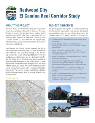
- 1. El Camino Real is a state highway and major transportation corridor serving Redwood City and the Bay Area Peninsula. Through the years, it has developed into a roadway that is oriented to automobiles rather than to pedestrians, bicyclists, and transit riders. Redwood City is beginning a process to create a Corridor Plan for El Camino Real that will improve safety, mobility, economic development, and connections to Downtown and nearby neighborhoods. The El Camino Real Corridor Plan will reexamine the policies and standards for the portion of the El Camino Real Corridor within Redwood City’s jurisdiction. In doing so, the Plan will help transform the Corridor into a “grand boulevard” that links neighborhoods and Downtown and is a destination itself. The Plan will achieve this by including urban design standards to ensure that new development is high quality, a plan for street improvements to make the Corridor more pleasant to walk along and safer to cross, and policies that support small businesses and a range of housing choices along the Corridor, as well as other elements. The Plan will not increase height limits or building densities/intensities beyond what is currently allowed in the zoning ordinance. ABOUT THE PROJECT The ultimate goal for this project is to produce an El Camino Real Corridor Plan to consolidate existing zoning districts, land uses and adopted plans into one cohesive document for the Corridor in Redwood City. Specific objectives for the project are: Project Area PROJECT OBJECTIVES • Consolidate recently re-zoned sections of the Corridor into a cohesive plan • Develop strategies to address current development challenges, such as small, narrow, and shallow lots that have different owners • Improve the Corridor’s relationship with the Caltrain station, downtown core (Downtown Precise Plan area), and surrounding neighborhoods • Improve the streetscape to promote walking, transit, bicycling, and economic development • Incorporate community benefits, such as strategies for affordable housing, transitions from the Corridor to the adjacent residential neighborhoods, and vibrant streetscapes • Create a friendlier place for the people who live and work here: parents, kids, commuters, homeowners, and local businesses • Provide a comprehensive business retention and development strategy, focusing on small businesses • Identify financing mechanism and phasing recommendations to implement public improvements !( ^_ Redwood City North Fair Oaks (Unincorporated) San Carlos Redwood City Station City Hall Hudson St Brew ste r Ave Veterans Blvd Hopkin s Ave Roosevelt Ave Marshall St MainSt ChestnutSt WinslowSt MiddlefieldRd Broadway St ra ncis W ay Valo taRd Sta fford St Jefferson Ave Edgew ood Rd Elm St Broadway LaurelSt Pine St IndustrialW ay DuaneSt JeffersonAve Broadway St W hip ple Ave Broadway St Spring St }}82 }}84 }}84 }}82 £¤101 W hip ple Ave Katherin e Ave Jam es Ave Harrison Ave Roosevelt Ave Oak Ave Redw ood Ave Popla r Ave CenterSt Hudson St Fulton St Clinto n St Adam sSt WillowSt CharterSt Nottingham Ave Dum bartonAve Cypress St Shasta St HemlockAve HazelAve Shasta St Cedar St Beech St DouglasAve Middlefield Rd Buckeye St Buckeye St ChesnutSt Beech St MainSt MapleSt MapleSt Fra nklin St Jefferson Ave Lin coln Ave Vera Ave M adison Ave Jackson Ave W ilson Ave Harrison Ave Cle vela nd St Jam esAve Jam esAve Brewste r Ave Hopkin s Ave Brewste r Ave WalnutSt WalnutSt Winklebleck St W arre n St Allerto n St B St A St FingerAve Arlington Rd Clar em ontA ve C St D St E St Arg uello St Lenolt St Vete ra nsBlvd EatonAve Arc h St Birch St Clinto n St Elm w ood St Fulton St M yrtle St NevadaSt JeffersonAve Brew ste r Ave Oak Ave Redwood Ave Iris St Iris St Johnson St PineSt FaySt Davis St Gra nd St M adisonAve Hudson St St Francis St Vera Ave Upton St Jam es Ave JamesAve RubySt PriceAve Convention Way Maple St Blomquist St HurlingameAve San Mateo Ave BerkshireAve W illiam Ave Bay Rd North Star Academy Red Morton Community Park Hoover Park Union Cemetery Hawes Park City Center Plaza Stafford Park Mezes Park Wellesley Park Palm Park Courthouse Square Roselli Mini Park Fleishman Park Linden Park Jardin de Ninos Park Fair Oaks Community Center Mount Carmel Elementary School Main Street Park Little River Park Sequoia High School Mckinley Institute of Technology Hoover Elementary School John Gill Elementary School Hawes Elementary School Peninsula Christian School Redeemer Lutheran Elementary School Orion Alternative Elementary School Summit Preparatory Charter High School Source: Esri, DigitalGlobe, GeoEye, i-cubed, USDA, USGS, AEX, Getmapping, Aerogrid, IGN, IGP, swisstopo, and the GIS User Community 0 1,500 3,000750 Feet !( Caltrain Station Caltrain US Highway State Highway Ramps Railroads Study Area Parcels Parks/Open Space/Public Facilities Schools/Educational Facilities El Camino Real Corridor Planning Boundary Downtown Precise Plan Boundary Redwood City Limits Figure 1-2 EL CAMINO REAL CORRIDOR PLAN Study Area Data Source: City of Redwood City GIS, 2016; San Mateo County Geographic Information Systems, 2016; ESRI, 2016; Dyett & Bhatia, 2016 Redwood City El Camino Real Corridor Study
- 2. Project Planner Lindy Chan Senior Planner, City of Redwood City (650) 780-7237 elcaminoplan@redwoodcity.org PARTICIPATE Visit the Project Website TIMELINE WWW.REDWOODCITY.ORG/ELCAMINOPLAN The project website is a great place to learn more about the El Camino Real Corridor Plan process and stay informed about events and opportunities to get involved. Find current information about the project, including background, details about meetings and workshops, downloadable versions of materials and completed reports, links to resources, and more! Contact Us Summer 2016 Fall 2016 Winter 2016 Spring 2017 Summer 2017 Community Outreach ––CAG #1 ––Stakeholder Interviews ––CAG #2 ––Community Workshops #1 + #2 ––Planning Commission & City Council Study Sessions ––CAG #3 ––Online Survey ––CAG #4 ––Community Workshops #3 + #4 ––CAG #5 ––Public Hearings: Planning Commission & City Council Technical Work ––Data Gathering and Technical Analysis ––Develop and Review Potential Standards and Street Design Options ––Drafting Corridor Plan