Enviar pesquisa
Carregar
GeoDC June 2012 - GeoCommons
•
0 gostou
•
198 visualizações
Andrew Turner
Seguir
GeoDC Talk on Geocommons
Leia menos
Leia mais
Tecnologia
Denunciar
Compartilhar
Denunciar
Compartilhar
1 de 26
Baixar agora
Baixar para ler offline
Recomendados
Utah dot Gov - Site Architecture
iasaglobal
nsgic 2012 - your plumbing is done!
Marten Hogeweg
Mobile data collection using odk
KARUMBA GATAMA
Data visualization in JavaScript
Wenting ZHAO
Time Series Analytics for Big Fast Data
South West Data Meetup
IT tools in research methodology
mahajanmanu
the evolution of data infrastructure at lianjia
毅 吕
odkk.pptx
odkk.pptx
natnaelmamuye
Introduction of super map gis 10i bitcc technology jayson
GeoMedeelel
Land Development Systems Modernization
Fairfax County
DasData - Cloud Services
Marius Dima
Janitor II
Janitor II
SDIEDU
Dublinked tech workshop_15_dec2011
Dublinked .
Smart Cities, Open Data and SMW - SMWCon Spring 2012 Keynote
Joel Natividad
Gov20LA 2013
Gov20LA 2013
Hillary Hartley
Extreme Productivity in the Enterprise The User is the Developer is the User
coolstuff
CTOs Perspective on Adding Geospatial and Location-based Information
Bradley Brown
Linked_Open_Data_Rome_Netcamp_13
Michele Piunti
New paradigm for national mapping organization
Esri India
LTE Site Check
LTE Site Check
nedimsahin
ADV Slides: Graph Databases on the Edge
DATAVERSITY
RGreenway - TriDroid Presentation
emajewicz
Continuously delivered scalable geoservies
Daniel Fenton
Web Scraping and Data Extraction Service
PromptCloud
20141030 LinDA Workshop echallenges2014 - State of the art in open data infra...
LinDa_FP7
Kicktag - About Kicktag & Cosmos 2014
Kicktag Web Solutions Ltd
Divvy presentation
Divvy presentation
Michael Freeman
Super map solution for mobile surveying and 3d cadastre vella
GeoMedeelel
Charlottesville Data bootcamp 2017
Andrew Turner
State of the Map 2015
Andrew Turner
Mais conteúdo relacionado
Semelhante a GeoDC June 2012 - GeoCommons
Introduction of super map gis 10i bitcc technology jayson
GeoMedeelel
Land Development Systems Modernization
Fairfax County
DasData - Cloud Services
Marius Dima
Janitor II
Janitor II
SDIEDU
Dublinked tech workshop_15_dec2011
Dublinked .
Smart Cities, Open Data and SMW - SMWCon Spring 2012 Keynote
Joel Natividad
Gov20LA 2013
Gov20LA 2013
Hillary Hartley
Extreme Productivity in the Enterprise The User is the Developer is the User
coolstuff
CTOs Perspective on Adding Geospatial and Location-based Information
Bradley Brown
Linked_Open_Data_Rome_Netcamp_13
Michele Piunti
New paradigm for national mapping organization
Esri India
LTE Site Check
LTE Site Check
nedimsahin
ADV Slides: Graph Databases on the Edge
DATAVERSITY
RGreenway - TriDroid Presentation
emajewicz
Continuously delivered scalable geoservies
Daniel Fenton
Web Scraping and Data Extraction Service
PromptCloud
20141030 LinDA Workshop echallenges2014 - State of the art in open data infra...
LinDa_FP7
Kicktag - About Kicktag & Cosmos 2014
Kicktag Web Solutions Ltd
Divvy presentation
Divvy presentation
Michael Freeman
Super map solution for mobile surveying and 3d cadastre vella
GeoMedeelel
Semelhante a GeoDC June 2012 - GeoCommons
(20)
Introduction of super map gis 10i bitcc technology jayson
Land Development Systems Modernization
DasData - Cloud Services
Janitor II
Janitor II
Dublinked tech workshop_15_dec2011
Smart Cities, Open Data and SMW - SMWCon Spring 2012 Keynote
Gov20LA 2013
Gov20LA 2013
Extreme Productivity in the Enterprise The User is the Developer is the User
CTOs Perspective on Adding Geospatial and Location-based Information
Linked_Open_Data_Rome_Netcamp_13
New paradigm for national mapping organization
LTE Site Check
LTE Site Check
ADV Slides: Graph Databases on the Edge
RGreenway - TriDroid Presentation
Continuously delivered scalable geoservies
Web Scraping and Data Extraction Service
20141030 LinDA Workshop echallenges2014 - State of the art in open data infra...
Kicktag - About Kicktag & Cosmos 2014
Divvy presentation
Divvy presentation
Super map solution for mobile surveying and 3d cadastre vella
Mais de Andrew Turner
Charlottesville Data bootcamp 2017
Andrew Turner
State of the Map 2015
Andrew Turner
Crisis Cartography - AAG 2013
Andrew Turner
OpenGovHub - Mapping Social Infrastructure with Social Media
Andrew Turner
OK festival Lightning Talk - Collaborative Open Geospatial Data
Andrew Turner
GeoIQ Stack - Where 2012
Andrew Turner
Geospatial Archiving - Society of American Archivists
Andrew Turner
Playful Explorations of Public and Personal Data - OSCON Data 2011
Andrew Turner
Conversing around Data with Collaborative Analysis - Where2011
Andrew Turner
tech tools for global collaboration 4 good
Andrew Turner
Where2.0 That Matters
Andrew Turner
Humanitarian Mapping - Interaction ICCC
Andrew Turner
Open Access to Multi-Domain Collaborative Geospatial Analysis - AGU 2009
Andrew Turner
Crisis Mapping Lightning Talk Geo Commons
Andrew Turner
How Neogeography Killed GIS
Andrew Turner
Where2.0+Gov2.0 - Gov2.0 Summit
Andrew Turner
Library of Congress - Neogeography and Geospatial data preservation
Andrew Turner
GeoCommons Open-Source GeoCoder
Andrew Turner
Geospatial Analysis in the Cloud
Andrew Turner
Loca(c)tion - Reboot 11
Andrew Turner
Mais de Andrew Turner
(20)
Charlottesville Data bootcamp 2017
State of the Map 2015
Crisis Cartography - AAG 2013
OpenGovHub - Mapping Social Infrastructure with Social Media
OK festival Lightning Talk - Collaborative Open Geospatial Data
GeoIQ Stack - Where 2012
Geospatial Archiving - Society of American Archivists
Playful Explorations of Public and Personal Data - OSCON Data 2011
Conversing around Data with Collaborative Analysis - Where2011
tech tools for global collaboration 4 good
Where2.0 That Matters
Humanitarian Mapping - Interaction ICCC
Open Access to Multi-Domain Collaborative Geospatial Analysis - AGU 2009
Crisis Mapping Lightning Talk Geo Commons
How Neogeography Killed GIS
Where2.0+Gov2.0 - Gov2.0 Summit
Library of Congress - Neogeography and Geospatial data preservation
GeoCommons Open-Source GeoCoder
Geospatial Analysis in the Cloud
Loca(c)tion - Reboot 11
Último
Scaling API-first – The story of a global engineering organization
Radu Cotescu
Strategies for Landing an Oracle DBA Job as a Fresher
Remote DBA Services
Histor y of HAM Radio presentation slide
vu2urc
Partners Life - Insurer Innovation Award 2024
The Digital Insurer
A Domino Admins Adventures (Engage 2024)
Gabriella Davis
04-2024-HHUG-Sales-and-Marketing-Alignment.pptx
HampshireHUG
How to Troubleshoot Apps for the Modern Connected Worker
ThousandEyes
From Event to Action: Accelerate Your Decision Making with Real-Time Automation
Safe Software
IAC 2024 - IA Fast Track to Search Focused AI Solutions
Enterprise Knowledge
Mastering MySQL Database Architecture: Deep Dive into MySQL Shell and MySQL R...
Miguel Araújo
Apidays Singapore 2024 - Building Digital Trust in a Digital Economy by Veron...
apidays
What Are The Drone Anti-jamming Systems Technology?
Antenna Manufacturer Coco
How to Troubleshoot Apps for the Modern Connected Worker
ThousandEyes
Strategies for Unlocking Knowledge Management in Microsoft 365 in the Copilot...
Drew Madelung
GenCyber Cyber Security Day Presentation
Michael W. Hawkins
2024: Domino Containers - The Next Step. News from the Domino Container commu...
Martijn de Jong
08448380779 Call Girls In Diplomatic Enclave Women Seeking Men
Delhi Call girls
Artificial Intelligence: Facts and Myths
Joaquim Jorge
TrustArc Webinar - Stay Ahead of US State Data Privacy Law Developments
TrustArc
CNv6 Instructor Chapter 6 Quality of Service
giselly40
Último
(20)
Scaling API-first – The story of a global engineering organization
Strategies for Landing an Oracle DBA Job as a Fresher
Histor y of HAM Radio presentation slide
Partners Life - Insurer Innovation Award 2024
A Domino Admins Adventures (Engage 2024)
04-2024-HHUG-Sales-and-Marketing-Alignment.pptx
How to Troubleshoot Apps for the Modern Connected Worker
From Event to Action: Accelerate Your Decision Making with Real-Time Automation
IAC 2024 - IA Fast Track to Search Focused AI Solutions
Mastering MySQL Database Architecture: Deep Dive into MySQL Shell and MySQL R...
Apidays Singapore 2024 - Building Digital Trust in a Digital Economy by Veron...
What Are The Drone Anti-jamming Systems Technology?
How to Troubleshoot Apps for the Modern Connected Worker
Strategies for Unlocking Knowledge Management in Microsoft 365 in the Copilot...
GenCyber Cyber Security Day Presentation
2024: Domino Containers - The Next Step. News from the Domino Container commu...
08448380779 Call Girls In Diplomatic Enclave Women Seeking Men
Artificial Intelligence: Facts and Myths
TrustArc Webinar - Stay Ahead of US State Data Privacy Law Developments
CNv6 Instructor Chapter 6 Quality of Service
GeoDC June 2012 - GeoCommons
1.
Andrew Turner @ajturner
2.
Access Visualize Analyze
3.
4.
Organizations Research MediaDevelopers Enterprise Citizens
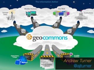
5.
http://geocommons.com 15m+ maps served 100k+
unique datasets billions of features. 4m+ downloads 1m+ geographic attributes
6.
7.
8.
Mapping Elections http://www.washingtonpost.com/blogs/mike- debonis/post/how-ward-5-is-voting-so-far/ 2012/05/10/gIQAgcKNGU_blog.html
9.
Mapping Traffic +
Caffeine http://geocommons.com/maps/ 82402
10.
Social Governance
11.
12.
13.
a few GeoIQ
platform features... • Data upload • Data Parsing • Web Feeds • Dataset Aggregation • Geocoding • Geojoin • Data Permissions • Group Management • Data Cleanup • Metadata management • Tagging • Data export • Dataset caching • External Relational Database integration • User Authentication • LDAP Integration • Thematic Visualization • Spatial, Tabular, Statistical Analysis • User-defined analysis • Stream updating • Mobile web interface • Native mobile applications • Drawing and annotation • Geographic Maps • User defined basemaps • Charts (Pie, Line, etc.) • REST and Javascript API Integration • Facebook integration • OGC Web Services • PNG and PDF Map Export • Multisite Catalog Federation • White Label Customization • Featured Maps • External Analysis Integration • Stats and Tracking • Graceful Map Degradation But make it usable
14.
Streaming Services Streaming Analysis GeoiQ Social REST and
Javascript API GeoiQ Explorer GeoiQ Mobile Tabular Spatial Image Custom Analysis Workers SpatialData ETL SpatialData Management User Management Distributed Object Store GeoiQ Connect MySQL PostgreSQL Oracle Mongo HBase Geospatial SearchIndex Hadoop Distributed Job Queues External Analysis HDFS Federated Data Network OpenStreetMap MapRendering Engine ModestMaps)) &)Polymaps) jQuery'&'' Backbone.js' Ac#onScript+ &+Appcelerator+ AMQP% &%Redis% WebSockets* Socket.io* Ruby%on% Rails% Lucene& &&Solr& Mapnik' Ruby%&% OSGeo% HBase& PostgreSQL+ Node.js(&( MongoDB( Open Architecture
15.
Upload and Share
Data
16.
100,000+ public data
sets
17.
Metadata, Stats, Download
18.
Build Maps in
Seconds
19.
Spatial Operations Buffer, Intersect,
Aggregation Correlation, Prediction, Custom
20.
Spatial Aggregation: Group
data by arbitrary geographic boundaries (Proprietary and confidential)
21.
Spatial Correlation: Relationship
between multiple datasets by geography (Proprietary and confidential)
22.
Traceable Analyses: Analysis
and Filter versions can be tracked back
23.
Dynamic(Data(Verifica.on( (mobile(sensors(+(imagery)(
24.
Mapping Socially embed
live maps in Facebook
25.
Build & Customize
with API http://maps.worldbank.org
Baixar agora