Enviar pesquisa
Carregar
Crisis Mapping Lightning Talk Geo Commons
•
4 gostaram
•
927 visualizações
Andrew Turner
Seguir
Tecnologia
Denunciar
Compartilhar
Denunciar
Compartilhar
1 de 20
Baixar agora
Baixar para ler offline
Recomendados
Gsapp xcities gorman_upload
seagor
ONR Social Media Conference - GeoIQ
seagor
Open Access to Multi-Domain Collaborative Geospatial Analysis - AGU 2009
Andrew Turner
On Coordinated Online Behaviour
Derek Weber
Data Science career mixer poster
Tom Jeon
The Internet of Us: The Makings of a Smart City
Crowdsourcing Week
#ICCSS2015 - Computational Human Security Analytics using "Big Data"
Pete Burnap
State of the Map 2015
Andrew Turner
Humanitarian Mapping - Interaction ICCC
Andrew Turner
Opportunities and Challenges in Crisis Informatics
Lea Shanley
Humanitarian Mapping - InterAction ICCC
guestbfe342
GIS 2.0: Impacts on Humanitarian Affairs and Genocide Studies
Joshua Campbell
The emergent opportunity of Big Data for Social Good - Nuria Oliver @ PAPIs C...
PAPIs.io
ICCM 2014 -- Ignite Talks -- Session 2
International Network of Crisis Mappers
“Data for Development – the value of data for research and society” by Dr. Ma...
LEARN Project
Rocket City Keynote
Rocket City Keynote
Learon Dalby
GIS 2.0, The Disaster Cycle, and It's Implications for Humanitarian Knowledge...
Joshua Campbell
GIS and Agent-based modeling: Part 2
crooksAndrew
Expelling Information of Events from Critical Public Space using Social Senso...
ijtsrd
Role of Social Media in Emergency Situations
Esri
Enhancing Soft Power: using cyberspace to enhance Soft Power
Amit Sheth
TOTEM: Threat Observation, Tracking, and Evaluation Model
John Gerber
IRJET- Milestones and Challenges of Fake News Detection using Digital Forensi...
IRJET Journal
data, big data, open data
Vincenzo Patruno
Listening to the community. Using ICTs for program monitoring
betterplace lab
Towards a More Open World
Alexander Howard
Spatial computing and social media in the context of disaster management
Rashid Ansari
Michael holland ppt
Michael holland ppt
Laura Manley
GeoDC June 2012 - GeoCommons
Andrew Turner
Charlottesville Data bootcamp 2017
Andrew Turner
Mais conteúdo relacionado
Semelhante a Crisis Mapping Lightning Talk Geo Commons
Humanitarian Mapping - Interaction ICCC
Andrew Turner
Opportunities and Challenges in Crisis Informatics
Lea Shanley
Humanitarian Mapping - InterAction ICCC
guestbfe342
GIS 2.0: Impacts on Humanitarian Affairs and Genocide Studies
Joshua Campbell
The emergent opportunity of Big Data for Social Good - Nuria Oliver @ PAPIs C...
PAPIs.io
ICCM 2014 -- Ignite Talks -- Session 2
International Network of Crisis Mappers
“Data for Development – the value of data for research and society” by Dr. Ma...
LEARN Project
Rocket City Keynote
Rocket City Keynote
Learon Dalby
GIS 2.0, The Disaster Cycle, and It's Implications for Humanitarian Knowledge...
Joshua Campbell
GIS and Agent-based modeling: Part 2
crooksAndrew
Expelling Information of Events from Critical Public Space using Social Senso...
ijtsrd
Role of Social Media in Emergency Situations
Esri
Enhancing Soft Power: using cyberspace to enhance Soft Power
Amit Sheth
TOTEM: Threat Observation, Tracking, and Evaluation Model
John Gerber
IRJET- Milestones and Challenges of Fake News Detection using Digital Forensi...
IRJET Journal
data, big data, open data
Vincenzo Patruno
Listening to the community. Using ICTs for program monitoring
betterplace lab
Towards a More Open World
Alexander Howard
Spatial computing and social media in the context of disaster management
Rashid Ansari
Michael holland ppt
Michael holland ppt
Laura Manley
Semelhante a Crisis Mapping Lightning Talk Geo Commons
(20)
Humanitarian Mapping - Interaction ICCC
Opportunities and Challenges in Crisis Informatics
Humanitarian Mapping - InterAction ICCC
GIS 2.0: Impacts on Humanitarian Affairs and Genocide Studies
The emergent opportunity of Big Data for Social Good - Nuria Oliver @ PAPIs C...
ICCM 2014 -- Ignite Talks -- Session 2
“Data for Development – the value of data for research and society” by Dr. Ma...
Rocket City Keynote
Rocket City Keynote
GIS 2.0, The Disaster Cycle, and It's Implications for Humanitarian Knowledge...
GIS and Agent-based modeling: Part 2
Expelling Information of Events from Critical Public Space using Social Senso...
Role of Social Media in Emergency Situations
Enhancing Soft Power: using cyberspace to enhance Soft Power
TOTEM: Threat Observation, Tracking, and Evaluation Model
IRJET- Milestones and Challenges of Fake News Detection using Digital Forensi...
data, big data, open data
Listening to the community. Using ICTs for program monitoring
Towards a More Open World
Spatial computing and social media in the context of disaster management
Michael holland ppt
Michael holland ppt
Mais de Andrew Turner
GeoDC June 2012 - GeoCommons
Andrew Turner
Charlottesville Data bootcamp 2017
Andrew Turner
Crisis Cartography - AAG 2013
Andrew Turner
OpenGovHub - Mapping Social Infrastructure with Social Media
Andrew Turner
OK festival Lightning Talk - Collaborative Open Geospatial Data
Andrew Turner
GeoIQ Stack - Where 2012
Andrew Turner
Geospatial Archiving - Society of American Archivists
Andrew Turner
Playful Explorations of Public and Personal Data - OSCON Data 2011
Andrew Turner
Conversing around Data with Collaborative Analysis - Where2011
Andrew Turner
tech tools for global collaboration 4 good
Andrew Turner
Where2.0 That Matters
Andrew Turner
How Neogeography Killed GIS
Andrew Turner
Where2.0+Gov2.0 - Gov2.0 Summit
Andrew Turner
Library of Congress - Neogeography and Geospatial data preservation
Andrew Turner
GeoCommons Open-Source GeoCoder
Andrew Turner
Geospatial Analysis in the Cloud
Andrew Turner
Loca(c)tion - Reboot 11
Andrew Turner
Hacking Map API's Workshop - Where2.0 2009
Andrew Turner
Your Own Private GeoWeb
Andrew Turner
Where2009 - Hacking Map APIs
Andrew Turner
Mais de Andrew Turner
(20)
GeoDC June 2012 - GeoCommons
Charlottesville Data bootcamp 2017
Crisis Cartography - AAG 2013
OpenGovHub - Mapping Social Infrastructure with Social Media
OK festival Lightning Talk - Collaborative Open Geospatial Data
GeoIQ Stack - Where 2012
Geospatial Archiving - Society of American Archivists
Playful Explorations of Public and Personal Data - OSCON Data 2011
Conversing around Data with Collaborative Analysis - Where2011
tech tools for global collaboration 4 good
Where2.0 That Matters
How Neogeography Killed GIS
Where2.0+Gov2.0 - Gov2.0 Summit
Library of Congress - Neogeography and Geospatial data preservation
GeoCommons Open-Source GeoCoder
Geospatial Analysis in the Cloud
Loca(c)tion - Reboot 11
Hacking Map API's Workshop - Where2.0 2009
Your Own Private GeoWeb
Where2009 - Hacking Map APIs
Último
Cloud Frontiers: A Deep Dive into Serverless Spatial Data and FME
Safe Software
Apidays New York 2024 - APIs in 2030: The Risk of Technological Sleepwalk by ...
apidays
Vector Search -An Introduction in Oracle Database 23ai.pptx
Remote DBA Services
Elevate Developer Efficiency & build GenAI Application with Amazon Q
Bhuvaneswari Subramani
Introduction to Multilingual Retrieval Augmented Generation (RAG)
Zilliz
FWD Group - Insurer Innovation Award 2024
The Digital Insurer
Rising Above_ Dubai Floods and the Fortitude of Dubai International Airport.pdf
Orbitshub
MS Copilot expands with MS Graph connectors
Nanddeep Nachan
Platformless Horizons for Digital Adaptability
WSO2
WSO2's API Vision: Unifying Control, Empowering Developers
WSO2
DEV meet-up UiPath Document Understanding May 7 2024 Amsterdam
UiPathCommunity
Understanding the FAA Part 107 License ..
Christopher Logan Kennedy
presentation ICT roal in 21st century education
jfdjdjcjdnsjd
Why Teams call analytics are critical to your entire business
panagenda
Polkadot JAM Slides - Token2049 - By Dr. Gavin Wood
Juan lago vázquez
Cloud Frontiers: A Deep Dive into Serverless Spatial Data and FME
Safe Software
Connector Corner: Accelerate revenue generation using UiPath API-centric busi...
DianaGray10
Repurposing LNG terminals for Hydrogen Ammonia: Feasibility and Cost Saving
Edi Saputra
AWS Community Day CPH - Three problems of Terraform
Andrey Devyatkin
Exploring Multimodal Embeddings with Milvus
Zilliz
Último
(20)
Cloud Frontiers: A Deep Dive into Serverless Spatial Data and FME
Apidays New York 2024 - APIs in 2030: The Risk of Technological Sleepwalk by ...
Vector Search -An Introduction in Oracle Database 23ai.pptx
Elevate Developer Efficiency & build GenAI Application with Amazon Q
Introduction to Multilingual Retrieval Augmented Generation (RAG)
FWD Group - Insurer Innovation Award 2024
Rising Above_ Dubai Floods and the Fortitude of Dubai International Airport.pdf
MS Copilot expands with MS Graph connectors
Platformless Horizons for Digital Adaptability
WSO2's API Vision: Unifying Control, Empowering Developers
DEV meet-up UiPath Document Understanding May 7 2024 Amsterdam
Understanding the FAA Part 107 License ..
presentation ICT roal in 21st century education
Why Teams call analytics are critical to your entire business
Polkadot JAM Slides - Token2049 - By Dr. Gavin Wood
Cloud Frontiers: A Deep Dive into Serverless Spatial Data and FME
Connector Corner: Accelerate revenue generation using UiPath API-centric busi...
Repurposing LNG terminals for Hydrogen Ammonia: Feasibility and Cost Saving
AWS Community Day CPH - Three problems of Terraform
Exploring Multimodal Embeddings with Milvus
Crisis Mapping Lightning Talk Geo Commons
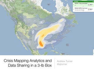
1.
Crisis Mapping Analytics
and Andrew Turner @ajturner Data Sharing in a 3-lb Box
2.
Limits to Current Web Mapping Tools
6
3.
Iden7fy trends and causes
7
4.
4
Network Effect for Data Public Data Enterprise Mobile Data Data Third Sensor Party Data Data
5.
Walking Papers
6.
7.
Easy Data Sharing
8.
Easy Spatial Referencing
9.
Federated
10.
Step By Step
Mapping
11.
Dynamic Data and Temporal
Analysis
12.
Impact Analysis
13.
Education
Threats Population Health Cross-collaboration
14.
Realtime Collaboration
15.
Mobile Input
16.
Portable Google Fusion
Server Portable GeoIQ Appliance Portable Battery Pack Portable Solar Power Offline Web Apps Afghanistan Field Deployment (the 3-lb box)
17.
Spreadsheet
SMS KML Sensors Feeds Federation Federation
18.
Citizen reported incidents
19.
Predicted areas for
violence
20.
Thank you Andrew Turner t:@ajturner e:
andrew@fortiusone.com b: http://highearthorbit.com
Baixar agora