SlideShare uma empresa Scribd logo
1 de 6
Baixar para ler offline
EARTHQUAKE EMERGENCY ROAD NETWORK: Framework for
Prioritization of Road Network in Emergency Response, A Case Study of Lalitpur –
Ward No. 12
Ar. Sweta Amatya Shrestha
Department of Civil Engineering
Institute of engineering
Pulchowk, Lalitpur
swetaamatya@yahoo.com
Abstract
Transportation is the spine for the development of every
nation. In Nepal, road network holds that role. Concerning
many disasters, Nepal could not escape from earthquake, as it
has carved its destructive events in its history till to-date. Great
earthquakes of Nepal like of 1934 and 1988 have caused huge
damages to every sector including road networks. Road
networks vulnerability is the major obscurities in post disaster
phase especially at the first 72 hours of rescue. Being on the
lap of seismic prone country and existence of haphazard urban
setup, situation will be perilous in Kathmandu Valley
aftermath of earthquake. Thus, study focuses on road network
accessibility for rescue operation.
In the study, Inversion Hierarchical Weight Process (IHWP) –
method used in Tehran for accessing road vulnerability, has
been tested in piloted area of Lalitpur - ward no.12. Piloted
area comprises of traditional settlements with high influence of
modern structures with narrow and wide access roads. This
setup resembles most of the core area of Kathmandu Valley.
Thus, it manifests to develop the framework for prioritization
of road network in emergency response phase.
Further, by analyzing road vulnerability, road blockage and
priority routes in the piloted area, road networks have been
prioritized. After conducting task on the area, framework for
road network prioritization for emergency response in
earthquake scenario has been developed which could be used
in other urban sector of Kathmandu Valley for the same
purpose.
Key Words: Road Vulnerability, Emergency Response, IHWP,
Framework
I. INTRODUCTION
Transportation infrastructure is one of the
communicating medium. In context of Nepal, road
networks hold prime importance in this sector. There are
basically nine different types of roads (NRS- 1998) that
have embellished Nepal. Time and again, these
embellishments have been affected by earthquake.
Earthquake of 1988 has portrayed this fact reflecting
both functional as well as physical impacts. These
impacts account much in emergency response phase.
Inaccessibility to the affected area due to debris on road
network has imparted loss of lives in Haiti and result
could be same in context of Kathmandu Valley too.
Therefore, road network accessibility has prominent role
in emergency response phase. These are generally
termed as Emergency Road Network. Physical
characteristics of this sort of road is basically govern by
width of the road, redundancy, selection of the road
avoiding man-made hazards as well as tall constructions
and less selection number. Similarly, vulnerability of
road network is basically governed by building
vulnerability, road vulnerability and road blockage as
well.
For the purpose, study area has been selected in the
Lalitpur municipality Ward number 12. As per ward
profile, this ward occupies 82 hectares of lands. Part of
the community from Tangal to Lagankhel stretch has
been considered. As the study focuses on accessibility,
road stretches surrounding the study area and along
ward 5, 15 and 19 has been considered as the study area.
Figure 1 : Study Area
Existence of mixed residential area incorporating old
and new buildings alongside the road stretches; variation
of road typologies ranging from alleys till black top road
network and mixed land use pattern such as residential
and commercial including street vendors has made the
area vulnerable in aftermath scenario. On the other hand,
Ward Report as well as report by NSET on ward number
12 has depicted on the fact about earthquake
vulnerability of the area. Due to this reason area has
been selected for the study. Figure below gives the
glimpses of the area.
II. METHODOLODY
Research holds Positivist Paradigm as research is based
on quantitative and some qualitative analysis.
Quantitative Approach has been carried out to collect
and analyze the current situation of the study area on
road networks regarding earthquake emergency
response. Further, data has been analyzed through
various calculations. Research holds Deduction logic to
analyze quantitative data through IHWP- method.
Further, Induction logic has been considered to develop
framework from the analyzed data.
Research has been conducted with all 225 numbers of
buildings presented over there as each building accounts
a lot in blockage of road network. Further, study has
been processed following five steps such as
Connectivity, Building Vulnerability, Road
Vulnerability Rank, and Road Network prioritization for
rescue, Road Blockage Analysis, Prioritization of road
network for response operation and finally framework
for prioritization of road network in Emergency
Response has been developed.
III. RESULTS
Connectivity
Connectivity of the study area till open space and
hospital has been considered in the study as these are the
important response function in aftermath scenario. So,
road matrix from community area till Namuna
Machhindra School and Patan hospital has been
considered. These places have been approached in the
area through two stretches from Ity tole and Lagankhel
tole respectively following redundancy characteristics of
emergency road network. Road stretches that connects
those places holds different characteristics as portrayed
in table below:
Road ID
Road
width
Road
length
R1 6'-11"
(Tangal – Prayakpokhari) 11'-2" 564'-9"
5'-1"
R (Prayakpokhari) 5'-3" 162'-3"
R2(Prayakpokhari) 15'-4" 612'
R3 (Tangal – Lagankhel) 14'-6" 306'-9"
R4 (Thati tole-Lagakhel bus park) 17'-7" 849'-5"
R5(Ity tole-Patan Hospital) 26'-4" 600'-3"
R6(Ity tole Stretch) 16'-3" 584'-5"
R7(Lagankhel) 36'-11" 553'-8"
Figure 2 : Alleys Figure 3 : Black Topped road
Figure 4 : Mixed Land use
LEGEND
R1
R
R2
R3
R4
R7
R5
R6
Ity Tole
Prayakpokhari
Tangal
Lagankhel Bus
Park
ThatiTole
Patan
Hospital
Mental
Hospital
Table 1 : Road Typology
Figure 5 : Road Typology
Building Vulnerability
Study area has been shaped with both old and new
buildings ranging from adobe, brick in mud, brick in
cement and reinforced buildings. According to the study
carried out in the area through Rapid Visual Assessment
tool, it has been found that each stretch holds more than
40% of vulnerable buildings. Among them, road R and
R6 holds maximum vulnerable buildings.
Road Vulnerability Rank
Road Vulnerability Ranking has been carried out
through IHWP-method that has been referenced through
Tehran document. This method is applied when single
entity has to be judge by multiple indexes. Indexes
considered here are building quality, population and
building density, inclusion degree, land use and PGA.
These indexes have been ranked according to their
importance as per expert’s view and reverse scoring has
been given accordingly. Table below portrayed the
scenario:
Further, each index has been classified as per surveyed
data and score of each class has been calculated through
formulae presented below:
Primary Score, X = D/N
where, D = Reverse Score based on its rank
N = Number of classes of each indexes
Score for different classes of index,
j = D – (N – i) * X
where, i= Assigned number to different classes of each
index
Calculated score for each class of indexes are presented
below:
.
Based on these criteria, road vulnerability ranking has
been carried out and data portrayed the following facts:
Indexes Classification Score
Building
quality 0-0.4(1) 2
0.4-0.8(2) 4
0.8-1 (3) 6
Building
density 0-0.0.1(1) 1.25
0.1-0.2(2) 2.5
0.2-0.3(3) 3.75
0.3-0.4(4) 5
Population
density 0-2(1) 1.33
2-3(2) 2.67
3-4(3) 4
Inclusion
degree 0-1.0(1) 0.6
1.0-2.0(2) 1.2
2.0-3.0(3) 1.8
3.0-4.0(4) 2.4
4.0-5.0(5) 3
Land use Low risk(1) 0.67
Medium risk(2) 1.33
High risk(3) 2
PGA 300 1
Indexes Rank
Reverse
score
Building Quality 1 6
Building Density 2 5
Population Density 3 4
Inclusion Degree 4 3
Land use 5 2
PGA 6 1
Road ID Road Vulnerability Rank
R3 1
R2 2
R1 3
R6 4
R4 5
R 6
R5 7
Table 2 : Indexes Ranking
Table 4 : Road Vulnerability Rank
Table 3 : Indexes Classification
Road Network Prioritization for rescue
Primary concern on rescue operation is to save life of
the people. During this phase main obscurities will be
vulnerable buildings and land use pattern of the area. So,
concerning these factor roads has been prioritized in the
study area and a result has been accounted as below:
Road Blockage Analysis
Road accessibility is accounted by the presence of
vulnerable buildings along its side. Road blockage
relates to the one third of the height of the vulnerable
building. Based on this data showed the following facts:
Road ID Accessibility
R1 Inaccessible
R Inaccessible
R2 Accessible
R3 Accessible
R4 Accessible
R5 Accessible
R6 Accessible
Prioritization of road network for response operation
Different criteria have given different value and
different priority. So, comparative analysis of road
vulnerability, priority and accessibility has been carried
out to figure out the road prioritization. Result has been
depicted as:
 Priority Road for debris removal
Data has shown that road R1 is vulnerable, holds high
priority for rescue activity and is impassable due to
debris coverage. Therefore, as per the priority this
section of the road must be cleared first.
 Priority Road for Rescue Activity
Data portrayed that road R5 and R6 holds least priority
for rescue activity with low vulnerability and are
accessible so following road matrix has been selected as:
 Road matrix R6-R5 has been selected for the passage
towards hospital
 Road matrix R4 has been selected for the passage to
open space
Road ID Road Priority
R3 1
R2 2
R4 3
R5 4
R1, R6 5
R 6
Road
ID
Vulnerability
Rank
Priority
Road Accessibility
R1 3 5 Inaccessible
R 6 6 Inaccessible
R2 2 2 Accessible
R3 1 1 Accessible
R4 5 3 Accessible
R5 7 4 Accessible
R6 4 5 Accessible
Table 5 : Road Priority Rank
Patan
Hospital
Namuna Machhindra School
Study Area
Ward No: 12
Road R6
Road R4
Road R5
Table 6 : Road Blockage Analysis
Table 7 : Comparative Analysis
Figure 7 : Priority Route for rescue operation
Figure 6 : Road Blockage analysis
R3: Accessible R1: Priority 1
R2:
Accessible
R: Priority 2
IV. CONCLUSION AND RECOMMENDATION
Analysis has shown that IHWP- method is one of the
method that can be used for road vulnerability
assessment. Based on the study carried out, framework
for prioritization of road network for emergency
response has been developed to figure out the priority
routes in other urban sectors of Kathmandu valley.
Recommended framework for prioritization of road
network for emergency response has been presented in
figure below:
This framework will be applicable for the
urban area holding following characteristics:
a. Core urban area with conglomeration of
modern buildings
b. Area holding all five types of buildings like
AD, BC, BM, RC3 and RC5
c. Urban area holding different types of road
typology ranging from alleys, under ways till
main roads
d. Area holding less or no traffic flow
Henceforth, the framework for road network
prioritization has been developed from post disaster
earthquake point of view to facilitate quick accessibility
in aftermath scenario. This framework can further be
used to prioritize road network in other urban sector of
Kathmandu valley holding similar urban characteristics
as that of the piloted area.
Figure 8 : Framework for road network prioritization in Emergency Response
ACKNOWLEDGMENT
I express my sincere gratitude to my supervisors Mr.
Hari Darshan Shrestha (CoRD) and Mr. Surya Narayan
Shrestha (NSET) for their constant guidance and
supervision.
I am gratified to Prof. Dr. Jibraj Pokharel (IOE), Mrs.
Bhubaneshwori Parajuli (NSET), Ar. Inu Salike (IOE),
Mr. Ramesh Guragai (NSET) and Dr. Uttar Kumar
Regmi (Kathmandu Municipality), for their precious
suggestion regarding topic selection.
I am obliged to Mr. Prakash Raghubanshi (TIDP, Singha
Durbar) for his support and guidance throughout thesis
preparation. I am also thankful to Mr. Pradeep Prasad
Koirala (MoHA) for his valuable guidance and
information as an expert in his fields of expertise and
providing necessary document. I would like to thank Mr.
Sagar Krishna Joshi (DUDBC) and Mr. Binaya Charan
Shrestha (DUDBC) for providing necessary materials
and important information needed for the study.
I would like to make special reference to Mr. Kamal
Torabi (Tehran), for clarifying the concept of road
vulnerability assessment used in Tehran. I am equally
grateful towards Mr. Gopi. K. Basyal (NSET) and Mr.
Narendra Man Shakya (IOE) for their guidance in
clarifying the concept of IHWP-method. I am really
grateful towards Dr. Jishnu Subedi (IOE) for providing
materials and guidance regarding RVA-tool.
My sincere thanks go to Ward office of Lalitpur (Ward
No.-12), Ms. Mohan Laxmi Shakya (CDMC member),
Ms. Nidhi Tamrakar (Red Cross) and Ms. Santa Maya
Tamrakar for providing me relevant information related
to the study area.
Last but not the least; I am indebted to my family who
were always been there for my devotion to the work and
thankful to my friends who helped me for the work.
REFERENCES
[1] Carroll, K. (March 2011). Vulnerable
Transportation Networks and Earthquakes: A
Case Study of the Kathmnandu Valley.
[2] Chang, S. E. (n.d.). Measuring Post-Disaster
Transportation System Performance:The 1995
Kobe Earthquake in Comparative Perspective.
Retrieved from www.cive.gifu-
u.ac.jp/~nojima/pdf/2000_transportation_a.pdf.
[3] DOR. (NRS-1998). Nepal Road Statistics.
[4] Earthquake History - National Society for
Earthquake. (n.d.). Retrieved from
www.nset.org.np/nset/php/earthquake_history.p
hp.
[5] Earthquake Tips. (April 2002).
[6] Esmaeil Shieh et al. (May 2007). Assessing
Urban Streets Network Vulnerability against
Earthquake Using IHWP- method and GIS –
Case Study: Zone #6 of Tehran . International
Journal of Disaster Resilience in the Built
Environment .
[7] Tung, P. T. (March 2004). Road Vulnerability
Assessment for Earthquake.
[8] Paudyal, Y. R. (March 2008). Development of
Rapid Visual Seismic Vulnerability Assessment
Tool for Kathmandu Valley. Bhaktapur:
Khwopa Engineering College.
[9] NSET. Kathmandu Valley's Earthquake
Scenario.
[10]Office, W. 1. (Shrawan, 2070). Disaster Risk
Management Plan for Lalitpur Sub-
Metropolitian City, War no 12. Lalitpur.
[11]GoN, D. (May 2011). Seismic Vulnerability
Evaluation Guidelines for Private and Public
Buildings. Nepal.
[12]Gonçalo Caiado, R. M. (n.d.). A New Paradign
in Urban Road Network Seismic Vulnerability.
Retrieved from
www.iscramlive.org/ISCRAM2011/proceeding
s/papers/221.pdf.
[13]Government of Nepal, M. o. (2011). Nepal
Disaster Report 2011. DP Net, UNDP,
actionaid, NSET.
[14]Great Hanshin Earthquake. (n.d.). Retrieved
from
en.wikipedia.org/wiki/Great_Hanshin_earthqua
ke.
[15](NSET)Infrastructure Development in Nepal:
Opportunities and Challenges. (n.d.). Retrieved
from www.scribd.com/doc/112008858/2-
Tulasi-Sitaula-Theme.
[16]Jha, N. K. (2060). An Approach Towards
Earthquake Disaster Management in Historic
City Core, A case study of Patan Dhoka Area.
Nepal.
[17]JICA, M. The Study on Earthquake Disaster
Mitigation.
[18]JICA, M. (March 2002). The Study on
Earthquake Disaster Mitigation . Nepal.

Mais conteúdo relacionado

Mais procurados

TE004, A Study On Feasible Traffic Operation Alternatives At Signalized Inter...
TE004, A Study On Feasible Traffic Operation Alternatives At Signalized Inter...TE004, A Study On Feasible Traffic Operation Alternatives At Signalized Inter...
TE004, A Study On Feasible Traffic Operation Alternatives At Signalized Inter...Saurav Barua
 
Framework Development to Analyze the Distribution System for Upper Karnali Hy...
Framework Development to Analyze the Distribution System for Upper Karnali Hy...Framework Development to Analyze the Distribution System for Upper Karnali Hy...
Framework Development to Analyze the Distribution System for Upper Karnali Hy...IJMERJOURNAL
 
Traffic & transportation – ii
Traffic & transportation – iiTraffic & transportation – ii
Traffic & transportation – iiprahlad reddy
 
barua-2015-ijca-906425
barua-2015-ijca-906425barua-2015-ijca-906425
barua-2015-ijca-906425Saurav Barua
 
Impact of Different Types of Land Use on Transportation System of Dhaka City ...
Impact of Different Types of Land Use on Transportation System of Dhaka City ...Impact of Different Types of Land Use on Transportation System of Dhaka City ...
Impact of Different Types of Land Use on Transportation System of Dhaka City ...Shahadat Hossain Shakil
 
2013 methodology for the calibration of vissim in mixed traffic
2013 methodology for the calibration of vissim in mixed traffic2013 methodology for the calibration of vissim in mixed traffic
2013 methodology for the calibration of vissim in mixed trafficDaniel Sitompul
 
Accident Analysis At The Black Spot: A Case Study
Accident Analysis At The Black Spot: A Case StudyAccident Analysis At The Black Spot: A Case Study
Accident Analysis At The Black Spot: A Case Studyiosrjce
 
Chapter 6 Fundamentals of traffic flow
Chapter 6 Fundamentals of traffic flowChapter 6 Fundamentals of traffic flow
Chapter 6 Fundamentals of traffic flowFayaz Rashid
 
Traffic studies for planning bypasses around towns
Traffic studies for planning bypasses around townsTraffic studies for planning bypasses around towns
Traffic studies for planning bypasses around townskiranchappa
 
5-Modal Split & Traffic Assignment-( Transportation and Traffic Engineering D...
5-Modal Split & Traffic Assignment-( Transportation and Traffic Engineering D...5-Modal Split & Traffic Assignment-( Transportation and Traffic Engineering D...
5-Modal Split & Traffic Assignment-( Transportation and Traffic Engineering D...Hossam Shafiq I
 
Origin & destination survey
Origin & destination surveyOrigin & destination survey
Origin & destination surveyAkash Pandey
 
Methods of route assignment
Methods of route assignmentMethods of route assignment
Methods of route assignmentKathan Sindhvad
 
An index based road feature extraction from LANDSAT-8 OLI images
An index based road feature extraction from LANDSAT-8 OLI imagesAn index based road feature extraction from LANDSAT-8 OLI images
An index based road feature extraction from LANDSAT-8 OLI imagesIJECEIAES
 
Sustainable transporation planning – a systems approach
Sustainable transporation planning – a systems approachSustainable transporation planning – a systems approach
Sustainable transporation planning – a systems approachIAEME Publication
 
USING THE ANALYTIC HIERARCHY PROCESS AND GIS FOR DECISION MAKING IN RURAL HIG...
USING THE ANALYTIC HIERARCHY PROCESS AND GIS FOR DECISION MAKING IN RURAL HIG...USING THE ANALYTIC HIERARCHY PROCESS AND GIS FOR DECISION MAKING IN RURAL HIG...
USING THE ANALYTIC HIERARCHY PROCESS AND GIS FOR DECISION MAKING IN RURAL HIG...IAEME Publication
 
Urban transportation system - methods of route assignment
Urban transportation system - methods of route assignmentUrban transportation system - methods of route assignment
Urban transportation system - methods of route assignmentStudent
 

Mais procurados (18)

TE004, A Study On Feasible Traffic Operation Alternatives At Signalized Inter...
TE004, A Study On Feasible Traffic Operation Alternatives At Signalized Inter...TE004, A Study On Feasible Traffic Operation Alternatives At Signalized Inter...
TE004, A Study On Feasible Traffic Operation Alternatives At Signalized Inter...
 
I1037175
I1037175I1037175
I1037175
 
Framework Development to Analyze the Distribution System for Upper Karnali Hy...
Framework Development to Analyze the Distribution System for Upper Karnali Hy...Framework Development to Analyze the Distribution System for Upper Karnali Hy...
Framework Development to Analyze the Distribution System for Upper Karnali Hy...
 
Traffic & transportation – ii
Traffic & transportation – iiTraffic & transportation – ii
Traffic & transportation – ii
 
barua-2015-ijca-906425
barua-2015-ijca-906425barua-2015-ijca-906425
barua-2015-ijca-906425
 
Impact of Different Types of Land Use on Transportation System of Dhaka City ...
Impact of Different Types of Land Use on Transportation System of Dhaka City ...Impact of Different Types of Land Use on Transportation System of Dhaka City ...
Impact of Different Types of Land Use on Transportation System of Dhaka City ...
 
mix traffic
mix trafficmix traffic
mix traffic
 
2013 methodology for the calibration of vissim in mixed traffic
2013 methodology for the calibration of vissim in mixed traffic2013 methodology for the calibration of vissim in mixed traffic
2013 methodology for the calibration of vissim in mixed traffic
 
Accident Analysis At The Black Spot: A Case Study
Accident Analysis At The Black Spot: A Case StudyAccident Analysis At The Black Spot: A Case Study
Accident Analysis At The Black Spot: A Case Study
 
Chapter 6 Fundamentals of traffic flow
Chapter 6 Fundamentals of traffic flowChapter 6 Fundamentals of traffic flow
Chapter 6 Fundamentals of traffic flow
 
Traffic studies for planning bypasses around towns
Traffic studies for planning bypasses around townsTraffic studies for planning bypasses around towns
Traffic studies for planning bypasses around towns
 
5-Modal Split & Traffic Assignment-( Transportation and Traffic Engineering D...
5-Modal Split & Traffic Assignment-( Transportation and Traffic Engineering D...5-Modal Split & Traffic Assignment-( Transportation and Traffic Engineering D...
5-Modal Split & Traffic Assignment-( Transportation and Traffic Engineering D...
 
Origin & destination survey
Origin & destination surveyOrigin & destination survey
Origin & destination survey
 
Methods of route assignment
Methods of route assignmentMethods of route assignment
Methods of route assignment
 
An index based road feature extraction from LANDSAT-8 OLI images
An index based road feature extraction from LANDSAT-8 OLI imagesAn index based road feature extraction from LANDSAT-8 OLI images
An index based road feature extraction from LANDSAT-8 OLI images
 
Sustainable transporation planning – a systems approach
Sustainable transporation planning – a systems approachSustainable transporation planning – a systems approach
Sustainable transporation planning – a systems approach
 
USING THE ANALYTIC HIERARCHY PROCESS AND GIS FOR DECISION MAKING IN RURAL HIG...
USING THE ANALYTIC HIERARCHY PROCESS AND GIS FOR DECISION MAKING IN RURAL HIG...USING THE ANALYTIC HIERARCHY PROCESS AND GIS FOR DECISION MAKING IN RURAL HIG...
USING THE ANALYTIC HIERARCHY PROCESS AND GIS FOR DECISION MAKING IN RURAL HIG...
 
Urban transportation system - methods of route assignment
Urban transportation system - methods of route assignmentUrban transportation system - methods of route assignment
Urban transportation system - methods of route assignment
 

Destaque

Приоритизация потребностей пользователей 2
Приоритизация потребностей пользователей 2Приоритизация потребностей пользователей 2
Приоритизация потребностей пользователей 2Kostiantyn Hladkov
 
Развитие дизайнера
Развитие дизайнераРазвитие дизайнера
Развитие дизайнераNimax
 

Destaque (7)

Prioritization
PrioritizationPrioritization
Prioritization
 
Effectiveness
EffectivenessEffectiveness
Effectiveness
 
The true users goals (pre)
The true users goals (pre)The true users goals (pre)
The true users goals (pre)
 
Приоритизация потребностей пользователей 2
Приоритизация потребностей пользователей 2Приоритизация потребностей пользователей 2
Приоритизация потребностей пользователей 2
 
Competitive Analysis
Competitive AnalysisCompetitive Analysis
Competitive Analysis
 
UX Methods Training
UX Methods TrainingUX Methods Training
UX Methods Training
 
Развитие дизайнера
Развитие дизайнераРазвитие дизайнера
Развитие дизайнера
 

Semelhante a JOURNAL

IRJET- Identification and Analysis of Accident Blackspots using GIS
IRJET- Identification and Analysis of Accident Blackspots using GISIRJET- Identification and Analysis of Accident Blackspots using GIS
IRJET- Identification and Analysis of Accident Blackspots using GISIRJET Journal
 
“ANALYSIS AND DESIGN OF MDR-34”
“ANALYSIS AND DESIGN OF MDR-34”“ANALYSIS AND DESIGN OF MDR-34”
“ANALYSIS AND DESIGN OF MDR-34”IRJET Journal
 
ASSESSING THE IMPACT OF PUNE METRO ON REAL ESTATE MARKET
ASSESSING THE IMPACT OF PUNE METRO ON REAL ESTATE MARKETASSESSING THE IMPACT OF PUNE METRO ON REAL ESTATE MARKET
ASSESSING THE IMPACT OF PUNE METRO ON REAL ESTATE MARKETIRJET Journal
 
IRJET- A Review Paper on Traffic Regulation at Highway Intersection
IRJET- A Review Paper on Traffic Regulation at Highway IntersectionIRJET- A Review Paper on Traffic Regulation at Highway Intersection
IRJET- A Review Paper on Traffic Regulation at Highway IntersectionIRJET Journal
 
Identification of Blackspots and Accident Analysis using GIS
Identification  of Blackspots and Accident Analysis  using GISIdentification  of Blackspots and Accident Analysis  using GIS
Identification of Blackspots and Accident Analysis using GISIRJET Journal
 
Road Safety Audit of Chamarajanagar to Haradanahalli District Forest - NH 948
Road Safety Audit of Chamarajanagar to Haradanahalli District Forest - NH 948Road Safety Audit of Chamarajanagar to Haradanahalli District Forest - NH 948
Road Safety Audit of Chamarajanagar to Haradanahalli District Forest - NH 948IRJET Journal
 
Feasibility Study of Mass Transport in Nasik City
Feasibility Study of Mass Transport in Nasik CityFeasibility Study of Mass Transport in Nasik City
Feasibility Study of Mass Transport in Nasik CityIRJET Journal
 
Quantifying modelingon risk of travel demand and measure to sustaining road s...
Quantifying modelingon risk of travel demand and measure to sustaining road s...Quantifying modelingon risk of travel demand and measure to sustaining road s...
Quantifying modelingon risk of travel demand and measure to sustaining road s...eSAT Journals
 
IRJET- Simulation of On-Street Parking Under Heterogeneous Urban Traffic ...
IRJET-  	  Simulation of On-Street Parking Under Heterogeneous Urban Traffic ...IRJET-  	  Simulation of On-Street Parking Under Heterogeneous Urban Traffic ...
IRJET- Simulation of On-Street Parking Under Heterogeneous Urban Traffic ...IRJET Journal
 
Presentation_Sahil Singh_26.11.15
Presentation_Sahil Singh_26.11.15Presentation_Sahil Singh_26.11.15
Presentation_Sahil Singh_26.11.15Sahil Singh Kapoor
 
COMPREHENSIVE GIS-BASED SOLUTION FOR ROAD BLOCKAGE DUE TO SEISMIC BUILDING CO...
COMPREHENSIVE GIS-BASED SOLUTION FOR ROAD BLOCKAGE DUE TO SEISMIC BUILDING CO...COMPREHENSIVE GIS-BASED SOLUTION FOR ROAD BLOCKAGE DUE TO SEISMIC BUILDING CO...
COMPREHENSIVE GIS-BASED SOLUTION FOR ROAD BLOCKAGE DUE TO SEISMIC BUILDING CO...Reza Nourjou, Ph.D.
 
Identification and Improvement of Accident Black Spots on N.H.86 District Sag...
Identification and Improvement of Accident Black Spots on N.H.86 District Sag...Identification and Improvement of Accident Black Spots on N.H.86 District Sag...
Identification and Improvement of Accident Black Spots on N.H.86 District Sag...IRJET Journal
 
IRJET- A Case Study on Walkability by GWI Method to Estimate the Pedestrian W...
IRJET- A Case Study on Walkability by GWI Method to Estimate the Pedestrian W...IRJET- A Case Study on Walkability by GWI Method to Estimate the Pedestrian W...
IRJET- A Case Study on Walkability by GWI Method to Estimate the Pedestrian W...IRJET Journal
 
IDENTIFICATION OF BLACKSPOTS IN PALA-THODUPUZHA ROADAND RECOMMENDATION OF REM...
IDENTIFICATION OF BLACKSPOTS IN PALA-THODUPUZHA ROADAND RECOMMENDATION OF REM...IDENTIFICATION OF BLACKSPOTS IN PALA-THODUPUZHA ROADAND RECOMMENDATION OF REM...
IDENTIFICATION OF BLACKSPOTS IN PALA-THODUPUZHA ROADAND RECOMMENDATION OF REM...IRJET Journal
 
IRJET- Land Cover Index Classification using Satellite Images with Different ...
IRJET- Land Cover Index Classification using Satellite Images with Different ...IRJET- Land Cover Index Classification using Satellite Images with Different ...
IRJET- Land Cover Index Classification using Satellite Images with Different ...IRJET Journal
 
Study of Road Safety Audit in Municipal Area’s
Study of Road Safety Audit in Municipal  Area’sStudy of Road Safety Audit in Municipal  Area’s
Study of Road Safety Audit in Municipal Area’sIRJET Journal
 
IRJET- GIS based Road Safety Audit of State Highways in Thrissur
IRJET- GIS based Road Safety Audit of State Highways in ThrissurIRJET- GIS based Road Safety Audit of State Highways in Thrissur
IRJET- GIS based Road Safety Audit of State Highways in ThrissurIRJET Journal
 
Traffic census and analysis (a case study)
Traffic census and analysis (a case study)Traffic census and analysis (a case study)
Traffic census and analysis (a case study)eSAT Journals
 
Designing of a Traffic Signaling System at T-Intersection
Designing of a Traffic Signaling System at T-IntersectionDesigning of a Traffic Signaling System at T-Intersection
Designing of a Traffic Signaling System at T-IntersectionIJERA Editor
 

Semelhante a JOURNAL (20)

IRJET- Identification and Analysis of Accident Blackspots using GIS
IRJET- Identification and Analysis of Accident Blackspots using GISIRJET- Identification and Analysis of Accident Blackspots using GIS
IRJET- Identification and Analysis of Accident Blackspots using GIS
 
“ANALYSIS AND DESIGN OF MDR-34”
“ANALYSIS AND DESIGN OF MDR-34”“ANALYSIS AND DESIGN OF MDR-34”
“ANALYSIS AND DESIGN OF MDR-34”
 
ASSESSING THE IMPACT OF PUNE METRO ON REAL ESTATE MARKET
ASSESSING THE IMPACT OF PUNE METRO ON REAL ESTATE MARKETASSESSING THE IMPACT OF PUNE METRO ON REAL ESTATE MARKET
ASSESSING THE IMPACT OF PUNE METRO ON REAL ESTATE MARKET
 
IRJET- A Review Paper on Traffic Regulation at Highway Intersection
IRJET- A Review Paper on Traffic Regulation at Highway IntersectionIRJET- A Review Paper on Traffic Regulation at Highway Intersection
IRJET- A Review Paper on Traffic Regulation at Highway Intersection
 
Identification of Blackspots and Accident Analysis using GIS
Identification  of Blackspots and Accident Analysis  using GISIdentification  of Blackspots and Accident Analysis  using GIS
Identification of Blackspots and Accident Analysis using GIS
 
Road Safety Audit of Chamarajanagar to Haradanahalli District Forest - NH 948
Road Safety Audit of Chamarajanagar to Haradanahalli District Forest - NH 948Road Safety Audit of Chamarajanagar to Haradanahalli District Forest - NH 948
Road Safety Audit of Chamarajanagar to Haradanahalli District Forest - NH 948
 
Feasibility Study of Mass Transport in Nasik City
Feasibility Study of Mass Transport in Nasik CityFeasibility Study of Mass Transport in Nasik City
Feasibility Study of Mass Transport in Nasik City
 
Quantifying modelingon risk of travel demand and measure to sustaining road s...
Quantifying modelingon risk of travel demand and measure to sustaining road s...Quantifying modelingon risk of travel demand and measure to sustaining road s...
Quantifying modelingon risk of travel demand and measure to sustaining road s...
 
IRJET- Simulation of On-Street Parking Under Heterogeneous Urban Traffic ...
IRJET-  	  Simulation of On-Street Parking Under Heterogeneous Urban Traffic ...IRJET-  	  Simulation of On-Street Parking Under Heterogeneous Urban Traffic ...
IRJET- Simulation of On-Street Parking Under Heterogeneous Urban Traffic ...
 
Presentation_Sahil Singh_26.11.15
Presentation_Sahil Singh_26.11.15Presentation_Sahil Singh_26.11.15
Presentation_Sahil Singh_26.11.15
 
COMPREHENSIVE GIS-BASED SOLUTION FOR ROAD BLOCKAGE DUE TO SEISMIC BUILDING CO...
COMPREHENSIVE GIS-BASED SOLUTION FOR ROAD BLOCKAGE DUE TO SEISMIC BUILDING CO...COMPREHENSIVE GIS-BASED SOLUTION FOR ROAD BLOCKAGE DUE TO SEISMIC BUILDING CO...
COMPREHENSIVE GIS-BASED SOLUTION FOR ROAD BLOCKAGE DUE TO SEISMIC BUILDING CO...
 
Identification and Improvement of Accident Black Spots on N.H.86 District Sag...
Identification and Improvement of Accident Black Spots on N.H.86 District Sag...Identification and Improvement of Accident Black Spots on N.H.86 District Sag...
Identification and Improvement of Accident Black Spots on N.H.86 District Sag...
 
IRJET- A Case Study on Walkability by GWI Method to Estimate the Pedestrian W...
IRJET- A Case Study on Walkability by GWI Method to Estimate the Pedestrian W...IRJET- A Case Study on Walkability by GWI Method to Estimate the Pedestrian W...
IRJET- A Case Study on Walkability by GWI Method to Estimate the Pedestrian W...
 
IDENTIFICATION OF BLACKSPOTS IN PALA-THODUPUZHA ROADAND RECOMMENDATION OF REM...
IDENTIFICATION OF BLACKSPOTS IN PALA-THODUPUZHA ROADAND RECOMMENDATION OF REM...IDENTIFICATION OF BLACKSPOTS IN PALA-THODUPUZHA ROADAND RECOMMENDATION OF REM...
IDENTIFICATION OF BLACKSPOTS IN PALA-THODUPUZHA ROADAND RECOMMENDATION OF REM...
 
IRJET- Land Cover Index Classification using Satellite Images with Different ...
IRJET- Land Cover Index Classification using Satellite Images with Different ...IRJET- Land Cover Index Classification using Satellite Images with Different ...
IRJET- Land Cover Index Classification using Satellite Images with Different ...
 
Study of Road Safety Audit in Municipal Area’s
Study of Road Safety Audit in Municipal  Area’sStudy of Road Safety Audit in Municipal  Area’s
Study of Road Safety Audit in Municipal Area’s
 
IRJET- GIS based Road Safety Audit of State Highways in Thrissur
IRJET- GIS based Road Safety Audit of State Highways in ThrissurIRJET- GIS based Road Safety Audit of State Highways in Thrissur
IRJET- GIS based Road Safety Audit of State Highways in Thrissur
 
Traffic census and analysis (a case study)
Traffic census and analysis (a case study)Traffic census and analysis (a case study)
Traffic census and analysis (a case study)
 
Hc3312471251
Hc3312471251Hc3312471251
Hc3312471251
 
Designing of a Traffic Signaling System at T-Intersection
Designing of a Traffic Signaling System at T-IntersectionDesigning of a Traffic Signaling System at T-Intersection
Designing of a Traffic Signaling System at T-Intersection
 

JOURNAL

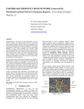
  • 1. EARTHQUAKE EMERGENCY ROAD NETWORK: Framework for Prioritization of Road Network in Emergency Response, A Case Study of Lalitpur – Ward No. 12 Ar. Sweta Amatya Shrestha Department of Civil Engineering Institute of engineering Pulchowk, Lalitpur swetaamatya@yahoo.com Abstract Transportation is the spine for the development of every nation. In Nepal, road network holds that role. Concerning many disasters, Nepal could not escape from earthquake, as it has carved its destructive events in its history till to-date. Great earthquakes of Nepal like of 1934 and 1988 have caused huge damages to every sector including road networks. Road networks vulnerability is the major obscurities in post disaster phase especially at the first 72 hours of rescue. Being on the lap of seismic prone country and existence of haphazard urban setup, situation will be perilous in Kathmandu Valley aftermath of earthquake. Thus, study focuses on road network accessibility for rescue operation. In the study, Inversion Hierarchical Weight Process (IHWP) – method used in Tehran for accessing road vulnerability, has been tested in piloted area of Lalitpur - ward no.12. Piloted area comprises of traditional settlements with high influence of modern structures with narrow and wide access roads. This setup resembles most of the core area of Kathmandu Valley. Thus, it manifests to develop the framework for prioritization of road network in emergency response phase. Further, by analyzing road vulnerability, road blockage and priority routes in the piloted area, road networks have been prioritized. After conducting task on the area, framework for road network prioritization for emergency response in earthquake scenario has been developed which could be used in other urban sector of Kathmandu Valley for the same purpose. Key Words: Road Vulnerability, Emergency Response, IHWP, Framework I. INTRODUCTION Transportation infrastructure is one of the communicating medium. In context of Nepal, road networks hold prime importance in this sector. There are basically nine different types of roads (NRS- 1998) that have embellished Nepal. Time and again, these embellishments have been affected by earthquake. Earthquake of 1988 has portrayed this fact reflecting both functional as well as physical impacts. These impacts account much in emergency response phase. Inaccessibility to the affected area due to debris on road network has imparted loss of lives in Haiti and result could be same in context of Kathmandu Valley too. Therefore, road network accessibility has prominent role in emergency response phase. These are generally termed as Emergency Road Network. Physical characteristics of this sort of road is basically govern by width of the road, redundancy, selection of the road avoiding man-made hazards as well as tall constructions and less selection number. Similarly, vulnerability of road network is basically governed by building vulnerability, road vulnerability and road blockage as well. For the purpose, study area has been selected in the Lalitpur municipality Ward number 12. As per ward profile, this ward occupies 82 hectares of lands. Part of the community from Tangal to Lagankhel stretch has been considered. As the study focuses on accessibility, road stretches surrounding the study area and along ward 5, 15 and 19 has been considered as the study area. Figure 1 : Study Area
  • 2. Existence of mixed residential area incorporating old and new buildings alongside the road stretches; variation of road typologies ranging from alleys till black top road network and mixed land use pattern such as residential and commercial including street vendors has made the area vulnerable in aftermath scenario. On the other hand, Ward Report as well as report by NSET on ward number 12 has depicted on the fact about earthquake vulnerability of the area. Due to this reason area has been selected for the study. Figure below gives the glimpses of the area. II. METHODOLODY Research holds Positivist Paradigm as research is based on quantitative and some qualitative analysis. Quantitative Approach has been carried out to collect and analyze the current situation of the study area on road networks regarding earthquake emergency response. Further, data has been analyzed through various calculations. Research holds Deduction logic to analyze quantitative data through IHWP- method. Further, Induction logic has been considered to develop framework from the analyzed data. Research has been conducted with all 225 numbers of buildings presented over there as each building accounts a lot in blockage of road network. Further, study has been processed following five steps such as Connectivity, Building Vulnerability, Road Vulnerability Rank, and Road Network prioritization for rescue, Road Blockage Analysis, Prioritization of road network for response operation and finally framework for prioritization of road network in Emergency Response has been developed. III. RESULTS Connectivity Connectivity of the study area till open space and hospital has been considered in the study as these are the important response function in aftermath scenario. So, road matrix from community area till Namuna Machhindra School and Patan hospital has been considered. These places have been approached in the area through two stretches from Ity tole and Lagankhel tole respectively following redundancy characteristics of emergency road network. Road stretches that connects those places holds different characteristics as portrayed in table below: Road ID Road width Road length R1 6'-11" (Tangal – Prayakpokhari) 11'-2" 564'-9" 5'-1" R (Prayakpokhari) 5'-3" 162'-3" R2(Prayakpokhari) 15'-4" 612' R3 (Tangal – Lagankhel) 14'-6" 306'-9" R4 (Thati tole-Lagakhel bus park) 17'-7" 849'-5" R5(Ity tole-Patan Hospital) 26'-4" 600'-3" R6(Ity tole Stretch) 16'-3" 584'-5" R7(Lagankhel) 36'-11" 553'-8" Figure 2 : Alleys Figure 3 : Black Topped road Figure 4 : Mixed Land use LEGEND R1 R R2 R3 R4 R7 R5 R6 Ity Tole Prayakpokhari Tangal Lagankhel Bus Park ThatiTole Patan Hospital Mental Hospital Table 1 : Road Typology Figure 5 : Road Typology
  • 3. Building Vulnerability Study area has been shaped with both old and new buildings ranging from adobe, brick in mud, brick in cement and reinforced buildings. According to the study carried out in the area through Rapid Visual Assessment tool, it has been found that each stretch holds more than 40% of vulnerable buildings. Among them, road R and R6 holds maximum vulnerable buildings. Road Vulnerability Rank Road Vulnerability Ranking has been carried out through IHWP-method that has been referenced through Tehran document. This method is applied when single entity has to be judge by multiple indexes. Indexes considered here are building quality, population and building density, inclusion degree, land use and PGA. These indexes have been ranked according to their importance as per expert’s view and reverse scoring has been given accordingly. Table below portrayed the scenario: Further, each index has been classified as per surveyed data and score of each class has been calculated through formulae presented below: Primary Score, X = D/N where, D = Reverse Score based on its rank N = Number of classes of each indexes Score for different classes of index, j = D – (N – i) * X where, i= Assigned number to different classes of each index Calculated score for each class of indexes are presented below: . Based on these criteria, road vulnerability ranking has been carried out and data portrayed the following facts: Indexes Classification Score Building quality 0-0.4(1) 2 0.4-0.8(2) 4 0.8-1 (3) 6 Building density 0-0.0.1(1) 1.25 0.1-0.2(2) 2.5 0.2-0.3(3) 3.75 0.3-0.4(4) 5 Population density 0-2(1) 1.33 2-3(2) 2.67 3-4(3) 4 Inclusion degree 0-1.0(1) 0.6 1.0-2.0(2) 1.2 2.0-3.0(3) 1.8 3.0-4.0(4) 2.4 4.0-5.0(5) 3 Land use Low risk(1) 0.67 Medium risk(2) 1.33 High risk(3) 2 PGA 300 1 Indexes Rank Reverse score Building Quality 1 6 Building Density 2 5 Population Density 3 4 Inclusion Degree 4 3 Land use 5 2 PGA 6 1 Road ID Road Vulnerability Rank R3 1 R2 2 R1 3 R6 4 R4 5 R 6 R5 7 Table 2 : Indexes Ranking Table 4 : Road Vulnerability Rank Table 3 : Indexes Classification
  • 4. Road Network Prioritization for rescue Primary concern on rescue operation is to save life of the people. During this phase main obscurities will be vulnerable buildings and land use pattern of the area. So, concerning these factor roads has been prioritized in the study area and a result has been accounted as below: Road Blockage Analysis Road accessibility is accounted by the presence of vulnerable buildings along its side. Road blockage relates to the one third of the height of the vulnerable building. Based on this data showed the following facts: Road ID Accessibility R1 Inaccessible R Inaccessible R2 Accessible R3 Accessible R4 Accessible R5 Accessible R6 Accessible Prioritization of road network for response operation Different criteria have given different value and different priority. So, comparative analysis of road vulnerability, priority and accessibility has been carried out to figure out the road prioritization. Result has been depicted as:  Priority Road for debris removal Data has shown that road R1 is vulnerable, holds high priority for rescue activity and is impassable due to debris coverage. Therefore, as per the priority this section of the road must be cleared first.  Priority Road for Rescue Activity Data portrayed that road R5 and R6 holds least priority for rescue activity with low vulnerability and are accessible so following road matrix has been selected as:  Road matrix R6-R5 has been selected for the passage towards hospital  Road matrix R4 has been selected for the passage to open space Road ID Road Priority R3 1 R2 2 R4 3 R5 4 R1, R6 5 R 6 Road ID Vulnerability Rank Priority Road Accessibility R1 3 5 Inaccessible R 6 6 Inaccessible R2 2 2 Accessible R3 1 1 Accessible R4 5 3 Accessible R5 7 4 Accessible R6 4 5 Accessible Table 5 : Road Priority Rank Patan Hospital Namuna Machhindra School Study Area Ward No: 12 Road R6 Road R4 Road R5 Table 6 : Road Blockage Analysis Table 7 : Comparative Analysis Figure 7 : Priority Route for rescue operation Figure 6 : Road Blockage analysis R3: Accessible R1: Priority 1 R2: Accessible R: Priority 2
  • 5. IV. CONCLUSION AND RECOMMENDATION Analysis has shown that IHWP- method is one of the method that can be used for road vulnerability assessment. Based on the study carried out, framework for prioritization of road network for emergency response has been developed to figure out the priority routes in other urban sectors of Kathmandu valley. Recommended framework for prioritization of road network for emergency response has been presented in figure below: This framework will be applicable for the urban area holding following characteristics: a. Core urban area with conglomeration of modern buildings b. Area holding all five types of buildings like AD, BC, BM, RC3 and RC5 c. Urban area holding different types of road typology ranging from alleys, under ways till main roads d. Area holding less or no traffic flow Henceforth, the framework for road network prioritization has been developed from post disaster earthquake point of view to facilitate quick accessibility in aftermath scenario. This framework can further be used to prioritize road network in other urban sector of Kathmandu valley holding similar urban characteristics as that of the piloted area. Figure 8 : Framework for road network prioritization in Emergency Response
  • 6. ACKNOWLEDGMENT I express my sincere gratitude to my supervisors Mr. Hari Darshan Shrestha (CoRD) and Mr. Surya Narayan Shrestha (NSET) for their constant guidance and supervision. I am gratified to Prof. Dr. Jibraj Pokharel (IOE), Mrs. Bhubaneshwori Parajuli (NSET), Ar. Inu Salike (IOE), Mr. Ramesh Guragai (NSET) and Dr. Uttar Kumar Regmi (Kathmandu Municipality), for their precious suggestion regarding topic selection. I am obliged to Mr. Prakash Raghubanshi (TIDP, Singha Durbar) for his support and guidance throughout thesis preparation. I am also thankful to Mr. Pradeep Prasad Koirala (MoHA) for his valuable guidance and information as an expert in his fields of expertise and providing necessary document. I would like to thank Mr. Sagar Krishna Joshi (DUDBC) and Mr. Binaya Charan Shrestha (DUDBC) for providing necessary materials and important information needed for the study. I would like to make special reference to Mr. Kamal Torabi (Tehran), for clarifying the concept of road vulnerability assessment used in Tehran. I am equally grateful towards Mr. Gopi. K. Basyal (NSET) and Mr. Narendra Man Shakya (IOE) for their guidance in clarifying the concept of IHWP-method. I am really grateful towards Dr. Jishnu Subedi (IOE) for providing materials and guidance regarding RVA-tool. My sincere thanks go to Ward office of Lalitpur (Ward No.-12), Ms. Mohan Laxmi Shakya (CDMC member), Ms. Nidhi Tamrakar (Red Cross) and Ms. Santa Maya Tamrakar for providing me relevant information related to the study area. Last but not the least; I am indebted to my family who were always been there for my devotion to the work and thankful to my friends who helped me for the work. REFERENCES [1] Carroll, K. (March 2011). Vulnerable Transportation Networks and Earthquakes: A Case Study of the Kathmnandu Valley. [2] Chang, S. E. (n.d.). Measuring Post-Disaster Transportation System Performance:The 1995 Kobe Earthquake in Comparative Perspective. Retrieved from www.cive.gifu- u.ac.jp/~nojima/pdf/2000_transportation_a.pdf. [3] DOR. (NRS-1998). Nepal Road Statistics. [4] Earthquake History - National Society for Earthquake. (n.d.). Retrieved from www.nset.org.np/nset/php/earthquake_history.p hp. [5] Earthquake Tips. (April 2002). [6] Esmaeil Shieh et al. (May 2007). Assessing Urban Streets Network Vulnerability against Earthquake Using IHWP- method and GIS – Case Study: Zone #6 of Tehran . International Journal of Disaster Resilience in the Built Environment . [7] Tung, P. T. (March 2004). Road Vulnerability Assessment for Earthquake. [8] Paudyal, Y. R. (March 2008). Development of Rapid Visual Seismic Vulnerability Assessment Tool for Kathmandu Valley. Bhaktapur: Khwopa Engineering College. [9] NSET. Kathmandu Valley's Earthquake Scenario. [10]Office, W. 1. (Shrawan, 2070). Disaster Risk Management Plan for Lalitpur Sub- Metropolitian City, War no 12. Lalitpur. [11]GoN, D. (May 2011). Seismic Vulnerability Evaluation Guidelines for Private and Public Buildings. Nepal. [12]Gonçalo Caiado, R. M. (n.d.). A New Paradign in Urban Road Network Seismic Vulnerability. Retrieved from www.iscramlive.org/ISCRAM2011/proceeding s/papers/221.pdf. [13]Government of Nepal, M. o. (2011). Nepal Disaster Report 2011. DP Net, UNDP, actionaid, NSET. [14]Great Hanshin Earthquake. (n.d.). Retrieved from en.wikipedia.org/wiki/Great_Hanshin_earthqua ke. [15](NSET)Infrastructure Development in Nepal: Opportunities and Challenges. (n.d.). Retrieved from www.scribd.com/doc/112008858/2- Tulasi-Sitaula-Theme. [16]Jha, N. K. (2060). An Approach Towards Earthquake Disaster Management in Historic City Core, A case study of Patan Dhoka Area. Nepal. [17]JICA, M. The Study on Earthquake Disaster Mitigation. [18]JICA, M. (March 2002). The Study on Earthquake Disaster Mitigation . Nepal.