SlideShare uma empresa Scribd logo
1 de 1
Image Rectification of Three Niagara River Islands
Spencer Podsiadlo, GEG 418 (518), Tao Tang, Department of Geography and Planning
Buffalo Niagara Riverkeeper is completing a project called the Niagara
River Greenway Habitat Conservation Strategy. One thing they would like
to do is characterize loss of island habitat within the river over time. The
challenge of this project is not the acreage change itself but first obtaining
and properly aligning current satellite images with older images so that the
acreage change analysis can be done.
What was first needed were current satellite images which were obtained
from the New York GIS Clearing House site. This site contains a page with
an interactive map where you can zoom in to a particular area and
download the satellite images. By current that means the images came
from 2011.
Next images from 1978 and 1927 were obtained from a page on the
University of Buffalo’s website. Current and historic images were collected
for Buckhorn Island, Luna Island and Three Sisters Islands.
Finally the 2011 images for each island were rectified to the 1978 and 1927
images. This is because the historic images do not have a coordinate
system so doing the acreage change analysis would be invalid if all images
were not using the same coordinate system which is NAD 1983 State
Plane New York West.
Methods or Approach
Introduction
References
Interpretation of Findings
Conclusions
Results
Acknowledgements
Top: Buckhorn 2011.
Bottom: Three Sisters and Luna 2011.
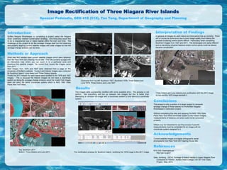
Clockwise from top left: Buckhorn 1927, Buckhorn 1978, Three Sisters and
Luna 1978, Three Sisters and Luna 1927.
The images were successfully rectified with some possible error. The process is not
perfect. Not everything will line up between two images but this is better than
attempting to compare an image with a coordinate system to one without a coordinate
system.
The rectification process for Buckhorn Island, rectifying the 1978 image to the 2011 image.
In general all images for each island and time period line up correctly. There
will of course be some error due to poor image quality thus making the
process of placing control points difficult. Particularly when comparing
Buckhorn images from 1927 and 2011. The landscapes are vastly different
and so identifying physical features where control points could be placed
became complicated.
Three Sisters and Luna Islands post-rectification with the 2011 image
on top and the 1978 image beneath it.
This project is only a portion of a larger project to complete
acreage change of these islands for the Buffalo Niagara
Riverkeeper’s restoration project.
Without completing this step and applying the NAD 1983 State
Plane New York West coordinate system to the historic images,
measurements of distance and area could not be conducted
properly.
Others may be interested to use this process if specific
measurements must be completed for an image with no
coordinate system assigned to it.
Current satellite images are digital orthographic aerial
photographs from New York GIS Clearing House site.
NYS GIS Clearinghouse
http://gis.ny.gov/
Qiao, Jundong. (2014) “Acreage of Island Habitat in Upper Niagara River
Compared to Historic”. Buffalo State College, CIE 507 GIS Class
Project. May, 2014.

Mais conteúdo relacionado

Mais procurados

Aan with gis in rasuwa
Aan with gis in rasuwaAan with gis in rasuwa
Aan with gis in rasuwaDPNet
 
Communicating Arctic climate change through data-driven stories
Communicating Arctic climate change through data-driven storiesCommunicating Arctic climate change through data-driven stories
Communicating Arctic climate change through data-driven storiesZachary Labe
 
Arctic climate change through the lens of data visualization
Arctic climate change through the lens of data visualizationArctic climate change through the lens of data visualization
Arctic climate change through the lens of data visualizationZachary Labe
 
The Pan-Arctic Impacts of Thinning Sea Ice
The Pan-Arctic Impacts of Thinning Sea IceThe Pan-Arctic Impacts of Thinning Sea Ice
The Pan-Arctic Impacts of Thinning Sea IceZachary Labe
 
Avoiding “Surprises” in Seismic Hazard Mapping - Art Frankel
Avoiding “Surprises” in Seismic Hazard Mapping - Art FrankelAvoiding “Surprises” in Seismic Hazard Mapping - Art Frankel
Avoiding “Surprises” in Seismic Hazard Mapping - Art FrankelEERI
 
Using data visualization for effective science (communication)
Using data visualization for effective science (communication)Using data visualization for effective science (communication)
Using data visualization for effective science (communication)Zachary Labe
 
Making Effective Figures
Making Effective FiguresMaking Effective Figures
Making Effective FiguresZachary Labe
 
20130607 arecs web_forecast_video_summer_sun
20130607 arecs web_forecast_video_summer_sun20130607 arecs web_forecast_video_summer_sun
20130607 arecs web_forecast_video_summer_sungtarabanoff
 
focal plane solutions and stress pattern of Sumatra Andaman subduction zone
focal plane solutions and stress pattern of Sumatra Andaman subduction zonefocal plane solutions and stress pattern of Sumatra Andaman subduction zone
focal plane solutions and stress pattern of Sumatra Andaman subduction zoneHamid Hussain
 
Climate Change in the Arctic
Climate Change in the ArcticClimate Change in the Arctic
Climate Change in the ArcticZachary Labe
 
Trends and regional variability of observed Arctic sea-ice thickness
Trends and regional variability of observed Arctic sea-ice thicknessTrends and regional variability of observed Arctic sea-ice thickness
Trends and regional variability of observed Arctic sea-ice thicknessZachary Labe
 
Refining projections of the 'warm Arctic, cold Siberia' pattern in climate mo...
Refining projections of the 'warm Arctic, cold Siberia' pattern in climate mo...Refining projections of the 'warm Arctic, cold Siberia' pattern in climate mo...
Refining projections of the 'warm Arctic, cold Siberia' pattern in climate mo...Zachary Labe
 
gis in natural disaster management geo hazards
gis in natural disaster management  geo hazardsgis in natural disaster management  geo hazards
gis in natural disaster management geo hazardsSoumik Chakraborty
 
2014AerialImageryDisplacement_Report
2014AerialImageryDisplacement_Report2014AerialImageryDisplacement_Report
2014AerialImageryDisplacement_ReportKrystle Keese
 
Earthquake-prone Zonation of North Bengkulu Based on Peak Ground Acceleration...
Earthquake-prone Zonation of North Bengkulu Based on Peak Ground Acceleration...Earthquake-prone Zonation of North Bengkulu Based on Peak Ground Acceleration...
Earthquake-prone Zonation of North Bengkulu Based on Peak Ground Acceleration...INFOGAIN PUBLICATION
 

Mais procurados (20)

Aan with gis in rasuwa
Aan with gis in rasuwaAan with gis in rasuwa
Aan with gis in rasuwa
 
Communicating Arctic climate change through data-driven stories
Communicating Arctic climate change through data-driven storiesCommunicating Arctic climate change through data-driven stories
Communicating Arctic climate change through data-driven stories
 
Arctic climate change through the lens of data visualization
Arctic climate change through the lens of data visualizationArctic climate change through the lens of data visualization
Arctic climate change through the lens of data visualization
 
STARPoster_Lykens
STARPoster_LykensSTARPoster_Lykens
STARPoster_Lykens
 
The Pan-Arctic Impacts of Thinning Sea Ice
The Pan-Arctic Impacts of Thinning Sea IceThe Pan-Arctic Impacts of Thinning Sea Ice
The Pan-Arctic Impacts of Thinning Sea Ice
 
Avoiding “Surprises” in Seismic Hazard Mapping - Art Frankel
Avoiding “Surprises” in Seismic Hazard Mapping - Art FrankelAvoiding “Surprises” in Seismic Hazard Mapping - Art Frankel
Avoiding “Surprises” in Seismic Hazard Mapping - Art Frankel
 
Using data visualization for effective science (communication)
Using data visualization for effective science (communication)Using data visualization for effective science (communication)
Using data visualization for effective science (communication)
 
PNG Multi Client Study
PNG Multi Client StudyPNG Multi Client Study
PNG Multi Client Study
 
poster306
poster306poster306
poster306
 
Making Effective Figures
Making Effective FiguresMaking Effective Figures
Making Effective Figures
 
20130607 arecs web_forecast_video_summer_sun
20130607 arecs web_forecast_video_summer_sun20130607 arecs web_forecast_video_summer_sun
20130607 arecs web_forecast_video_summer_sun
 
focal plane solutions and stress pattern of Sumatra Andaman subduction zone
focal plane solutions and stress pattern of Sumatra Andaman subduction zonefocal plane solutions and stress pattern of Sumatra Andaman subduction zone
focal plane solutions and stress pattern of Sumatra Andaman subduction zone
 
Climate Change in the Arctic
Climate Change in the ArcticClimate Change in the Arctic
Climate Change in the Arctic
 
CV mona-rev 2
CV mona-rev 2CV mona-rev 2
CV mona-rev 2
 
Trends and regional variability of observed Arctic sea-ice thickness
Trends and regional variability of observed Arctic sea-ice thicknessTrends and regional variability of observed Arctic sea-ice thickness
Trends and regional variability of observed Arctic sea-ice thickness
 
Refining projections of the 'warm Arctic, cold Siberia' pattern in climate mo...
Refining projections of the 'warm Arctic, cold Siberia' pattern in climate mo...Refining projections of the 'warm Arctic, cold Siberia' pattern in climate mo...
Refining projections of the 'warm Arctic, cold Siberia' pattern in climate mo...
 
GIS Applications Portfolio
GIS Applications PortfolioGIS Applications Portfolio
GIS Applications Portfolio
 
gis in natural disaster management geo hazards
gis in natural disaster management  geo hazardsgis in natural disaster management  geo hazards
gis in natural disaster management geo hazards
 
2014AerialImageryDisplacement_Report
2014AerialImageryDisplacement_Report2014AerialImageryDisplacement_Report
2014AerialImageryDisplacement_Report
 
Earthquake-prone Zonation of North Bengkulu Based on Peak Ground Acceleration...
Earthquake-prone Zonation of North Bengkulu Based on Peak Ground Acceleration...Earthquake-prone Zonation of North Bengkulu Based on Peak Ground Acceleration...
Earthquake-prone Zonation of North Bengkulu Based on Peak Ground Acceleration...
 

Destaque

Destaque (12)

A Brief History of Cryptographic Failures - Mork
A Brief History of Cryptographic Failures - MorkA Brief History of Cryptographic Failures - Mork
A Brief History of Cryptographic Failures - Mork
 
Overview of TCP IP
Overview of TCP IPOverview of TCP IP
Overview of TCP IP
 
Semana 6 - Enrutamiento
Semana 6 - EnrutamientoSemana 6 - Enrutamiento
Semana 6 - Enrutamiento
 
Generating searchable public key ciphertexts
Generating searchable public key ciphertextsGenerating searchable public key ciphertexts
Generating searchable public key ciphertexts
 
Power Leveling your TypeScript
Power Leveling your TypeScriptPower Leveling your TypeScript
Power Leveling your TypeScript
 
tcp_udp [Redes de Computadoras] [Semana 7]
tcp_udp [Redes de Computadoras] [Semana 7]tcp_udp [Redes de Computadoras] [Semana 7]
tcp_udp [Redes de Computadoras] [Semana 7]
 
React & Redux in Hulu
React & Redux in HuluReact & Redux in Hulu
React & Redux in Hulu
 
Alkanes
AlkanesAlkanes
Alkanes
 
Advanced JAVA
Advanced JAVAAdvanced JAVA
Advanced JAVA
 
Project Scheduling, Planning and Risk Management
Project Scheduling, Planning and Risk ManagementProject Scheduling, Planning and Risk Management
Project Scheduling, Planning and Risk Management
 
PROTOCOLO TCP/IP
PROTOCOLO TCP/IP PROTOCOLO TCP/IP
PROTOCOLO TCP/IP
 
Oldcastle Precast Spokane - Urban Modular Construction - The Grand Hotel
Oldcastle Precast Spokane - Urban Modular Construction - The Grand HotelOldcastle Precast Spokane - Urban Modular Construction - The Grand Hotel
Oldcastle Precast Spokane - Urban Modular Construction - The Grand Hotel
 

RS powerpoint

  • 1. Image Rectification of Three Niagara River Islands Spencer Podsiadlo, GEG 418 (518), Tao Tang, Department of Geography and Planning Buffalo Niagara Riverkeeper is completing a project called the Niagara River Greenway Habitat Conservation Strategy. One thing they would like to do is characterize loss of island habitat within the river over time. The challenge of this project is not the acreage change itself but first obtaining and properly aligning current satellite images with older images so that the acreage change analysis can be done. What was first needed were current satellite images which were obtained from the New York GIS Clearing House site. This site contains a page with an interactive map where you can zoom in to a particular area and download the satellite images. By current that means the images came from 2011. Next images from 1978 and 1927 were obtained from a page on the University of Buffalo’s website. Current and historic images were collected for Buckhorn Island, Luna Island and Three Sisters Islands. Finally the 2011 images for each island were rectified to the 1978 and 1927 images. This is because the historic images do not have a coordinate system so doing the acreage change analysis would be invalid if all images were not using the same coordinate system which is NAD 1983 State Plane New York West. Methods or Approach Introduction References Interpretation of Findings Conclusions Results Acknowledgements Top: Buckhorn 2011. Bottom: Three Sisters and Luna 2011. Clockwise from top left: Buckhorn 1927, Buckhorn 1978, Three Sisters and Luna 1978, Three Sisters and Luna 1927. The images were successfully rectified with some possible error. The process is not perfect. Not everything will line up between two images but this is better than attempting to compare an image with a coordinate system to one without a coordinate system. The rectification process for Buckhorn Island, rectifying the 1978 image to the 2011 image. In general all images for each island and time period line up correctly. There will of course be some error due to poor image quality thus making the process of placing control points difficult. Particularly when comparing Buckhorn images from 1927 and 2011. The landscapes are vastly different and so identifying physical features where control points could be placed became complicated. Three Sisters and Luna Islands post-rectification with the 2011 image on top and the 1978 image beneath it. This project is only a portion of a larger project to complete acreage change of these islands for the Buffalo Niagara Riverkeeper’s restoration project. Without completing this step and applying the NAD 1983 State Plane New York West coordinate system to the historic images, measurements of distance and area could not be conducted properly. Others may be interested to use this process if specific measurements must be completed for an image with no coordinate system assigned to it. Current satellite images are digital orthographic aerial photographs from New York GIS Clearing House site. NYS GIS Clearinghouse http://gis.ny.gov/ Qiao, Jundong. (2014) “Acreage of Island Habitat in Upper Niagara River Compared to Historic”. Buffalo State College, CIE 507 GIS Class Project. May, 2014.